Search results
Page title matches
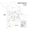
File:East Uletha overview.png Overview of East Uletha, the grouping of territories into sectors based on climactic and cultural s(3,313 × 3,333 (1.45 MB)) - 22:25, 17 October 2021
File:West Uletha Sectors map.png West Uletha sectors map, created by [[User:Stjur]] from trace of OGF map data.(2,725 × 2,724 (885 KB)) - 02:48, 17 December 2021
File:East Uletha sectors illustration.png Artistic interpretation of sectors in East Uletha. Own work in Inkscape by [[User:Eklas]](1,890 × 1,890 (572 KB)) - 22:49, 17 October 2021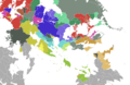
File:East uletha culture proposal.png (2,710 × 1,770 (1.38 MB)) - 16:32, 27 June 2022


Page text matches
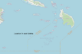
File:Tolulu relation.png Location of Tolulu in eastern Uletha(1,413 × 945 (300 KB)) - 12:27, 11 February 2023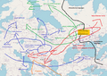
File:Language map proposal.png Proposal for proto-languages and migrations in Uletha (excluding Japanese and Korean so far)(1,155 × 817 (419 KB)) - 11:44, 19 November 2023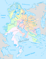
File:Wu waters.png [[Category:West Uletha]](1,937 × 2,480 (1.22 MB)) - 15:31, 13 May 2024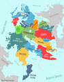
File:WuRegions.png [[Category:West Uletha]](1,937 × 2,480 (780 KB)) - 15:19, 3 May 2024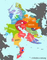
File:WuLanguages.png [[Category:West Uletha]](1,937 × 2,480 (598 KB)) - 15:21, 3 May 2024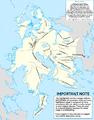
File:Wu mt ranges.png [[Category:West Uletha]](1,937 × 2,480 (1.11 MB)) - 20:20, 13 May 2024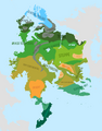
File:WuBiomes.png [[Category:West Uletha]](1,937 × 2,480 (482 KB)) - 15:18, 3 May 2024
File:CHESU.png Logo of the Forum for Cultural Heritage and Exchange in South Uletha. Own work.(750 × 201 (40 KB)) - 11:53, 2 March 2024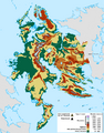
File:Wu ele.png [[Category:West Uletha]](1,937 × 2,480 (1.05 MB)) - 20:21, 13 May 2024
File:EUC-Sudo-UL25.png Sudo91's proposal for UL25 as part of updating the East Uletha Concept. Made with Adobe Illustrator.(1,754 × 739 (169 KB)) - 10:18, 9 August 2022File:East Uletha sectors illustration.png Artistic interpretation of sectors in East Uletha. Own work in Inkscape by [[User:Eklas]](1,890 × 1,890 (572 KB)) - 22:49, 17 October 2021
File:Suecc-hq.jpg Headquarters of the Southern Uletha Economic Cooperation Council, Gobras City, Gobrassanya.(419 × 271 (73 KB)) - 20:02, 13 March 2022File:East Uletha overview.png Overview of East Uletha, the grouping of territories into sectors based on climactic and cultural s(3,313 × 3,333 (1.45 MB)) - 22:25, 17 October 2021File:West Uletha Sectors map.png West Uletha sectors map, created by [[User:Stjur]] from trace of OGF map data.(2,725 × 2,724 (885 KB)) - 02:48, 17 December 2021
File:SUMF.png Logo of the South Uletha Monetary Fund. Made by user [[User:Bixelkoven|Bixelkoven]], uploaded with p(2,065 × 441 (76 KB)) - 21:07, 29 May 2022
File:Suecc-logo.png Logo of the Southern Uletha Economic Cooperation Council(280 × 74 (14 KB)) - 20:08, 13 March 2022


