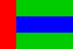
Neberly

|
Neberly Kingdom of Neberly (Ingerish) Capital: Senford
Population: 24,673,296 (2023) Motto: Guided by strength and wisdom Anthem: Where the wide river flows |
Loading map... |
Neberly is a country in northeastern Uletha. In the south it borders the countries of Brevinfeld, Älved, Boscunis and Ogesten; it's eastern neighbor is the country of Eelanti. The northern and western neighboring countries are still uninhabited. Compared to its total border of over 5500 km there's a small coastline, some 400 km long.
| Kingdom of Neberly | |||
|---|---|---|---|
| |||
Loading map... | |||
| Motto: "Guided by strength and wisdom" | |||
| Anthem: Where the wide river flows | |||
| Capital | Senford | ||
| Official languages | Ingerish | ||
| Government | Constitutional Monarchy | ||
| • Monarch | TBD | ||
| • Prime Minister | TBD | ||
| Legislature | Parliament | ||
| • Upper house | House of delegates | ||
| • Lower house | House of representives | ||
| Area | |||
| • Total | 351,567 km² km2 135,741 sq mi² sq mi | ||
| Population | |||
| • Estimate (2023) | 24,673,296 | ||
| • Density | 70.18/km2 181.77/sq mi | ||
| GDP (PPP) | 2019 | ||
| • Total | $1326.752 billion | ||
| • Per capita | $56,330 | ||
| HDI (2019) | very high | ||
| Timezone | WUT + 8 | ||
| Currency | Neberlian Dank (NDA) | ||
| Drives on the | right | ||
Etymology
Neberly is derived from its main river Neber, what is also the main geographical feature. The main source of this river and its tributaries are in the western part of the country. In the province of Slarningworth the main branches, Green Neber and White Neber, merge to one river that continues its course further east. Just outside the city of Binburg the river mouths into the Budhead Bay with a delta
Provinces
Neberly is divided into 28 provinces:
| Code | Name | Capital | Area (in km2) | Population (2020) | Density (2020) | Map Link |
|---|---|---|---|---|---|---|
| NE.01 | Nontford | Senford | 17,090 | 7,943,180 | 464.78 | map |
| NE.02 | Guntbourne | Binburg | 6,789 | 1,274,155 | 187.67 | map |
| NE.03 | Flunborough | Prentbridge | 10,823 | 1,247,234 | 115.24 | map |
| NE.04 | Wunnley | Satbridge | 14,819 | 944,658 | 63.75 | map |
| NE.05 | Dundham | Fondhead | 4,660 | 737,980 | 158.37 | map |
| NE.06 | Plenfingbury | Kendingbury | 8,071 | 583,169 | 72.25 | map |
| NE.07 | Canley | Farnford | 9,070 | 431,118 | 47.53 | map |
| NE.08 | Plardingworth | Prudhattan | 23,434 | 902,357 | 38.51 | map |
| NE.09 | Grufingburg | Wardingbury | 7,931 | 475,507 | 59.95 | map |
| NE.10 | Wunnway | Faningbury | 13,615 | 449,070 | 32.98 | map |
| NE.11 | Slarningworth | Slarningworth | 11,604 | 2,247,577 | 193.69 | map |
| NE.12 | Treburg | Flaningley | 16,333 | 564,722 | 34.57 | map |
| NE.13 | West Chuntway | Dinnbridge | 9,727 | 430,823 | 44.29 | map |
| NE.14 | Pondwood | Drinnville | 17,102 | 354,763 | 20.74 | map |
| NE.15 | Frethill | Frethill | 17,120 | 364,825 | 21.31 | map |
| NE.16 | Bratborough | Hardtown | 11,480 | 353,670 | 30.81 | map |
| NE.17 | Dardwood | Manville | 6,897 | 248,416 | 36.02 | map |
| NE.18 | Frindinghead | Quardwood | 9,885 | 438,095 | 44.32 | map |
| NE.19 | Pintbourne | Frenbridge | 15,147 | 311,511 | 20.57 | map |
| NE.20 | East Chuntway | Kindinghattan | 5,778 | 262,463 | 45.42 | map |
| NE.21 | Dufield | Wrinham | 17,187 | 433,410 | 25.22 | map |
| NE.22 | Tentfield | Pronthill | 18,376 | 505,250 | 27.50 | map |
| NE.23 | Slondingstone | Slondingstone | 8,014 | 366,173 | 45.69 | map |
| NE.24 | Fenfingborough | Drundwood | 24,069 | 521,056 | 21.65 | map |
| NE.25 | Gonfingburg | Wrufingley | 21,580 | 534,091 | 24.75 | map |
| NE.26 | Chardingbury | Plinfingford | 8,568 | 266,921 | 31.15 | map |
| NE.27 | Prarfingfield | Wunfingburg | 4,819 | 207,921 | 43.14 | map |
| NE.28 | Tondstone | Ronfingfield | 11,578 | 494,092 | 42.67 | map |
