Administrative divisions of Izaland: Difference between revisions
mNo edit summary |
m (Moved demography section into here) |
||
| Line 318: | Line 318: | ||
|- | |- | ||
|} | |} | ||
==Demographics== | |||
{{Infobox demography | |||
| name = Izaland | |||
| demonym = Izaki | |||
| official_languages = Izaki | |||
| minority_languages = Aynu Itak, Konbaki, Eituus | |||
| ethnicity_bars = {{bar percent|Izaki|blue|92.1}}{{bar percent|Other Ulethan|cornflowerblue|4.5}}{{bar percent|Northern Archantan|gold|2.5}}{{bar percent|Other|black|0.9}} | |||
| religion_bars = {{bar percent|Peritan Christicism|blue|43.4}}{{bar percent|Budicism|red|28.3}}{{bar percent|Other|orange|2.1}}{{bar percent|Irreligious|gray|21.2}} | |||
| literacy = {{steady}} 100% | |||
| life_expectancy = {{steady}} 80 (male)<br /> {{decrease}} 85 (female) | |||
}} | |||
With a population of more than 117 millions of inhabitants, Izaland is a heavily densely populated country (about 385 people per sq km), especially considering that vast inner areas of Kubori island and the north-east are not interested by an intensive urban development. The 92,1 of the population belongs to the Izaki ethnicity, with the remaining 7,9% being immigrants, mostly from Pasundan-Padjadjaran, Wiwaxia and Commonia's countries, and other expats from other countries in Uletha (Belphenia, Kojo, Saikyel). | |||
The population of Izaland is largely urban, as the major economic centers since the beginning of industrialization have attracted a large part of the young population from rural areas. | |||
===Race=== | |||
It is difficult to trace a genetic profile of the Izanish race, as since the dawn of time there has been a profound mixture of different ethnic groups, both Uletian and Arcanthic. Physiognomically, Izanish people's face appears to be of an oriental type, with dark hair, black almond-shaped eyes and a slightly pronounced nose. However, there is no lack of genotypes belonging to more Western races, such as lighter colored eyes (ocher, olive green and, very rarely, blue) and hair tending to brown. | |||
===Urban planning=== | |||
A characteristic of the territorial development of Izaki urban centers lies in the fact that, compared to other nations, there are few small isolated villages, while the number of large and medium-sized cities is greater. This is due not only to a greater ease in the distribution of goods, but also to the ancient philosophy of "''jiyenchohwashisān''" (自然調和思想), or "thought of harmony with nature", drawn up from the 5th century BC by the Taemasa dynasty. | |||
This method of land planning was based on both scientific and astrological criteria, and the positioning of towns and villages was well defined. As the Taemasa dynasty aggregated, through conquests, new territories that had independently developed their regional urban planning, it came, in certain cases, to relocate entire villages, if they did not respect the precepts of the "''jiyenchohwashisān''". | |||
Although urban planning is still based on modern criteria, the ministry of the environment keeps a careful eye in order to avoid land consumption in the territory. | |||
===Major metropolitan areas=== | |||
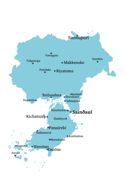
In addition to the Greater Sainðaul area (about 23.4 million inhabitants), other noteworthy metropolitan areas are that of Warohan-Eyenniyul (15 million), Panaireki (5.6 million), Kichatsura (3.2 million), Isadashi (2.7 million), Shirukami-Sahnajima (1.7 million), Makkeriya (Riyatoma and Makkenoke, 2.9 million), Sannupuri (2.2 million), Daishin (1.6 million), Ikkashiya-Katayoshi ( 1.7 million) and Reilusahna (1.5 million). | |||
Other towns of some importance are, in no particular order: Atsujīl, Sagoma, Kanlisahna, Muanake, Jinneisoke, Nagareki and Poridake. | |||
== Telecommunications == | == Telecommunications == | ||
Revision as of 21:43, 8 August 2022
This page is about the administrative divisions and infrastructures of Izaland.
 Main article: Izaland
 | |
|---|---|
| Administrative divisions of Izaland | |
| First-level | 24 prefectures (縣, ken) Capital Special Administration District (首都特別自治区, Shuto tukubyeschitsiku) 1 special city (特別市, tukubyesshi) 1 territory (土, do) |
| Second-level | city (市, -shi), town (町, -chō), and village (村, -son) |
| Third-level | ward (区, -ku), neighborhood (洞, dōn), and rural hamlet (邑, -ūs) |
Administrative Divisions
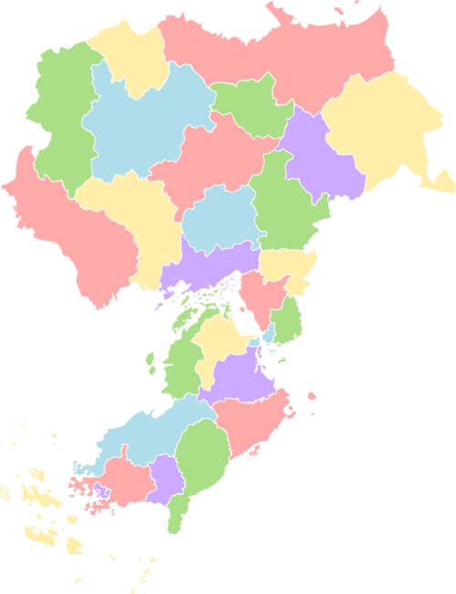
The Republic of Izaland is divided into 29 local entities, including 24 prefectures (縣, ken), the Capital Special Administration District (首都特別自治区, Shuto tukubyeschitsiku), the special city of Warohan (深湾特別市, Warohan tukubyesshi) and the special territory of Yenkaido Prefecture (遠海土, Yenkaido). At the same time, in the north of Kubori Island La Piana (等平奈領, La Pyāna ryō) is located. La Piana is de facto a Plevian speaking independent entity, although certain political functions such as foreign relations and defense are managed by Izaland on behalf.
After these subdivisions, according to the size of the settlement, cities (市, -shi), towns (町, -chō), and villages (村, -son) are found. Criteria for these categories vary according to the different prefecture, but in general cities must have a population of at least 50,000 people, towns between 15,000 and 49,999, and villages under 15,000. There are cities even with less than 50,000 people, as well as towns with more than 50,000, such as Nappawa (78.669 people).
| Flag | District Name | Hanji writing | Postal abbrev. |
District Capital | Area (km2) | Population | Pop.
Density |
|---|---|---|---|---|---|---|---|

|
Yenkaido | 遠海土 | YK | Sannupuri (乾山市) | 33.938,70 | 3.298.780 | 97,20 |

|
Dōnpuku | 東北縣 | DP | Sonzhin (尊神市) | 24.219,53 | 897,220 | 37,07 |

|
Usmashaki | 越馬石懸 | UM | Rihaul (高崎市) | 9.356,01 | ||

|
Makkenoke | 平坂懸 | MN | Makkenoke (平坂市) | 8.572,31 | ||

|
Shinsun | 信旬懸 | SU | Hidankoibo (森袋市) | 12.081,30 | ||

|
Nikorenatsuki | 越不原懸 | NT | Tsobunetoka (旭市市) | 18.951,05 | ||

|
Kasaki | 加羽懸 | KS | Poridake (登館市) | 25.088,93 | ||

|
Riyatoma | 追庥懸 | RT | Riyatoma (追庥市) | 16.937,74 | 7.256.780 | 428,43 |
| Sahasamo | 佐羽山縣 | SS | Yuisheo | 12.934,29 | 425.700 | 267,03 | |

|
Toasa | 土阿嵯懸 | TA | Nagareki (沼浦市) | 25.719,72 | ||

|
Anbira | 案備羅懸 | AR | Tarago (多羅悟市) | 17.066,85 | ||
| Yuttsamo | 氷山縣 | YS | Gaintei | 10.493,46 | 782.500 | 424,46 | |
| Kwando | 関渡縣 | KD | Shirukami(荒釜市) | 9.156,26 | 1.456.609 | 989,01 | |
| Otsumisamo | 東山縣 | OS | Isadashi (安村市) | 4.925,90 | 3.287.980 | 667,48 | |
| Karuhama | 松島縣 | KH | Kawayatsu (嘉夬苫市) | 1376,34 | 1.867.900 | 1.357,15 | |
| National Capital District | 首都特別自治区 | CD | Sainðaul (作安崎) | 502,60 | 12.345.600 | 24.563,47 | |
| Tōkai | 東海縣 | TK | Sabullan (𖬖𖬇𖬰𐐢𖬈𖬳ᐢ市) | 3.164,84 | 3.567.809 | 1.127,33 | |
| Komokata | 其泉縣 | KT | Riimibaiken | 3.164,84 | 5.560.398 | 1.476,92 | |
| Otsumirunka | 東道縣 | OR | Onnojaris (恩之鰹市) | 4059,05 | 521.920 | 128,58 | |
| La Piana | 等平奈領 | LP | La Piana | 10,38 | 252 | 24,28 | |
| Midōhinnan | 美道花縣 | MH | Kichatsura (亀茶汐市) | 974,55 | 652.069 | 669,10 | |
| Nawatsawa | 翠林縣 | NT | Kanlisahna (船灣市) | 2754,35 | 927.556 | 336,76 | |
| Ōhan | 大弯縣 | ON | Panaireki (若浦市) | 5626,98 | 4.456.772 | 792,04 | |
| Warohan Special City | 深湾特別市 | WH | Warohan (深灣市) | 516,99 | 6.345.502 | 12.273,94 | |
| Nankai | 南海縣 | NI | Satsokoibo(青袋市) | 2073,64 | 1.789.765 | 863,10 | |
| Daishin | 大進縣 | DS | Daishin (大進市) | 3992,88 | 1.556.782 | 389,89 | |
| Shōlyon | 祥籠縣 | SL | Jinneisoke (神寍昃市) | 2610,85 | |||
| Itakiri | 雷磯縣 | IK | Sagoma (叉古万市) | 3848,21 | 1.925.678 | 500,41 | |
| Izaland Total | 307,403.27 | 117.000.000 | 380.75 | ||||
Main cities
| Rank | City | View | 2010 census | 2022 estimate | Change | Region |
|---|---|---|---|---|---|---|
| 1 | Sainðaul |  |
11.342.957 | 12.127.335 | ↗ | |
| 2 | Warohan |  |
5.987.227 | 6.036.829 | ↗ | |
| 3 | Panaireki |  |
3.367.229 | 3.572.889 | ↗ | Ōhan |
| 4 | Kichatsura |  |
2.678.223 | 2.997.900 | ↗ | Midōhinnan |
| 5 | Sannupuri |  |
1.878.990 | 1.821.901 | ↘ | |
| 6 | Daishin | 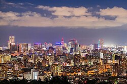 |
1.528.990 | 1.587.889 | ↗ | |
| 7 | Riimibaiken |  |
1.323.229 | 1.315.119 | ↘ | File:Komokata flag.svg Komokata |
| 8 | Riyatoma |  |
922.110 | 1.124.002 | ↗ | |
| 9 | Makkenoke |  |
1.020.992 | 1.115.232 | ↗ | |
| 10 | Illashiya |  |
978.229 | 1.025.220 | ↗ | Otsumirunka |
Demographics
| Demographics of Izaland | |||||||||||||||||||||
|---|---|---|---|---|---|---|---|---|---|---|---|---|---|---|---|---|---|---|---|---|---|
| Demonym | Izaki | ||||||||||||||||||||
| Official languages | Izaki | ||||||||||||||||||||
| Recognized minority languages | Aynu Itak, Konbaki, Eituus | ||||||||||||||||||||
Ethnicities | |||||||||||||||||||||
| |||||||||||||||||||||
Religion | |||||||||||||||||||||
| |||||||||||||||||||||
| Literacy | |||||||||||||||||||||
| Life expectancy | |||||||||||||||||||||
With a population of more than 117 millions of inhabitants, Izaland is a heavily densely populated country (about 385 people per sq km), especially considering that vast inner areas of Kubori island and the north-east are not interested by an intensive urban development. The 92,1 of the population belongs to the Izaki ethnicity, with the remaining 7,9% being immigrants, mostly from Pasundan-Padjadjaran, Wiwaxia and Commonia's countries, and other expats from other countries in Uletha (Belphenia, Kojo, Saikyel). The population of Izaland is largely urban, as the major economic centers since the beginning of industrialization have attracted a large part of the young population from rural areas.
Race
It is difficult to trace a genetic profile of the Izanish race, as since the dawn of time there has been a profound mixture of different ethnic groups, both Uletian and Arcanthic. Physiognomically, Izanish people's face appears to be of an oriental type, with dark hair, black almond-shaped eyes and a slightly pronounced nose. However, there is no lack of genotypes belonging to more Western races, such as lighter colored eyes (ocher, olive green and, very rarely, blue) and hair tending to brown.
Urban planning
A characteristic of the territorial development of Izaki urban centers lies in the fact that, compared to other nations, there are few small isolated villages, while the number of large and medium-sized cities is greater. This is due not only to a greater ease in the distribution of goods, but also to the ancient philosophy of "jiyenchohwashisān" (自然調和思想), or "thought of harmony with nature", drawn up from the 5th century BC by the Taemasa dynasty.
This method of land planning was based on both scientific and astrological criteria, and the positioning of towns and villages was well defined. As the Taemasa dynasty aggregated, through conquests, new territories that had independently developed their regional urban planning, it came, in certain cases, to relocate entire villages, if they did not respect the precepts of the "jiyenchohwashisān".
Although urban planning is still based on modern criteria, the ministry of the environment keeps a careful eye in order to avoid land consumption in the territory.
Major metropolitan areas
In addition to the Greater Sainðaul area (about 23.4 million inhabitants), other noteworthy metropolitan areas are that of Warohan-Eyenniyul (15 million), Panaireki (5.6 million), Kichatsura (3.2 million), Isadashi (2.7 million), Shirukami-Sahnajima (1.7 million), Makkeriya (Riyatoma and Makkenoke, 2.9 million), Sannupuri (2.2 million), Daishin (1.6 million), Ikkashiya-Katayoshi ( 1.7 million) and Reilusahna (1.5 million).
Other towns of some importance are, in no particular order: Atsujīl, Sagoma, Kanlisahna, Muanake, Jinneisoke, Nagareki and Poridake.
Telecommunications
Izaland can count on one of the most advanced communication networks in the world. According to the Ministry of Post and Telecommunications, in 2019 about 97 million people used mobile phones to access the Internet, accounting for about 86% of individual Internet users.
Telephone
- Telephones - main lines in use: 86,7 million (2009)
- Telephone country code: +381
- Telephone - cellular lines in use: 132,2 million (2014)
- Cellular lines prefixes: 020-, 025-, 030-, 035-, 040-
- Mobile operators: Izatel, Its'Izy, Rihtacom
Due to the high ownership of mobile phones, nowadays public telephones are getting rarer and rarer. Izatel, the main fixed line operator started removing most of them since 2015, leaving them only in limited locations.
Internet
About 98,3 million people in Izaland (or 84.0 % of the population) use the Internet. The country has one of the world's fastest average internet connection speed (23,5 Mbps as of 2016), and Gigabit class connections are available in the major cities. Mobile lines 5G availability covers all the prefecture capitals (except for Fudoasamo, in Usmashaki Prefecture), and the 13,5 % of the country as of 2022.
