Barzona: Difference between revisions
m (→Ethnicity) |
|||
| Line 338: | Line 338: | ||
}} | }} | ||
The people of Barzona come from a variety of ancestries. Over half of Barzuna are mestizo, a mix of (Castellanese, Franquese) white with indigenous. White Barzuna people are the second largest ethnic group. Indigenous are found throughout Barzona, the biggest ethnic group is the Edikanana, followed by Taqueza, Yañacuita, Nanquin, Meyfe, Onoyoyo and Itanese. | The people of Barzona come from a variety of ancestries. Over half of Barzuna are mestizo, a mix of (Castellanese, Franquese) white with indigenous. White Barzuna people are the second largest ethnic group. Indigenous are found throughout Barzona, the biggest ethnic group is the Edikanana (commonly known as Yavi after the river), followed by Taqueza, Yañacuita, Nanquin, Meyfe, Onoyoyo (used to be known as Daida, a Yavi term that means angry) and Itanese. | ||
===Language=== | ===Language=== | ||
Revision as of 01:05, 9 April 2022

|
Barzona  Bazona (Taqueza), Batzona (Nahuat), Barzone (Franquese), Barzona (Castellanese, Nanquin), Bazhona (Cubutacubun), Barsuna (Ediyana, Yañatibu), Barsona (Emanapak), Parxona (Meyfe), Parsona (Itanese) Capital: Carante
Population: TBD (2020) Motto: « Terra libre, unita e feliz » Anthem: TBD |
Loading map... |
Barzona, officially the Republic of Barzona is a country in southern Tarephia along the Strait of Lyc. Barzona is comprised of the mainland of Barzona along with two island departments. The capital city is Carante and the most populous city is Barzona. Barzona is divided into 16 departments, two of them are insular (island) departments away from Barzona). Mainland departments are divided into cantons, of which there are 90. Cantons and insular departments are divided into municipalities, there are 684 in Barzona.
Barzona was settled by several indigenous cultures prior to the time of colonization, with advanced civilizations and settlements. The Franquese were the first to colonize what is now Barzona, starting in the 13th century onward. The Castellanese settled Barzona in the 16th century, taking over from the Franquese. Barzona declared independence in 1817 and the entire territory was liberated from Castellanese rule in 1821. Barzona was a part of the Republic of Gran Fojenica (with Allendea) until 1833. Barzona went through a period of civil and military governments for many decades. From 1965 to 1978 Barzona was under a military dictatorship before transitioning to democratic rule.
Barzona is a member of the Assembly of Nations and Tarephian Cooperation Council.
| Republic of Barzona Template:Lang | |||||
|---|---|---|---|---|---|
| |||||
Loading map... | |||||
| Motto: "Terra libre, unita e feliz" A free land, united and happy | |||||
| Capital | Carante | ||||
| Largest city | Barzona | ||||
| Official languages | Barzuna | ||||
| • Regional languages | Franquese, castellanese, various indigenous languages | ||||
| Demonym | Barzuna | ||||
| Government | Constitutional, presidential republic | ||||
| • President | TBD | ||||
| • Vice President | TBD | ||||
| Legislature | Cogreso na Diputados | ||||
| Area | |||||
| • Total | 65405.65 km2 | ||||
| • Water (%) | 14% | ||||
| Population | |||||
| • Estimate (2019) | TBD | ||||
| • Census (2010) | TBD | ||||
| • Density | TBD/km2 TBD/sq mi | ||||
| Timezone | Central Tarephia Standard Time (WUT +1:00) | ||||
| Currency | Lira (BAL) | ||||
| Drives on the | right | ||||
Barzona, officially the Republic of Barzona (Barzonian: Republica na Barzona) is a country located in southwestern Tarephia. It is bordered by Hueyapan to the north, Allendea to the west and Broceliande to the south, as well as Valaga and Tempeira in insular areas. Barzona has a surface area of 56459.24km² (total with territorial waters 66939.56 km²) and a population of ?. The capital city is Carante, and the largest city is Barzona.
Barzona is a diverse country despite its small size, unofficially divided into five regions, costa (the coast), serra (the mountains), selva (the jungle), marca (the march) and insular Barzona. It is ecologically diverse, with a lot of flora and fauna, beaches, mountains and highlands, and dense, humid rainforest. Barzona is a member of the Assembly of Nations and the Tarephia Cooperation Council.
History
The coastal area and coastal-interior regions of Barzona were explored from Broceliande from the 13th century. Probably the first settled area of Barzona by the Rivagiens was the village of Sant-Miquel; the local church was consecrated in 1202. The indigenous people of the area attacked and harassed against the Franqueterre knights exploring the region, who were forced to build castles to defend their areas and became rather limited in their general settlement due to the difficulty in subjugating the indigenous peoples. By the end of the 13th century, the walled towns of Bergantin (ca. 1268) and Barzona (1280) were created to help control trade along the coast, followed by Port-Lis, Iban and Fontanet in the 14th century.
By the early 16th century, they were still limited to a handful of coastal towns, castles and fortresses. In the early 15th century an expedition of knights sailed up the Yavi River in the jungle to explore the area, but were lost and likely died from disease or animals, or were killed by indigenous peoples.
The Castellanese arrived in t1650s, and over the next 40 years were able to subjugate a lot of modern-day Allendea and Barzona, having support from the coastal and lowland caciques for fighting the Franquese, and using their support to cross the mountains and settle them.
Geography
Barzona is divided into four geographic and climactic regions; from east to west are selva (rainforest), serra (mountains), costa (coast) and izulas (islands). Each area has a variety of different flora, fauna.

Yellow-eared parrot

Kinkajou
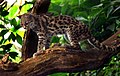
Margay

Torogoz, national bird

Yavi River

Coast in Santa Elena

Forest on Cerro Tauhon

Nictibio grande
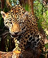
Jaguar

Coast in the island of Grisant (Bussot)

.jpg)

.jpg)


.jpg)


Government and politics
Administrative divisions
The first level subdivisions of Barzona are departments, equivalent to provinces or states elsewhere. Departments are further divided into Cantons, which are themselves comprised of municipalities of various sizes, with one as cantonal seat. Muncipalities are either urban, with a larger town or city, or rural, which can include different villages and localities in one municipality. In Barzona, there are 65 cantons and 279 municipalities. Barzona can also be divided into continental and insular Barzona, continental Barzona being on the Tarephian mainland and insular Barzona comprising of many islands and rocks. Both the insular departments, Bussot and Santa Elena e as Izulas do not have cantons.
| Department | Area (km²) | Population | Capital | |
|---|---|---|---|---|
| Flag | Aurora | 1071.69 | Port-Lis | |
| Flag | Barzona | 4550.78 | Barzona | |
| Caborna | 3194.16 | Caborna | ||
| Flag | Calvet | 3935.40 | Iban | |
 |
Carante | 1778.24 | Carante | |
| Flag | Centro | 3704.44 | Barrigan | |
| Daube | 6140.45 | Pasacana | ||
| Esquibel | 5504.01 | Ferramont | ||
 |
Marca | 8711.09 | Mondier | |
| Niesa | 6940.96 | Niesa | ||
| Flag | Sant-Martin | 8524.03 | Safiza | |
 |
Serrania | 4809.80 | Belmont | |
| Flag | Vianna | 1611.48 | Vianna | |
| Yavi[1] | 12,072.34 | Narvas | ||
| Insular departments | ||||
 |
Bussot | 3194.09[2] | Montfort | |
| Santa Elena e as Izulas | 2313.37[3] | 1181 | Santa Elena | |
International relations
Barzona has relations with several countries.
Economy
Barzona has a mixed economy, with significant policy and sectoral changes from agriculture and raw material extraction to more diversification into new sectors.
Agriculture in Barzona has traditionally centered on various tropical fruits, coffee and chocolate. Fishing is also important in Barzona, primarily along the coasts. Mining, typically for copper and nickel were a big sector in the economy, though that industry has been in decline over the past 30 years. Logging is important economic activity in the jungles of western Barzona. In the last 20 years, tourism has become one of the fastest-growing industries in Barzona.
Businesses in Barzona
One of the most successful businesses of Barzona is Krispy, a fried chicken restaurant chain that originated in Barzona city and is now present nationally. Many businesses in Barzona are from other TCC nations and contribute to the economy.
Demographics and culture
Ethnicity
The people of Barzona come from a variety of ancestries. Over half of Barzuna are mestizo, a mix of (Castellanese, Franquese) white with indigenous. White Barzuna people are the second largest ethnic group. Indigenous are found throughout Barzona, the biggest ethnic group is the Edikanana (commonly known as Yavi after the river), followed by Taqueza, Yañacuita, Nanquin, Meyfe, Onoyoyo (used to be known as Daida, a Yavi term that means angry) and Itanese.
Language
Barzona is a multilingual nation though the Barzuna language is the most widely spoken language in the country and the only official language of the republic. In the past it was considered the language of the peasants and working class, while colonial administrators spoke Castellanese, but since the 18th century has become the main language of Barzona. Towns along parts of the border with Allendea, such as Narvas, Castellanese is spoken and understood due to proximity to Allendea, others like Santa Margarita the Castellanese language is the most common. Franquese is spoken in Bussot, the lingua franca of the island, and a local Franquese-based patois (franquais or patois Sainte-Elenais) is the most common language in Santa Elena.
The traditional largest indigenous language of Barzona is the Taqueza language, spoken though most of the country. The further north you get toward the border with Hueyapán the Taqueza language becomes less prevalent and instead Nawat dialects are more common. In much of Yavi Department (and in neighbouring areas of Allendea), the Ediyana language is spoken by the Edikanana (Yavi) peoples. In western Esquibel department there are divergent Ediyana dialect still spoken by a few indigenous people. The related Yañacuita language is spoken in north and central Yavi department. In the south of the department Onoyoyo is spoken in a few remote communities, which is an isolate language. In Sant-Martin department, Cubutacubun is the most common indigenous language, particularly in the north and west. In the southwest area (Eu Volcan canton) a variety of the Meyfe language spoken in Allendea is spoken. Nanquin is spoken by the indigenous people of the Santa Marta islands, experts don't know the position of the language in linguistics very well, but there are some similarities with the Taqueza languages observed.
Climate
Barzona has a fairly varied though largely warmer climate owing to its geographic location and latitude. Coastal Barzona is fairly warm and humid, but benefits from a see brreze to bring cooler weather. Mountainous areas of Barzona tend to be cooler and often perpetually springlike, with cool-cold winters, though snow is very rare aside from mountain summits. Inner Barzona (Yavi Department) is consistently very hot and humid, characterized by a a fairly rainy summer and a comparatively drier winter.
Climates in Barzona
Military
The Forzas Armadas na Barzona is the armed forces. There are three branches of the military, the army, air force and coast guard. During the dictatorship period, Barzona maintained a well-equipped army, and had air force and navy that lagged behind in alocated funds and resources. Since the 1980s, more of a focus is placed on Barzona's contribution to Lycene and TCC defence, and the government embarked on a program throug the 1990s that eliminated the navy in exchange for better equipped coast guard, and brought more funding to the air force to become a speciality for Barzona.
Army
- Fort militar na Barzona: Army base
- Fort militar na Cornel: Army base, hosts the comandos of Barzona and military academy.
- Fort militar na Pasacana: Military base and large training area in Pasacana.
Air force
- Base aeria na Pinos: Largest air force base, contains fighter and fighter-bomber aircraft, helicopters, transport/cargo aircraft. Is also used by the Federal States Air Force 13th Air Expeditionary Wing.
- Base aeria na Narvas: Along Allendea border on Yavi River, contains a few fighter aircraft and transport and supply helicopters.
- Base aeria na Santa Carolina: Base in Barzona city with fighter and transport units.
- Base aeria Sandrina: Base in the Carante area, has mostly transport aircraft and some fighter-bombers.
Coast guard
- Base na Bergantin: small coast guard base in south east Barzona.
- Base na Barzona: largest base of the coast guard.
Gallery
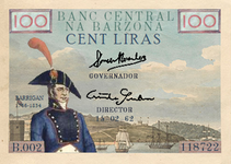
100 lira banknote (Barrigan)
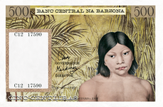
500 lira banknote (Yindis)

1000 lira banknote (TBD)
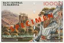
10000 lira banknote (Cornel)
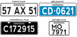
Vehicle registration plate
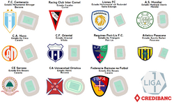
Logos and stadiums of Barzona


Notes and references
- ↑ Yavi was known as Departamento nalla Selva before being renamed on 1 January 2016 after consultation with indigenous peoples of the area.
- ↑ Surface area for the islands, rocks and islets comprising the department totals just 102.4km².
- ↑ Surface area for the islands comprising the department totals just 6.25km².