Collab:Malësoria: Difference between revisions
Bixelkoven (talk | contribs) No edit summary |
Bixelkoven (talk | contribs) m (Updating the project team) |
||
| Line 13: | Line 13: | ||
Current project team: | Current project team: | ||
*[[User:ante44]] | |||
*'''[[User:Bixelkoven]]''' | *'''[[User:Bixelkoven]]''' | ||
* | *[[User:Lithium-Ion]] | ||
*[[User:MiePrzKom]] | *[[User:MiePrzKom]] | ||
*[[User:Rustem Pasha]] | *[[User:Rustem Pasha]] | ||
* | *[[User:stjur]] | ||
*''[[User:sudo91]]'' | |||
<sup>*</sup>Users in ''italic'' are users which formerly edited in the territory and/or didn't create a changeset within the territory in less than 2 months, but are still part of the team. | <sup>*</sup>Users in ''italic'' are users which formerly edited in the territory and/or didn't create a changeset within the territory in less than 2 months, but are still part of the team. | ||
Revision as of 23:21, 18 November 2021
Malësoria, (OGF ID: UL17g), is a country in the southern part of Uletha. It is characterized with diverse ethnicities and cultures, various types of geographical features, and an unique mapping style.
It is an open community collaborative project, meaning you can join at any time if you meet the following requirements for joining, set by the coordinator:
- Have at least 50 changesets/edits
- Have an account at least 3 months old
- Have no history of rule-breaking activities
The owner of the territory and the project coordinator is User:Bixelkoven. If you are interested to join the project, feel free to contact the coordinator here. By joining the project you agree to be active and consistent, whether is it small additions to the map or larger uploads. The coordinator has every right to remove you from the project team, if you enter a period of inactivity, and don't make a changeset within 4 months. After being removed from the team, your edits would be counted as invalid and other members have the right to delete or modify your mapping without your permission.
For territory owners which border Malësoria, they are free to edit 5 km (3 mi) from the border line into Malësoria, if you are not a member of the project.
Current project team:
- User:ante44
- User:Bixelkoven
- User:Lithium-Ion
- User:MiePrzKom
- User:Rustem Pasha
- User:stjur
- User:sudo91
*Users in italic are users which formerly edited in the territory and/or didn't create a changeset within the territory in less than 2 months, but are still part of the team.
**Users in italic and struck-thru are former members which didn't create an edit in under 4 months, a.k.a. the minimal length before being removed from the team.
Click this link to be taken to the map.
Rules

| Rules of the project (detailed overview) |
|---|
|
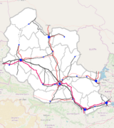
Plan for the nation-wide infrastructure of the country.
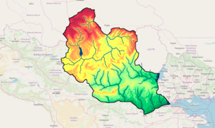
The geography of the country.
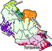
Ethnicities of the country. Light green and light purple are the two groups of Malësorians, Highland Malësorians and Lowland Malësorians respectivelly.


What can you map, and what not

| What can you map, and what not (detailed overview) |
|---|
You can map freely:
You can not map freely (i.e. you should discuss with the community about everything regarding these OR you should follow the plans when mapping these):
|
Sources of inspiration

| Sources of inspiration (brief overview) |
|---|
|
The mapping environment in Malësoria should be rather unique. However, that doesn't mean you should not use real world examples as bases and inspiration. Some which we think may deem useful are (in bold are the main sources of inspiration):
|
Propositions

- Country name:
- Malësoria - User:MiePrzKom
- Tonënia - User:Rustem Pasha
- Atdhe kugurëzohet User:Lithium-Ion
- Capital city name:
- Tëlrasan - User:MiePrzKom
- Vogës - User:Bixelkoven
- Name of the autonomous region:
- Tonënia - User:Rustem Pasha - reused from the country names proposition list
- Names of the mountain ranges:
- Add proposals here...
- Names of the main cities:
- City C1 - Portat e Arta (Golden Gate (al)) - User:Rustem Pasha
- City C2 - Vogës - User:Bixelkoven (reused from the capital city names proposition list)
- City C3 - Tekinhane Veriore (Northern Sanctuary (tr/al)) - User:Rustem Pasha
- City C4 - Bicajzë - User:MiePrzKom
- City C5 - n/a
- City C6 - Aibashjamvë (originally Aibaŝamwa) - User:Sudo90
- Names of the main lakes:
- Liqeni i Bashelezit - User:MiePrzKom
See also: Collab:Malësoria/Lists