Collab talk:Federal States/Collaborative States/Cosperica
Pre-assignment discussion
Well, I am interested!--Happy mapping and God bleses you, ZK (talk) 01:01, 3 May 2018 (CEST)
To add on, the state's geography is somewhat similar to Singkangia, so I would like to collaborate and learn from this.--Happy mapping and God bleses you, ZK (talk) 06:06, 3 May 2018 (CEST)
- Hi, Zhenkang! As you mentioned in your sandbox, Singkangia is like Singapore and Johor. And as mentioned in AR120-84 page, the state is like California. I dont know if there are beaches, deserts and canyons in Singapore and around. So, I believe there is nothing similar Singkangia and AR120-84 geography. Anyway, I am happy you said you would like to learn more. I dont want to look like a stupid guy, but please, stop comparing and relating everything to Singkangia and Singapore. Its a chance to you create different things! hehe. Good luck as collaborator in AR120-84! -- BMSOUZA (talk) 14:55, 3 May 2018 (CEST)
I understand. Forget about the compasrison. But I wish to join this project to gain a new experience of mapping non-tropical nations.--Happy mapping and God bleses you, ZK (talk) 02:19, 4 May 2018 (CEST)
By the way I will not get too involve in the wiki stuff, due to 'sanctions' placed on my wiki quota.--Happy mapping and God bleses you, ZK (talk) 04:18, 4 May 2018 (CEST)
I am extremely interested in contributing, as I know the area you are referencing like the back of my hand. --Geoboi (talk) 05:55, 3 May 2018 (CEST)
I'm interested too in this project, also I have to say that I'm spanish, so I can put a lot of good names of places and rivers etc. in Spanish, bc this state is going to be like Southern California, and there are a lot of Spanish names in this zone. If you want, I can make detailed city zones with Spanish names. --Rekant (talk) 20:07, 16 May 2018 (CEST)
I'm not sure if you want a retard like me, but just so you know, I'm interested... --Andrepoiy (talk) 14:42, 24 July 2018 (CEST)
Hello, I am really interested in joining this project, I hope I can contribute in helping make interesting map of the State of Cosperica. I have long interest in California area but sadly I can't speak Spanish that well, so probably I'll be helping in making buildings and contributing on making basic infrastructure. Thank you. --oneofbeatlefan (talk) 21:53, 26 July 2018 (CEST)
Late to the party, but interested in joining. I don't know but I might help detail some rivers, make small creeks, etc. JayPlaysBeamNG (talk) 00:58, 5 August 2018 (CEST)
- You're all welcome to pick up a project: Collab:Federal States/Collaborative States/Cosperica#Active projects /wangi (talk) 02:56, 30 July 2018 (CEST)
Collaboration framework
Discussion to establish how this collaborative state will be developed: Collab_talk:Federal States/Collaborative States/Cosperica/Collaboration framework. /wangi (talk)
Natural feature projects
For any questions regarding the natural features projects. /wangi (talk) 02:07, 24 July 2018 (CEST)
- I would like to adopt the river task AR120-84-NF-06 at DM, DN.
Is the task limited to the pristine river or should things like making it a navigable waterway or neighboring farmland be considered too?--Oxalia (talk) 10:34, 24 July 2018 (CEST) - Should the ghosted barrow river be deleted (or used to make new rivers)?--Oxalia (talk) 11:17, 24 July 2018 (CEST)
- Hello, I would like to request to do AR120-84-NF-08 rivers and coastal features. Do I need to give you the sketch draft of the rivers? Thank you. oneofbeatlefan (talk) 20:56, 2 August 2018 (CEST)
- Just asking, is there any plan to do Grand Canyon like features in Cosperica? I think that would be interesting but very advanced. --oneofbeatlefan (talk) 20:01, 12 August 2018 (CEST)
Yes, the NF-05 Rio del Cañon project. /wangi (talk) 21:21, 11 August 2018 (CEST)
Natural feature projects - Climate
Rekant is kindly working on the AR120-84-NF-01 project to come up with a climate map for the state. I've moved the discussion here, from the earlier talk page. Hopefully those knowledgable in this sort of thing can add in their feedback, i'm a bit lost.
The climate is going to be similar to Southern California, so the following are good references for the relevant Köppen climate classifications:
I've created a GIF to overlay the topology & proposed climate:
Thanks/wangi (talk) 01:34, 30 July 2018 (CEST)
| Proposal | Map | Description |
|---|---|---|
| 1 | File:Climate AR120-84 map2.png | Rekant draft 2 |
| 2 | File:Cosperica Climate Aiki1.svg | I'm far from being 100% sure, but here is a first draft (click to enlarge) of what could be the Cosperican climates. --Aiki (talk) 21:20, 2 August 2018 (CEST) |
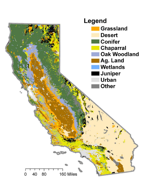
| 3 | File:Ar120-84-landcover-isleno.png | My suggestion would be to focus on landcover rather than climate, which would be simpler for most people to follow and use in their mapping. Here's a sketch based on this map, showing chaparral lands along the coast, forests (juniper/conifer/oak) at the higher elevations, deserts in the interior areas, and grassland (mostly developed into farmland) in the Central Valley. --Isleño (talk) 04:09, 3 August 2018 (CEST) |
Thanks for the further submissions! Have spent a lot of time reading up on sub-ecoregions and climatic regions... The wider range of regions used:
- AW - tropical wet and dry
- BSh - Hot semi-arid
- BSk - Cold semi-arid
- BWh - Hot desert
- BWk - Cold desert
- Cfc - Subpolar oceanic
- Csa - Hot-summer Mediterranean
- Csb - Warm-summer Mediterranean
- Csc - Cold-summer Mediterranean
- Dsb - Humid dry cool continental
Lot more to think about, but do like the simplicity of the ecoregions. /wangi (talk) 02:26, 4 August 2018 (CEST)
- I agree with Isleño's comment, land cover could be easier to follow for most people. Just pay attention to the endorheic depressions you drew inland where the weather is likely to be hotter and dryer than in the surroundings areas with little to no vegetation, a bit like Death Valley. --Aiki (talk) 18:39, 12 August 2018 (CEST)
- Where do you see endorheic depressions? Is there a more detailed elevation model somewhere?--Oxalia (talk) 19:50, 12 August 2018 (CEST)
- See the NF-09 project on the page. /wangi (talk) 19:55, 12 August 2018 (CEST)
- Now I see it too 🙈 --Oxalia (talk) 19:58, 12 August 2018 (CEST)
- Indeed. You have also a small one North of NF-09 and a bigger one to the East, though it may be drained toward the neighbouring state. I can't see if the depression stopped before the border. --Aiki (talk) 16:48, 13 August 2018 (CEST)
- Now I see it too 🙈 --Oxalia (talk) 19:58, 12 August 2018 (CEST)
- See the NF-09 project on the page. /wangi (talk) 19:55, 12 August 2018 (CEST)
- Where do you see endorheic depressions? Is there a more detailed elevation model somewhere?--Oxalia (talk) 19:50, 12 August 2018 (CEST)
State flag
For submissions of state flag proposals. Consider these the "long list" before the official submissions open at Collab:Federal States/Archive#Western collaborative state (AR120-84). An opportunity to put forward ideas, the whys and experiment! /wangi (talk) 00:43, 2 August 2018 (CEST)
| Proposal | Flag | Description |
|---|---|---|
| 1 | File:Cosperica Flag 01.png | The orange represents the desert, blue is the sea, and white the sky, and the sun in the middle represents life and prosperity. --Rekant (talk) 10:58, 30 May 2018 (CEST) |
| 2 | 
|
The flag (ratio 2:3) is highly inspired by the Flag of New Mexico: same "Spanish" colours but inverted with an indigenous solar symbol, here a 24-ray sun (actually, letters Pi set along a circle). --Aiki (talk) 23:13, 30 July 2018 (CEST) |
| 5 | File:Cosperica-flag-opt5.png | The flag (ratio 2:3) is inspired by the colours of the Castellán flag (original colonisation) and the arrow of the Federal States flag, but pointing west (later expansion westward of the FSA) /wangi (talk) 00:32, 2 August 2018 (CEST) |
| 6 | File:CospericaFlagProposal.png | The flag (ratio 8:12) is inspired by the colours of the Castellán flag, with the wavy middle stripe representing the ocean, and the sun representing prosperity. --Geoboi (talk) 07:53, 13 August 2018 (CEST) |
May I ask why 3 and 4 were removed? I know they were your submissions, but I'm just wondering. Talk to Rhiney boi 01:41, 28 June 2019 (CEST)
- Just that I wouldn't want them to be considered any more - they were thoughts along the way to 5. /wangi (talk) 02:12, 28 June 2019 (CEST)
Indigenous people population centres
Indigenous people population centres - where, why? Discuss. Keep in mind the climate & topology. /wangi (talk) 02:42, 30 July 2018 (CEST)
Maybe, native tribes (like navajos) will live in desertic zones with a few rivers going through them, like in the real USA, many of the tribes are settled in southern Arizona and California, where the weather is hotter --Rekant (talk) 09:52, 30 May 2018 (CEST)
The real world Tongva tribes are living in the Los Angeles Basin, probably because it's the flattest land in the area has a river flowing through it and suitable for small farming and fishing. To be implemented in Cosperica, the native people population centers are around the delta of Barrow River, plenty of rivers around, good for farming and on a bay which is also good for fishing because the waters are quite. --oneofbeatlefan (talk) 13:55, 5 August 2018 (CEST
- Is anyone able to summarise the features apparent today in southern California, which related to the earlier indigenous population? What is the legacy? /wangi (talk) 00:39, 6 August 2018 (CEST)
- Although I am not from southern California, I already googled some info and read a few articles about the earlier indigenous population. US governments also recognized around 18 sovereign American Indian tribal government in SoCal. While most of the American Indian reservations are located around San Diego County, the location of reservations are very scattered. In San Diego County, most of the reservations are located within the mountains, not far from the sea which isn't very desert-ish. So, One tribe has only one reservation land and the sovereign government there. And the locations of reservation land could be only a very small part of what they have before the European Colonization. --oneofbeatlefan (talk) 15:33 7 August 2018 (CEST)
- Thanks, interesting. Also had a read of Indigenous peoples of California. IT would be great to have something along those liens for Cosperica. /wangi (talk) 23:48, 7 August 2018 (CEST)
Namebank(o)
We're going to need a lot of inspiration for naming features, and initially a lot if those names will be in Castellanese/Spanish... Please add below; explanations welcome, but not mandatory. /wangi (talk) 01:30, 16 August 2018 (CEST)
- To get things started i have already used variations of below:
- Santa Rosa (de Septiembre) {indirectly via two vote results}
- Rio de Septiembre
- Sasepcro {via Sansepolcro vote submission}
- Mission (La Mision) {from vote results}
- Rio Noramira {from vote results}
- Horno del Diablo {from talk}
- Cuenca Morte
- Valle Quemado {from talk}
- Rio del Cañon
- Caldero
- Kronkyte {existing, tie into Klondyke?}
- Barrow {existing}
- (Santa Maria de la) Esperanza {from vote results}
- Mojaca
- Santa Rosa (de Septiembre) {indirectly via two vote results}
Zytik Suggestions
- Acatiganulpa
- Aditoriana
- Alote
- Azañe
- Bacalar
- Balacarte
- Bantan
- Bazacolle
- Belitare
- Beyano
- Bitisota
- Calarero
- Canolana
- Conaskite
- Conuska
- Cuyote
- Dalitiz
- Dejoñes
- Elamalitanana
- Facalane
- Faprotan
- Faquestes
- Gaja
- Galimaz
- Gelis
- Gonzagiña
- Hacayone
- Haceste
- Henitelisa
- Heuña
- Husita
- Huyicalite
- Iñitar
- Javito
- Lacaneño
- Laganaz
- Lesa
- Leyasoña
- Moneñaz
- Quenesa
- Rio de Nasa
- Rio de Doir
- Rio de Rosalaz
- ....more (TBD)
/wangi (talk) 01:49, 16 August 2018 (CEST)
What if we build a bay with some cities? Like San Francisco Bay Area, in all the bay there are Saints names, Mateo, Jose, Francisco, Bruno, Pablo. So we can make an area also dedicated to Saints: San Rafael, San Roberto, San Eduardo, San Fernando..., Santa Marta, Santa Raquel, Santa Helena...--Rekant (talk) 17:47, 18 August 2018 (CEST)
- I've created a bank of people to draw inspiration from: Collab:Federal States/Collaborative States/Cosperica/Notable people. /wangi (talk) 03:42, 5 September 2018 (CEST)
Presidios, Pueblos, Missions, Ranchos
http://vm136.lib.berkeley.edu/EART/rancho.html?rel=outbound
The colonization of California began with the Spanish Empire's discovery of New Spain. Along with Mexico, the states of Texas, Arizona, New Mexico, California, and other lands, made up what was once known as New Spain.
California was one of the last of these Spanish territories to be occupied. The first Spanish colony to be established in California was the mission and presidio at San Diego. From this first settlement, the Spanish and Mexican governments founded four presidios, four pueblos, and 21 Catholic missions, along with granting vast amounts of rancho lands to private individuals.
When talking about this early Spanish California, the missions, pueblos, and presidios are invariably remembered. Almost everyone has visited or read about the old town or pueblo of San Diego, the missions at Santa Barbara or Monterey, the presidio at San Francisco, and the pueblo of Los Angeles. These places have become famous historical landmarks. The remnants of these landmarks at San Diego, San Francisco, and other cities. are real: they are places we can identify with because of their physical presence. These are objects we can see and touch and visit on vacations or holidays: a living history lesson. It is much easier to conjure up the picture of Franciscan monks or Spanish soldiers when we are standing inside the missions or presidios.
One segment of this pastoral era of California history, which is not as easily remembered, is the Spanish and Mexican ranchos. These ranchos, at one time, covered some of the most fertile land in California. To say that the cities of Pasadena, Huntington Beach, San Clemente, Oakland, and many others, are on land once part of a Spanish land grant is a historical statement. This, however, is not a statement verifiable by the present reality. We cannot stand in downtown Pasadena and physically touch or see the old ranchos. There is no visible evidence of these large ranchos with their adobe houses. Consequently, they have become the almost forgotten portion of California's pastoral era.
Whatever brings to mind these early Spanish influences, it must be remembered that a majority of the fertile land in California, at one time, was influenced by this Spanish legacy. Land title problems can still be traced back to the government patents for these lands. An awareness of California history might entail the solving or reassessment of land title problems in particular situations.
I would like to map a similar sort of situation out initially in Cosperica, to guide later development. Any thoughts? /wangi (talk) 01:36, 1 July 2019 (CEST)