Deodeca: Difference between revisions
No edit summary |
|||
| Line 241: | Line 241: | ||
===Symbols=== | ===Symbols=== | ||
<gallery> | |||
8-Point-Star black.svg|The Deodecan eight-point star | |||
American Bison .jpg|Deodecan Bison | |||
ColumbiarivergorgeJRH.jpg|Odeka River | |||
</gallery> | |||
===Literature=== | ===Literature=== | ||
Revision as of 01:27, 19 March 2023
 This encyclopedia article is about the country in Archanta. You may be looking for the collaboration page.
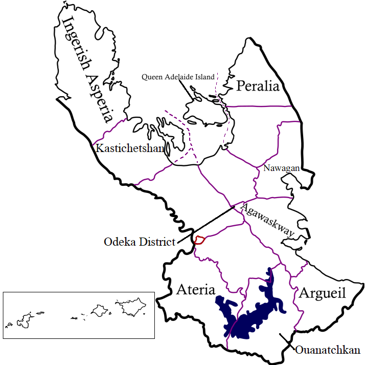
Deodeca, officially the Commonwealth of Deodeca is a sovereign country in southern Archanta. It consists of 12 provinces that span 685,000 square kilometres (264,000 square miles), making it one of the largest countries in the world. It borders Ardencia and the FSA to the east and south-east, Ambrosia to the southwest, and AR043 to the west. The capital is TBD, and its largest city is TBD. The Ambrosian exclave of Upper Crown (Haute Couronne)∈⊾ sits between the Deodecan provinces of AR060-3 and AR060-4. Deodeca is a member of the Ingerish Commonwealth, having gained independence from Ingerland in UNKNOWN YEAR. It is also a member of the Assembly of Nations.
Etymology
History
Pre-Ulethan History
Deodecan Colonies
Clamash Purchase
Modern History
Geography
Deodeca has vast and varied geography that covers a large portion of western Astrasia. Deodeca has extensive maritime borders that extend into the "Sea of Deodeca" and some of the Grand Lakes (Lake Amanecer and Lake Betaouais), giving it a large EEZ.
Climate
Northern Deodeca sits mainly within the Cfa and Cfb climate ranges in the north. These provinces are most susceptible to thunderstorms and strong ocean winds. Ingerish Asperia's western coast is most prone to these seaborne storms and breezes due to its position on the Asperic northward current, and is the wettest part of the country. Areas east of (insert name of mountain range), such as eastern Ingerish Asperia and Kastichetshan, receive lower precipitation due to the rain shadow.
As for Southern Deodeca, its distance from the ocean guarantees a mostly continental climate (primarily Dfa and Dfb). However, the number of large lakes allows for a more humid climate in these regions, further enabling the lush temperate to boreal forests that dominate the southern half of the country. Lake-effect snowfall is especially high on eastern shores of Lake Ouanatchkan, as well as in limited amounts along lakes Betaouais and Amanecer.
Hydrology
Deodeca's abundance of water resources is due to its density of water networks. Deodeca has over 200 major rivers. Major rivers include Ingerish Asperia's River Agnes and Umbra River, Peralia's Jersey River, Agawaskway's Frontenac River, Ouanatchkan's Edrange River, and above all, the Odeka River, which bisects the entire nation. The lakes of Deodeca are an important resource, both economically and environmentally. Lake Ouanatchkan, Lake Betaouais, and Lake Amanecer are among the most important and largest lakes in Deodeca. These contribute to inland Deodeca's moderated climate and provide water resources for humans and the environment.
Biodiversity
Government and Politics
Law
Foreign relations and military
Subdivisions

| Flag | Name | Coat of arms | Code | Capital City | Largest City | Population | Total Area in km² (mi²) | Land Area in km² (mi²) | Map |
|---|---|---|---|---|---|---|---|---|---|
| Agawaskway | AW | Kingstown | Kingstown | 8,500,000 | 46,134.08 (17,812.47) | 37,726.49 (14,566.28) | Map∈⊾ | ||
| Argueil | 
|
AG | Liernase | Liernase | 41,977.52 (16207.61) | TBD (TBD) | Map∈⊾ | ||
| Ateria | AT | Glenburn | Glenburn | 7,926,000 | 56,002.26 (21,622.59) | 52,108.68 (21663.68) | Map∈⊾ | ||
| Ingerish Asperia | 
|
IA | New Reydon | Stonesipher | 10,100,550 | 126,605.94 (48,882.83) | 99,884.22 (38,565.51) | Map∈⊾ | |
| Kastichetshan | KT | TBD | Coalburne | TBD | Map∈⊾ | ||||
| Nawagan | NW | Wadeville | Fayette | 5,300,000 | Ex | Ex | Map∈⊾ | ||
| Odeka District | OD | Stradworth | Stradworth | TBD | Map∈⊾ | ||||
| Ouanatchkan | OA | TBD | Audeville | 3-4 million | Map∈⊾ | ||||
| Peralia | 
|
PE | Creswick | Creswick | 7,228,361 | 49,330.44 (19,046.59) | 43,287.75 (16,713.49) | Map∈⊾ | |
| Queen Adelaide Island | QAI | Lamington | Lamington | 956,000 | 27,206 (10,504) | 11,935 (4,608) | Map∈⊾ | ||
| Example | Ex | Exampleville | Exampleville | Ex | Ex | Ex | Map∈⊾ |


