Forum:Global and regional issues/Attempts at an exploration of the Vinn Sea :): Difference between revisions
(Created page with "<div class="forumheader" style="margin: 1; background-color: #eeeeee; text-align: left; padding: 5px;">'''Forums → Forum:Global and regional issues|Glob...") |
m (Corrected spelling and stuff) |
||
| Line 7: | Line 7: | ||
First, I know I’m nerding too much here. But: | First, I know I’m nerding too much here. But: | ||
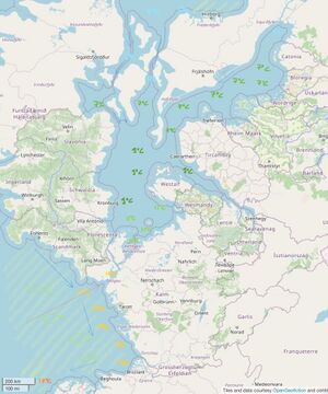
I am currently taking a course in oceanography at uni, even though it has nothing to do with my major. So, I thinking about the climate of the Vinn Sea area, where my territory is. Obviously, trying to actually model all of OGF’s oceanic currents would be an absurd amount of work to reach an absurdly small level of precision, but the ocean that feeds into the Vinn sea is really similar in shape, latitude, connexion with ocean ocean basins, etc., with the North Atlantic, so it makes it easier to have sort of a less vague idea. Rather than mapping the currents, which, apart from the broad idea of what the currents are doing — something on which we all seem to agree —, would depend too much on the precise shape of the coasts, etc., for me to be able to do anything useful, I’ve chosen to go with water temperature, slightly tweaked by my new-found knowledge of ocean mechanics ( ;) ). In practice, I extrapolated from [https://www.seatemperature.org/ this map]. Here are the results, including light coloured arrows to figure where the currents should be. | I am currently taking a course in oceanography at uni, even though it has nothing to do with my major. So, I thinking about the climate of the Vinn Sea area, where my territory is. Obviously, trying to actually model all of OGF’s oceanic currents would be an absurd amount of work to reach an absurdly small level of precision, but the ocean that feeds into the Vinn sea is really similar in shape, latitude, connexion with ocean ocean basins, etc., with the North Atlantic, so it makes it easier to have sort of a less vague idea. Rather than mapping the currents, which, apart from the broad idea of what the currents are doing — something on which we all seem to agree —, would depend too much on the precise shape of the coasts, etc., for me to be able to do anything useful, I’ve chosen to go with water temperature, slightly tweaked by my new-found knowledge of ocean mechanics ( ;) ). In practice, I extrapolated from [https://www.seatemperature.org/ this map]. Here are the results, including light coloured arrows to figure where the currents should be, and an area hatched in light green to show a zone of upwelling (expect loads of fish there :) ). | ||
[[File:Temperature map Vinn sea.jpg|thumb]] | [[File:Temperature map Vinn sea.jpg|thumb]] | ||
Latest revision as of 18:41, 11 March 2023
Hi!
First, I know I’m nerding too much here. But:
I am currently taking a course in oceanography at uni, even though it has nothing to do with my major. So, I thinking about the climate of the Vinn Sea area, where my territory is. Obviously, trying to actually model all of OGF’s oceanic currents would be an absurd amount of work to reach an absurdly small level of precision, but the ocean that feeds into the Vinn sea is really similar in shape, latitude, connexion with ocean ocean basins, etc., with the North Atlantic, so it makes it easier to have sort of a less vague idea. Rather than mapping the currents, which, apart from the broad idea of what the currents are doing — something on which we all seem to agree —, would depend too much on the precise shape of the coasts, etc., for me to be able to do anything useful, I’ve chosen to go with water temperature, slightly tweaked by my new-found knowledge of ocean mechanics ( ;) ). In practice, I extrapolated from this map. Here are the results, including light coloured arrows to figure where the currents should be, and an area hatched in light green to show a zone of upwelling (expect loads of fish there :) ).
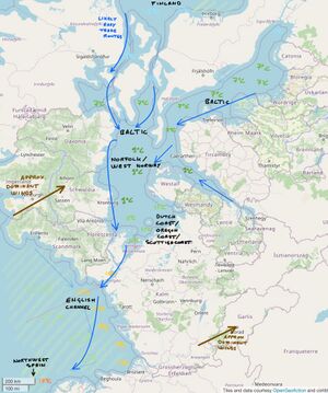
Then, I’ve added descriptors, in the form of names of areas on Earth where the sea is at a similar temperature, for me to make sense of it, as well as arrows describing how the currents flow along the coasts (ie., possible good trade routes), and an arrow describing the main direction of the prevailing winds to expect in the area. I’m not sure how useful it is, but it was fun to do. (See the second image).
Overall, I’m definitely going to use this to improve the way I see the climate in my territory, but I don’t know if anyone else will find it useful. And, although I would have loved it if all our territories were accurate in terms of climate and things, I know that isn’t the case (although more so in the Vinn sea area, perhaps) and I don’t expect anyone to be angry at what I’m doing here because I’m not trying to impose this upon anyone :)
On the other hand, if other people have interesting things to say about realistic geography in the area, you’re very much welcome to do so!

