Forum:Global and regional issues/Lycene Geology: Difference between revisions
(Created page with "<div class="forumheader" style="margin: 1; background-color: #eeeeee; text-align: left; padding: 5px;">'''Forums → Forum:Global and regional issues|Glob...") |
(Start forum discussion with drafts) |
||
| Line 7: | Line 7: | ||
Thank you for your cooperation & happy mapping. --[[User:Aiki|Aiki]] ([[User talk:Aiki|talk]]) 14:26, 12 March 2023 (UTC) | Thank you for your cooperation & happy mapping. --[[User:Aiki|Aiki]] ([[User talk:Aiki|talk]]) 14:26, 12 March 2023 (UTC) | ||
=Aiki's drafts 2023-03-12= | |||
Following a short discussion outside this Wiki forum, I have tried to gather some of the elements that were presented by various mappers and combined them on a map with additional and already known natural features (e.g. mountain ranges). | |||
==Fault lines== | |||
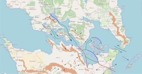
[[File:Lycene Geology AikiProp.svg|500px|thumb|right|Fault lines in the strait of lyc]] | |||
* Mountains in Freedemia are rather high with their highest point at about 5,000m. IRL, most similar cases are either due to subduction (e.g. Andes) or continental collision (e.g Alps, Himalayas). Ruwenzori Mountains (Rift edge massif reaching 5,109m) are only 120km long. I'm not sure we can use it as an example for this region can make the sea off Freedemia a rift. | |||
* Barzona mountains are doted with many volcanoes. Volcanoes are also present in Marize and Yusia | |||
* Large mountain ranges in northern Antarephia and southern Tarephia are roughly parallel, oriented NW/SW. This may be interpreted as some kind of compression/collision. | |||
Given these elements here's a potential interpretation: | |||
* On the map to the right, brown is for main mountain ranges, arrows are for plate movements, blue for subduction, green for transform faults (plates are sliding, relatively to one another), red for divergent boundary and purple is for continental collision. | |||
* Antarephia is rotating clockwise, the east is moving SW away from Tarephia while its western portion is moving NE nearer to Tarephia | |||
* Northeastern Antarephian peninsula (where San Marcos is located) is moving away from the rest of the continent, mostly in a eastward movement, creating a fold on which the "Garonan" archipelago sits. | |||
* The large-island archipelago in the west basin is sliding SE while being compressed by Antarephia against Tarephia. | |||
* More to the north, Barzona is closing an oceanic remnant, causing it to dive under Barzona, creating volcanic activity in the mountain range (also due to the subduction. | |||
* The eastern and southern basins have a complex series of oceanic extension and subduction: the southern basin is extending and its eastern part dives under another extending oceanic basin, surrounding by strings of islands. | |||
In terms of impacts: | |||
* Blue lines and green lines are the most likely to create earthquakes, depending on the type of rocks. For the blues, they might even create tsunamis as one plate suddenly slides under the other, lowering the water column. | |||
* Depending on the angle, blues lines may create ''explosive'' volcanoes. | |||
* Red lines may create a graben with horst (valley with steep edges) with a without volcanic activity. They may also correspond to a oceanic ridge with each edge moving away. --[[User:Aiki|Aiki]] ([[User talk:Aiki|talk]]) 15:30, 12 March 2023 (UTC) | |||
==Plates== | |||
[[File:Lycene Geology Plates AikiProp.svg|500px|thumb|right|Main tectonic plates in the Strait of Lyc]] | |||
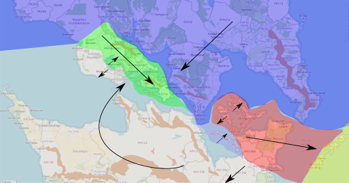
Given the elements exposed in the previous section, the map to the right displays potential tectonic plates for the Lycene region and their general direction: | |||
* The Antarephian Plate (light grey) is rotating clockwise, vaguely around the Strait of Lyc (in its narrow sense). South of the strait, it's moving away from Tarephia while north of it, it's colliding against it. | |||
* The unnamed green plate is moving SE with a light clockwise rotation. Its NE edge is swallowing the rest of an ancient ocean while its SE portion is being compressed by Antarephia against Tarephia. | |||
* Two smaller plates are displayed: | |||
** The smallest (purple) is extending away from Antarephia while being quickly subdued by the red plate. | |||
** The red plate has two main feature: the general eastward movement and its extension in its western section. | |||
* The Tarephian Plate is depicted in blue. | |||
* The Asperic Plate depicted in yellow may be replaced by the Tarephian or Antarephian plate in that region, the plates' limits being moved further east. --[[User:Aiki|Aiki]] ([[User talk:Aiki|talk]]) 15:30, 12 March 2023 (UTC) | |||
Revision as of 15:30, 12 March 2023
Dear Tarephians & Antarephians,
As our continents share a long and narrow interface along the Strait of Lyc, this forum entry is dedicated to building a common and somehow consistent geology for this region. Given our amateur knowledge - for the vast majority of us, I suppose - and the amount of territories still unowned or insufficiently mapped, it's highly unsure we will reach a theory that makes 100% sense. Some room should also be left for future adjustments, whether due to new owners or changes in existing countries.
Thank you for your cooperation & happy mapping. --Aiki (talk) 14:26, 12 March 2023 (UTC)
Aiki's drafts 2023-03-12
Following a short discussion outside this Wiki forum, I have tried to gather some of the elements that were presented by various mappers and combined them on a map with additional and already known natural features (e.g. mountain ranges).
Fault lines
- Mountains in Freedemia are rather high with their highest point at about 5,000m. IRL, most similar cases are either due to subduction (e.g. Andes) or continental collision (e.g Alps, Himalayas). Ruwenzori Mountains (Rift edge massif reaching 5,109m) are only 120km long. I'm not sure we can use it as an example for this region can make the sea off Freedemia a rift.
- Barzona mountains are doted with many volcanoes. Volcanoes are also present in Marize and Yusia
- Large mountain ranges in northern Antarephia and southern Tarephia are roughly parallel, oriented NW/SW. This may be interpreted as some kind of compression/collision.
Given these elements here's a potential interpretation:
- On the map to the right, brown is for main mountain ranges, arrows are for plate movements, blue for subduction, green for transform faults (plates are sliding, relatively to one another), red for divergent boundary and purple is for continental collision.
- Antarephia is rotating clockwise, the east is moving SW away from Tarephia while its western portion is moving NE nearer to Tarephia
- Northeastern Antarephian peninsula (where San Marcos is located) is moving away from the rest of the continent, mostly in a eastward movement, creating a fold on which the "Garonan" archipelago sits.
- The large-island archipelago in the west basin is sliding SE while being compressed by Antarephia against Tarephia.
- More to the north, Barzona is closing an oceanic remnant, causing it to dive under Barzona, creating volcanic activity in the mountain range (also due to the subduction.
- The eastern and southern basins have a complex series of oceanic extension and subduction: the southern basin is extending and its eastern part dives under another extending oceanic basin, surrounding by strings of islands.
In terms of impacts:
- Blue lines and green lines are the most likely to create earthquakes, depending on the type of rocks. For the blues, they might even create tsunamis as one plate suddenly slides under the other, lowering the water column.
- Depending on the angle, blues lines may create explosive volcanoes.
- Red lines may create a graben with horst (valley with steep edges) with a without volcanic activity. They may also correspond to a oceanic ridge with each edge moving away. --Aiki (talk) 15:30, 12 March 2023 (UTC)
Plates
Given the elements exposed in the previous section, the map to the right displays potential tectonic plates for the Lycene region and their general direction:
- The Antarephian Plate (light grey) is rotating clockwise, vaguely around the Strait of Lyc (in its narrow sense). South of the strait, it's moving away from Tarephia while north of it, it's colliding against it.
- The unnamed green plate is moving SE with a light clockwise rotation. Its NE edge is swallowing the rest of an ancient ocean while its SE portion is being compressed by Antarephia against Tarephia.
- Two smaller plates are displayed:
- The smallest (purple) is extending away from Antarephia while being quickly subdued by the red plate.
- The red plate has two main feature: the general eastward movement and its extension in its western section.
- The Tarephian Plate is depicted in blue.
- The Asperic Plate depicted in yellow may be replaced by the Tarephian or Antarephian plate in that region, the plates' limits being moved further east. --Aiki (talk) 15:30, 12 March 2023 (UTC)

