Weekly site maintenance is scheduled Thursday 04:00–06:00 UTC.
Editing will not be possible during this time, and there may be other brief disruptions. (additional info)
Forum:Ingerland/Introduction to the project: Difference between revisions
(Added a comment) |
|||
| Line 145: | Line 145: | ||
{| | {| | ||
|- | |- | ||
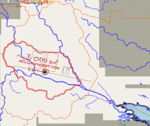
| style="background:#f5fbff; border:1px solid #80d0ff; padding:1em; margin:auto;" | At first, I would like to point out the suggested size for the capital. It will, of course, depend on how many people will live in Ingerland proper. If we take the population density of IRL UK (270/sq.km), Ingerland would have 139 mln. people. Although, I doubt that such population density is possible at such high latitudes, nor it can be as low as Scottish (67/sq.km). For my calculations down below, I took the population density of 150/sq.km. and got the supposed population of Ingerland at | | style="background:#f5fbff; border:1px solid #80d0ff; padding:1em; margin:auto;" | At first, I would like to point out the suggested size for the capital. It will, of course, depend on how many people will live in Ingerland proper. If we take the population density of IRL UK (270/sq.km), Ingerland would have 139 mln. people. Although, I doubt that such population density is possible at such high latitudes, nor it can be as low as Scottish (67/sq.km). For my calculations down below, I took the population density of 150/sq.km. and got the supposed population of Ingerland at 77 310 000. (UK has 67 mln) | ||
Whatever the case, we probably should keep the population density of Winburgh ''(I would also like to keep the same name; there are myriads of objects all around OGF named after Winburgh)'' around the same as London ( | Whatever the case, we probably should keep the population density of Winburgh ''(I would also like to keep the same name; there are myriads of objects all around OGF named after Winburgh)'' around the same as London (5500-6000 per sq.km.) and the city area may accomodate 1500-2000 sq.km in total. | ||
[[File:Ingerland sudo91 1.png|none|thumb|300x300px|The agglomeration]] | [[File:Ingerland sudo91 1.png|none|thumb|300x300px|The agglomeration]] | ||
Revision as of 21:22, 8 May 2023
Prelude
Ingerland is a country in northwestern West Uletha and is the homeland of the OGF equivalent of the English language and culture. The main parallel to Ingerland is England, not the United Kingdom. Like England, Ingerland is a major historical colonial power which has influenced a immense amount of the OGF world, in every corner of the world. Because of that, Ingerland can be considered one of the most important countries for OGF's in-universe history. This forum page should help all interested people meet at one place to discuss everything about Ingerland in-world, from geography and geology, to infrastructure and beyond. Should it be necessary or easier, discussions will be broken out into subforums.
| IMPORTANT NOTE: Territory applications will not be approved without considering the national plans which are discussed below. |
Timeline
- Now: Discussion of critical points below begins; former colonies begin submitting a priority list of toponyms and monarchs to include in the project
- 01 May: Users may begin applying for a region of Ingerland, but no applications will be approved prior to 10 May to allow for initial discussions; active applicants will be given priority in the decision-making process over the broader community.
- No later than 10 May: Final decisions on outline of geology, hydrology, and topography
- 25 May: Input from former colonies ends
Discussion
Geology, Hydrology, and Topography
This will be the most important part for starting up the project. A well planned geography of a nation opens doors to a lot of things in the later stages of the project. Send in your suggestions, preferably using pictures and discuss!
There are certain aspects of the national geography that are already set in place:
|
User proposals
Yuanls' proposal
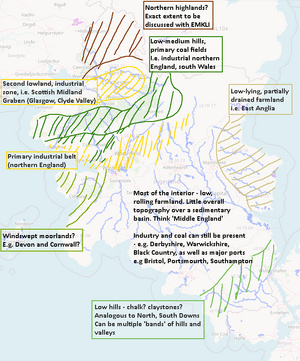
In light of the above discussions, and established geographical context (from neighbouring countries and the existing hydrology), I've produced a rudimentary geomorphological/geological/geographical map of Ingerland. I've designed it to provide a realistic, comprehensive and balanced interpretation of what Ingerland could look like. Please let me know your thoughts on this draft, and what could be added/eliminated if necessary. Yuanls (talk) 12:00, 3 May 2023 (UTC)
|
Fluffr's proposal
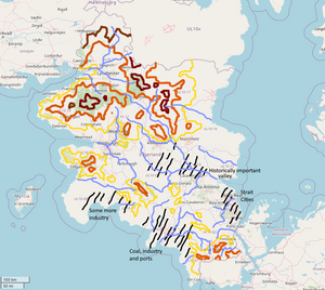
| I'm unsure to what degree I'll be participating in the collaborative areas, but I figure I'd make a plan just for discussion's sake. This shares a lot in common with Yuanls' sketch, but the areas of population are a little different. There's three big clusters of cities: an area around the capital, the strait cities (i feel like this would have been an important trade area historically disputed by Kalm), and a southern industrial belt to power the empire. I'm imagining Winburgh and Worthfield would be moved south. There's a southern chain of sporadic hills and a big clunky mountain range in the north. |
Discussion
There should be at least a low mountain range running from north to south of the country, maybe on the more western side. It kinda shows a ridge pattern that follows the islands and western side of Nordurland, and this mountain range might have affected the climate of the country like a rainshadow effect in real-world England. Senju (talk) 09:45, 29 April 2023 (UTC)
- I'm not quite sure what you're referring to? More generally, it might be worth making a sketch of highlands and lowlands. Yuanls (talk) 22:47, 29 April 2023 (UTC)
- I think the implication is either that the previous owner had a spine of glacial mountains, or something like the Pennines (which really aren't that rugged) would be desired here. I'm not taking a position on that either way, but it will need to be decided by the collective of mappers in Ingerland if there is anything notable and across regional borders. — Alessa (talk) 23:28, 29 April 2023 (UTC)
- You could always keep parts of the old north/south chain but they're more like sporadic hills, with gaps allowing for coast-to-coast corridors.--Fluffr Nuttr (talk) 00:06, 30 April 2023 (
- I think the implication is either that the previous owner had a spine of glacial mountains, or something like the Pennines (which really aren't that rugged) would be desired here. I'm not taking a position on that either way, but it will need to be decided by the collective of mappers in Ingerland if there is anything notable and across regional borders. — Alessa (talk) 23:28, 29 April 2023 (UTC)
Just a note: from what was there before Andy left, the common border between all parts of his territories and Norðurland was completely mountainous. I have not mapped many details, but everything I did map so far took this into account. --EMKLI (talk) 20:11, 29 April 2023 (UTC)
In general the geology of Britain doesn't seem too important: outside coastal areas, geology is mostly expressed though low hills in much of England (outside the north, where there's more geological variation). The expression Ingerish geology has on the landscape could therefore be left to the discretion of individual users. In terms of what's important, I propose we should pin down positions of coal fields (analogous to South Wales, the Black Country, the Pennines), and other industrial resources (e.g. metal mining in Cornwall). These resources heavily influence the industrial heritage of a region and thus human settlement, especially during and after the Industrial Revolution. On the upside, some large settlements are already mapped, and so we have a basis for where important resources may already be (assuming they won't be moved). Yuanls (talk) 22:47, 29 April 2023 (UTC)
- I agree with this fully. This was the important of why geology was even brought up. The resources will dictate things. That said, I would not rely too much on where settlements are presently mapped to pin things down. Everything left behind, including Winburgh, is up for relocation or removal just as much as staying. I would note that in the east-central regions, those relics from the past could as easily be wiped or relocated as anything else. They're a bit overbuilt and nonsensical in isolation, but we didn't want to wipe everything when there were some interesting things to potentially repurpose. — Alessa (talk) 23:28, 29 April 2023 (UTC)
Position: Ingerland is somewhat more northerly than the real UK (the southermost point of Ingerland is roughly the same latitude where Manchester, and the northernmost point is equivalent to the Faroes). This would impact the climate, and the overall shapes and features in the landscape, especially if we consider glaciations and postglacial landscapes (assuming the extent and timing of glaciations are roughly the same as they are in real life). This brings me on to one major issue I have about Ingerland: the coastline. The texture of coastline is very homogenous at the moment and does not reflect the diversity in geology and geomorphology that would be present in an area the size of Ingerland. Yuanls (talk) 22:47, 29 April 2023 (UTC)
- There is a bit of suspending disbelief that we will have to do regarding the climate, but that's only because this location is the best we can do. However, you are correct that the coastline will necessarily need work. That will be up to the regions at the guidance of the collaborative to make sense of it. The lowland marshes in the southeast should be kept to provide someone the ability to work with a terrain not unlike the Fens and other North Sea-inspired regions. — Alessa (talk) 23:28, 29 April 2023 (UTC)
History & human geography
Before we discuss modern issues, we need a solid historical and cultural coherency for the nation. Some things are clear, while some need to be discussed.
Certain things that are already established:
|
What to discuss:
It is worth noting that since history is not always perfectly defined in our world, these should be subtle references, events and consensuses that are still notable enough for the development of the nation. |
User proposals
Discussion
All my territories have some sort of history with Ingerland, but all that's particularly important toponymically is the existence of a King Earnest at some point in the 1560s or 1570s. Otherwise, I've assumed that Ingerland would have established a sizable trade/colonial empire (perhaps including trade companies), beginning to branch into the Asperic and Lyc by the early 1500s. I don't have anything else to add at the moment, but maybe I'll come up with a history proposal at some point... --Lithium-Ion (talk) 19:53, 29 April 2023 (UTC)
Just wanted to update: I am making a history proposal, hopefully I'll be ready to post it on here with nice graphics and everything in a few days, but if anyone wants to see it as I go it's on my sandbox. --Lithium-Ion (talk) 23:07, 1 May 2023 (UTC)
Your proposal looks good so far. I'm not too knowledgeable pre-modern stuff, but I look forwards to contributing some input on 19th/20th/21st century affairs. Yuanls (talk) 10:39, 6 May 2023 (UTC)
I'm not quite sure what comes into the category of 'modern issues' (modern as in contemporary 2023, or modern as in the 'modern era' of history). I should add that if users are basing their mapping on the state of the UK as it exists, with only a limited understanding of the trends behind urban development, we are implying that the modern history of Ingerland is roughly analogous to the UK in real life, down to very specific events which we'd either have to replicate, or find alternative explanations for. For example, WWII and the Blitz had signficant ramifications for British society, urban planning and the economy for decades to come. Other events are implicitly established in the 'OGF canon', i.e. the industrial revolution, the development of canals, railways, the proliferation of international trade - and can be pinned down by geology (discussed in the previous section) and geography (which already exists). I'm quite aware my approach might be a bit too detailed for this early stage, so please put this thread on hold if this is so. Yuanls (talk) 23:23, 29 April 2023 (UTC)
- You bring up absolutely valid points, and ones that will need to be worked out. Fortunately, there are generally some pretty good ways of retconning things to make them fit. I would state that as far as more modern lore is concerned, I see no reason that something akin to the Blitz happened during the Great War (1940s to early 1950s). Since there has been movement toward viewing that as a series of concurrent, loosely intertwined flashpoints, there is no reason Ingerland could not have encountered such an experience. The details of the war don't need to be ironed out yet, and I wouldn't necessarily assume Kalm as the enemy or any potential ideological alignment. Simply encountering the war in the way allows for a reasonable explanation until further details can be pinned down. — Alessa (talk) 13:50, 30 April 2023 (UTC)
That sounds sensible - I think we can keep it this vague for now. Yuanls (talk) 12:00, 3 May 2023 (UTC)
- Just raising a question - will current Ingerland be a monarchy or a republic?--Zhenkang (talk) 01:58, 5 May 2023 (UTC)
- I'd very much like to see republicanism play a larger role in Ingerish history, whether that be a historical period, or the modern state of the country. I feel it would be an interesting yet obvious deviation from the modern state of the UK. Yet again, this is probably a discussion for later on. Yuanls (talk) 11:07, 5 May 2023 (UTC)
Ingerland should be significantly influenced by either or both Kalm or Nordurland as it borders them directly or at least by the small bodies of water that separates it from Kalm to the south. Territories across the sea in the east (UL 10-98 and UL 10-99) could have been a kingdom/kingdoms that pledge alliance to Ingerland and would eventually be part of the nation. Sheeps, Fur, blubber, and marine resources could be traded in the region in early times, and played part in traditional clothing and food culture. The eastern part of the country could have developed earlier when trading was still concentrated with the countries in West Uletha, and later with the age of discovery and colonization made the western parts of the country more populous and industrial than the ones in the east. Senju (talk) 06:00, 30 April 2023 (UTC)
- I'm going to strongly disagree with your first point as an admin helping to oversee the launching of this project. Ingerland is, by necessity, a powerful cultural influencer in its own right. If anything, it would have exuded influence more than being influenced in its core territories. Now, does that mean there are no Kalmish influences in the south? Of course not. Borderlands are typically messy for a ton of reasons. That will be up to whomever takes those border regions to implement. Alternatively, and not necessarily the best option, would be to assume that Ingerland *lost* that strip of land from the narrow strait to its present Kalmish border at some point, which would require Kalm to adapt far more. These are the types of discussions that are pertinent to whomever decides to map those regions. — Alessa (talk) 13:50, 30 April 2023 (UTC)
An issue that has been raised a few times and will need to be ironed out before establishing Ingerland's historical and cultural basis is the geographic separation between Ingerland and Franqueterre. English culture has so many fundamental links to French culture (particularly in its language), it doesn't make much sense to suggest OGF's version of England and France had much less interaction than IRL's version. However, I think this suspension of disbelief (just say Ingerland and Franqueterre didn't interact much) is the best way to approach it, as no other explanation really makes sense. There exists plenty of IRL examples of languages and cultures being similar despite geographic separation (eg. Romanian).
On the origin of the nation, this can't be fully determined until the situation of OGF's Roman empire has been confirmed. As far as I'm aware, whether a "Roman Empire" even existed is undecided, let alone whether Ingerland would've been part of it. For now, I think any mention of an ancient empire should be avoided.
Noting this, here is my proposal for the origin of the nation: The island was settled by many pre-Celtic tribes. These tribes could be considered somewhat more advanced than IRL pre-Roman Britain, capable of building large bridges and roads that are the foundations of some settlements. Mass migrations of early Germanic peoples during the 1st millennium set up more formalized societal structures, eventually evolving into kingdoms. During this period, "Viking" raids would also greatly impact Ingerland. At some specific point in time at around 1100, an event in the Kalmish region caused a mass exodus of Franquese people from the Kalmish region to Ingerland. These Franquese people went on to lead the upper echelons of society. Perhaps early colonization by Ingerland was motivated by the Franquese desire to find a route to Franqueterre that avoids Kalm (the colonization patterns of Ingerland will never make sense, but this at least attempts to explain the strange colonization South-eastwards). Gubble (talk) 16:39, 5 May 2023 (UTC)
Infrastructure
With the geography in place, and the history/movement of people determined, the next step is to connect the all the settlements. This includes national railways, highways (and trunks), national roads (mainly primary), important ports, airports. Lower levels of infrastructure such as public transportation should be decided in each region by its own owner, with the exception of the collaborative regions, where the community should be working together.
Please have in mind the transportation network of Nordurland and Kalm, the two mapped neighboring states!
User proposals
Discussion
Not really a proposal but something to keep in mind - we may also want to think about things that the UK lacks which other countries may have, e.g. a developed high speed rail network. I think this would be very interesting to explore. Yuanls (talk) 22:47, 29 April 2023 (UTC)
- I think it could be an interesting play in Ingerland if we say, the equivalent of the Beeching Cuts were not undertaken, so the current Ingerland is super saturated with railways, then that would provide a bit better reason that there's less space for high-speed rail in a country that has a land-mass much larger than the UK does, if there's just no space to weave around a high-speed rail line. And it would also then inform why the Federal States has a marginally higher amount of commuter-rail than the RL analogue of the US, if the Federal States, or at least where the Ingerland colonies were, took a cue from the saturated rail services of Ingerland and carried it through to it's modern day. - Aces California (talk) 11:49, 1 May 2023 (UTC)
- This would be interesting, and would certainly have my endorsement. I am a sucker for mapping disused railways though, and for better or for worse, I do imagine there'd be some amount of closures, even if it were more protracted/less drastic than what happened IRL. Would love to look into this in the future! Yuanls (talk) 12:00, 3 May 2023 (UTC)
- The FSA would've declared independence from Ingerland decades before the first railways were constructed in either country. --TheMayor (talk) 15:25, 3 May 2023 (UTC)
Capital city
The capital city of Ingerland is located in the eastern part of the country, in the region #14∈⊾, being the administrative, cultural and economic center of the nation. It's designated as a collaborative territory meaning everyone interested is welcome to contribute. However, to prevent the city from being mapped chaotically and to allow it to grow naturally, the city should be planned thoroughly in this section before anything is mapped.
| NOTE: The capital should not be based directly off London. The city should have some distinct and unique characteristics. Nevertheless, London is welcome as an inspiration. |
What to discuss:
And various other aspects, bits and pieces... |
User proposals
Sudo91's proposal:
| At first, I would like to point out the suggested size for the capital. It will, of course, depend on how many people will live in Ingerland proper. If we take the population density of IRL UK (270/sq.km), Ingerland would have 139 mln. people. Although, I doubt that such population density is possible at such high latitudes, nor it can be as low as Scottish (67/sq.km). For my calculations down below, I took the population density of 150/sq.km. and got the supposed population of Ingerland at 77 310 000. (UK has 67 mln)
Whatever the case, we probably should keep the population density of Winburgh (I would also like to keep the same name; there are myriads of objects all around OGF named after Winburgh) around the same as London (5500-6000 per sq.km.) and the city area may accomodate 1500-2000 sq.km in total.
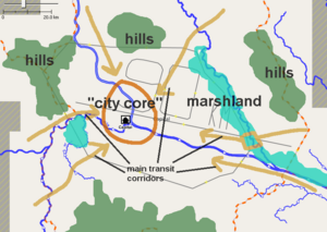
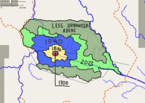
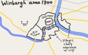
Location within capital regionThe capital should, of course, be placed along the river. I shifted the "centre" location to the position on the left because I believe it looks more defendable: rivers cut the access to the fort at three sides, and on the fourth side there are hills. Later on, the development of industry may lead to mass building at more flat areas, such as where "capital" marker is located on OGF at the moment. Geography of the regionHere is an another map featuring main obstacles that would play key role in city's strategic position -- hills and marshes. Most of the marshes would be gone by the present day, and hills were turned into national parks or natural reserves. Historical growthHere's the sketch map on how the growth will go. The city's size before 1700 was quite negligible.
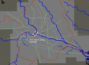
Population/sizeI would estimate the capital agglomeration's population at 8 mln - 11 mln. The capital region area's population should not exceed 15 mln people. I also have this very crude map of main railways (excluding local ones) and main motorways in agglomeration. My proposal is probably too early since we don't have main transport corridors planned. |
Discussion
The northeastern and the southern part of the capital region could be hilly as there are rivers from adjacent regions kinda originating in those locations. As a center of culture, economy, and administration, population could be at least 10% of the total population of Ingerland. In infrastructure, there could be a symmetrical layout of a palace surrounded by gardens as the seat of government, or castles that are now museums. Senju (talk) 02:11, 1 May 2023 (UTC)
I really don't want the capital to be called Winburgh - it is such an ugly name that's also not very typical of English naming conventions (it's much more like Edinburgh which is Scottish). Winburgh can stay as a decent sized city in the north. Gubble (talk) 16:39, 5 May 2023 (UTC)
Other topics
Something else on your mind? Write it here!
I've given a read through this and I'd be interested in shaping one of the regions, particularly the marshy, flat eastern region since I'm from Norfolk myself. Is there a link to territory applications that I'm missing? --Myrcia (talk) 18:58, 3 May 2023 (UTC)
- The territory applications can be accessed via the territories map and clicking on your desired region. Bixelkoven (talk) 19:29, 3 May 2023 (UTC)
Please could a section be added to this forum post be added to clarify the organizational structure of Ingerland (and provide a link to the collab page)? I know the structure is explained in detail on the collab page, but it would be useful to have a very brief summary here. Gubble (talk) 16:39, 5 May 2023 (UTC)
- I'd say it is described nicely on the page you mentioned, but I will go ahead and post a summary nevertheless.
- The entire country is divided up into regions that make up the whole of a unitary state. Two of the regions are "purple," meaning they are owned by the community and fully collaborative: the capital region and a second region that is a bit more rural in nature.
- Individual regions are not independent entities, nor are they like states of the United States. They possess little governmental authority. They are owned either by individual users, or as private collaborative projects.
- Users have a degree of mapping autonomy within their own territory, however several national questions and issues are to be determined on a national level (such as economy, nation-wide infrastructure, geography, culture, etc.). Ignoring national plans while mapping in a territory is unacceptable.
- Every territory owner and mapper within Ingerland forms together a council-equivalent, with a chosen leader (coordinator). The council should discuss the aforementioned issues and questions, and the coordinator should guide the entire team and the discussions.
- The collab regions (so far, only the capital region has been designated) can be mapped by anyone, following the plans which will be approved from this forum page.
- Bixelkoven (talk) 01:00, 6 May 2023 (UTC)
I wish to give a few clarifications about some things as well, since they have come up in messages.
- We recognize the regions are quite large from a real-world perspective. Please keep in mind that these regions are not too different than the nine regions of England in the real world (East of England, West Midlands, East Midlands, Yorkshire and the Humber, South West, etc.). They're simply regional administrative authorities, and they are pretty large.
- Similarly, we expect that all the regions of Ingerland could easily be divided into 3–6 historical counties. Whether or not these are mapped will be up to the members of the project.
- The size of the regions allows for people to have most types of mapping (urban, industrial, rural-agricultural, rural-industrial, etc.) in their territories without having to compete too much for who has the largest centers of population or the most coal mines.
- I wish to reiterate that the second collaborative territory will be picked after the first round of applications are approved. We want to give people a chance to get their first choice in before we isolate a specific one for collaboration.
- There has also been a question about ancient Celtic influences. Since Ingerland will need to have a cultural strata similar to real-world England, we would have expected Celtic influences in the Bronze and Iron Ages. The difference is that we don't want active Celtic influences to dominate the landscape akin to Wales or Scotland. These would be found in places like Regions 98 and 99 or in separate projects in territories nearby those regions if people were interested. UL10x is not planned to be a Scottish-inspired territory.
I'll add more here as necessary, but I hope this answers some questions that were frequently asked. — Alessa (talk) 21:53, 6 May 2023 (UTC)
Not sure where to put that, but: while I don’t intend to claim a territory in Ingerland, having already quite enough to do with my tiny little speck of dust of a country, I’ve noticed that UL-10-98 and -99 are marked as part of Ingerland but not yet available? So, what about them, should they be considered as a part of Ingerland as of now, and what’s there? (I ask because these territories are fairly close to my own (Searavenag, the smallest thing at the far end of the firth of Hetzer) so I’m curious if there’s any sort of consensus on the area. Unrelatedly, I remember being told that there used to be (still is?) an international organisation for the Vinn sea area, but it doesn’t seem to have much existence in practice, and the rebirth of Ingerland might be the right time to discuss international organisations in the area? — Portier (talk) 20:37, 8 May 2023 (UTC)
