Forum:Official collaboratives/Castellán: Difference between revisions
(proposal) |
|||
| Line 11: | Line 11: | ||
After a signifficant amount (actually 50%!) of the natural mapping of Castellán has progressed, we can start launching a pilot project on regional mapping (roads, settlements, agriculture, etc.) for man made features [https://opengeofiction.net/relation/292063 This is the province] I've decided we can start our efforts in. You can send your proposals for how roads and settlements can be placed. The provincial capital needs to be marked, as it will be the first city in Collab Castellán that will be mapped --[[User:Martinawa|Martinawa]] ([[User talk:Martinawa|talk]]) 11:36, 1 September 2022 (UTC) | After a signifficant amount (actually 50%!) of the natural mapping of Castellán has progressed, we can start launching a pilot project on regional mapping (roads, settlements, agriculture, etc.) for man made features [https://opengeofiction.net/relation/292063 This is the province] I've decided we can start our efforts in. You can send your proposals for how roads and settlements can be placed. The provincial capital needs to be marked, as it will be the first city in Collab Castellán that will be mapped --[[User:Martinawa|Martinawa]] ([[User talk:Martinawa|talk]]) 11:36, 1 September 2022 (UTC) | ||
=== '''Proposal voting''' === | |||
After one week and four proposals, I declare the proposal phase of the regional mapping close. After this, I will open a public voting for the proposals that have been drafted, starting from now until the end of Sunday, September 11 2022 (UTC). In order to vote, you just sign below the proposal you think is the best fit. I will also open a discussion section where people can point some aspects of the proposals that could be changed, and these will be taken into consideration for the final draft of the regional mapping of the area. | |||
Once the voting is finished, planning on the capital city of the province will begin. --[[User:Martinawa|Martinawa]] ([[User talk:Martinawa|talk]]) 19:16, 9 September 2022 (UTC) | |||
'''Proposal 1 (Izaland Terramorphing Commitee)''' | |||
'''Proposal 2 (Kalh79)''' | |||
'''Proposal 3 (Bixelkoven)''' | |||
'''Proposal 4 (Martinawa)''' | |||
=== Discuss about the proposals (and the eventual final draft) here === | |||
----Hello! ITC from Izaland and the neighboring Plevia here. | ----Hello! ITC from Izaland and the neighboring Plevia here. | ||
I’d like to give some of my contributes to Castellan for the Collab of the Month project. | I’d like to give some of my contributes to Castellan for the Collab of the Month project. | ||
Revision as of 19:16, 9 September 2022
This the Forum official discussion page for the Castellán collaborative project. Any questions, suggestions, feedback, and discussions will be held here. For more info on the state of the collab, please go to the collab page --Martinawa (talk) 00:31, 9 November 2021 (UTC)
¡Sentíos libres de escribir en Español, si así os sentís más cómodos!
Regional Mapping
This is part of the project for the Collab of the Month, September 2022
After a signifficant amount (actually 50%!) of the natural mapping of Castellán has progressed, we can start launching a pilot project on regional mapping (roads, settlements, agriculture, etc.) for man made features This is the province I've decided we can start our efforts in. You can send your proposals for how roads and settlements can be placed. The provincial capital needs to be marked, as it will be the first city in Collab Castellán that will be mapped --Martinawa (talk) 11:36, 1 September 2022 (UTC)
Proposal voting
After one week and four proposals, I declare the proposal phase of the regional mapping close. After this, I will open a public voting for the proposals that have been drafted, starting from now until the end of Sunday, September 11 2022 (UTC). In order to vote, you just sign below the proposal you think is the best fit. I will also open a discussion section where people can point some aspects of the proposals that could be changed, and these will be taken into consideration for the final draft of the regional mapping of the area.
Once the voting is finished, planning on the capital city of the province will begin. --Martinawa (talk) 19:16, 9 September 2022 (UTC)
Proposal 1 (Izaland Terramorphing Commitee)
Proposal 2 (Kalh79)
Proposal 3 (Bixelkoven)
Proposal 4 (Martinawa)
Discuss about the proposals (and the eventual final draft) here
Hello! ITC from Izaland and the neighboring Plevia here.
I’d like to give some of my contributes to Castellan for the Collab of the Month project.
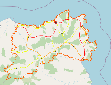
I can mostly help with railway infrastructure. It depends on where cities are going to be places, but I envision/propose something like this https://i.ibb.co/LN9kJdW/castellan-idea.png
Probably also a high speed railway will have to be built in the area. Since this region protrudes into the Mediterranean Sea, it is likely to have been controlling the sea access for centuries, so I think there would be largely developed cities as well. But I don't know where the capital will be located. --Izaland Terramorphing Committee (talk) 03:03, 2 September 2022 (UTC)
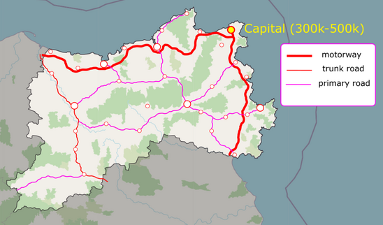
Hi, I also want to contribute with some idea in this project. Based on the map proposed by ITC, I propose a possible main road network for the Province chosen for the project, also the possible province capital: https://ibb.co/RBQYK44
What do you think?? Cheers --Kalh79 (talk) 16:56, 3 September 2022 (UTC)
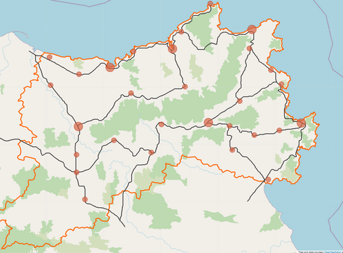
I was inspired to contribute to the planning of this province as well, henceforth I present you my plan from the province. It's worth noting that I had some inspiration from the ideas of Kahl and Izaland Terramorphing Committee as well.
My general idea is that the province would include one major and dominant city, a few medium-sized towns and scattered smaller towns. Most of the population would reside in the northeast of the province, gathered around the capital, ultimately forming a larger metropolitan area home to just about half of the province's population. The capital would be a historic shipping and trade center in the region, in the newer eras perhaps even a shipbuilding one. The town just north of it would act as a modern ferry connection to the other side of the Mediterranean sea (Coast of Shelakhs, Mardoumakhstan UL07d and Alora) as it is the closest point in Castellan to the mentioned territories.
Almost all of the infrastructure connections would be from and to the provincial capital and the port in the area, towards the national capital (which was assumed to be in the central part of the country), the potential major cities on the north coast and the future potential major cities in the south and southeast, with the highways and major railways following the coastline towards those areas. The railway connection from the inland areas would vital for the shipment of goods across the Mediterranean, making the capital one of the most important cities in the entirety of Castellán.
The inspiration primarily was the province of Asturias, given that it has a similar size to Cerro. Bixelkoven (talk) 21:41, 4 September 2022 (UTC)

My proposal for the province is to build the capital along the river mouth (Spanish: Ría), on the north of the province. Most of the secondary cities on the province would lie on the coast, with a few minor towns or a couple of cities on the valleys of the interior. Despite not being drawn, railways would mainly run parallel to the main roads drawn.
The capital on the ría would be around 300k proper, with a metro area that would be upwards of 500-600k, containing most of the industrial activity. Many towns of the coast would be prior fishing towns turned turistic, either from beaches or from their ports. Interior cities could be a mix of rural and industrial, holding a mix of mining/manufacturing plants and meat processing facilities. --Martinawa (talk) 00:01, 7 September 2022 (UTC)
Castellanese Symbols
This is part of the project for the Collab of the Month, September 2022
Flag of Castellán
Here you can post any ideas you have for a flag for Castellán. You can be as creative as you want, but should also explain the symbolism you decided for the flag. --Martinawa (talk) 14:48, 2 September 2022 (UTC)
Coat of Arms of Castellán
Here you can post any ideas you have for a coat of arms for Castellán. You can be as creative as you want, but should also explain the symbolism you decided for the flag. --Martinawa (talk) 14:48, 2 September 2022 (UTC)
Toponomy Ideas
This is part of the project for the Collab of the Month, September 2022
Here you can send any ideas you might have for toponyms in Castellán. Anything is allowed: Names for mountains, rivers, regions, capes, city names you might find interesting all around the mapped features on the map. Please send a link of the area where you might want the name to be in. --Martinawa (talk) 14:48, 2 September 2022 (UTC)
Natural Mapping
The natural mapping phase of Castellán is ongoing. Anyone who is interested in doing natural mapping of a region with a mediterranean climate, follow the instructions that will be given below.
For better organisation, anyone who wants to map natural features should contact Martinawa for authorisation. In the message, you may show prior work you have done on natural landcover as an indication of your skills.
After you've been given authorisation, you will be given a georreferenced file with the orography sketched (shown below) to use as a base for the natural cover. Before starting landcover you should make a boundary area, with admin_level=4, in the area you want to work on. This might be used in the future for the administrative divisions of the country, so please be creative about it. The area marked should be between 25000 and 50000 square kilometers, roughly. The idea for the landcover is to indicate only non-agricultural landuses: that is: forests, scrubs, bare rock, cliffs, marshes, wetlands, and such. Do not use grass or farmlands, especially in the flatter areas, as these will be dealt with later in the development of the country, after the settlements have been decided. --Martinawa (talk) 22:50, 13 February 2022 (UTC)
Users currently authorised to edit in the country:
- Martinawa ("Región del Sero", Northeast)
- Kalh79 ("Área de Preservación", Northwest)
- Lithium-Ion ("Región Occidental", west)
Users who have contributed to already finshed regions:
- Bixelkoven ("Región del Cabo", southeast)
- Martinawa ("Región Primera", "Región Segunda", "Región Noreste", and "Región del Este", north and northeast.)
- Rustem Pasha ("Región Turquesa", west)
Physical planning
Here we will discuss and suggest what the Castellán physical geography will look like.
As the Cleanup phase is finished for now, I'm going to close off proposals for physical plannings soon as we try to work out the final result. This is a shout-out to give people who have had ideas for coastline and physical geography an opportunity to post their suggestions now, as there's going to be an election of the final physical geography of Castellán soon --Martinawa (talk) 05:06, 19 December 2021 (UTC)
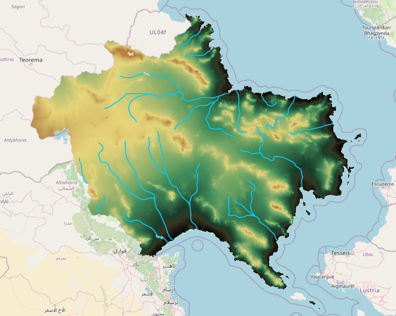
Orography sketch
After seeing all sent proposals and having reflected onto them and adapting to the new coast, I have made some temptative orography for Castellán as a base. The amount of detail shown is because this is procedurally generated (except for the rivers), but all mapping here shouldn't be followed very closely and treated more like a broad idea of what the country is going to be like, as things like scale and detail might just not be right for the size of the country given the features. The general idea, with a western plateau and parallel mountain ranges going roughly east to west, with graben-like plains in between. Placing is mostly inspired on the shape of the coastline. --Martinawa (talk) 01:10, 19 January 2022 (UTC)
- How high do you think the tallest mountains would be? Maybe that northern range could have a few noticeable "offshoots" or parallel ridges like the Alps, since it's the southernmost part of a large mountain range similar to them. Otherwise looks really nice, no complaints at all.--Lithium-Ion (talk) 01:20, 19 January 2022 (UTC)
Cleanup
The cleanup phase is now finished. Please head to later sections to know about the state of the collaboration and to know what to do on it. The areas you might see on the map that are not blanked are intentionally so and will be treated specially by the coordinators for now.
The first stage mapping-wise will be the complete clean-up of the mapping of Castellán. All mapping previous to the setting of the collaborative stage is expected to be removed. The only mapping that will be pre-emptively conserved will be whatever is on the border with Mazan, specially land cover that spans both countries. Coastline is not to be changed either yet. --Martinawa (talk) 23:10, 18 December 2021 (UTC)


