Weekly site maintenance is scheduled Thursday 04:00–06:00 UTC.
Editing will not be possible during this time, and there may be other brief disruptions. (additional info)
Forum:Official collaboratives/Castellán: Difference between revisions
Bixelkoven (talk | contribs) No edit summary |
|||
| (86 intermediate revisions by 13 users not shown) | |||
| Line 7: | Line 7: | ||
''¡Sentíos libres de escribir en Español, si así os sentís más cómodos!'' | ''¡Sentíos libres de escribir en Español, si así os sentís más cómodos!'' | ||
== | ==Urban Mapping== | ||
<s>After the Regional mapping for the first province has been decided and mapped (congratulations to Bixelkoven!), we will move to the urban mapping of the area. This is the system we will use for the mapping of towns and cities in the area:</s> | |||
' | Before starting on the urban breakdown, I'd reccomend to use [https://drive.google.com/file/d/1-TPdn4xyhV6FmhOlehfZPhE1Cc1NlTzq/view?usp=sharing this resource] to try and make an idea of what do you want your Castellan city, town or village to look like. | ||
'''IMPORTANT:''' For organisation purposes, please specify which town of city you want to map so I can reserve it for you, so we don't end up having several people mapping on a single town by mistake. Also, do not map before I give you permission to do so. Look at the list of towns and cities assigned below for more details. --[[User:Martinawa|Martinawa]] ([[User talk:Martinawa|talk]]) 13:11, 16 September 2022 (UTC) | |||
Provinces currently enabled for urban mapping in Castellán are: | |||
{{Relation|292063|Ricuesa}} | |||
{{Relation|292064|Hostellón}} | |||
{{Relation|292066|Valdobreón}} | |||
If you want to map settlements in any of these areas, please [https://opengeofiction.net/message/new/Martinawa contact Martinawa] with your plans. Send previous mapping of yours so we can find the best fit possible for what you can do. Any sketches and plans are welcome, but not necessarily required, although a larger settlement or area to map will carry with it a bigger burden of clearance. --[[User:Martinawa|Martinawa]] ([[User talk:Martinawa|talk]]) 22:56, 19 January 2024 (UTC) | |||
====Assigned towns and cities==== | |||
*[https://opengeofiction.net/node/283221233#map=14/37.4052/65.0252&layers=B Maldonado] to [[User:BMSOUZA|BMSOUZA]] | |||
*[https://opengeofiction.net/node/283221256#map=16/37.4915/63.7807&layers=B Rivamuca] to [[User:Martinawa|Martinawa]] | |||
*[https://www.opengeofiction.net/node/283220649#map=16/37.6947/64.8572&layers=B Villafranca del Carante] to [[User:Brunanter|Brunanter]] | |||
*[https://opengeofiction.net/node/283221222#map=16/37.9570/64.3963&layers=B Villanueva de Orñán] to [[User:Kalh79|Kalh79]] | |||
*[https://opengeofiction.net/node/283221273#map=16/37.8406/64.0099&layers=B San Martín de la Peña] to [[User:Bixelkoven|Bixelkoven]] | |||
*[https://opengeofiction.net/node/283221276 "Ciudad Mediana"] to [[User:Davieerr|Davieerr]] | |||
*[https://opengeofiction.net/node/283221272 Valdepinares] to [[User:Jjrc1996|jjrc1996]] | |||
*[https://opengeofiction.net/node/283221238 Puebla de Argas] to [[User:Jjrc1196|jjrc1196]] | |||
*[https://opengeofiction.net/node/298374311 Hostellón] to [[User:Martinawa|Martinawa]] and [[User:Bixelkoven|Bixelkoven]] | |||
== | == Capital City== | ||
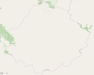
[[File:Castellan capital blank.png|thumb|Blank map of the capital province, to use for planning sketches.]] | |||
{{Relation|406019|A relation area}} has been reserved for the capital city of Castellán. This area will be where the capital of Castellán, its largest city and a major metropolitan area in West Uletha, will be placed. The area reserved is mostly for the immediate metro area, with potential for some overspill outside of it, but the target should be for something around a 5-10 million metro area. | |||
The two main issue to be discussed, '''the name of the city and the shape of it'''. You can send here proposals for either what you want the city to look like, or what name you would like for it. --[[User:Martinawa|Martinawa]] ([[User talk:Martinawa|talk]]) 22:56, 19 January 2024 (UTC) | |||
=== | ===Geoc3ladus Proposal(s)=== | ||
Below is a provisional sketch that I made for the capital city of Castellan as well as some other minor cities. Given the current geography and topography of the surrounding land, I feel as if this sketch as of now is accurate to the region. One obvious downside to this is its similarity in shape to Madrid, given how the outer suburbs and surrounding cities are placed in a similar manner, in similar locations. This could be overlooked if comparisons do not draw any significant suspicions. | |||
[[File:Castellan Capital Planning.png|thumb|left|Geoc3ladus' sketch for the capital city.]] | |||
Key: | |||
=== | *Purple = Ciudad real (Pequeña ciudad for other surrounding cities) | ||
*Red = Pueblo importante | |||
*Orange = Pueblo mediano/menor | |||
*Yellow = Suburbio importante/menor | |||
--[[User:Geoc3ladus|Geoc3ladus]] ([[User talk:Geoc3ladus|talk]]) 18:20, 20 January 2024 (UTC) | |||
The | ===Mie's Proposals=== | ||
[[File:Mie_Castellan_capital.png|thumb|left|Mie's sketch for the capital city.]] | |||
This is my suggestion for the future capital of Castellan. The city is based of several places around Spain and Latin Europe. The population of the city would probably oscillate closer to the 10 million mark. The general plan includes a medieval (or even ancient) old town, surrounded by a layer of parks and a small ring, followed by planned suburbs inspired by Valencia. On the southern side of the river there would be a sizeable park and a more organic, unplanned layout. In the southwest a huge planned development would be made, influenced by suburbs of Madrid. The city has an extensive motorway network spanning the area, as well as fitting railway and metro systems. | |||
I also came up with some possible name ideas: | |||
* '''Tamid''' | from Persian "pure" | |||
* '''Jaruca''' | from Hebrew "gold town" | |||
* '''Anaja''' ''or'' '''Maltaquin''' | from Arabic "river meeting" | |||
--[[User:Mie|Mie]] ([[User talk:Mie|talk]]) 17:28, 2 February 2024 (UTC) | |||
I | === Bixelkoven's Proposal === | ||
[[File:Castellan capital proposal Bixelkoven.png|thumb|right|Bixelkoven's idea for the capital city.]] | |||
I present my proposal for the capital city. Some details including the historical growth and idea behind the city's layout is noted on the image (right). It's worth mentioning that I did not designate landuses in the city, that is open for interpretation by the community should this proposal be accepted. The main inspiration was Madrid however I tried to make the city's layout as original as possible. There are some similarities with the city of Lyon in France. I disliked the idea of the capital laying on a completely flat plain so I moved the city a bit closer to the mountain range and added hills to the south of the city which would attract the first settlers to built the first traces of the settlement. The city is located on a very favorable passage spot between the north and south parts of Castellán, so it would be wise to emphasize the geographic importance for the city. The geography south of the main river would be hilly with smooth rolling terrain, likewise for the entire stretch between the old town and the mountains in the west, while the north and east would open up more into plains. Urban growth would primarily follow the routes to other cities in 4 phases: | |||
*Foundation of the first houses and observation tower on the foothills on the river delta | |||
*Establishing itself as a transit town with slightly increased growth towards the north towards the Mediterranean ports | |||
*Colonial era and shift towards the south with increased development along the routes towards the southern port cities | |||
*Industrial era and shift towards the north and east with increased development along the routes towards the Mediterranean port cities | |||
The historical population growth is inspired by Paris' historical population primarily. Like most cities in Europe, its urban core is seeing a population decrease while the outskirts are rapidly growing, slowly joining the nearby towns into the capital city's main urban core. I didn't draw too much high level infrastructure, instead I gave focus to the major arterials including primaries and secondaries. I don't have any name proposals. ⸺ [[User:Bixelkoven|Bixelkoven]] ([[User talk:Bixelkoven|talk]]) (West Uletha Admin) 13:26, 2 March 2024 (UTC) | |||
==Natural Mapping== | |||
'''The natural mapping phase of Castellán is ongoing. Anyone who is interested in doing natural mapping of a region with a mediterranean climate, follow the instructions that will be given below.''' | |||
[ | For better organisation, anyone who wants to map natural features should [https://opengeofiction.net/message/new/Martinawa contact Martinawa] for authorisation. In the message, you may show prior work you have done on natural landcover as an indication of your skills. | ||
After you've been given authorisation, you will be given a georreferenced file with the orography sketched (shown below) to use as a base for the natural cover. '''Before starting landcover you should make a boundary area, with admin_level=4, in the area you want to work on.''' This might be used in the future for the administrative divisions of the country, so please be creative about it. The area marked should be between 25000 and 50000 square kilometers, roughly. The idea for the landcover is to indicate only non-agricultural landuses: that is: forests, scrubs, bare rock, cliffs, marshes, wetlands, and such. Do not use grass or farmlands, especially in the flatter areas, as these will be dealt with later in the development of the country, after the settlements have been decided. --[[User:Martinawa|Martinawa]] ([[User talk:Martinawa|talk]]) 22:50, 13 February 2022 (UTC) | |||
'''Users currently authorised to edit in the country:''' | |||
* | * Geoc3ladus ({{Relation|364598|Región de Lomasplatas}}, north) | ||
*Martinawa ({{Relation|403355|Región de Levante}}, east) | |||
* | |||
====Vacated regions looking for a user to finish them==== | |||
*{{Relation|287793|Región Occidental}}, west | |||
'''Users who have contributed to already finshed regions:''' | |||
*Bixelkoven ({{Relation|287116|Región del Cabo}}, southeast) | |||
*Martinawa ({{Relation|286175|Región Primera}}, {{Relation|287092|Región Segunda}}, {{Relation|292067|Región Noreste}}, {{Relation|301330|Región del Este}} and {{Relation|311106|Región del Sero}}, north and northeast.) | |||
*Rustem Pasha ({{Relation|310478|Región Turquesa}}, west) | |||
*Kalh79 ({{Relation|365418|Región Sarrense}} and {{Relation|377219|Región Valasca}}, northwest) | |||
==Castellanese Symbols == | |||
''This is part of the project for the Collab of the Month, September 2022'' | |||
===Flag of Castellán=== | |||
[[File:Castellan flag.png|center|thumb|600x600px|Chosen design for the flag of Castellán]] | |||
This will provisionally be assumed as the flag of Castellán, as this process has been stagnated enough as it's been. Any changes (Colour tones, details of the coat of arms) will be applied onto this file for ease of utility. --[[User:Martinawa|Martinawa]] ([[User talk:Martinawa|talk]]) 00:46, 2 January 2024 (UTC) | |||
===Coat of Arms of Castellán=== | |||
Here you can post any ideas you have for a coat of arms for Castellán. You can be as creative as you want, but should also explain the symbolism you decided for the flag. --[[User:Martinawa|Martinawa]] ([[User talk:Martinawa|talk]]) 14:48, 2 September 2022 (UTC) | |||
====BMSouza proposal==== | |||
[[File:Proposal_Castellan0_BMSouza.png|400px|thumb|rightt|BMSouza proposal]]H ere is my proposal. | |||
*There is a crown, representing the royalty (is Castellan a kingdom?); | |||
**I consider to include details in this crown - some jewelry would be nice, but currently I only am using a simple crown I tried to use in another medieval-style badges, hehehe; | |||
*A stripe with the name of the country (a national motto, if existing, would not fit well in this size, hehehe), written using an old-style font; | |||
*Inside the badge, there is a half with blue and gold stripes - changing one colour (red to blue) and rotating the stripes from the real Catalunya/ Valencia/ Baleares/ Aragon flags; | |||
*Also inside the badge, in the right half, there is a lion head, representing some royal family. This part uses again the national colours; | |||
*A laurel wreath - no specific explanation, just looks nice in a coat of arms, hehehe; | |||
*What do you say? -- [[User:BMSOUZA|BMSOUZA]] ([[User talk:BMSOUZA|talk]]) 04:49, 19 September 2022 (UTC) | |||
==== Huachachi Proposals==== | |||
[[File:Hua Cast Coat Proposal 1.png|400px|left|thumb|Huachachi Proposal 1]] [[File:Hua Cast Coat Proposal 2.png|400px|right|thumb|Huachachi Proposal 2]] [[File:Hua Cast Coat Proposal 3.png|400px|centre|thumb|Huachachi Proposal 3]] We can see a coat of arms in a very European style. The shape is circular with little cells in it for smaller emblems. We also see an [[wikipedia:Astrolabe|Astrolabe]] that only shows the outer ring on the first proposal and also includes the measurement tool on the second proposal. On the top, we can see a crown composed of a castle shape on the bottom and a real crown shape on top. For the emblems, we have first the Castle, that represents the country of Castellán itself. After this we see the lion, another important element on Hispanic emblems. The two next symbols we can talk about are the cross and the muslim moon. This shows the past religious history of the country and the struggle between the Christianity and Islam on the region and a reference to medieval times. Next in line we see the conquistador helmet and the compass. These two represent the colonial history of the country and their impact on the ogf world. On the sides, we see two eagles facing the exterior. These two have the meaning of representing the imperial past, but also they sort of defend the interior of the coat. To make it look more secure. And at last we have two cells with crossed red lines. I’ll just leave this like it is and we can find a meaning if we want. Could be something related to royal families or a territory. In the second proposal we also see the castle symbol in the bottom and in the centre the letters Alpha and Omega, to symbolise the start and end of all things and also some Christian importance in medieval times. | |||
[[User:Huachachi|Huachachi]] 23:45, 19 September 2022 (UTC) | |||
==Toponomy Ideas== | |||
''This is part of the project for the Collab of the Month, September 2022'' | |||
[[ | Here you can send any ideas you might have for toponyms in Castellán. Anything is allowed: Names for mountains, rivers, regions, capes, city names you might find interesting all around the mapped features on the map. Please send a link of the area where you might want the name to be in. --[[User:Martinawa|Martinawa]] ([[User talk:Martinawa|talk]]) 14:48, 2 September 2022 (UTC) | ||
====BMSouza Proposals==== | |||
Well, here I list some names that, looks spanish enough to me, hehehe. All of them, intended to name cities or towns. | |||
* Valverde | |||
*Olivarría | |||
* Vallerrubio | |||
*Palma del Mar | |||
*Miraflor | |||
*Villalba | |||
* Puerto Vallejo | |||
[[User:BMSOUZA|BMSOUZA]] ([[User talk:BMSOUZA|talk]]) 01:42, 21 September 2022 (UTC) | |||
* | ===Geoc3ladus Proposals=== | ||
Here is a list that I came up with, like BMSOUZA said, they look spanish enough to me. These are more meant to represent larger cities or towns. | |||
*Montanabres | |||
*Tolarracól | |||
*Cinzenares | |||
*Hacieón | |||
*Salcombres | |||
* Colobriél | |||
* Vivesaro | |||
*Lomevera | |||
[[User:Geoc3ladus|Geoc3ladus]] ([[User talk:Geoc3ladus|talk]]) 21:33, 19 January 2024 (UTC) | |||
==Physical planning== | |||
Here we will discuss and suggest what the Castellán physical geography will look like. | |||
'''As the Cleanup phase is finished for now, I'm going to close off proposals for physical plannings soon as we try to work out the final result. This is a shout-out to give people who have had ideas for coastline and physical geography an opportunity to post their suggestions now, as there's going to be an election of the final physical geography of Castellán soon''' --[[User:Martinawa|Martinawa]] ([[User talk:Martinawa|talk]]) 05:06, 19 December 2021 (UTC) | |||
===Orography sketch=== | |||
[[File:Castellan | After seeing all sent proposals and having reflected onto them and adapting to the new coast, I have made some temptative orography for Castellán as a base. The amount of detail shown is because this is procedurally generated (except for the rivers), but all mapping here shouldn't be followed very closely and treated more like a broad idea of what the country is going to be like, as things like scale and detail might just not be right for the size of the country given the features. The general idea, with a western plateau and parallel mountain ranges going roughly east to west, with graben-like plains in between. Placing is mostly inspired on the shape of the coastline. --[[User:Martinawa|Martinawa]] ([[User talk:Martinawa|talk]]) 01:10, 19 January 2022 (UTC) | ||
[[File:Castellan topo idea.png|800px|center|Base Orography proposal]] | |||
:How high do you think the tallest mountains would be? Maybe that northern range could have a few noticeable "offshoots" or parallel ridges like the Alps, since it's the southernmost part of a large mountain range similar to them. Otherwise looks really nice, no complaints at all.--[[User:Lithium|Lithium-Ion]] ([[User talk:Lithium|talk]]) 01:20, 19 January 2022 (UTC) | |||
[[ | Sorry if this is totally in the way of what you're doing (feel free to d, but are you still open to more collabbers (is that a word?) joining? If so, I would love to join. For what it's worth, hablo español, asi que el idioma no sería un problema para mí :) -- [[User:Anonymous21|Anonymous21]] ([[User talk:Anonymous21|talk]]) 00:42, 24 February 2023 (UTC) | ||
==Cleanup == | |||
'''The cleanup phase is now finished. Please head to later sections to know about the state of the collaboration and to know what to do on it. The areas you might see on the map that are not blanked are intentionally so and will be treated specially by the coordinators for now.''' | |||
--[[User:Martinawa|Martinawa]] ([[User talk:Martinawa|talk]]) | The first stage mapping-wise will be the complete clean-up of the mapping of Castellán. All mapping previous to the setting of the collaborative stage is expected to be removed. The only mapping that will be pre-emptively conserved will be whatever is on the border with Mazan, specially land cover that spans both countries. Coastline is not to be changed either yet. --[[User:Martinawa|Martinawa]] ([[User talk:Martinawa|talk]]) 23:10, 18 December 2021 (UTC) | ||
: | :Many thanks to TCC and Rustem for helping clean up the area. You three have done a great job, and the help is very appreciated! — [[User:Alessa|Alessa]] <sub>([[User talk:Alessa|talk]])</sub> 15:33, 23 December 2021 (UTC) | ||
Latest revision as of 13:26, 2 March 2024
This the Forum official discussion page for the Castellán collaborative project. Any questions, suggestions, feedback, and discussions will be held here. For more info on the state of the collab, please go to the collab page --Martinawa (talk) 00:31, 9 November 2021 (UTC)
¡Sentíos libres de escribir en Español, si así os sentís más cómodos!
Urban Mapping
After the Regional mapping for the first province has been decided and mapped (congratulations to Bixelkoven!), we will move to the urban mapping of the area. This is the system we will use for the mapping of towns and cities in the area:
Before starting on the urban breakdown, I'd reccomend to use this resource to try and make an idea of what do you want your Castellan city, town or village to look like.
IMPORTANT: For organisation purposes, please specify which town of city you want to map so I can reserve it for you, so we don't end up having several people mapping on a single town by mistake. Also, do not map before I give you permission to do so. Look at the list of towns and cities assigned below for more details. --Martinawa (talk) 13:11, 16 September 2022 (UTC)
Provinces currently enabled for urban mapping in Castellán are:
If you want to map settlements in any of these areas, please contact Martinawa with your plans. Send previous mapping of yours so we can find the best fit possible for what you can do. Any sketches and plans are welcome, but not necessarily required, although a larger settlement or area to map will carry with it a bigger burden of clearance. --Martinawa (talk) 22:56, 19 January 2024 (UTC)
Assigned towns and cities
- Maldonado to BMSOUZA
- Rivamuca to Martinawa
- Villafranca del Carante to Brunanter
- Villanueva de Orñán to Kalh79
- San Martín de la Peña to Bixelkoven
- "Ciudad Mediana" to Davieerr
- Valdepinares to jjrc1996
- Puebla de Argas to jjrc1196
- Hostellón to Martinawa and Bixelkoven
Capital City
A relation area∈⊾ has been reserved for the capital city of Castellán. This area will be where the capital of Castellán, its largest city and a major metropolitan area in West Uletha, will be placed. The area reserved is mostly for the immediate metro area, with potential for some overspill outside of it, but the target should be for something around a 5-10 million metro area.
The two main issue to be discussed, the name of the city and the shape of it. You can send here proposals for either what you want the city to look like, or what name you would like for it. --Martinawa (talk) 22:56, 19 January 2024 (UTC)
Geoc3ladus Proposal(s)
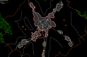
Below is a provisional sketch that I made for the capital city of Castellan as well as some other minor cities. Given the current geography and topography of the surrounding land, I feel as if this sketch as of now is accurate to the region. One obvious downside to this is its similarity in shape to Madrid, given how the outer suburbs and surrounding cities are placed in a similar manner, in similar locations. This could be overlooked if comparisons do not draw any significant suspicions.
Key:
- Purple = Ciudad real (Pequeña ciudad for other surrounding cities)
- Red = Pueblo importante
- Orange = Pueblo mediano/menor
- Yellow = Suburbio importante/menor
--Geoc3ladus (talk) 18:20, 20 January 2024 (UTC)
Mie's Proposals
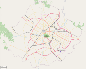
This is my suggestion for the future capital of Castellan. The city is based of several places around Spain and Latin Europe. The population of the city would probably oscillate closer to the 10 million mark. The general plan includes a medieval (or even ancient) old town, surrounded by a layer of parks and a small ring, followed by planned suburbs inspired by Valencia. On the southern side of the river there would be a sizeable park and a more organic, unplanned layout. In the southwest a huge planned development would be made, influenced by suburbs of Madrid. The city has an extensive motorway network spanning the area, as well as fitting railway and metro systems.
I also came up with some possible name ideas:
- Tamid | from Persian "pure"
- Jaruca | from Hebrew "gold town"
- Anaja or Maltaquin | from Arabic "river meeting"
--Mie (talk) 17:28, 2 February 2024 (UTC)
Bixelkoven's Proposal
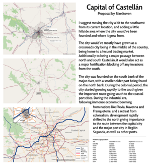
I present my proposal for the capital city. Some details including the historical growth and idea behind the city's layout is noted on the image (right). It's worth mentioning that I did not designate landuses in the city, that is open for interpretation by the community should this proposal be accepted. The main inspiration was Madrid however I tried to make the city's layout as original as possible. There are some similarities with the city of Lyon in France. I disliked the idea of the capital laying on a completely flat plain so I moved the city a bit closer to the mountain range and added hills to the south of the city which would attract the first settlers to built the first traces of the settlement. The city is located on a very favorable passage spot between the north and south parts of Castellán, so it would be wise to emphasize the geographic importance for the city. The geography south of the main river would be hilly with smooth rolling terrain, likewise for the entire stretch between the old town and the mountains in the west, while the north and east would open up more into plains. Urban growth would primarily follow the routes to other cities in 4 phases:
- Foundation of the first houses and observation tower on the foothills on the river delta
- Establishing itself as a transit town with slightly increased growth towards the north towards the Mediterranean ports
- Colonial era and shift towards the south with increased development along the routes towards the southern port cities
- Industrial era and shift towards the north and east with increased development along the routes towards the Mediterranean port cities
The historical population growth is inspired by Paris' historical population primarily. Like most cities in Europe, its urban core is seeing a population decrease while the outskirts are rapidly growing, slowly joining the nearby towns into the capital city's main urban core. I didn't draw too much high level infrastructure, instead I gave focus to the major arterials including primaries and secondaries. I don't have any name proposals. ⸺ Bixelkoven (talk) (West Uletha Admin) 13:26, 2 March 2024 (UTC)
Natural Mapping
The natural mapping phase of Castellán is ongoing. Anyone who is interested in doing natural mapping of a region with a mediterranean climate, follow the instructions that will be given below.
For better organisation, anyone who wants to map natural features should contact Martinawa for authorisation. In the message, you may show prior work you have done on natural landcover as an indication of your skills.
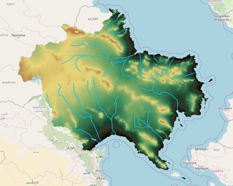
After you've been given authorisation, you will be given a georreferenced file with the orography sketched (shown below) to use as a base for the natural cover. Before starting landcover you should make a boundary area, with admin_level=4, in the area you want to work on. This might be used in the future for the administrative divisions of the country, so please be creative about it. The area marked should be between 25000 and 50000 square kilometers, roughly. The idea for the landcover is to indicate only non-agricultural landuses: that is: forests, scrubs, bare rock, cliffs, marshes, wetlands, and such. Do not use grass or farmlands, especially in the flatter areas, as these will be dealt with later in the development of the country, after the settlements have been decided. --Martinawa (talk) 22:50, 13 February 2022 (UTC)
Users currently authorised to edit in the country:
- Geoc3ladus (Región de Lomasplatas∈⊾, north)
- Martinawa (Región de Levante∈⊾, east)
Vacated regions looking for a user to finish them
- Región Occidental∈⊾, west
Users who have contributed to already finshed regions:
- Bixelkoven (Región del Cabo∈⊾, southeast)
- Martinawa (Región Primera∈⊾, Región Segunda∈⊾, Región Noreste∈⊾, Región del Este∈⊾ and Región del Sero∈⊾, north and northeast.)
- Rustem Pasha (Región Turquesa∈⊾, west)
- Kalh79 (Región Sarrense∈⊾ and Región Valasca∈⊾, northwest)
Castellanese Symbols
This is part of the project for the Collab of the Month, September 2022
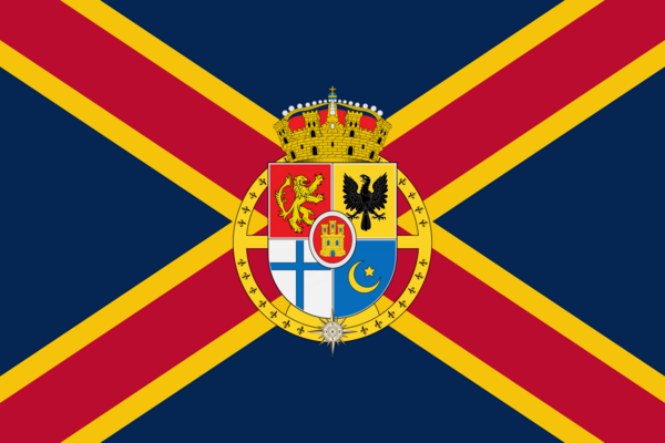
Flag of Castellán
This will provisionally be assumed as the flag of Castellán, as this process has been stagnated enough as it's been. Any changes (Colour tones, details of the coat of arms) will be applied onto this file for ease of utility. --Martinawa (talk) 00:46, 2 January 2024 (UTC)
Coat of Arms of Castellán
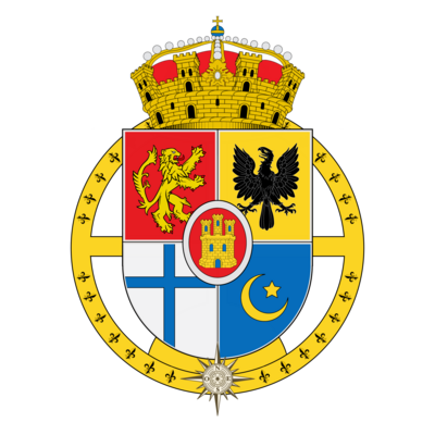
Here you can post any ideas you have for a coat of arms for Castellán. You can be as creative as you want, but should also explain the symbolism you decided for the flag. --Martinawa (talk) 14:48, 2 September 2022 (UTC)
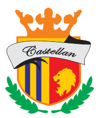
BMSouza proposal
H ere is my proposal.
- There is a crown, representing the royalty (is Castellan a kingdom?);
- I consider to include details in this crown - some jewelry would be nice, but currently I only am using a simple crown I tried to use in another medieval-style badges, hehehe;
- A stripe with the name of the country (a national motto, if existing, would not fit well in this size, hehehe), written using an old-style font;
- Inside the badge, there is a half with blue and gold stripes - changing one colour (red to blue) and rotating the stripes from the real Catalunya/ Valencia/ Baleares/ Aragon flags;
- Also inside the badge, in the right half, there is a lion head, representing some royal family. This part uses again the national colours;
- A laurel wreath - no specific explanation, just looks nice in a coat of arms, hehehe;
- What do you say? -- BMSOUZA (talk) 04:49, 19 September 2022 (UTC)
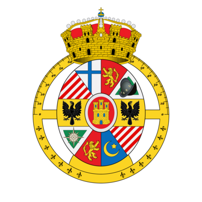
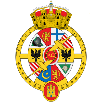
Huachachi Proposals
We can see a coat of arms in a very European style. The shape is circular with little cells in it for smaller emblems. We also see an Astrolabe that only shows the outer ring on the first proposal and also includes the measurement tool on the second proposal. On the top, we can see a crown composed of a castle shape on the bottom and a real crown shape on top. For the emblems, we have first the Castle, that represents the country of Castellán itself. After this we see the lion, another important element on Hispanic emblems. The two next symbols we can talk about are the cross and the muslim moon. This shows the past religious history of the country and the struggle between the Christianity and Islam on the region and a reference to medieval times. Next in line we see the conquistador helmet and the compass. These two represent the colonial history of the country and their impact on the ogf world. On the sides, we see two eagles facing the exterior. These two have the meaning of representing the imperial past, but also they sort of defend the interior of the coat. To make it look more secure. And at last we have two cells with crossed red lines. I’ll just leave this like it is and we can find a meaning if we want. Could be something related to royal families or a territory. In the second proposal we also see the castle symbol in the bottom and in the centre the letters Alpha and Omega, to symbolise the start and end of all things and also some Christian importance in medieval times.
Huachachi 23:45, 19 September 2022 (UTC)
Toponomy Ideas
This is part of the project for the Collab of the Month, September 2022
Here you can send any ideas you might have for toponyms in Castellán. Anything is allowed: Names for mountains, rivers, regions, capes, city names you might find interesting all around the mapped features on the map. Please send a link of the area where you might want the name to be in. --Martinawa (talk) 14:48, 2 September 2022 (UTC)
BMSouza Proposals
Well, here I list some names that, looks spanish enough to me, hehehe. All of them, intended to name cities or towns.
- Valverde
- Olivarría
- Vallerrubio
- Palma del Mar
- Miraflor
- Villalba
- Puerto Vallejo
BMSOUZA (talk) 01:42, 21 September 2022 (UTC)
Geoc3ladus Proposals
Here is a list that I came up with, like BMSOUZA said, they look spanish enough to me. These are more meant to represent larger cities or towns.
- Montanabres
- Tolarracól
- Cinzenares
- Hacieón
- Salcombres
- Colobriél
- Vivesaro
- Lomevera
Geoc3ladus (talk) 21:33, 19 January 2024 (UTC)
Physical planning
Here we will discuss and suggest what the Castellán physical geography will look like.
As the Cleanup phase is finished for now, I'm going to close off proposals for physical plannings soon as we try to work out the final result. This is a shout-out to give people who have had ideas for coastline and physical geography an opportunity to post their suggestions now, as there's going to be an election of the final physical geography of Castellán soon --Martinawa (talk) 05:06, 19 December 2021 (UTC)
Orography sketch
After seeing all sent proposals and having reflected onto them and adapting to the new coast, I have made some temptative orography for Castellán as a base. The amount of detail shown is because this is procedurally generated (except for the rivers), but all mapping here shouldn't be followed very closely and treated more like a broad idea of what the country is going to be like, as things like scale and detail might just not be right for the size of the country given the features. The general idea, with a western plateau and parallel mountain ranges going roughly east to west, with graben-like plains in between. Placing is mostly inspired on the shape of the coastline. --Martinawa (talk) 01:10, 19 January 2022 (UTC)
- How high do you think the tallest mountains would be? Maybe that northern range could have a few noticeable "offshoots" or parallel ridges like the Alps, since it's the southernmost part of a large mountain range similar to them. Otherwise looks really nice, no complaints at all.--Lithium-Ion (talk) 01:20, 19 January 2022 (UTC)
Sorry if this is totally in the way of what you're doing (feel free to d, but are you still open to more collabbers (is that a word?) joining? If so, I would love to join. For what it's worth, hablo español, asi que el idioma no sería un problema para mí :) -- Anonymous21 (talk) 00:42, 24 February 2023 (UTC)
Cleanup
The cleanup phase is now finished. Please head to later sections to know about the state of the collaboration and to know what to do on it. The areas you might see on the map that are not blanked are intentionally so and will be treated specially by the coordinators for now.
The first stage mapping-wise will be the complete clean-up of the mapping of Castellán. All mapping previous to the setting of the collaborative stage is expected to be removed. The only mapping that will be pre-emptively conserved will be whatever is on the border with Mazan, specially land cover that spans both countries. Coastline is not to be changed either yet. --Martinawa (talk) 23:10, 18 December 2021 (UTC)
