Forum:Official collaboratives/Gobras City - SW transport options: Difference between revisions
| Line 50: | Line 50: | ||
Please share you thoughts, to try and build up consensus on this development. Thanks/[[User:Wangi|wangi]] ([[User talk:Wangi|talk]]) 22:42, 2 December 2022 (UTC) | Please share you thoughts, to try and build up consensus on this development. Thanks/[[User:Wangi|wangi]] ([[User talk:Wangi|talk]]) 22:42, 2 December 2022 (UTC) | ||
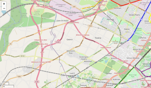
[[File:Tovena 14 Aug 22.png|thumb|500px|Tovena area in August 2022]] | [[File:Tovena 14 Aug 22.png|thumb|500px|Tovena area in August 2022]] | ||
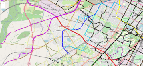
[[File:Tovena 3 Dec 22.png|thumb|500px|Tovena area in December 2022]] | |||
To give further context, the southwest region of Gobras City is being developed from a blank slate since August 2022 (initiated by Chazeltine). The [https://opengeofiction.net/#map=14/20.6549/86.5641&layers=B Kilmeade-Tovena area] is currently under development by {{OGF user|Chazeltine}}, {{OGF user|Squizie3}} and {{OGF user|Dono87}}. Previously, to quote from dono, "there seems to be an intent to stop development at district limits which does [sic] not seem reasonable. It seems we are also just attached to the inertia of the map when realistically there should be Easky-style suburbs south and west too." It's a flat region, ripe for development, even some predating Worldport (which seemed to be a more recent development around the 70s or 80s). | To give further context, the southwest region of Gobras City is being developed from a blank slate since August 2022 (initiated by Chazeltine). The [https://opengeofiction.net/#map=14/20.6549/86.5641&layers=B Kilmeade-Tovena area] is currently under development by {{OGF user|Chazeltine}}, {{OGF user|Squizie3}} and {{OGF user|Dono87}}. Previously, to quote from dono, "there seems to be an intent to stop development at district limits which does [sic] not seem reasonable. It seems we are also just attached to the inertia of the map when realistically there should be Easky-style suburbs south and west too." It's a flat region, ripe for development, even some predating Worldport (which seemed to be a more recent development around the 70s or 80s). | ||
Revision as of 00:32, 3 December 2022
Summary
|
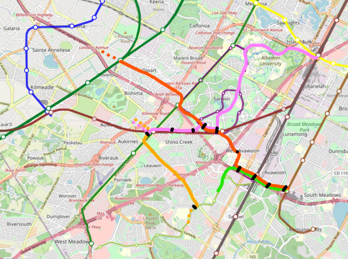
There has been discussion on Discord regarding new tram alignments in southwest Gobras City. The incongruous Sanavir Airtrain has been removed, with the area pending some rework based on what's agreed for the wider area. So, does the area require additional transport infrastructure?
But, why - is there a need? Would it be unrealistic, what would be the driver for such an infrastructure investment? wangi (talk) 22:42, 2 December 2022 (UTC) |
Loading map... railway, subway, tram, potential tram alignments? |
Discussion
Please share you thoughts, to try and build up consensus on this development. Thanks/wangi (talk) 22:42, 2 December 2022 (UTC)
To give further context, the southwest region of Gobras City is being developed from a blank slate since August 2022 (initiated by Chazeltine). The Kilmeade-Tovena area is currently under development by Chazeltine, Squizie3 and Dono87. Previously, to quote from dono, "there seems to be an intent to stop development at district limits which does [sic] not seem reasonable. It seems we are also just attached to the inertia of the map when realistically there should be Easky-style suburbs south and west too." It's a flat region, ripe for development, even some predating Worldport (which seemed to be a more recent development around the 70s or 80s).
Further quotings:
- Criticisms of the previous Sanavir tram system: On the other hand, most transit makes a deficit, but some deficits are recognizable as unsustainble uses of resources compared to other transit projects that might lose slightly less money.
- Gadget-bahns built as demonstration projects eventually get removed if they are only for show/tourists/events and don't have some sustainable element of local demand
- The Wuppertal Suspension Railway is the main linear transit mode for a highly linear city of 350k+ people in a narrow valley
- The Seattle Monorail was never expanded, but still connects Seattle's biggest transit center (Westlake) to more than just the Space Needle. The entire Seattle Center/Queen Anne area is quite dense by American standards
- Given the abundant green space (and golf course!! not a great transit trip generator..), unless each "Phailoon City/Kalabag/etc Circle" is comprised of 50-story highrises the size of Sim City arcologies, which is unlikely given that only a few schools are separately mapped, it is unlikely for the Sanavir Airtrain to be even defecit-level sustainable.
- And that would be the case for a single airtrain loop, which would be just as feasible in protected bus lanes if this were in fact a model community - let alone with the recent and partially tunneled extension to Avawoon, which would need to be redone
- The SW developments spread over a large area that should be filled with dense development but is lacking good transit, so with the right justification light rail could make sense in this area.
- The problem is that (the existing) systems are too disjointed to form a network effect with too many transfer penalties.
- This could be mitigated by branching off of the existing West Meadows-Avawoon tramway to the west, perhaps along Independence Blvd to the main Independence station (with Squizie's proposal to make it an even more important hub), and from there perhaps branches to Tovena and Galaria
- The "too many" in this area comes from the Sanavir Airtrain, with an odd routing, duplicating Line 2 and an awkward shoe-horned connection to Avawoon station, which is not designed to be a high-volume transfer hub and would need to be 'redesigned'. Why is the Airtrain even a separate mode? Sanavir doesn't even look that dense compared to other 'model communities' in GC
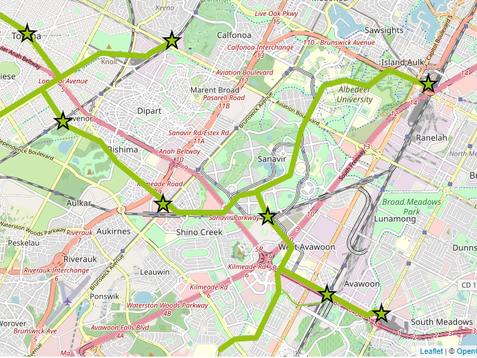
Here's a draft map of a possible tram system integrating SV Airtram with the existing tram running from West Meadows to Avawoon:
(Quoting from Dono) For Sanavir and Tovena/Galaria, they could both form part of an extended SW area tram network as an expansion of the existing M-Line.
- 1 or 2 lines through Sanavir and Albedeer University leading to the massive metro/rail hub at Isaulk-Broad meadows as an effective circulator. From Avawoon and potentially a second from Galaria/Tovena through Old Tovena (which could be redrawn if it is in fact an 'old town)
- 1 or 2 lines from Galaria/Tovena along Independence Blvd (with TOD not empty fields) to the existing M-Line
- Perhaps retaining the existing M-Line and/or splitting destinations North to Avawoon East and South to West Meadows
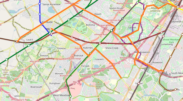
Other recent plan variants include:
As for now, I have set up the tram infrastructure by drawing tram tracks as according to Squizie's recent plan. The Kilmeade area is still in development, so the Shino Creek-West Meadows area (southeast of Kilmeade station) is the main focus for now. Further detailing, such as track configurations and curves, are to be done over time once tram plans are more finalised.
Existing transportation in the area https://wiki.opengeofiction.net/util/route_relations.html?map=C/13/20.61501/86.63928
