Forum:Request help/Vordum Sea revamp: Difference between revisions
Jump to navigation
Jump to search
(Adding proposal map for Vordum Sea) |
(Close topic) |
||
| (4 intermediate revisions by 4 users not shown) | |||
| Line 12: | Line 12: | ||
Many thanks, [[User:Aiki|Aiki]] ([[User talk:Aiki|talk]]) 15:21, 11 December 2021 (UTC) | Many thanks, [[User:Aiki|Aiki]] ([[User talk:Aiki|talk]]) 15:21, 11 December 2021 (UTC) | ||
: [[File:Vordum Sea Aiki Option 1.svg|thumb|right| | : [[File:Vordum Sea Aiki Option 1.svg|thumb|right|250px]] | ||
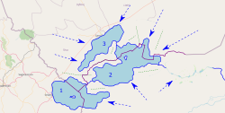
: Here's a proposal for Vordum Sea revamp. The lake is split into 3 "smaller" ones with Ohemia current shores kept as are most of Buçon's (where mapping artefacts are present (e.g. cities, roads). Green lines are for potential ridges and blue arrows are for the general direction of watercourses. Lakes 1 and 3 empty into Lake 2 that empties into the Asperic Ocean via the large existing river (a section would be added to connect it). | : Here's a proposal for Vordum Sea revamp. The lake is split into 3 "smaller" ones with Ohemia current shores kept as are most of Buçon's (where mapping artefacts are present (e.g. cities, roads). Green lines are for potential ridges and blue arrows are for the general direction of watercourses. Lakes 1 and 3 empty into Lake 2 that empties into the Asperic Ocean via the large existing river (a section would be added to connect it). | ||
: Feedback is welcome. --[[User:Aiki|Aiki]] ([[User talk:Aiki|talk]]) 20:58, 14 January 2022 (UTC) | : Feedback is welcome. --[[User:Aiki|Aiki]] ([[User talk:Aiki|talk]]) 20:58, 14 January 2022 (UTC) | ||
{{clear}} | |||
[[File:Screenshot 2022-01-14 4.38.25 PM.png|thumb|right|250px]] | |||
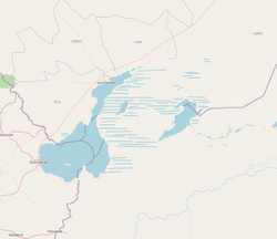
:: I meant to make a proposal for this earlier, my bad. This proposal is basically inspired partially by the Aral sea and the sea in Argentina that aiki shared. The blue area would be, of course, lake all year round. I've tried to keep year-round lake in the areas that seem to have the most inflow coming in. On the side of corpenia, there's a small lake remnant, connected to the larger lake body by either intermittent lake or marshes (possibly both). A bit simple, but I think it looks nice and the lake area could be cut down even further if needed. --[[User:Lithium|Lithium-Ion]] ([[User talk:Lithium|talk]]) 21:43, 14 January 2022 (UTC) | |||
I like the first proposal, not sure it's arid enough to support the second. /[[User:Wangi|wangi]] ([[User talk:Wangi|talk]]) 14:16, 15 January 2022 (UTC) | |||
:: One of the lake shores owners favours #1. I'm leaving some time to the second territory owner to reply before going forward with the changes. --[[User:Aiki|Aiki]] ([[User talk:Aiki|talk]]) 18:25, 23 January 2022 (UTC) | |||
::: Revamp [https://opengeofiction.net/changeset/1171122 uploaded]. --[[User:Aiki|Aiki]] ([[User talk:Aiki|talk]]) 20:10, 3 March 2022 (UTC) | |||
Latest revision as of 20:10, 3 March 2022
Forums → Request help or feedback → Request help/Vordum Sea revamp
Vordum Sea is that large endorheic lake in northeastern Antarephia. Its 26,137km2/10092 sq. mi. make it rather oversized for a body of water with no outflow in region with decent amount of precipitations (roughly similar South East of the USA or Rio de la Plata region).
I am reaching out to the OGF community to know if any mapper has ideas on how this sizing down should occur? This main condition being the rather detailed western coast (Ohemia) should be left untouched as much as possible).
- If the Vordum Sea remains endorheic, please consider something around 5,000km2 with maybe one or two additional "lower lakes" as terminal outflow. The closer RW example I have in mind is Mar Chiquita in Argentina.
- If the Sea is to be drained, please slightly enlarged version of the above with maybe more downstream smaller lakes. The easiest outflow would be through that large river in AN134e.
- Any other solution?
Many thanks, Aiki (talk) 15:21, 11 December 2021 (UTC)
- Here's a proposal for Vordum Sea revamp. The lake is split into 3 "smaller" ones with Ohemia current shores kept as are most of Buçon's (where mapping artefacts are present (e.g. cities, roads). Green lines are for potential ridges and blue arrows are for the general direction of watercourses. Lakes 1 and 3 empty into Lake 2 that empties into the Asperic Ocean via the large existing river (a section would be added to connect it).
- Feedback is welcome. --Aiki (talk) 20:58, 14 January 2022 (UTC)
- I meant to make a proposal for this earlier, my bad. This proposal is basically inspired partially by the Aral sea and the sea in Argentina that aiki shared. The blue area would be, of course, lake all year round. I've tried to keep year-round lake in the areas that seem to have the most inflow coming in. On the side of corpenia, there's a small lake remnant, connected to the larger lake body by either intermittent lake or marshes (possibly both). A bit simple, but I think it looks nice and the lake area could be cut down even further if needed. --Lithium-Ion (talk) 21:43, 14 January 2022 (UTC)
I like the first proposal, not sure it's arid enough to support the second. /wangi (talk) 14:16, 15 January 2022 (UTC)

