Forum:Territory application/AR915 – Bai Empire and Kanglapo
- Please fill in the information below to make a territory request.
| Territory ID and proposed name | |
|---|---|
| The Territory ID (from OpenGeofiction:Territories, e.g. AR123a) and proposed name of the country |
AR915 – Bai Empire and Kanglapo
| Physical geography | |
|---|---|
| An overview of climate, topography and landscape of the country. It is advised to also create a sketch, you can add a link to this (hosted on imgur or similar) |
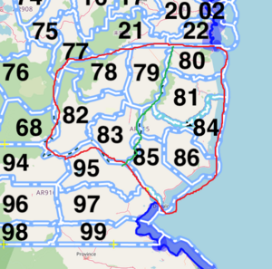
AR915 will be split into two territories. One is an extension of the existing Bai Empire, the other half by the east coast will be Kanglapo. The Bai extended region will be inspired by the Sichuan and Guizhou provinces.
An existing range will divide the two nations, shown by the green line. Wedged between the two nations, there will be a landlocked nation Kinglavia, an isolated nation similar to Bhutan but culturally similar to Kanglapo. Another inspiration could be Andorra, another microstate between Spain and France.
Generally, the region will be flat. The Bai side will be much similar to a valley, with rivers running parallel in a general northeast direction into Bai proper.
The Bai side will be heavily forested like the Sichuan and Guizhou provinces, with plenty of panda habitats alongside fertile lands and bamboo forests. Kanglapo will have similar geography, though less forested.
 | Human geography |
|---|---|
| A brief description of the territory demographics, economic development, land occupation, infrastructure and mapping style |
The sectors of 79 and 83 will be more heavily populated than 78 and 82. There might be a major municipality somewhere between 78 and 83, which is close to Kinglavia and is a common gateway between the two nations. It might be a historically important city, perhaps a former communist stronghold during Bai's political turmoil of the 30s and 40s. Generally, however, this part of Bai will be less developed.
Kanglapo is a "communist" nation, which saw plenty of industrial developments throughout its modern history (explaining the less forested area). Much of Kanglapo cities will be centrally planned, with a possible underground city dedicated for the country's scientific research. Its capital, Nandacheongfu, is located south and is a major city. Kanglapo will have a developed rail system to serve the country.
| History & culture | |
|---|---|
| A brief description of the intended culture and language |
The extended Bai region will be based off the cultures of Sichuan and Guizhou. Such influence will also be seen in Kanglapo known for its spicy food. Kanglapo speaks a unique conlang inspired by various Asian languages (Thai, Korean, Japanese), with a slight Slavic twist due to its past occupation by Suria. The language will use the Tai Lue script. Example: ᥢᥢᦡᥓᥥᥨᥒᥜᥪ Nandacheongfu; ᥛᥤᥒ ᥔ ᥞᥤᥒ Ming Sa Hing
Kanglapo was ruled by various warlords in the past, before control was centralised thanks to its status as a Bai tributary state. As the ruling Bai dynasty declined in the 17th century, the Kanglapolish region was handed to Suria (this has been discussed with the Surian mappers and they seemed fine with the idea) in exchange for some money. The Katayan people then fought for independence, briefly becoming a kingdom, then a republic, and a communist state in the early 20th century. It was invaded by Bai in the 30s and 40s during the War of Fellow Brothers. After the war, the ruling dictator died, and was suceeded by Li Ching Sam, who implemented economic reforms that explained its rapid modern infrastructural developments today.
| Past mapping | |
|---|---|
| To support your request provide links to areas of OGF mapping which showcase your mapping skill. Mapping relevant to the requested theme & geography is especially useful | |
| The {{coord}} template can optionally be used to link to the OGF map - it results in a nice formatted link. Or you can paste in a URL. |
Mapper of Kuehong
Coordinator of the Bai Empire
Gobrassanya
- Bai Quarter
- Helped fixed some bus routes and metro relations in Gobras City
- Commercial development at Plantationside
- Danhduong locomotive assembly plant
| Username & date | |
|---|---|
| Sign and date the application by typing four tildes like this: ~~~~ |
Zhenkang (talk) 12:45, 18 February 2022 (UTC)
 | Discussion |
|---|---|
| Discussion for clarification & decision |
- I will suggest that you take the entire AR915 as your own as a part of the Bai empire. The countries in Opengeofiction is already quite small in real world's standards, and one more mini nation in this region will prb makes anything a lil bit less verisimilitudinous, if not more.Poweikao (talk) 18:33, 19 March 2022 (UTC)
- ^^ This is exactly the concern that I raised with ZhenKang before, but seeing that Kanglapo is ZK's pet project since forever, I would not object to its inclusion here. In addition, Huaxia will now border AR915 and the communist continuity can actually fit into the overall theme of the area. A micro nation like Kinglavia would also be fun to map, and I trust ZK's ability to make lore so that it would make sense for its inclusion. Kengoman (talk) 21:07, 20 March 2022 (UTC)
