Forum:Territory application/UL15g+UL15i — restarting Podolian Republic (Podolia) and expanding its land area: Difference between revisions
mNo edit summary |
Bixelkoven (talk | contribs) No edit summary |
||
| Line 57: | Line 57: | ||
{{territory application closed|Not enough mapping on present territory for an expansion|We are unsure why did you decide to delete all your present mapping before the request, so could we get an explanation for that sudden action? With these terms, you do not have enough mapping on your territory that would warrant an expansion. We will close your application, but it can be reused when you fill out your current territory to an acceptable level. [[User:Bixelkoven|Bixelkoven]] ([[User talk:Bixelkoven|talk]]) 20:08, 18 April 2023 (UTC)}} | |||
Revision as of 20:08, 18 April 2023
- Please fill in the information below to make a territory request.
| Territory ID and proposed name | |
|---|---|
| The Territory ID (from OpenGeofiction:Territories, e.g. AR123a) and proposed name of the country |
Podolian Republic (full official name), Podolia (short common name). OGF IDs are UL15g (old territory) and UL15i (new territory).
| Physical geography | |
|---|---|
| An overview of climate, topography and landscape of the country. It is advised to also create a sketch, you can add a link to this (hosted on imgur or similar) |
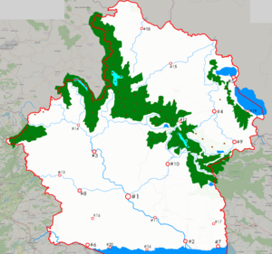
The country is located on the northern shore of Egalian lake and borders Chira on the south-west, Dregovine on west, Geklinia-Dregolesia on north-west, UL14d on north, UL14e on nort-east and Ul15x on east. The general overview of geography is presented on the right.
The two major mountain chains are the Copper Mnts on the Gek.-Dreg. border and XXX mountains stretching from NW to SE, serving as the main watershed dividing country into two major parts. The heights there reach up as high as 2700 m.
Southern part of Podolia is characterized as forest-steppe with warm summers and cool, sometimes frosty, winters. It is the main agriculture part of country and it is dominated by XX river basin. The extreme southeastern region drains into Ina river which flows from Egalia into Great Rift Sound.
The northern part is significantly harsher climate-wise, as the weather here is dominated by air masses from Northern Ocean and southern warm winds are blocked by the main mountain chain. The two cool features here are big lakes on the border with UK14e.
 | Human geography |
|---|---|
| A brief description of the territory demographics, economic development, land occupation, infrastructure and mapping style |
The population of Podolia is about 7.5-8 M people. By the reasons explained above, ~80% of population (6-6.5M) are going to live in the southern part of Podolia. I placed approximate locations of 20 biggest cities and towns on the map. The capital is the biggest city and it is going to have approx. 800k inhabitants.
Podolia is mostly a mono-ethnic nation with >93% being podolians. National minorities exist close to the borders. There's also a significant diaspora in the neighbouring countries.
Mapping style will be close to northern Ukraine and Belarus, also probably Baltic states. By the level of economic development Podolia is like RW Latvia, Lithuania.
| History & culture | |
|---|---|
| A brief description of the intended culture and language |
Podolians belong to northern branch of Velitic nations (a.k.a. OGF-Slavic, Slevic (bs name) or whatever). The language is quite close to Dregovinian and especially Dregolesian. In terms of real-world languages, podolian is going to be mostly based on Ruthenian and written with latin script.
Historically it was quite often a part of larger empires (geklinian, lanian, surian) but also has long periods as independent kingdoms and later as independent republic. Podolia was one of the first nations in Uletha to adapt the republican form of government. It happened after gaining independence in 1804.
In 1933 Podolia, as a result of revolutional events, became a socialist state and a close ally to Suria, including the Great War. In 1996 the past regime lost power to various protests and demonstrations, sometimes known as xxx revolution. Podolia is a developing liberalized democracy since then. It maintains friendly ties with Suria however, neutral with both Dregovine and Dregolesia (however many issues of Zamednovian Podolians in G-D are still a subject in mutual relations), and now is leaning towards strengthening friendship with other Egalian Nations. Podolia joined Egalian Union in ~2003.
| Past mapping | |
|---|---|
| To support your request provide links to areas of OGF mapping which showcase your mapping skill. Mapping relevant to the requested theme & geography is especially useful | |
| The {{coord}} template can optionally be used to link to the OGF map - it results in a nice formatted link. Or you can paste in a URL. |
Karzalia, Suria. https://opengeofiction.net/#map=8/51.768/81.782&layers=B
Mirgorod, Suria. https://opengeofiction.net/#map=12/54.3936/72.9334&layers=B
old Podolia.
various little mapping in some other places. [1] [2] [3]
| Username & date | |
|---|---|
| Sign and date the application by typing four tildes like this: ~~~~ |
Thermo nuclear (talk) 15:34, 16 April 2023 (UTC)
 | Discussion |
|---|---|
| Discussion for clarification & decision |
| Territory application closed | |
|---|---|
| Not enough mapping on present territory for an expansion | |
| We are unsure why did you decide to delete all your present mapping before the request, so could we get an explanation for that sudden action? With these terms, you do not have enough mapping on your territory that would warrant an expansion. We will close your application, but it can be reused when you fill out your current territory to an acceptable level. Bixelkoven (talk) 20:08, 18 April 2023 (UTC) |

