Weekly site maintenance is scheduled Thursday 04:00–06:00 UTC.
Editing will not be possible during this time, and there may be other brief disruptions. (additional info)
Ingerish Asperia: Difference between revisions
m (FIX typo) |
|||
| (102 intermediate revisions by 4 users not shown) | |||
| Line 1: | Line 1: | ||
{{disambig|the province of [[Deodeca]]|the [[Collab:Deodeca/Ingerish Asperia|collaboration page]]|x}} | {{disambig|the province of [[Deodeca]]|the [[Collab:Deodeca/Ingerish Asperia|collaboration page]]|x}} | ||
{{Infocard | {{Infocard Deodeca | ||
| name = Province of Ingerish Asperia | | name = Province of Ingerish Asperia | ||
| flag = IA_ProvinceFlag.png | | flag = IA_ProvinceFlag.png | ||
| symbol =IA_CoatOfArms.png | | symbol =IA_CoatOfArms.png | ||
| symbol_caption =Coat of arms of Ingerish Asperia | | symbol_caption = Coat of arms of Ingerish Asperia | ||
| native_name = | | native_name = Speshxen | ||
| native_language = | | native_language = Tshayhamhash | ||
| capital = New Reydon | | capital = New Reydon | ||
| population = 10,100,550 | | population = 10,100,550 | ||
| population_year = 2022 | | population_year = 2022 | ||
| motto = | | motto = "Illustratio, Moralis, Prudentia." ("''Englightenment, Morality, Prudence''.") | ||
| anthem = | | anthem = ''No official anthem'' | ||
| latitude = -36.666 | | latitude = -36.666 | ||
| longitude = | | longitude = 130.9 | ||
| zoom = | | zoom = 6 | ||
| relation = 949 | | relation = 949 | ||
| intro = '''Ingerish Asperia''' | | intro = '''Ingerish Asperia''' (abbreviated as '''IA''' and also known as '''Asperia''') (Tshayhamhash:''Speshxen/spə́ɬx̣ən)'' is the northernmost constituent province within the [[Deodeca|Commonwealth of Deodeca]]. Ingerish Asperia features a very diverse geography and hydrography, mainly due to its extensive coastline. It features high-alpine mountains, subtropical wet forests, rolling plains, and temperate forests. Asperia is one of the most populated provinces, with 10.1 million people, most of them being within the three major metropolitan areas. Namely, these are [[New Reydon]], Baptist Bay, and Stonesipher. Ingerish Asperia shares land borders with the province of [[Kastichetshan]] to the south and an international border to the west with TBD. | ||
The largest city | The capital, New Reydon, is rooted in its rich educational and cultural institutions: it is often referred to as the "Scholar Capital". Baptist Bay and the largest city, Stonesipher, both share similar histories as important naval and shipping centers. | ||
The | }} | ||
==Etymology== | |||
{| style="float:left; width:25em; margin:1em; border:1px solid grey; padding:5px; background:beige; text-align:center;" | |||
|- | |||
| align=center | '''Native Names for Ingerish Asperia''' | |||
|- | |||
| Tshayhamhash: ''Speshxen/spə́ɬx̣ən'' <!--Ground, land--> | |||
|- | |||
| Alhqwawt: ''Pq-aqtkwa'' <!--White lake--> | |||
|- | |||
| Aqsmaknik: ''Aqisqnuk'' <!--Two lakes, windermere.--> | |||
|- | |||
|} | |||
The Colony was named Ingerish Asperia was named by Queen Charlotte in 1700. The name "Asperia" refers to the historic Ulethan name for the southwest coast of Astrasia (itself taken from the Asperic Ocean). The prefix "Ingerish" was added to differentiate it from extensive Franquese claims to the south.<ref>Appleby, S. (1987) ''History of the Colony of Ingerish Asperia: 1700-1800''. Reydon House Publishing''</ref> | |||
==History== | |||
===Prehistory=== | |||
Several nomadic tribespeople established themselves in the area, having migrated north from the central plains. Over time, these tribespeople seperated, through geography and internal divisions, and formed seperate distinct groups. These peoples developed strong and unique connections to the land. | |||
Before the colonization of Asperia, the land was inhabited by several indigenous tribes such as the Tshayhamhash, Squamish, and other tribes of the North First Nations, a group of aboriginals native to Ingerish Asperia and Kastichetshan. These tribes had their own unique cultures, traditions, and languages, but they all shared a deep respect for the natural world.<ref>Sinclair, M.S. (1978) ''Stories from the North First Nations''. Indigenous Society Journal</ref> | |||
These indigenous peoples developed their culture around the unique landscapes of the area. Moose and deer skin were used for clothing, tents, and for canoes. The many riverways of Asperia were utilized through canoes, allowing indigenous peoples to travel with relative speed. The abudance of resources and wildlife provided plentiful resources for indigenous peoples - their culture developed around the notion of sustainable hunting practices, with specific times during the year to hunt and animal numbers monitored. | |||
Music, art, and food became strong cultural elements that developed over time. Music often included vocalizations and beats played with sticks hit upon a carved log instrument. Many of these peoples used music as a method of conveying stories and folklore. Art was used through woodcarving, painting, and skin tattoos to display tribal pride, identity, and shared history. Food such as berries, fish, meat, and starchy vegetables were used to make rudimentary dishes that were tied to the natural environment. Pottery and claymaking were also important for practical purposes but also for artwork. | |||
===Ingerish colonisation=== | ===Ingerish colonisation=== | ||
===Colonial period=== | ===Colonial period=== | ||
===Provincehood=== | ===Provincehood=== | ||
| Line 53: | Line 54: | ||
{{Infobox geography | {{Infobox geography | ||
| name = Ingerish Asperia | | name = Ingerish Asperia | ||
| continent = Archanta | | continent = Archanta (Southern) | ||
| region = | | region = Astrasia | ||
| population = 10, | | population = 10,000,000 | ||
| population_year = | | population_year = 2023 | ||
| area_km2 = | | area_km2 = 112,493.81 | ||
| area_sq_mi = | | area_sq_mi = 43,434.10 | ||
| percent_water = 1 | | percent_water = <1% | ||
| density_km2 = | | density_km2 = 88.89 | ||
| density_sq_mi = | | density_sq_mi = 230.2 | ||
| custom_label1 = | | custom_label1 = Major rivers | ||
| custom1 = | | custom1 = Saint Agnes, Hale, Tidon, Umbra, Asperia | ||
| | | time_zone = WUT+09:00 (CDT) | ||
}} | }} | ||
===Climate=== | ===Climate=== | ||
===Hydrology=== | ===Hydrology=== | ||
== Government and Politics == | == Government and Politics == | ||
{{Infobox government | {{Infobox government | ||
| name = Ingerish Asperia | | name = Ingerish Asperia | ||
| government_type = Constitutional parliamentary monarchy | | government_type = Constitutional parliamentary monarchy | ||
| capital = New Reydon | | capital = New Reydon | ||
| title1 = | | title1 = King | ||
| hos1 = Geoffrey VII | | hos1 = Geoffrey VII | ||
| title2 = | | title2 = Governor | ||
| hos2 = Graham Archehurst | | hos2 = Graham Archehurst | ||
| legislature = Parliament | | title3 = Lieutenant-Governor | ||
| upper_house = | | hos3 = Peter McConochie | ||
| upper_house_diagram = | | legislature = Ingerish Asperian Parliament | ||
| upper_house = House of Council | |||
| upper_house_diagram = IA Upperhouse.svg | |||
| lower_house = House of Assembly | | lower_house = House of Assembly | ||
| lower_house_diagram = | | lower_house_diagram = IA Lower house.svg | ||
| judiciary = Supreme Court | | judiciary = Supreme Court of Ingerish Asperia | ||
| custom_label1 = | | custom_label1 = | ||
| custom1 = | | custom1 = | ||
| political_parties = {{legend|# | | political_parties = {{legend|#3F5FDF|Liberals}}{{legend|#DF3D3D|Labour}}{{legend|#FF9A27|Asperian Action Party}}{{legend|#5FC03C|Natural Party}} | ||
}} | }} | ||
=== | ===Administrative divisions=== | ||
''Main article: [[Administrative_divisions_of_Ingerish_Asperia|Administrative divisions of Ingerish Asperia]]'' | |||
| | |||
==Economy== | ==Economy== | ||
==Transportation== | |||
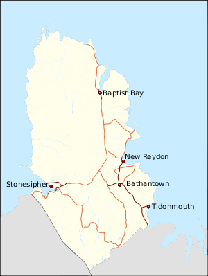
[[File:IA Transportation Map.svg|thumb|left|Map of major highways in Asperia.]] | |||
| | ===Roadways=== | ||
| | ===Railways=== | ||
| | ===Ferries=== | ||
==Demographics== | ==Demographics== | ||
{{Infobox demography | {{Infobox demography | ||
| name = Ingerish | | name = Ingerish Asperia | ||
| demonym = Ingerish Asperian, Asperian (''more common'') | | demonym = Ingerish Asperian, Asperian (''more common'') | ||
| official_languages = Ingerish | | official_languages = Ingerish | ||
| minority_languages = | | minority_languages = Tshayhamhash/ƛ̕ay̕əm̕áɬ, Aqsmaknik, Lumxemx, Native Archantan languages | ||
}} | }} | ||
===Health=== | ===Health=== | ||
| Line 272: | Line 115: | ||
===Languages=== | ===Languages=== | ||
===Religion=== | ===Religion=== | ||
==Culture== | ==Culture== | ||
===Symbols=== | ===Symbols=== | ||
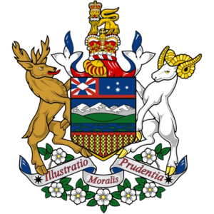
[[File:IA CoatOfArms.png|300px|thumb|left|The coat of arms of Ingerish Asperia. It features the Ingerish crown on the crest, Liedbeck's mountain goat as a supporter, a Red deer as a supporter, and a White mobgray laurel on the bottom.]] | |||
{| class="wikitable" | |||
|+ Symbols of Ingerish Asperia<ref>''Symbols Act 1995'' (IA) s1-7.</ref> | |||
|- | |||
! Type !! Name !! Image | |||
|- | |||
| Mammal || Liedbeck's Mountain goat (''Oreamnos leidbeckis'') || | |||
[[File:New Mexico Bighorn Sheep.JPG|100px|framless]] | |||
|- | |||
| Bird|| White-tipped stormpetrel (''Hydrobates asperinus'') || | |||
[[File:Leach's Storm-petrel Saint-Jean-de-Monts 02.jpg|100px|frameless]] | |||
|- | |||
| Fish || River Agnes trout (''Oncorhynchus agnii'') || | |||
[[File:Salmo trutta.jpg|100px|frameless]] | |||
|- | |||
| Flower || White mobgray (''Vinca hepburnii'') || | |||
[[File:Cornus nuttallii 135664560.jpg|100px|frameless]] | |||
|- | |||
| Song || Hunker down Asperia || [[File:The Kings Breakfast - sheet music 006.png|100px|frameless]] | |||
|- | |||
| Mineral || Copper || | |||
[[File:NatCopper.jpg|100px|frameless]] | |||
|- | |||
| Colours || Red, blue, white, gold || | |||
[[File:IA ProvinceFlag.png|100px|frameless]] | |||
|} | |||
===Sports=== | ===Sports=== | ||
==Notes== | ==Notes== | ||
==See | ==See also== | ||
* [[Deodeca]] | * [[Deodeca]] | ||
| Line 298: | Line 154: | ||
{{Political divisions of Deodeca}} | {{Political divisions of Deodeca}} | ||
[[Category: | [[Category:Ingerish Asperia]] | ||
[[Category:Provinces of Deodeca]] | |||
Latest revision as of 11:22, 25 December 2023
 This encyclopedia article is about the province of Deodeca. You may be looking for the collaboration page.

|
Province of Ingerish Asperia Speshxen (Tshayhamhash) Capital: New Reydon
Population: 10,100,550 (2022) Motto: "Illustratio, Moralis, Prudentia." ("Englightenment, Morality, Prudence.") |
Loading map... |
Ingerish Asperia (abbreviated as IA and also known as Asperia) (Tshayhamhash:Speshxen/spə́ɬx̣ən) is the northernmost constituent province within the Commonwealth of Deodeca. Ingerish Asperia features a very diverse geography and hydrography, mainly due to its extensive coastline. It features high-alpine mountains, subtropical wet forests, rolling plains, and temperate forests. Asperia is one of the most populated provinces, with 10.1 million people, most of them being within the three major metropolitan areas. Namely, these are New Reydon, Baptist Bay, and Stonesipher. Ingerish Asperia shares land borders with the province of Kastichetshan to the south and an international border to the west with TBD.
The capital, New Reydon, is rooted in its rich educational and cultural institutions: it is often referred to as the "Scholar Capital". Baptist Bay and the largest city, Stonesipher, both share similar histories as important naval and shipping centers.
Etymology
| Native Names for Ingerish Asperia |
| Tshayhamhash: Speshxen/spə́ɬx̣ən |
| Alhqwawt: Pq-aqtkwa |
| Aqsmaknik: Aqisqnuk |
The Colony was named Ingerish Asperia was named by Queen Charlotte in 1700. The name "Asperia" refers to the historic Ulethan name for the southwest coast of Astrasia (itself taken from the Asperic Ocean). The prefix "Ingerish" was added to differentiate it from extensive Franquese claims to the south.[1]
History
Prehistory
Several nomadic tribespeople established themselves in the area, having migrated north from the central plains. Over time, these tribespeople seperated, through geography and internal divisions, and formed seperate distinct groups. These peoples developed strong and unique connections to the land.
Before the colonization of Asperia, the land was inhabited by several indigenous tribes such as the Tshayhamhash, Squamish, and other tribes of the North First Nations, a group of aboriginals native to Ingerish Asperia and Kastichetshan. These tribes had their own unique cultures, traditions, and languages, but they all shared a deep respect for the natural world.[2]
These indigenous peoples developed their culture around the unique landscapes of the area. Moose and deer skin were used for clothing, tents, and for canoes. The many riverways of Asperia were utilized through canoes, allowing indigenous peoples to travel with relative speed. The abudance of resources and wildlife provided plentiful resources for indigenous peoples - their culture developed around the notion of sustainable hunting practices, with specific times during the year to hunt and animal numbers monitored.
Music, art, and food became strong cultural elements that developed over time. Music often included vocalizations and beats played with sticks hit upon a carved log instrument. Many of these peoples used music as a method of conveying stories and folklore. Art was used through woodcarving, painting, and skin tattoos to display tribal pride, identity, and shared history. Food such as berries, fish, meat, and starchy vegetables were used to make rudimentary dishes that were tied to the natural environment. Pottery and claymaking were also important for practical purposes but also for artwork.
Ingerish colonisation
Colonial period
Provincehood
20th century
21st century
Geography
 | |
|---|---|
| Geography of Ingerish Asperia | |
| Continent | Archanta (Southern) |
| Region | Astrasia |
| Population | 10,000,000 (2023) |
| Area | |
| • Total | 112,493.81 km2 43,434.10 sq mi |
| • Water (%) | <1% |
| Population density | 88.89 km2 230.2 sq mi |
| Major rivers | Saint Agnes, Hale, Tidon, Umbra, Asperia |
| Time zone | WUT+09:00 (CDT) |
Climate
Hydrology
Government and Politics
| Government of Ingerish Asperia | |
|---|---|
| Constitutional parliamentary monarchy | |
| Capital | New Reydon |
| Head of state | |
| • King | Geoffrey VII |
| • Governor | Graham Archehurst |
| • Lieutenant-Governor | Peter McConochie |
| Legislature | Ingerish Asperian Parliament |
| • Upper house | House of Council |
| • Lower house | House of Assembly |
| Judiciary | Supreme Court of Ingerish Asperia |
Major political parties | |
Liberals Labour Asperian Action Party Natural Party | |
Administrative divisions
Main article: Administrative divisions of Ingerish Asperia
Economy
Transportation
Roadways
Railways
Ferries
Demographics
| Demographics of Ingerish Asperia | |
|---|---|
| Demonym | Ingerish Asperian, Asperian (more common) |
| Official languages | Ingerish |
| Recognized minority languages | Tshayhamhash/ƛ̕ay̕əm̕áɬ, Aqsmaknik, Lumxemx, Native Archantan languages |
Health
Education
School list
Ethnicity
Languages
Religion
Culture
Symbols
| Type | Name | Image |
|---|---|---|
| Mammal | Liedbeck's Mountain goat (Oreamnos leidbeckis) | |
| Bird | White-tipped stormpetrel (Hydrobates asperinus) | |
| Fish | River Agnes trout (Oncorhynchus agnii) | |
| Flower | White mobgray (Vinca hepburnii) | |
| Song | Hunker down Asperia | 
|
| Mineral | Copper | |
| Colours | Red, blue, white, gold |
Sports
Notes
See also
| Provinces | |
|---|---|
| Capital District | Odeka District |


