OpenGeofiction:Coastline maintenance
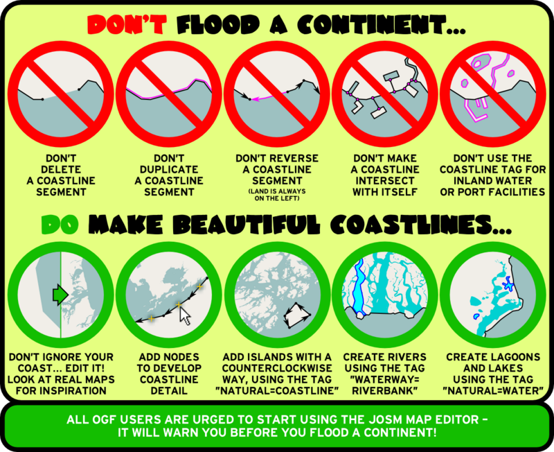
Maintaining coastline integrity is important because when there are gaps or mistakes in the coastline, it creates rendering problems on the map, which look like giant "floods." Everyone should be careful with the natural=coastline tag. Unlike with other tags, please do not just "play with" coastline tags to experiment with "how it might look" - the map renderer handles coastline tags differently, and mistakes can appear on the world map for several hours, even if they are fixed right away.
The "too many nodes" Problem
The OSM standard does not allow more than 2000 nodes in a coastline way (or any way, for that matter, but it's a problem most commonly seen with coastlines). The solution to the problem is simple - you just "split" the way into two ways, connect end-to-end. This is a single step in JOSM. If you start with a single coastline way, you can select an individual node and then use the "split way" feature (keyboard shortcut "P"). Done!
Troubleshooting the "Flooding" Problem
It can be quite difficult, however, to find the exact location of the cause of a "flooding" problem. To help with that, the following very useful map overlay has been created, which displays nodes where the coastline is broken in some way (go here for a larger version):
Loading map...
You can click on a marker in that map to see more information about the related node. A full discussion of how to maintain coastlines can be found on the openstreetmap wiki. A very short summary is that nodes must be:
- a member of exactly one such way, either as an interior point or as its combined start and end point (if the way is closed) or
- a member of exactly two ways, where it is the start point of one and the end point of the other
- nodes that do not meet this condition are displayed on the coastline_info map. Obviously they don't always cause a rendering problem, but in the case of major flooding you will probably find the problematic location among them.
In the case of a continent flooding, you're all - especially the more experienced users - called upon to try to fix it. Because it is important, it is justified to make an edit in another user's territory if you see a coastline problem.
Lakes and Inland Seas
There are some lakes and seas in Openstreetmap that are tagged as natural=coastline. This has been deprecated. Quoting from the OSM wiki:
- Before multipolygon relations were added to OSM, some large lakes were also tagged with natural=coastline, but most of them have been converted. Currently there are a few large lakes left (like the Great lakes), that still use this tag. Because of the complexity and size of these lakes, this tagging is difficult to change, so they might stay this way for the time being. But you should not introduce any new inland water areas that are tagged this way.
If you draw large lakes and inland seas, best practice seems to be to use natural=water / water=lake, either as a simple closed way or as a multipolygon relation. I prefer the later... then you can treat the individual lakeshore ways more or less the same way you treat ocean coastline ways.
A Visual Summary
Here is a great graphic that summarizes OGF coastline work.
