Qennes: Difference between revisions
Bixelkoven (talk | contribs) |
Bixelkoven (talk | contribs) |
||
| Line 83: | Line 83: | ||
<gallery mode=packed caption="Landscapes of Qennes"> | <gallery mode=packed caption="Landscapes of Qennes"> | ||
File:Malinik_Mountain.jpg|Apyn mountains | File:Malinik_Mountain.jpg|Apyn mountains, Kaneș al Kaț | ||
File:Grotte del bue marino dorgali o.jpg|Coastal grottoes | File:Grotte del bue marino dorgali o.jpg|Coastal grottoes in Feră Empodia, Malvertta | ||
File:Mons, Hérault 02.jpg|Lavand Mountains near | File:Mons, Hérault 02.jpg|Lavand Mountains near {{node|07739527|Liud}}, Dadaş - Kopiță | ||
File: | File:QNMtn.png|{{way|2344360|Montă river}} valley, Kaneș - Montă | ||
File:Massif_de_Coutach.jpg| Massif near Ogașu Galbină | File:Massif_de_Coutach.jpg| Massif near {{node|179130271|Ogașu Galbină}}, Prață | ||
File: | File:Montserrat 29 - panoramio.jpg|{{node|250470067|Filin mountain}} near Manastîr Valas, Kaneș - Montă | ||
File: | File:Aerial view of the beach of Bonporteau in the Côte d’Azur region, France (51695870655).jpg|Coastal area near {{node|186883672|Plaẓa Ketne}}, Este | ||
File:Salt_evaporation_ponds_in_Gu%C3%A9rande,_France,_October_2018_(34).jpg| Salterns in {{node|228020037|Viletta}} | File:Salt_evaporation_ponds_in_Gu%C3%A9rande,_France,_October_2018_(34).jpg| Salterns in {{node|228020037|Viletta}}, Erez | ||
File:Views of the Mediterranean (7023395785).jpg| | File:Views of the Mediterranean (7023395785).jpg| Cliffs in Feră Empodia, Este | ||
</gallery> | </gallery> | ||
Revision as of 21:32, 13 July 2022

|
Qennes  Arkiduțiă Kaneșului (Qennesan) Archidoucatul Quenneʃ (Romanish) Arkidukat Kenes (Eganian) Kanıs Arşidüklüğü (Turquese) Kryedukati i Kenes (Malësorian) Arȿiḏucijȁ Ḵenɘs (Poyan) Capital: Arta
Population: 3,006,380 (2022) Motto: Iața Kaneșienii Anthem: Frumosă noastră ḑintre Lină Tîrdau șî Mar Iviran |
Loading map... |
Qennes (/kɛnes/, pronounced: KE-nes; Qennesan: Kaneș, pronounced: [känɛʂ], KA-nesh), officially The Qennesan Archduchy (Qennesan: Arkiduțiă Kaneșului), is a sovereign state in central-southern Uletha∈⊾. It is bordered by Malësoria to the west, Antharia to the north and east, and Niscavo to the southeast. It also borders the Demirhan Empire to the south via the Bay of Erez, part of the Iviran Sea∈⊾ on which Qennes has its southern shores, while the northwestern shores are located on the Lake Sens∈⊾. The capital city is Arta located in the southwest of the country, while the largest city is Malvertta.
Originally an area inhabited by various tribes of many origins, most notably the Moorsh, but also the Kartlegian, Malesor, Po'ion, Semic and Slevic people groups, Qennes emerged from the remnants of the Hellanesian colonial period in the Iviran Sea region as a duchy in the 2nd century AD. It encompassed the coastal regions of modern Qennes centered around the cities of Molokortia and Erulgi (modern day Malvertta and Porterez, respectively) which dominated the cross-Ulethan trade flow in the region. Until the 15th century, Qennes' boundaries would constantly change under various conquests and wars. Eventually the Eganian nations to the east would take over the Qennesan coast and push it inland. With the beginning of the 15th century, the Qennesan duchy gained a large influential presence of the Romanish culture, which would completely reshape the Hellanesian-influenced culture of Qennes. In 1427, led by duke Aleksandru I Poraș 'the Stalwart', a new Qennesan nation was born and a new national identity. Aleksandru would triple the size of his nation and reform his title into an archduke.
In the late 18th century Qennes would see itself transform into an elective monarchy from an absolute one, after the Rebellion of Artei. It went through the revolutionary, rennaisance, industrial and Great War eras with its lands mostly intact, with an emphasis on economic growth, with its independence guaranteed and protected by the Antharian Kingdom for most of the timeline. It entered the 20th century as a very unequal country in terms of individual economic power and a population half its size nowadays. Pushed by industrialization, and later the modern socio-economical revolution, Qennes rose to being one of the wealthiest nations globally. Nowadays, Qennes is an elective monarchy ruled by an archduke, a developed and high living standard country with a high-income, social market economy. It is a member of the Association of South Ulethan Nations, after joining in 19xx, and has signed numerous agreements with its neighbors and beyond. Qennes has a population of about 3 million people which is spread out on 9,846 square kilometers, making it one of the most densely populated countries in both south Uletha and the whole world.

Etymology
The name Qennes is the Ingerish version of the native name Kaneș. The name 'Qennes' gets its roots from the Romanish name for the coastal area west of Niscavo - Quenneʃ.
Kaneș, as a name, has no certain etymology although there are two possible answers. During the Hellanesian colonization of the coast west of Niscavo, the area was uninhabited upon arrival. It is thought that the colonizers named the region Keno, Kene, Kenos or either Kenes, all of which derive from the Hellanesian word keno, meaning "empty". It is considered that the name eventually became the name of the Hellanesian subdivision in the area.
Another suggestion is that the name was derived from the phrase 'Kan nisi' , which means "possibly an island" in Hellanesian. It is thought that the colonizers have mistaken the peninsula in nowadays Malvertta for an island, or were either uncertain if it is either of the two.
The name Kaneș was first recorded in 1427 when Qennes' borders where roughly at the lines with nowadays Lipămontală∈⊾ province. Before that date, Qennes was known as 'Kenes' by the Hellanesians, 'Quenneʃ' by the Romanish and 'Kanis' by the Turquese. Since 1427 the name has remained unchanged.
History
Prehistory
Early history
Hellanesian colonization era
Independence years
Post-Independence years
Darazdinian state
Antharian Kingdom
Medieval Era
Anagenisi Period
Romanish invasion
Neo-Hellanesian colonization era
Early modern era
Great War era
Modern era
Geography
 | |
|---|---|
| Geography of Qennes | |
| Continent | Uletha (Western) |
| Region | Iviran Coast |
| Population | |
| Area | |
| • Total | 10,363.18 km2 4,001.25 sq mi |
| • Water (%) | 6.68% |
| Population density | 290.1 km2 751.36 sq mi |
| Extreme points | Kunîla (1842 m) Iviran Sea∈⊾ (0 m) |
| Longest river Largest lake (by area) | Kaneș (x) Lake Omnikă (Lină Omnikă) (x) |
| Time zone | WUT +5 |
Qennes is situated on the continent of Uletha, in its central-southern region known as the Iviran Coast, by the Iviran Sea∈⊾. It lies between latitudes 41° and 40° N, and longitudes 83° and 84.5° E. The geographic center of Qennes is located west of the city of Dadaș, on the AP-3 highway, at the coordinates of 40.2462° N and 83.719° E, near the village of Brațaș.

Qennes is a moderately hilly nation, with two major mountain chains spanning east to west. They are the Lavand Mountains in the central areas of the country and the Apyn Mountains in the southeast, both of which span east into Antharia and Niscavo. The tallest peak, Kunîla, standing at 1842 meters, is located in the Apyn Mountains range on the tripoint of the municipalities of Kaneș-Montă∈⊾, Res∈⊾ and the country of Antharia. Most of the country is dominated by rolling hills, river valleys and flat plains. The three major plains in Qennes are the Koșteiu Plain, the Erez Plain, home to most of the agriculture activity, and the Qennesan Riviera Region - the most densely populated area in the country, as well as a tourist hotspot. The lowest point of Qennes is the Asperic Ocean at sea level (0m), with no stretches of land under sea level.
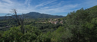
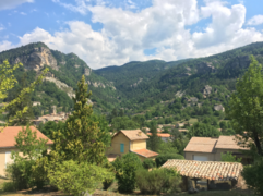
- Landscapes of Qennes

Apyn mountains, Kaneș al Kaț

Coastal grottoes in Feră Empodia, Malvertta
Lavand Mountains near Liud, Dadaş - Kopiță
Montă river valley, Kaneș - Montă

Massif near Ogașu Galbină, Prață

Filin mountain near Manastîr Valas, Kaneș - Montă

Coastal area near Plaẓa Ketne, Este

Salterns in Viletta, Erez

Cliffs in Feră Empodia, Este


.jpg)
.jpg)
.jpg)
Geology

Qennes is in a semi-active seismic zone. It lies near the active convergent boundary of the Asperic and East Ulethan plates.[1] There have been at least 50 destructive earthquakes in the past identified by scientists. There are numerous caves throughout Qennes, found throughout the hilly and mountainous regions of the country. In the Feră Empodia region, grottoes are a dotted along the cliffs. There are about 70 grottoes in Qennes. The rock composition is predominantly sedimentary, and the soil is favorable for year-round agricultural activity in every part of the country.
|
| ||||||||||||||||||||||||||||||||||||||||||||||||||||||||||||||||||||||||||||||||||||||||||||||||||||||||||||||||||||||||||||||||||||||||||||||||||||||||||||||||||||||||||||||||||||||||||||||||||||||||||||||||||||||||||||||||
Climate
As a rather small sized country, Qennes doesn't pose much diversity in climate. There are 2 climate zones in Qennes: 'Csa' encompasses most of the country, while the highest of mountains and peaks are classifed as 'Csb'. Qennes is characterized by dry summers and mild, wet winters.
The precipitation rate varies between 35mm and 94mm year round. The rainfall rarely exceeds 150mm during a month, and the average amount of rainfall is 64mm. Qennes receives about 3,712 hours of sunshine year round, with the numbers peaking at 384 hours in July. Such a climate has allowed Qennes to develop into a highly popular summer tourism destination.
Waters

All of Qennes' rivers belong to the Iviran Sea∈⊾ basin. They are either directly part of the drainage basin, or part of the Lake Sens∈⊾ drainage basin, which empties into the Iviran Sea via the Recz River in Antharia.
The longest river is the Kaneș River with a length of XXXm (XXXm of which is within the borders of Qennes). It has it source near the monastery of Pakras in western Antharia, flowing southwest towards the Bay of Erez where it meets the Iviran Sea next to the town of Porterez. On its course it flows through a few major cities and towns including Kallomenos (Antharia), Reța, Dadaș, Poiu, Arta, Erez, Porterez (Qennes) and Portilumës (Malësoria). Qennes has a low number of natural lakes and ponds. Besides the Lake Sens, the largest natural lake would be Lake Omnikă in the south of the country, created by a natural phenomenon of beavers constructing a dam on the Omnikă River strong enough to dam the small river. This enabled engineers to find the perfect spot for a dam.
Other natural lakes can be mainly found in the southwest, precisely oxbow lakes created by the Kaneș River and its meandering. The largest lake, besides the Lake Sens, is the Lîulină Reservoir, created artificially by the Lîulină Dam on the Kopiță River.

Biodiversity & Protected Areas


Qennes has a wide number of animal, plant and fungi species present in its territory. It is one of the most biodiverse countries in southern Uletha, proportional to its territory size. In 2008, Qennes brought a Biodiversity Recognition law into power, which revised the biodiversity situation in the country and set to protect endangered species, and control the human usage of natural resources of the nature. Alongside that, Qennes redefined its protected areas, and redefined the areas which are considered to be protected.
There are 3 main terrestrial biogeographical and eco-regions: Littoral, Lower Continental and Upper Continental. The Littoral regions is dominated by the Mediterranean biome, mainly hot and dry summers, and rainy and semi-rainy winters, forests and shrubs of lower density, plants which can be pyrophytes, numerous cases of the "mosaic habitat" and general drier scenery. It is found along the coast of Qennes, forming a belt of maximum 5km in width. It is by far the smallest of the three regions.
The Lower Continental regions are located at lower lying areas throughout continental Qennes, mainly among the elevating range between 150 and 800 meters. It is characterized by a semi-drier climate, a more denser vegetation rate, higher density of animal species, and lower amount of mosaic habitats. It is a transition zone between the much drier Littoral and the less drier Upper Continental. Numerous and larger oak and beech forests, garrigues (phryganas), matorrals and other types of shrubs can be found here. The zone has the highest average temperature among the three areas, the lowest rainfall and therefore the highest chance of catching natural wildfires, but also man-made forest fires, which can happen during the stubble burning season in rural areas, since this zone account for 80% of the agricultural activity in the country. Stubble burning is considered a problem of the past, but is still present in northern and eastern regions of the country.
The Upper Continental regions are located at the highest of elevations in the country, everything above 800 meters. It is dominant in denser forests and woodlands, less so in shrubs and bushes. It includes forests of oaks, pines, conifers, and maqius shrublands. It presents a larger precipitation rates compared to the Lower Continental regions, but also lower temperatures, the lowest in the country, often falling below zero. These regions see minimal agricultural activity but the largest forestry activity amongst the three. It accounts for about 70% of Qennes' forested areas, and since the 2008 law, the area size of the forested lands has increased drastically, as numerous tree-planting activities were introduced to preserve and increase the forested lands. Qennes is still however one of the least forested nations in Uletha.
Flora & Fauna
Qennes has a wide variety of plants and animals which are found in the whole of south Uletha. Dominant tree types include: oaks, pines, conifers, beech, olive trees, palms, fig trees, holm oaks, cork oaks, chestnuts, grapevines, magnolias, ficus trees, Curtisia, etc. A notable species of trees prevalent in Qennes are the 'Red Robin' trees. Among other plants, Qennes is home to the: flowering ash, Gleditsia, Jujube, grey elms, Pompia, azeroles, hawthorns, matorral, garrigue, maqius, etc. Traditional crops include: grapes, olives, figs, pomegranates, oranges, apricots, lemons, tangerines, and others, mainly grown for commercial purposes and exports, alongside typical crops like wheat, corn, barley, various vegetables, fruits and nuts which are mainly for domestic consumption.
Animals prevalent in the region can be found in Qennes as well. There are about 100 animal species, and they include: various sponges, corals, sea anemones, starfishes, sea cucumbers, sea snails, sea worms, octopuses, jellyfish, and a noticeable amount of crabs (which gave the name of the region in southeast Qennes and Niskavo - Klavia/Niskavo), lobsters and prawns - for the sea ecoregion. Terrestrial animals include: durmouses, mouses, rats, shrews, voles, bats, wolfs, chamois, deers, dolphins, snakes, lizards, butterflies, dragonflies, Praying mantises, cicadas, glow-worms, hawk-moths, stinkbugs, crickets, hornets, wasps, bees, beetles, toads, salamanders, newts, turtles, ray-finned fish, eels, carps, various other fishes, and various domesticated animals like horses, cows, sheep, goats, pigs, etc. The common yellow swallowtail butterfly and the green snaketail dragonfly are the national animals of Qennes.
- Animals of Qennes

Iviran snakelocks sea anemone - an endemic species

Crown-of-thorns starfish

Boxer shrimp

Common Ulethan crab

Harbour porpoise

Lesser spotted eagle, found on the national coat of arms

Ulethan shag (cormorant)

Marsh crake

Grey plover
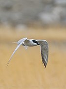
Gull-billed tern (breeding only)
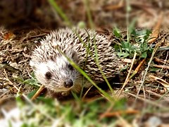
White-breasted hedgehog

Apynian brown bat - an endemic species
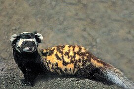
Marbled polecat

Aryanan lynx (subspecies of the Ulethan lynx)

South Ulethan chamois

Aryanan ribber newt
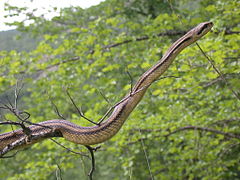
Four-lined ratsnake

Green whip snake

Tree bumblebee

Yellow swallowtail butterfly - a national animal of Qennes
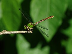
Green snaketail dragonfly - a national animal of Qennes

.jpeg)


.jpg)
_(44745463650).jpg)
.jpg)
_(34149541540).jpg)
.jpg)


_(caught_by_Jean_NICOLAS)_(43565751914).jpg)
.jpg)


Protection
There are a total of X[2] protected areas in Qennes. There are 6 protection categories for areas and 4 for the protection of members of the Qennesan flora & fauna. They are:
- Protection classes for areas, highest level of protection to lowest:
- Geopark - A large unified protected area that advances the protection and use of geological heritage in a sustainable way, and promotes the economic well-being of the people who live there. Example: Geopark "Lipămontală - Lavand" (Shared with Antharia)∈⊾
- Zona Asțîra ḑe Proteḑat (ZAP) - A zone of strict protection laws. Encompases a natural habitat of animals, plants and natural features that are rare or valuable. Example: TBD
- Park Național Proteḑat (PNP) - National park network of areas with special features worthy of protection. Unlike national parks in most other countries, in Qennes they can be much smaller. Example: PNP "Feră Selandină"∈⊾
- Zonă Pitoreaskă și a Vieții Sălbatike (ZPVS) - A zone of natural beauty and/or wildlife with special protection laws. Example: "Meandre ḑe Erez"∈⊾
- Zonă Istorikală (ZI) - A zone of historic importance, usually encompassing a district within a locality. Example: Forț ḑe Erez (Erez Fortress)
- Monumenț Istorikal (MI) - A single or group of objects or structures of historical importance. They can be located within other types of protected areas. Example: Ekilița ḑe Sîc̣i Tomas ḑin Artei (Saint Thomas Church in Artei)

- Protection classes for individual flora and fauna species:
- National animal / National plant - Species of symbolic meaning which may or may not be under preservation, but has a national-wide symbolism representing the nation of Qennes. Example: Qennesan lavender (Lavandula cenesis)
- Local or endemic species under the Threatened status - Species originating in Qennes or the Iviran Coast region, that are considered as threatened of extinction. Example: Green Snaketail Dragonfly (Ophiogomphus cecilia)
- Worldwide species under the Threatened status - Worldwide species present in Qennes, that are considered as threatened of extinction. Example: Tonenian Emerald Dragonfly (Somatochlora borisi)
- Species of cultural symbolism - Species of cultural symbolism of the Qennesan regions. Example: Ulethan Green Crab in the region of Klavopoli and Niscavo. (Carcinus maenas)
Politics
Administrative divisions
Provinces
The four provinces of Qennes are the first level of subdivision in the country, however they posses no power of their own. Their role is purely ceremonial, historical, statistical and administrative. They follow the historical borders of these regions.
| Province | Coat of Arms | Capital | Number of municipalities | Land area | Population | Population density | ||
|---|---|---|---|---|---|---|---|---|
| km² | mi² | km² | mi² | |||||
| Erez∈⊾ |  |
Erez | 4
(Arta, Ederez, Erez, Poiu) |
2241 | 865 | 710,046 | 316 | 820 |
| Feredetî∈⊾ | Malvertta | 4
(Este, Kastelnău, Malvertta, Sentares) |
1233 | 476 | 1,364,793 | 1,106 | 2,867 | |
| Lipămontală∈⊾ | Dadaș | 3
(Dadaş, Montăndur, Reța) |
3426 | 1322 | 387,521 | 113 | 293 | |
| Tîrdau∈⊾ | Koșteiu | 4
(Amnaş, Artei, Kănpitau, Koşteiu) |
3093 | 1194 | 544,020 | 175 | 455 | |
Municipalities
The municipalities of Qennes present the second level of administrative subdivisions, and the highest of local governance. As opposed to provinces, municipalities govern their designated area and can enact certain local laws. A municipality has a municipal president, representing the Peasantry and elected by the people; and a municipal noble, who presents a mostly ceremonial figure, and represents the municipality in the Nobility. A municipality can have one or more communes with the city or town title, but only one of the having the role of the municipal center. The only exception is Malvertta whose municipality as a whole is a city (Metropol) and as such is divided into suburbs.
There are 15 municipalities, each province having 4 of them, with the exception of Lipămontală which has 3.
| Municipality | Coat of Arms | Adm. centre | Number of cities | Land area | Population | Population density | ||
|---|---|---|---|---|---|---|---|---|
| km² | mi² | inhab./km² | inhab./mi² | |||||
| Amnaş∈⊾ |  |
Amnaş | 2
(Amnaș, Fontanași) |
505 | 195 | 60,127 | 119 | 308 |
| Ăndur)∈⊾ |  |
Montăndur | 3
(Auran, Montăndur, Obreșt) |
1121 | 432 | 103,430 | 92 | 239 |
| Reḑionu Kapital ḑe Arta∈⊾ |  |
Arta | 1
(Arta) |
125 | 48 | 76,687 | 613 | 1,597 |
| Dadaş - Kopiță∈⊾ |  |
Dadaş | 3
(Dadaş, Lîulină, Toronei) |
1297 | 500 | 178,504 | 137 | 357 |
| Ederez∈⊾ |  |
Ederez | 2
(Ederez, Teparkaş) |
609 | 235 | 52,630 | 86 | 223 |
| Erez∈⊾ | |
Erez | 3
(Absarai, Erez, Porterez) |
293 | 113 | 370,061 | 1,263 | 3,274 |
| Galină∈⊾ |  |
Artei | 4
(Artei, Daroț, Galadeș, Ivaneș) |
1135 | 438 | 139,820 | 123 | 319 |
| Kaneș - Montă∈⊾ |  |
Reța | 3
(Baneșt, Reța, Sîc̣u Petru) |
1007 | 389 | 105,587 | 104 | 271 |
| Kaneș al Kaț∈⊾ |  |
Poiu | 4
(Ekrîn, Palaț, Poiu, Troaș Nău) |
1070 | 413 | 210,668 | 196 | 510 |
| Kol∈⊾ |  |
Este | 4
(Este, Kolkastem, Masetna, Venneșe) |
165 | 63 | 364,632 | 2,209 | 5,787 |
| Koşteiu∈⊾ |  |
Koşteiu | 4
(Amaraștii, Boksa, Koșteiu, Săntă Maria) |
452 | 174 | 257,565 | 569 | 1,480 |
| Laş∈⊾ |  |
Kastelnău | 3
(Kastelnău, Omnikă, Beņeș) |
355 | 137 | 120,872 | 340 | 882 |
| Malvertta∈⊾ |  |
Malvertta | 5
(Malvertta, Țoși, Țoțoș, Meteļin, Manată) |
104 | 40 | 632,131 | 6,078 | 15,803 |
| Prață∈⊾ |  |
Kănpitau | 2
(Kănpitau, Ogașu Galbină) |
1000 | 386 | 86,508 | 86 | 224 |
| Res∈⊾ |  |
Sentares | 3
(Klavopoli, Sentares, Setnes) |
605 | 234 | 247,158 | 407 | 1,056 |
Economy
 | |||||||||||||||||||||
|---|---|---|---|---|---|---|---|---|---|---|---|---|---|---|---|---|---|---|---|---|---|
| Economy of Qennes | |||||||||||||||||||||
| Mixed economy | |||||||||||||||||||||
| Currency | Qennesan Lîu (QNL) | ||||||||||||||||||||
| Monetary authority | National Monetary Fund of Qennes (FNNK) | ||||||||||||||||||||
| GDP (PPP) | 2022 estimate | ||||||||||||||||||||
| • Total | |||||||||||||||||||||
| • Per capita | |||||||||||||||||||||
| HDI (2022) | very high | ||||||||||||||||||||
| Principal exports | Cosmetics, naval supplies, electricity equipment, medical supplies, agricultural products, chemical products... | ||||||||||||||||||||
| Principal imports | Vehicles, gas & petroleum, electricity, packaged medicaments, ores, textile products, electronics... | ||||||||||||||||||||
Industries and sectors | |||||||||||||||||||||
| |||||||||||||||||||||
| Exports Main export partners Imports Main import partners | Template:Lorantis | ||||||||||||||||||||
| Wealth inequality index | medium | ||||||||||||||||||||
.jpeg)
Qennes has a developed market economy and is one of the most economically developed countries in Uletha. According to the national economic data, the national GDP (PPP) is estimated at 178 billion USD, while the per capita rates stood at just below 60 thousand USD, representing one of the highest GDP per capita rates in the Iviran Coast region, the continent of Uletha and also the whole world. Qennes is also characterized with its incredibly high wealth inequality index standing at around the rate of 39.
Qennes' history marked a lumpy economic growth rate. It has been sealed primarily by trading and shipbuilding in Malvertta and most coastal towns, wine production in the south, while the interior was dominated by agriculture, pasture and most notably flower production with lavenders being the most iconic crop to be grown in Qennes, used as a symbol for the entire nation. Navenna played an important role in developing Malvertta by introducing more skilled merchants and shipbuilders, as well as developing the country's iconic canal systems in Malvertta as well.
The once prominent trading node and hub in Malvertta lost importance over time with power shifting elsewhere. Shipbuilding and the production of naval supplies increased in importance together with the worldwide industrial boom. Lavender was used in the newly created modern cosmetics industry for the royal families. Transitioning into the 19th and 20th centuries, Qennes got its first railway connection towards Niscavo and Valessa. A few years later, the whole country was connected with railways. Shipbuilding reached an all-time high in terms of production with the rise of the modern container ships.
Nowadays, Qennes has a very diverse economic layout with branches like tourism, business, banking and services dominating the economic outline map, alongside the historically present shipbuilding, cosmetics and agricultural sectors. Qennes is one of the world's most favorable summer tourist destinations, reaching 19.5 million tourists in 2021. The coastal area known as the Qennesan Riviera accounts for more than 70% of the tourist attractions, with numerous beaches and resorts along the coast and picteresque towns including Malvertta, Este, Mastena, Klavopoli featuring touristy old towns. Malvertta is also the national recreative and leisural centre known for its nightlife and a high number of entertainment options including numerous concerts, festials, fairs, amongst others.
The finance and commerce sector is characterized by the favorable tax system as well as banking anonymity. Although not one of the major tax havens, Qennes is often categorized as one. Qennes has a large welfare system covering virtually all sectors of the economy and every people group within Qennes. Through its programmes and services it provides a large amount of aid for business starting, agricultural development, immigrants, tourism workers, small businesses and freelancers, amongst others.
Other sectors Qennes is prominent in include: technology, cosmetics, manufacturing, shipbuilding, naval manufacturing, agriculture, energy, medicine, etc. Qennes is home to a wide variety of globally present companies. The most prominent one is Lux SolarPower, specializing in solar power production and equipment with solar power plants throughout the globe. Kastor is another company which emerged on the global market, specializing in home improvement retail, home and DIY tools, home decorations, construction tools, etc. UletaFood is a large food and beverage processing company with a large presence on the Ulethan market, while ICQ is one of the leaders in the chemicals production market, with both companies having subsidiaries in countries like the CCA. Within the local market, some of the dominant companies include Modio, the largest supermarket chain in the country, Aria Foods, ExSpedition, Exomar, Nutrilon, Renat, Tip, BKP, Medela, AgroMart, etc.
Services & industry
Energy
Tourism
Qennesan Riviera
Transport & infrastructure
Education
Demographics

Urbanization
Qennes is a heavily urbanized country with xx% of its population living in urban areas. Qennes has 35 towns, 5 cities, 4 metropolitan suburbs, one metropolitan city and one capital city. Qennesan cities and towns vary from urban metropolises to little townships. A trend is noticeable in the south where cities are experiencing massive population increases mostly from immigration, whereas cities from the central and northern areas have a generally negative growth nature. The first locality to be granted the title of a town is Porterez in 762 AD (at the time named Erulgi), while the latest one is Setnes getting the title in 2021. The only town whos title was revoked is Medalona in 2015.
| Co. | Key |
|---|---|
| National capital | |
| Metropolitan city[3] | |
| Metropolitan suburb town[4] | |
| City[5] | |
| Towns (Municipal centers) |
| # | City | Cd. | Province | City population | Commune pop. | Growth (over 365 days) |
|---|---|---|---|---|---|---|
| 1 | MA | Feredetî | 257,681 (632,131)[6] | 632,131 | +2.07% | |
| 2 | EZ | Erez | 242,618 | 275,748 | -0.42% | |
| 3 | EE | Feredetî | 154,338 | 225,573 | +3.8% | |
| 4 | KȘ | Tîrdau | 127,168 | 165,722 | +0.42% | |
| 5 | ȚȚ | Feredetî | 109,118 | - | +3.15% | |
| 6 | ȚȘ | Feredetî | 98,091 | - | +4.51% | |
| 7 | DD | Lipămontală | 91,164 | 121,543 | +0.43% | |
| 8 | SE | Feredetî | 87,159 | 146,733 | +0.66% | |
| 9 | MT | Feredetî | 86,168 | - | +3.89% | |
| 10 | MN | Feredetî | 81,073 | - | +12.72% | |
| 11 | A | Erez | 69,552 | 76,687 | +2.7% | |
| 12 | PO | Erez | 52,168 | 86,186 | +0.55% | |
| 13 | AE | Tîrdau | 47,591 | 64,169 | -0.48% | |
| 14 | RE | Lipămontală | 42,119 | 62,558 | -0.21% | |
| 15 | KS | Feredetî | 32,005 | 53,762 | +0.62% | |
| 16 | KL | Feredetî | 27,151 | 63,183 | +0.5% | |
| 17 | KP | Tîrdau | 26,967 | 59,730 | -0.07% | |
| 18 | VE | Feredetî | 25,093 | 59,555 | +8.17% | |
| 19 | MĂ | Lipămontală | 22,889 | 46,082 | +0.3% | |
| 20 | TO | Lipămontală | 19,532 | 29,305 | -0.61% | |
| 21 | KK | Feredetî | 17,191 | 39,306 | +0.97% | |
| 22 | AM | Tîrdau | 17,069 | 32,752 | -0.2% | |
| 23 | PE | Erez | 15,984 | 44,174 | +1.62% | |
| 24 | EK | Erez | 15,661 | 43,326 | +0.62% | |
| 25 | ED | Erez | 15,294 | 28,580 | -0.45% | |
| 26 | MS | Feredetî | 14,864 | 40,198 | +1.13% | |
| 27 | SM | Tîrdau | 14,583 | 34,772 | +0.56% | |
| 28 | AȘ | Tîrdau | 13,198 | 32,618 | -0.45% | |
| 29 | IV | Tîrdau | 13,002 | 27,466 | -2.21% | |
| 30 | AB | Erez | 12,648 | 50,139 | +2.1% | |
| 31 | BO | Tîrdau | 12,222 | 24,319 | -1.02% | |
| 32 | DA | Tîrdau | 11,968 | 25,708 | -3.17% | |
| 33 | OB | Lipămontală | 11,556 | 27,229 | -0.79% | |
| 34 | PA | Erez | 11,495 | 41,591 | +0.41% | |
| 35 | TE | Erez | 11,092 | 24,050 | -1.81% | |
| 36 | AU | Lipămontală | 10,246 | 30,119 | -1.87% | |
| 37 | OM | Feredetî | 9,618 | 36,619 | +3.55% | |
| 38 | GA | Tîrdau | 9,215 | 22,477 | -3.98% | |
| 39 | TN | Erez | 9,000 | 39,565 | +0.21% | |
| 40 | FO | Tîrdau | 8,671 | 27,509 | -0.52% | |
| 41 | BE | Feredetî | 7,981 | 30,491 | +0.75% | |
| 42 | BA | Lipămontală | 7,664 | 19,011 | -7.71% | |
| 43 | SP | Lipămontală | 7,512 | 24,018 | -2.81% | |
| 44 | LL | Lipămontală | 7,291 | 27,656 | -0.57% | |
| 45 | OG | Tîrdau | 6,816 | 26,778 | -5.71% | |
| 46 | ST | Feredetî | 5,198 | 37,242 | +2.81% |
Ethnic & national composition

.jpg)
Languages
Religion
Migration
Culture
Heritage
Cuisine
Festivals & events
Media
Art
Literature
Music & dance
Architecture
Museums, theaters & others
National symbols
Sports
See also
References
- ↑ https://wiki.opengeofiction.net/wiki/index.php/Talk:OGF:Plate_tectonics
- ↑ So far, there are 11 mapped protected areas in Qennes
- ↑ By Qennesan law, a metropolitan city is any city which has a national and regional influence over various aspects, and is large enough to include surrounding towns as part of itself. A metropolitan city is divided upon suburbs.
- ↑ Act as independent cities within a metropolitan city area.
- ↑ By Qennesan law, a city is any locality with national influence and a significant population. Provincial capitals are also cities by default.
- ↑ By the Qennesan law, Malvertta as a metropolitan city includes the suburbs of its municipality when calculating city population. Those are indicated in italics in this list. The given population is for the suburb of Malvertta, with the total population given in the brackets.