User:Mstr/Sandbox: Difference between revisions
mNo edit summary |
|||
| Line 16: | Line 16: | ||
Other bordering countries are (in clockwise order) [[Darcodia]], [[Keira]], [[Älved]], [[Kåra ]], [[Glaster]], [[Wyster]], [[Älgert]], [[Mergania]], [[Eshein]], [[Nelavia]], [[Sãikyel]], [[x]], [[x]], [[x]], [[x]], [[Reeland]], [[Ispelia]] and [[Vartasimalia]]. The sea is connected via 3 straits (Strait of ?, [[Strait of Madrin]], [[Suidern Strait]]) to the [[Eastern Ocean]]. | Other bordering countries are (in clockwise order) [[Darcodia]], [[Keira]], [[Älved]], [[Kåra ]], [[Glaster]], [[Wyster]], [[Älgert]], [[Mergania]], [[Eshein]], [[Nelavia]], [[Sãikyel]], [[x]], [[x]], [[x]], [[x]], [[Reeland]], [[Ispelia]] and [[Vartasimalia]]. The sea is connected via 3 straits (Strait of ?, [[Strait of Madrin]], [[Suidern Strait]]) to the [[Eastern Ocean]]. | ||
<div style="clear:both;"></div> | <div style="clear:both;"></div><!-- ############################################################################################################## --> | ||
==Eastern Uletha== | ==Eastern Uletha== | ||
{{Infobox country | {{Infobox country | ||
| Line 34: | Line 34: | ||
From a political and economic point of view, the formation of the [[User:Mstr/Sandbox#x|Eastern Ulethan Organisation of Independent Allies]] had a very high impact. | From a political and economic point of view, the formation of the [[User:Mstr/Sandbox#x|Eastern Ulethan Organisation of Independent Allies]] had a very high impact. | ||
<div style="clear:both;"></div> | <div style="clear:both;"></div><!-- ############################################################################################################## --> | ||
==Gulf of Volta== | ==Gulf of Volta== | ||
{{Infobox country | {{Infobox country | ||
| Line 42: | Line 42: | ||
|common_name = Gulf of Volta | |common_name = Gulf of Volta | ||
}} | }} | ||
The '''Gulf of Volta''' ([[Eshen]]: ''Galf av Wo̊ltta''; [[User:Mstr/Sandbox#Mergan language|Mergan]]: ''Golf von Volta'') is an oceanic basin that is a southwestward extension of the [[Scythian Sea]]. It is surrounded entirely by parts of the [[Uletha|Ulethan continent]] and serves as an interior, marginal sea off the [[Ardentic Ocean]]. The bordering countries are (in clockwise order) [[Eshein]], [[Viljanni]], [[Mergania]], [[Helvetiany]], [[UL012]], [[UL013]], [[Anisora]], [[Palaseskia]], [[Kanea]], [[UL015f]], [[UL015e]], [[Supernia]] and [[Nelavia]]. The bay is connected via the [[Strait of Madrin]], [[Strait of Owneheym]] and the [[Southern Strait ( | The '''Gulf of Volta''' ([[Eshen]]: ''Galf av Wo̊ltta''; [[User:Mstr/Sandbox#Mergan language|Mergan]]: ''Golf von Volta'') is an oceanic basin that is a southwestward extension of the [[Scythian Sea]]. It is surrounded entirely by parts of the [[Uletha|Ulethan continent]] and serves as an interior, marginal sea off the [[Ardentic Ocean]]. The bordering countries are (in clockwise order) [[Eshein]], [[Viljanni]], [[Mergania]], [[Helvetiany]], [[UL012]], [[UL013]], [[Anisora]], [[Palaseskia]], [[Kanea]], [[UL015f]], [[UL015e]], [[Supernia]] and [[Nelavia]]. The bay is connected via the [[Strait of Madrin]], [[Strait of Owneheym]] and the [[Southern Strait (Mergania)|Southern Strait]] to the [[Darcodian Sea]]. | ||
Major ports include the [[Port of Brugham]] in the northwest, the [[Eym|Port of Eym]]. | Major ports include the [[Port of Brugham]] in the northwest, the [[Eym|Port of Eym]]. | ||
===Etymology=== | ===Etymology=== | ||
Its [[Ingerish]] name is derived from the island [[Volta]]. In [[Eshen]], the name of Volta is | Its [[Ingerish]] name is derived from the island [[Volta]]. In [[Eshen]], the name of Volta is "Wo̊ltta" therefore the name of the gulf in Eshen is "Galf av Wo̊ltta", Gulf of Volta. | ||
<div style="clear:both;"></div> | <div style="clear:both;"></div><!-- ############################################################################################################## --> | ||
==Map of natural ressources== | ==Map of natural ressources== | ||
| Line 169: | Line 169: | ||
| marker = -5.1029,29.6099 ~Uranium ~ ~ | | marker = -5.1029,29.6099 ~Uranium ~ ~ | ||
}} | }} | ||
<div style="clear:both;"></div><!-- ############################################################################################################## --> | |||
==Kalmish language== | |||
{{Infobox lang | |||
| boxwidth = 300px | |||
| familycolor = {{Langfam|UT}} | |||
| headercolor = | |||
| name = Kalmish | |||
| altname = | |||
| nativename = Kalmisch | |||
| pronunciation = /kɑ:lmɪʃ/ | |||
| states = | |||
| region = Originally {{Kalm}}, now worldwide | |||
| ethnicity = | |||
| speakers = 206 million | |||
| speakers2 = | |||
| date = 2001 | |||
| dateprefix = as of | |||
| extinct = | |||
| revived = | |||
| era = | |||
| fam1 = [[Uletarephian]] | |||
| fam2 = [[Gaermanic]] | |||
| fam3 = [[Uletarephian/Gaermanic languages#West Gaermanic languages|West Gaermanic]] | |||
| fam4 = | |||
| fam5 = | |||
| ancestor1 = | |||
| ancestor2 = | |||
| ancestor3 = | |||
| ancestor4 = | |||
| ancestor5 = | |||
| creator = | |||
| created = | |||
| setting = | |||
| posteriori = | |||
| dia1 = | |||
| dia2 = | |||
| dia3 = | |||
| dia4 = | |||
| dia5 = | |||
| dia6 = | |||
| dia7 = | |||
| dia8 = | |||
| dia9 = | |||
| dia10 = | |||
| dia11 = | |||
| dia12 = | |||
| dia13 = | |||
| dia14 = | |||
| dia15 = | |||
| dia16 = | |||
| dia17 = | |||
| dia18 = | |||
| dia19 = | |||
| dia20 = | |||
| stand1 = | |||
| stand2 = | |||
| stand3 = | |||
| stand4 = | |||
| stand5 = | |||
| script = [[Romantian|Romantian script]] ([[Kalmish#Kalmish alphabet|Kalmish alphabet]]) | |||
| sign = | |||
| nation = <!--[[File:AN_Flag.png|28px|border]] [[Assembly of Nations]]<br />-->{{Kalm}}<br />{{Midistland}}<br />{{Älved}} (Mergan)<br />{{Helvetiany}} (Mergan)<br />{{Mergania}} (Mergan)<br>{{Zylanda}} (Sassn) | |||
| minority = {{Garlis}}<br />{{Sathria}}<br />{{Eshein}} (Mergan)<br />{{Mauretia}} (Mergan)<br />{{Reeland}} (Mergan)<br />{{Viljanni}} (Mergan) | |||
| agency = | |||
| code1name = [[List of OGFL codes|OGFL-1]] | |||
| code1value = kl | |||
| code2name = [[List of OGFL codes|OGFL-2]] | |||
| code2value = klm | |||
| code3name = | |||
| code3value = | |||
| code4name = | |||
| code4value = | |||
| code5name = | |||
| code5value = | |||
| image = | |||
| imagesize = | |||
| imagealt = | |||
| imagecaption = | |||
| imageheader = | |||
| map = | |||
| mapsize = | |||
| mapalt = | |||
| mapcaption = | |||
| map2 = | |||
| mapalt2 = | |||
| mapcaption2 = | |||
| footnotes = | |||
}}'''Kalmish''' is a [[Uletarephian/Gaermanic languages#West Gaermanic languages|West Gaermanic language]] in the [[Uletarephian/Gaermanic languages|Uletarephian Language Group]] that was first spoken in [[Kalm]] and is now a language spoken everywhere in the world. Prominent variants of Kalmish are [[Gaerman]], [[Mergan]] and [[Zylandian Language|Sassn in Zylanda]]. | |||
==History and geographic distribution== | |||
* at the beginning of the 12th century: merchants of the [[Sellern dynasty]] and, a few years later, a large amount of emigrants spread Kalmish across [[Central Uletha]] and [[Eastern Uletha]], nowasays it is still present at some of these places, e.g. in [[Midistland]] or represented by the [[Mergan |Mergan language]] in [[Älved]], [[Helvetiany]] and [[Mergania]] | |||
*1470s merchants and adventurers from Kalm settled in [[Zylanda]], nowadays [[Zylandian Language|Sassn]] is based in Kalmish | |||
*Kalmish colonization of [[Teenesccan]] | |||
*emigration to [[Zylanda]] during the [[Nine Year War]] in 1667-1676 | |||
===Kalmish alphabet=== | |||
The modern Kalmish alphabet consists of the twenty-six standard Latinic letters plus four special letters, all are part of the [[Planetary Association for Rationalisation|PAR Unicode]]-letters. | |||
{| | |||
| width="150px" valign="top" | | |||
{| class="wikitable" | |||
! Capital<br>letter | |||
! Small<br>letter | |||
! Pronunciation<br>([[Phonetic Alphabet of Caflin|PAC]]) | |||
|- | |||
|style="background: #8888ff"|'''A''' | |||
|style="background: #8888ff"|'''a''' | |||
|style="background: #8888ff"|/aː/ | |||
|- | |||
|style="background: #ccccff"|'''Ä''' | |||
|style="background: #ccccff"|'''ä''' | |||
|style="background: #ccccff"|/ɛː/ | |||
|- | |||
|'''B''' | |||
|'''b''' | |||
|/beː/ | |||
|- | |||
|'''C''' | |||
|'''c''' | |||
|/t͡seː/ | |||
|- | |||
|'''D''' | |||
|'''d''' | |||
|/deː/ | |||
|- | |||
|style="background: #8888ff"|'''E''' | |||
|style="background: #8888ff"|'''e''' | |||
|style="background: #8888ff"|/eː/ | |||
|- | |||
|'''F''' | |||
|'''f''' | |||
|/ɛf/ | |||
|- | |||
|'''G''' | |||
|'''g''' | |||
|/ɡeː/ | |||
|- | |||
|'''H''' | |||
|'''h''' | |||
|/haː/ | |||
|- | |||
|style="background: #8888ff"|'''I''' | |||
|style="background: #8888ff"|'''i''' | |||
|style="background: #8888ff"|/iː/ | |||
|} | |||
| width="10px" | | |||
| width="150px" valign="top" | | |||
{| class="wikitable" | |||
! Capital<br>letter | |||
! Small<br>letter | |||
! Pronunciation<br>([[Phonetic Alphabet of Caflin|PAC]]) | |||
|- | |||
|'''J''' | |||
|'''j''' | |||
|/jɔt/ | |||
|- | |||
|'''K''' | |||
|'''k''' | |||
|/kaː/ | |||
|- | |||
|'''L''' | |||
|'''l''' | |||
|/ɛl/ | |||
|- | |||
|'''M''' | |||
|'''m''' | |||
|/ɛm/ | |||
|- | |||
|'''N''' | |||
|'''n''' | |||
|/ɛn/ | |||
|- | |||
|style="background: #8888ff"|'''O''' | |||
|style="background: #8888ff"|'''o''' | |||
|style="background: #8888ff"|/oː/ | |||
|- | |||
|style="background: #ccccff"|'''Ö''' | |||
|style="background: #ccccff"|'''ö''' | |||
|style="background: #ccccff"|/øː/ | |||
|- | |||
|'''P''' | |||
|'''p''' | |||
|/peː/ | |||
|- | |||
|'''Q''' | |||
|'''q''' | |||
|/kuː/ | |||
|- | |||
|'''R''' | |||
|'''r''' | |||
|/ɛʁ/ | |||
|} | |||
| width="10px" | | |||
| width="150px" valign="top" | | |||
{| class="wikitable" | |||
! Capital<br>letter | |||
! Small<br>letter | |||
! Pronunciation<br>([[Phonetic Alphabet of Caflin|PAC]]) | |||
|- | |||
|'''S''' | |||
|'''s''' | |||
|/ɛs/ | |||
|- | |||
|'''''' | |||
|'''ß''' | |||
| | |||
|- | |||
|'''T''' | |||
|'''t''' | |||
|/teː/ | |||
|- | |||
|style="background: #8888ff"|'''U''' | |||
|style="background: #8888ff"|'''u''' | |||
|style="background: #8888ff"|/uː/ | |||
|- | |||
|style="background: #ccccff"|'''Ü''' | |||
|style="background: #ccccff"|'''ü''' | |||
|style="background: #ccccff"|/yː/ | |||
|- | |||
|'''V''' | |||
|'''v''' | |||
|/faʊ̯/ | |||
|- | |||
|'''W''' | |||
|'''w''' | |||
|/veː/ | |||
|- | |||
|'''X''' | |||
|'''x''' | |||
|/ɪks/ | |||
|- | |||
|'''Y''' | |||
|'''y''' | |||
|/ˈʏpsilɔn/ | |||
|- | |||
|'''Z''' | |||
|'''z''' | |||
|/t͡sɛt/ | |||
|} | |||
|} | |||
===Naming=== | |||
The continents are named in Kalmish: | |||
*[[Antarephia|Antarefia]] | |||
*[[Archanta|Arkanta]] | |||
*[[Ereva]] | |||
*[[Kartumia]] | |||
*[[Orano]] | |||
*[[Pelanesia|Pelanesien]] | |||
*[[Tarephia|Tarefia]] | |||
*[[Uletha]] | |||
<div style="clear:both;"></div><!-- ############################################################################################################## --> | |||
==Mergan language== | ==Mergan language== | ||
| Line 227: | Line 481: | ||
The Mergan state broadcaster '''Mergan Vision''' provides radio and television broadcasts in Mergan across the globe. | The Mergan state broadcaster '''Mergan Vision''' provides radio and television broadcasts in Mergan across the globe. | ||
<div style="clear:both;"></div> | <div style="clear:both;"></div><!-- ############################################################################################################## --> | ||
==National flag of Mergania== | ==National flag of Mergania== | ||
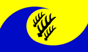
[[File:Mergania_flag.png|180px|thumb|right|The flag of Mergania|link=]]The '''flag of Mergania''' or Mergan flag (Mergan: Merganische Flagge) consists of the two national colors of Mergania (Mergan: Blau-Gold) | [[File:Mergania_flag.png|180px|thumb|right|The flag of Mergania|link=]]The '''flag of Mergania''' or Mergan flag (Mergan: Merganische Flagge) consists of the two national colors of Mergania (Mergan: Blau-Gold) | ||
| Line 239: | Line 494: | ||
Mergania's flag was first adopted as the national flag in 1832, but details have been modified several times until 1921, when the current flag was created. | Mergania's flag was first adopted as the national flag in 1832, but details have been modified several times until 1921, when the current flag was created. | ||
<div style="clear:both;"></div> | <div style="clear:both;"></div><!-- ############################################################################################################## --> | ||
==Scythe of Uletha== | ==Scythe of Uletha== | ||
| Line 253: | Line 508: | ||
The islands are surrounded by the [[Mergania#Darcodian Sea|Darcodian Sea]], the [[Mergania#Gulf of Volta|Gulf of Volta]] and the [[Valian Sea]] of the [[Ardentic Ocean]]. | The islands are surrounded by the [[Mergania#Darcodian Sea|Darcodian Sea]], the [[Mergania#Gulf of Volta|Gulf of Volta]] and the [[Valian Sea]] of the [[Ardentic Ocean]]. | ||
<div style="clear:both;"></div> | <div style="clear:both;"></div><!-- ############################################################################################################## --> | ||
Revision as of 03:16, 30 July 2022
Darcodian Sea
| Darcodian Sea | |
|---|---|
Loading map... |
The Darcodian Sea is a sea in the east of Uletha. Its name derives from the bordering country Darcodia. Other bordering countries are (in clockwise order) Darcodia, Keira, Älved, Kåra , Glaster, Wyster, Älgert, Mergania, Eshein, Nelavia, Sãikyel, x, x, x, x, Reeland, Ispelia and Vartasimalia. The sea is connected via 3 straits (Strait of ?, Strait of Madrin, Suidern Strait) to the Eastern Ocean.
Eastern Uletha
| Eastern Uletha | |
|---|---|
Loading map... |
Eastern Uletha, also known as East Uletha, is the eastern part of the Ulethan continent.
Geographical definition
While the outer geographical boundaries of Uletha are well defined, the boundaries of regions in Uletha are not. A quite common definition is that Midistland and all countries east of it belong to Eastern Uletha. In some cases, countries on the Axian Peninsula (Pasundan-Padjadjaran, Wiwaxia and Ataraxia) and the north do not belong to Eastern Uletha.
Central bodies of water in Eastern Uletha are the Kaspen Sea, the Darcodian Sea, the Gulf of Volta and the Gulf of Preya. Very well known is the Scythe of Uletha, a chain of island nations.
Political and economic definitions
From a political and economic point of view, the formation of the Eastern Ulethan Organisation of Independent Allies had a very high impact.
Gulf of Volta
| Gulf of Volta | |
|---|---|
Loading map... |
The Gulf of Volta (Eshen: Galf av Wo̊ltta; Mergan: Golf von Volta) is an oceanic basin that is a southwestward extension of the Scythian Sea. It is surrounded entirely by parts of the Ulethan continent and serves as an interior, marginal sea off the Ardentic Ocean. The bordering countries are (in clockwise order) Eshein, Viljanni, Mergania, Helvetiany, UL012, UL013, Anisora, Palaseskia, Kanea, UL015f, UL015e, Supernia and Nelavia. The bay is connected via the Strait of Madrin, Strait of Owneheym and the Southern Strait to the Darcodian Sea.
Major ports include the Port of Brugham in the northwest, the Port of Eym.
Etymology
Its Ingerish name is derived from the island Volta. In Eshen, the name of Volta is "Wo̊ltta" therefore the name of the gulf in Eshen is "Galf av Wo̊ltta", Gulf of Volta.
Map of natural ressources
a simple map to collect all natural ressources
- taken from the old wiki...
- could/should be improved by a map-based approach(?)
- new ideas are welcome -> e.g. on discussion page
Loading map...
Kalmish language
| Kalmish | ||||||||||
|---|---|---|---|---|---|---|---|---|---|---|
/kɑ:lmɪʃ/ | ||||||||||
| Estimated number of speakers | 206 million | |||||||||
Writing System | ||||||||||
Norms of linguistic structure | ||||||||||
| ||||||||||
| ||||||||||
| ||||||||||
Kalmish is a West Gaermanic language in the Uletarephian Language Group that was first spoken in Kalm and is now a language spoken everywhere in the world. Prominent variants of Kalmish are Gaerman, Mergan and Sassn in Zylanda.
History and geographic distribution
- at the beginning of the 12th century: merchants of the Sellern dynasty and, a few years later, a large amount of emigrants spread Kalmish across Central Uletha and Eastern Uletha, nowasays it is still present at some of these places, e.g. in Midistland or represented by the Mergan language in Älved, Helvetiany and Mergania
- 1470s merchants and adventurers from Kalm settled in Zylanda, nowadays Sassn is based in Kalmish
- Kalmish colonization of Teenesccan
- emigration to Zylanda during the Nine Year War in 1667-1676
Kalmish alphabet
The modern Kalmish alphabet consists of the twenty-six standard Latinic letters plus four special letters, all are part of the PAR Unicode-letters.
|
|
|
Naming
The continents are named in Kalmish:
Mergan language
| Mergan | ||||||||||
|---|---|---|---|---|---|---|---|---|---|---|
/mergan/ | ||||||||||
| Estimated number of speakers | 60 million | |||||||||
| Regulating body | (regulating body) | |||||||||
Writing System | ||||||||||
Norms of linguistic structure | ||||||||||
| ||||||||||
| ||||||||||
| ||||||||||
Mergan (Mergan: Merganisch, in Kalm sometimes called Ostkalmisch) is the Eastern Ulethan variety of Kalmish, mainly written and spoken in and around Mergania. It is official language in Älved and Helvetiany.
History
This is a rough overview how Kalmish came to Eastern Uletha:
- at the beginning of the 12th century merchants of the Sellern dynasty used the Great Pretanic Trade Route to reach the east
- they brought the Kalmish language and culture to the east of the Ulethan continent and spread it to several regions
- several large migration waves in the 12th and 13th century brought a large amount of emigrants to the east, many of them settled around the Kaspen Sea and Darcodian Sea and strengthen Kalmish influence and culture there
- while the sparely populated islands in the east of the Darcodian Sea provided good prospects for the settlers, Kalmish immigrants in many other regions have been expulsed, they moved further eastwards and finally arrived at the Mergan islands as well
- during the centuries, culture and language developed differently in the East (Mergan) and West(Kalmish), however not independently and only with slight differences due to strong trade relations
- the spread of the written Kalmish language in the 17th and 18th century led to a gradually adjustment of the spoken Mergan language, so Mergan became again (and nowadays Standard Mergan is) similar to Modern Kalmish
Geographic distribution
Mergan is official language in Mergania, Älved and Helvetiany and spoken by minorities in many countries in Eastern Uletha.
Standard Mergan and dialects
Typical Mergan words (contrary to Kalmish):
- Suid - Süd
- Brug - Festung
- Belt - Meerenge
- ...
- ...
- ...
Plaat
Plaat is a Mergan dialect spoken mainly in the coastal regions of Helvetiany.
Mergan Vision
The Mergan state broadcaster Mergan Vision provides radio and television broadcasts in Mergan across the globe.
National flag of Mergania
The flag of Mergania or Mergan flag (Mergan: Merganische Flagge) consists of the two national colors of Mergania (Mergan: Blau-Gold)
arranged in form of a spiral. Gold symoblizes the grain growing in the huge wheatfields while blue stands for the sea surrounding the Mergan islands. The spiral shape can also be interpreted as an allusion to waves of the sea. The flag's center shows three black stag antlers in diagonal direction, each on gold background. The stag antlers stem from the Mähringer Dynasty. Mergania's flag was first adopted as the national flag in 1832, but details have been modified several times until 1921, when the current flag was created.
Scythe of Uletha
| The Scythe of Uletha | |
|---|---|
Loading map... |
The Scythe of Uletha is a chain of island nations encompassing the easternmost point of Uletha. The nations located on the Scythe are, from south-west to east: Mergania, Älgert, Wyster, Helvetiany, Gornodia, UL25b, UL25d, Justinique, Kaarti, UL25g, Østermark.
The islands are surrounded by the Darcodian Sea, the Gulf of Volta and the Valian Sea of the Ardentic Ocean.