|
|
| Line 1: |
Line 1: |
| <div class="toclimit-1">__TOC__</div>
| |
|
| |
| ==EUOIA successor organization==
| |
| *might keep its old name
| |
| *based on feedback from potential members
| |
| *no large tables, no listing of information already given on member pages
| |
| *will be updated to current status
| |
|
| |
| <div style="border: solid 1px #999; background: #f3f3f3; border-radius: 0.2em; box-shadow: 0 3px 3px #ccc; margin-bottom: 1.5em; width: 99%; padding: .5em;">
| |
| {| style="border:0px; margin: .1em; width: 99%;"
| |
| |-
| |
| | style="width: 12em; vertical-align:top;" | [[File:EUOIA_flag.png|150px|Flag of the EUOIA]]
| |
| | <span style="font-size: 150%; line-height: 1.5;">'''Eastern Ulethan Organisation of Independent Allies'''</span><br />
| |
| ''NATIVE NAME'' (NATIVE LANGUAGE)<br /><div style="columns: 5em 1; padding: .5em;">
| |
| '''Capital:''' CAPITAL<br />
| |
| '''Population:''' POPULATION (POPULATIONYEAR)<br />
| |
| '''Motto:''' MOTTO<br />
| |
| '''Anthem:''' ANTHEM</div>
| |
| | style="width: 12em; vertical-align:top;" | [[File:SYMBOL.png|frameless|right|text-top|75px|SYMBOL CAPTION]]
| |
| |-
| |
| |}
| |
| {{clear}}
| |
| <hr />
| |
| {| align="right" style="border:1px solid black; margin:.25em 0 .25em 1em;"
| |
| |-
| |
| | {{#multimaps: | service = OGF | center = 42,135 | width = 500px | height = 350px | zoom = 3 | minzoom = 3 | maxzoom = 5
| |
| | overlays = +Members
| |
| | overlaydef = {
| |
| "Members": {"function": "boundaryRelation", "param": 336623}
| |
| }
| |
| }}
| |
| |-
| |
| |}
| |
| The '''Eastern Ulethan Organisation of Independent Allies''' or '''EUOIA''' ['juoja] is an intergovernmental political, economic, and military alliance between XX independent nations in [[Eastern Uletha]].
| |
| The EUOIA grew from an idea of intergovernmental cooperation to a complex umbrella organisation that manages and promotes many different tiers of involvement.
| |
| Not every member state is involved in or party to each aspect of the organisation.
| |
| {{clear}}
| |
| </div>
| |
|
| |
| ===History===
| |
| Historic places:
| |
| *Silath (Wyster) 51.1584/130.4938
| |
| *Castle Velin (Viljanni)
| |
| *Nortenger (Eshein) 42.9611/129.2591
| |
| *Kalasatama (Eelanti) 55.4991/136.7224
| |
|
| |
|
| |
| Possible names:
| |
| *Eastern Ulethan Organisation of Independent Allies (EUOIA): + well known in the OGF world, - "allies" sounds military
| |
| *Eastern Ulethan Union (EUU): - too close to European Union
| |
| *Associated Nations in Eastern Uletha (ANEU)
| |
| *Eastern Ulethan League (EUL)
| |
| *Organization of Eastern Ulethan Nations/States (OEUN/OEUS)
| |
| *Independent Countries in Eastern Uletha (ICEU)
| |
|
| |
| *Ardentic Ulthea instead of Eastern Uletha?
| |
| *Independent sounds important?
| |
| *States, Nations or countries?
| |
|
| |
| ====Preliminary work and the xxxxx Treaty (1932–1944)====
| |
| ====Treaty of xxxxx (1944–1977)====
| |
| ====xxxxx Treaty (1977–2008)====
| |
| ====Treaty of xxxxx (2008–present)====
| |
|
| |
|
| |
| ====List of summits====
| |
| This is a list of meetings of heads of state or government of EUOIA member states.
| |
| They started in 1944 as two-annual meetings (April/May and October/November) and usually last between 2 and 3 days (Friday afternoon till Sunday evening).
| |
|
| |
| =====1940s=====
| |
| {| class="wikitable mw-collapsible mw-collapsed sortable"
| |
| ! style="width:20px" | #
| |
| ! style="width:50px" | Year
| |
| ! style="width:150px" | Date
| |
| ! style="width:200px" | Host city
| |
| ! style="width:200px" | Host country
| |
| ! class="unsortable"; style="width:500px" | Notes
| |
| |-
| |
| | 1
| |
| | rowspan=2 | 1944
| |
| | May xx-xx
| |
| | tbd
| |
| | tbd
| |
| | Signature of XXXX
| |
| |-
| |
| | 2
| |
| | October xx-xx
| |
| | tbd
| |
| | tbd
| |
| | Signature of XXXX
| |
| |-
| |
| | 3
| |
| | rowspan=2 | 1945
| |
| | May xx-xx
| |
| | tbd
| |
| | tbd
| |
| |
| |
| |-
| |
| | 4
| |
| | October xx-xx
| |
| | tbd
| |
| | tbd
| |
| |
| |
| |-
| |
| | 5
| |
| | rowspan=2 | 1946
| |
| | May xx-xx
| |
| | tbd
| |
| | tbd
| |
| |
| |
| |-
| |
| | 6
| |
| | October xx-xx
| |
| | tbd
| |
| | tbd
| |
| |
| |
| |-
| |
| | 7
| |
| | rowspan=2 | 1947
| |
| | May xx-xx
| |
| | tbd
| |
| | tbd
| |
| |
| |
| |-
| |
| | 8
| |
| | October xx-xx
| |
| | tbd
| |
| | tbd
| |
| |
| |
| |-
| |
| | 9
| |
| | rowspan=2 | 1948
| |
| | May xx-xx
| |
| | tbd
| |
| | tbd
| |
| |
| |
| |-
| |
| | 10
| |
| | October xx-xx
| |
| | tbd
| |
| | tbd
| |
| |
| |
| |-
| |
| | 11
| |
| | rowspan=2 | 1949
| |
| | May xx-xx
| |
| | tbd
| |
| | tbd
| |
| |
| |
| |-
| |
| | 12
| |
| | October xx-xx
| |
| | tbd
| |
| | tbd
| |
| |
| |
| |}
| |
| =====1950s=====
| |
| {| class="wikitable mw-collapsible mw-collapsed sortable"
| |
| ! style="width:20px" | #
| |
| ! style="width:50px" | Year
| |
| ! style="width:150px" | Date
| |
| ! style="width:200px" | Host city
| |
| ! style="width:200px" | Host country
| |
| ! class="unsortable"; style="width:500px" | Notes
| |
| |-
| |
| | 13
| |
| | rowspan=2 | 1950
| |
| | May xx-xx
| |
| | tbd
| |
| | tbd
| |
| |
| |
| |-
| |
| | 14
| |
| | October xx-xx
| |
| | tbd
| |
| | tbd
| |
| |
| |
| |-
| |
| |}
| |
|
| |
| =====1960s=====
| |
| 33
| |
| =====1970s=====
| |
| 53
| |
| =====1980s=====
| |
| 73
| |
| =====1990s=====
| |
| 93
| |
| =====2000s=====
| |
| 113
| |
| =====2010s=====
| |
| {| class="wikitable mw-collapsible mw-collapsed sortable"
| |
| ! style="width:20px" | #
| |
| ! style="width:50px" | Year
| |
| ! style="width:150px" | Date
| |
| ! style="width:200px" | Host city
| |
| ! style="width:200px" | Host country
| |
| ! class="unsortable"; style="width:500px" | Notes
| |
| |-
| |
| | 133
| |
| | rowspan=2 | 2010
| |
| | May xx-xx
| |
| | tbd
| |
| | tbd
| |
| |
| |
| |-
| |
| | 134
| |
| | October xx-xx
| |
| | tbd
| |
| | tbd
| |
| |
| |
| |-
| |
| | 135
| |
| | rowspan=2 | 2011
| |
| | May xx-xx
| |
| | tbd
| |
| | tbd
| |
| |
| |
| |-
| |
| | 136
| |
| | October xx-xx
| |
| | tbd
| |
| | tbd
| |
| |
| |
| |-
| |
| | 137
| |
| | rowspan=2 | 2012
| |
| | May xx-xx
| |
| | tbd
| |
| | tbd
| |
| |
| |
| |-
| |
| | 138
| |
| | October xx-xx
| |
| | tbd
| |
| | tbd
| |
| |
| |
| |-
| |
| | 139
| |
| | rowspan=2 | 2013
| |
| | May xx-xx
| |
| | tbd
| |
| | tbd
| |
| |
| |
| |-
| |
| | 140
| |
| | October xx-xx
| |
| | tbd
| |
| | tbd
| |
| |
| |
| |-
| |
| | 141
| |
| | rowspan=2 | 2014
| |
| | May xx-xx
| |
| | tbd
| |
| | tbd
| |
| |
| |
| |-
| |
| | 142
| |
| | October xx-xx
| |
| | tbd
| |
| | tbd
| |
| |
| |
| |-
| |
| | 143
| |
| | rowspan=2 | 2015
| |
| | May xx-xx
| |
| | tbd
| |
| | tbd
| |
| |
| |
| |-
| |
| | 144
| |
| | October xx-xx
| |
| | tbd
| |
| | tbd
| |
| |
| |
| |-
| |
| | 145
| |
| | rowspan=2 | 2016
| |
| | May xx-xx
| |
| | tbd
| |
| | tbd
| |
| |
| |
| |-
| |
| | 146
| |
| | October xx-xx
| |
| | tbd
| |
| | tbd
| |
| |
| |
| |-
| |
| | 147
| |
| | rowspan=2 | 2017
| |
| | May xx-xx
| |
| | tbd
| |
| | tbd
| |
| |
| |
| |-
| |
| | 148
| |
| | October xx-xx
| |
| | tbd
| |
| | tbd
| |
| |
| |
| |-
| |
| | 149
| |
| | rowspan=2 | 2018
| |
| | May xx-xx
| |
| | tbd
| |
| | tbd
| |
| |
| |
| |-
| |
| | 150
| |
| | October xx-xx
| |
| | tbd
| |
| | tbd
| |
| |
| |
| |-
| |
| | 151
| |
| | rowspan=2 | 2019
| |
| | May xx-xx
| |
| | tbd
| |
| | tbd
| |
| |
| |
| |-
| |
| | 152
| |
| | October xx-xx
| |
| | tbd
| |
| | tbd
| |
| |
| |
| |}
| |
|
| |
| =====2020s=====
| |
| {| class="wikitable mw-collapsible mw-collapsed sortable"
| |
| ! style="width:20px" | #
| |
| ! style="width:50px" | Year
| |
| ! style="width:150px" | Date
| |
| ! style="width:200px" | Host city
| |
| ! style="width:200px" | Host country
| |
| ! class="unsortable"; style="width:500px" | Notes
| |
| |-
| |
| | 153
| |
| | rowspan=2 | 2020
| |
| | May xx-xx
| |
| | tbd
| |
| | tbd
| |
| |
| |
| |-
| |
| | 154
| |
| | October xx-xx
| |
| | tbd
| |
| | tbd
| |
| |
| |
| |-
| |
| | 155
| |
| | rowspan=2 | 2021
| |
| | May xx-xx
| |
| | tbd
| |
| | tbd
| |
| |
| |
| |-
| |
| | 156
| |
| | October xx-xx
| |
| | tbd
| |
| | tbd
| |
| |
| |
| |-
| |
| | 157
| |
| | rowspan=2 | 2022
| |
| | May xx-xx
| |
| | tbd
| |
| | tbd
| |
| |
| |
| |-
| |
| | 158
| |
| | October xx-xx
| |
| | tbd
| |
| | tbd
| |
| |
| |
| |-
| |
| | 159
| |
| | rowspan=2 | 2023
| |
| | May xx-xx
| |
| | tbd
| |
| | tbd
| |
| |
| |
| |-
| |
| | 160
| |
| | October xx-xx
| |
| | tbd
| |
| | tbd
| |
| |
| |
| |-
| |
| | 161
| |
| | rowspan=2 | 2024
| |
| | May xx-xx
| |
| | tbd
| |
| | tbd
| |
| |
| |
| |-
| |
| | 162
| |
| | October xx-xx
| |
| | tbd
| |
| | tbd
| |
| |
| |
| |-
| |
| | 163
| |
| | rowspan=2 | 2025
| |
| | May xx-xx
| |
| | tbd
| |
| | tbd
| |
| |
| |
| |-
| |
| | 164
| |
| | October xx-xx
| |
| | tbd
| |
| | tbd
| |
| |
| |
| |-
| |
| | 165
| |
| | rowspan=2 | 2026
| |
| | May xx-xx
| |
| | tbd
| |
| | tbd
| |
| |
| |
| |-
| |
| | 166
| |
| | October xx-xx
| |
| | tbd
| |
| | tbd
| |
| |
| |
| |-
| |
| | 167
| |
| | rowspan=2 | 2027
| |
| | May xx-xx
| |
| | tbd
| |
| | tbd
| |
| |
| |
| |-
| |
| | 168
| |
| | October xx-xx
| |
| | tbd
| |
| | tbd
| |
| |
| |
| |-
| |
| | 169
| |
| | rowspan=2 | 2028
| |
| | May xx-xx
| |
| | tbd
| |
| | tbd
| |
| |
| |
| |-
| |
| | 170
| |
| | October xx-xx
| |
| | tbd
| |
| | tbd
| |
| |
| |
| |-
| |
| | 171
| |
| | rowspan=2 | 2029
| |
| | May xx-xx
| |
| | tbd
| |
| | tbd
| |
| |
| |
| |-
| |
| | 172
| |
| | October xx-xx
| |
| | tbd
| |
| | tbd
| |
| |
| |
| |}
| |
|
| |
| ===Member states===
| |
| OLD TEXT:
| |
| There are 22 members of the Eastern Ulethan Organisation of Independent Allies. The EUOIA covers a total area of more than 3 million square kilometers across the [[eastern Uletha|eastern portion]] of the [[Uletha]]n continent. The profile of each country varies from smaller countries like [[Viljanni]] to larger ones, such as [[Kojo]]. Every country in the organisation has at least one stretch of coastline, and four of the countries are situated almost entirely on an island. The climate varies from [[Agarderia]] and [[Glaster]]'s colder continental climate in the north to Kojo and [[Belphenia]]'s semi-arid and subtropical regions. All of the countries feature some urbanisation, but the population and density of each member state varies across the spectrum. Viljanni, for example, is among the most densely populated. Although census numbers do not exist for every country, the population within the member states exceeds 420 million. The largest city is [[Pyingshum]], Kojo; Belphenia is the most populated country.
| |
|
| |
| On a political level, each country is different. Most of the member states are republics of some type. [[Eshein]], [[Wiwaxia]] and [[Wyster]] are monarchies. Other varying systems exist, like Belphenia's theocratic guilds. With a few exceptions, most of the countries rank as high or very high on the human development index.
| |
|
| |
|
| |
|
| |
| ===Treaties===
| |
| <!--<div style="margin-left: auto; margin-right: auto; padding: 1.5em; background: #F2F2F2;">
| |
| '''INSTITUTION'''<br>
| |
| ''XXXXX''<br>
| |
| Located in CITY, COUNTRY.<br><br>
| |
| bla bla bla
| |
| </div>-->
| |
| The EUOIA is based on a large number of agreements and treaties.
| |
| A treaty is a binding agreement between EUOIA member countries and sets out EUOIA objectives, rules for EUOIA institutions, how decisions are made and the relationship between the EUOIA and its member countries.
| |
| Actions of the EUOIA itself have to be based on treaties and have to been approved voluntarily and democratically by all invovled EUOIA member countries.
| |
| Treaties are amended to make the EUOIA more efficient and transparent, to prepare for new member countries and to introduce new areas of cooperation.
| |
| Each treaty has to be signed at least by three member nations to come into action.
| |
|
| |
| Besides the Treaty of XXXXX, which have to be ratified and signed by every member and regulates the basic principles and rules of the organization, specialied agreements exist under the umbrella of the organization.
| |
| Under the treaties, EUOIA institutions can adopt legislation, which the member countries then implement.
| |
|
| |
| ====Founding agreements====
| |
| *no military agression
| |
| *acceptance of borders (naval and on land) between member states
| |
| *visa-free travel for citizens of member states (border controls still active)
| |
| *acceptance of economic zones and interests of each member state, participation within national laws possible
| |
| *agreement on treaties and memberships
| |
| {|
| |
| | width="400px" valign="top" |
| |
| <!--
| |
| ###################################### BEGINNING OF TREATY BOX ######################################
| |
| --><div style="border: solid 1px #999; background: #f3f3f3; border-radius: 0.2em; box-shadow: 0 3px 3px #ccc; margin-bottom: 1.5em; width: 350px; padding: .5em;">
| |
| {| style="border: 0px; margin: .1em; width: 99%;"
| |
| |-
| |
| | <div style="text-align: center"><span style="font-size: 110%; line-height: 1.5">'''Treaty of Xxxxxxxx '''</span></div>
| |
| |-
| |
| | Description ... first definition of organization, inly signed by founding members
| |
| |-
| |
| |}
| |
| <hr />
| |
| {| style="border:0px; margin: .1em; width: 99%; font-size: 85%;"
| |
| |-
| |
| | '''Place of signature:'''
| |
| | tbd, [[tbd]]
| |
| |-
| |
| | '''Date:'''
| |
| | May xx, 1944
| |
| |-
| |
| | '''Ratified by:'''
| |
| | [[tbd]], [[tbd]], [[tbd]], [[tbd]]
| |
| |-
| |
| |}</div><!--
| |
| ###################################### END OF TREATY BOX ######################################
| |
| -->
| |
| | width="400px" valign="top" |
| |
| <!--
| |
| ###################################### BEGINNING OF TREATY BOX ######################################
| |
| --><div style="border: solid 1px #999; background: #f3f3f3; border-radius: 0.2em; box-shadow: 0 3px 3px #ccc; margin-bottom: 1.5em; width: 350px; padding: .5em;">
| |
| {| style="border: 0px; margin: .1em; width: 99%;"
| |
| |-
| |
| | <div style="text-align: center"><span style="font-size: 110%; line-height: 1.5">'''Treaty of Xxxxxxxx '''</span></div>
| |
| |-
| |
| | Description ... improved treatment, signed by all member nations
| |
| |-
| |
| |}
| |
| <hr />
| |
| {| style="border:0px; margin: .1em; width: 99%; font-size: 85%;"
| |
| |-
| |
| | '''Place of signature:'''
| |
| | tbd, [[tbd]]
| |
| |-
| |
| | '''Date:'''
| |
| | October xx, 1944
| |
| |-
| |
| | '''Ratified by:'''
| |
| | [[tbd]], [[tbd]], [[tbd]], [[tbd]], [[tbd]] (19xx), [[tbd]] (19xx), [[tbd]] (19xx), [[tbd]] (20xx)
| |
| |-
| |
| |}</div><!--
| |
| ###################################### END OF TREATY BOX ######################################
| |
| -->
| |
| |}
| |
|
| |
| ====Economy & Finance====
| |
| <!--
| |
| ###################################### BEGINNING OF TREATY BOX ######################################
| |
| --><div style="border: solid 1px #999; background: #ffffff; border-radius: 0.2em; box-shadow: 0 3px 3px #ccc; margin-bottom: 1.5em; width: 350px; padding: .5em;">
| |
| {| style="border: 0px; margin: .1em; width: 99%;"
| |
| |-
| |
| TREATY
| |
| * ...
| |
| * ...
| |
| |-
| |
| |}</div><!--
| |
| ###################################### END OF TREATY BOX ######################################
| |
| -->
| |
|
| |
| ====Infrastructure & Communications====
| |
| <!--
| |
| ###################################### BEGINNING OF TREATY BOX ######################################
| |
| --><div style="border: solid 1px #999; background: #ffffff; border-radius: 0.2em; box-shadow: 0 3px 3px #ccc; margin-bottom: 1.5em; width: 350px; padding: .5em;">
| |
| {| style="border: 0px; margin: .1em; width: 99%;"
| |
| |-
| |
| EU Transportation Normalization Act
| |
| * normalization of means of transport
| |
| * ...
| |
| |-
| |
| |}</div><!--
| |
| ###################################### END OF TREATY BOX ######################################
| |
| -->
| |
|
| |
| ====Health, Technology & Research====
| |
| <!--
| |
| ###################################### BEGINNING OF TREATY BOX ######################################
| |
| --><div style="border: solid 1px #999; background: #ffffff; border-radius: 0.2em; box-shadow: 0 3px 3px #ccc; margin-bottom: 1.5em; width: 350px; padding: .5em;">
| |
| {| style="border: 0px; margin: .1em; width: 99%;"
| |
| |-
| |
| TREATY
| |
| * ...
| |
| * ...
| |
| |-
| |
| |}</div><!--
| |
| ###################################### END OF TREATY BOX ######################################
| |
| -->
| |
|
| |
| ====Public Safety & International Security====
| |
| <!--
| |
| ###################################### BEGINNING OF TREATY BOX ######################################
| |
| --><div style="border: solid 1px #999; background: #ffffff; border-radius: 0.2em; box-shadow: 0 3px 3px #ccc; margin-bottom: 1.5em; width: 350px; padding: .5em;">
| |
| {| style="border: 0px; margin: .1em; width: 99%;"
| |
| |-
| |
| EU Nuclear-Weapon-Free Zone
| |
| * establishment and enforcement of a nuclear weapon free zone in Eastern Uletha
| |
| * ...
| |
| |-
| |
| |}</div><!--
| |
| ###################################### END OF TREATY BOX ######################################
| |
| -->
| |
|
| |
| ====Culture, Education & Social issues====
| |
| <!--
| |
| ###################################### BEGINNING OF TREATY BOX ######################################
| |
| --><div style="border: solid 1px #999; background: #f3f3f3; border-radius: 0.2em; box-shadow: 0 3px 3px #ccc; margin-bottom: 1.5em; width: 350px; padding: .5em;">
| |
| {| style="border: 0px; margin: .1em; width: 99%;"
| |
| |-
| |
| | <div style="text-align: center"><span style="font-size: 110%; line-height: 1.5">'''Global Education Act'''</span></div>
| |
| |-
| |
| |
| |
| The Global Education Act enables the free and easy exchange of students.
| |
| It sets up school exchanges and student exchange programs.
| |
| *exchange with other countries outside the organization under the same conditions
| |
| |-
| |
| |}
| |
| <hr />
| |
| {| style="border:0px; margin: .1em; width: 99%; font-size: 85%;"
| |
| |-
| |
| | '''Place of signature:'''
| |
| | tbd, [[tbd]]
| |
| |-
| |
| | '''Date:'''
| |
| | October 27, 1968
| |
| |-
| |
| | '''Ratified by:'''
| |
| | [[tbd]], [[tbd]], [[tbd]], [[Mergany]], [[tbd]], [[Viljanni]], [[tbd]] (2005)
| |
| |-
| |
| |}</div><!--
| |
| ###################################### END OF TREATY BOX ######################################
| |
| -->
| |
|
| |
| ====Climate & Natural Resources====
| |
| <!--
| |
| ###################################### BEGINNING OF TREATY BOX ######################################
| |
| --><div style="border: solid 1px #999; background: #ffffff; border-radius: 0.2em; box-shadow: 0 3px 3px #ccc; margin-bottom: 1.5em; width: 350px; padding: .5em;">
| |
| {| style="border: 0px; margin: .1em; width: 99%;"
| |
| |-
| |
| TREATY
| |
| * ...
| |
| * ...
| |
| |-
| |
| |}</div><!--
| |
| ###################################### END OF TREATY BOX ######################################
| |
| -->
| |
|
| |
| ====TEMPLATE====
| |
| {|
| |
| | width="400px" valign="top" |
| |
| <!--
| |
| ###################################### BEGINNING OF TREATY BOX ######################################
| |
| --><div style="border: solid 1px #999; background: #f3f3f3; border-radius: 0.2em; box-shadow: 0 3px 3px #ccc; margin-bottom: 1.5em; width: 350px; padding: .5em;">
| |
| {| style="border: 0px; margin: .1em; width: 99%;"
| |
| |-
| |
| | <div style="text-align: center"><span style="font-size: 110%; line-height: 1.5">'''Treaty of Xxxxxxxx '''</span></div>
| |
| |-
| |
| | Description ...
| |
| |-
| |
| |}
| |
| <hr />
| |
| {| style="border:0px; margin: .1em; width: 99%; font-size: 85%;"
| |
| |-
| |
| | '''Place of signature:'''
| |
| | tbd, [[tbd]]
| |
| |-
| |
| | '''Date:'''
| |
| | May 15, 1942
| |
| |-
| |
| | '''Ratified by:'''
| |
| | [[Mergania]], [[Viljanni]] (1965)
| |
| |-
| |
| |}</div><!--
| |
| ###################################### END OF TREATY BOX ######################################
| |
| -->
| |
| | width="400px" valign="top" |
| |
| <!--
| |
| ###################################### BEGINNING OF TREATY BOX ######################################
| |
| --><div style="border: solid 1px #999; background: #f3f3f3; border-radius: 0.2em; box-shadow: 0 3px 3px #ccc; margin-bottom: 1.5em; width: 350px; padding: .5em;">
| |
| {| style="border: 0px; margin: .1em; width: 99%;"
| |
| |-
| |
| | <div style="text-align: center"><span style="font-size: 110%; line-height: 1.5">'''Xxxxx Agreement '''</span></div>
| |
| |-
| |
| | Description ...
| |
| |-
| |
| |}
| |
| <hr />
| |
| {| style="border:0px; margin: .1em; width: 99%; font-size: 85%;"
| |
| |-
| |
| | '''Place of signature:'''
| |
| | tbd, [[tbd]]
| |
| |-
| |
| | '''Date:'''
| |
| | May 15, 1942
| |
| |-
| |
| | '''Ratified by:'''
| |
| | [[tbd]], [[tbd]] (1965), [[tbd]] (2005)
| |
| |-
| |
| |}</div><!--
| |
| ###################################### END OF TREATY BOX ######################################
| |
| -->
| |
| | width="400px" valign="top" |
| |
| <!--
| |
| ###################################### BEGINNING OF TREATY BOX ######################################
| |
| --><div style="border: solid 1px #999; background: #ffffff; border-radius: 0.2em; box-shadow: 0 3px 3px #ccc; margin-bottom: 1.5em; width: 350px; padding: .5em;">
| |
| {| style="border: 0px; margin: .1em; width: 99%;"
| |
| |-
| |
| TREATY
| |
| * ...
| |
| * ...
| |
| |-
| |
| |}</div><!--
| |
| ###################################### END OF TREATY BOX ######################################
| |
| -->
| |
| |}
| |
|
| |
| ===Politics===
| |
| ====Legal system and justice====
| |
| ====Foreign relations====
| |
| The EUOIA has a system of common representation available to all member states in select countries.
| |
| These facilities are staffed by EUOIA citizens, and the ambassador is sent by one of the participating states.
| |
| The common representation allows for a cost-saving measure, given that many EUOIA members are smaller countries and the geographic isolation of eastern Uletha.
| |
| Not all countries participate in the common representation system.
| |
| Even among EUOIA members that do participate, individual countries may elect send their own, separate diplomatic delegation.
| |
|
| |
| Some of the common representations abroad are:
| |
| *{{Way|4606881|EUOIAn embassy}} in [[Whangiora]], {{Aorangëa}}
| |
| *{{Node|48605485|EUOIAn embassy}} in [[Motul]], {{Balam-Utz}}
| |
| *{{Relation|153501|EUOIAn embassy}} in [[Iola]], {{Mauretia}}
| |
| *{{Way|2876248|EUOIAn embassy}} in [[Dunwic]], {{Myrcia}}
| |
| *{{Way|10817592|EUOIAn embassy}} in [[Corrostance]], {{Ohemia}}
| |
| *{{Way|16023441|EUOIAn liaison office}} in [[Vang Ngat]], {{Kuehong}}
| |
|
| |
| ===Economy===
| |
|
| |
|
| |
|
| |
| ====Societas Ulethan====
| |
| A '''Societas Ulethan''' (SU) is a public company registered in accordance with the corporate law of the Eastern Ulethan Economic Community (EUEC), introduced in 1992.
| |
| Such a company may more easily transfer to companies in other member states.
| |
| However, national law continues to supplement the basic rules in the regulation on formation and mergers.
| |
| SUs usually use a [[Generic Top Level Domains|.su top-level-domain]]. One of the prominent examples of a SU is the [[Aerotheon Group]].
| |
|
| |
| ===Organizations===
| |
| <div style="margin-left: auto; margin-right: auto; padding: 1.5em; background: #F2F2F2; overflow: auto">
| |
| <div style="float: right">
| |
| {{#multimaps:
| |
| | zoom = 16
| |
| | height = 300px
| |
| | width = 300px
| |
| | center = 47.14373,131.36714
| |
| }}
| |
| </div>
| |
| '''{{node|33640231|OFFICE}}'''<br>
| |
| ''Economic Forum''<br>
| |
| Located in [[Freistat]], {{Mergania}}.<br><br>
| |
| The '''Economic Forum''' is responsible for the ''short distances'' between governments and industrial partners of the member states.
| |
| </div>
| |
| <br>
| |
|
| |
|
| |
|
| |
| ===See also===
| |
| *[[Antarephian Coalition]]
| |
| *[[Assembly of Nations]]
| |
| *[[Association of South Ulethan Nations]]
| |
| *[[Egalian Union]]
| |
| *[[Tarephia Cooperation Council]]
| |
|
| |
| ==Assembly of Nations Office for the Coordination of Humanitarian Affairs and Emergency Relief==
| |
| The '''Assembly of Nations Office for the Coordination of Humanitarian Affairs and Emergency Relief''' (OHAER) is a [[Assembly of Nations]] (AN) body formed in February 1986 by an assembly resolution.
| |
| The resolution was designed to strengthen the AN's response to complex emergencies and natural disasters.
| |
| Earlier endeavors of the AN in such difficult tasks of fast and non-bureaucratic aid often suffer from misorder and unclear task sharing.
| |
| <div style="clear:both;"></div><!-- ############################################################################################################## -->
| |
|
| |
| ==Darcodian Sea==
| |
| {{Infobox country | | {{Infobox country |
| |coords_zoom = 4 | | |coords_zoom = 5<!-- The zoom coords /#map=THIS/xx.xx/xx.xx?layers=x --> |
| |coords_lat = 46.0 | | |coords_lat = 28.194<!-- The y coords /#map=x/THIS/xx.xx?layers=x --> |
| |coords_long = 122.0 | | |coords_long = 159.539<!-- The x coords /#map=x/xx.xx/THIS?layers=x --> |
| |common_name = Darcodian Sea | | |coords_layer = B<!-- The zoom coords /#map=c/xx.xx/xx.xx?layers=THIS (This parameter is entirely optional) --> |
| | |common_name = Kuehong<!-- The name of the country as it's commonly known (e.g Exampleland) --> |
| | |native_name = 家乡<br>Quê Hương<!-- The native name of the country (e.g Éxempelterre) --> |
| | |conventional_long_name = 共和联邦家乡 <br> Cộng hòa liên bang Quê Hương<!-- The conventional long name of the country (e.g Democratic Republic of Exampleland) --> |
| | |image_flag = Flag of Kuehong.png<!-- The country's flag (e.g Exampleland_Flag.png) --> |
| | |alt_flag = <!-- The alt text to go with the flag (e.g Official Flag of Exampleland) --> |
| | |image_coat = Kue Hong COA.png |
| | |alt_coat = <!-- The alt text to go with the flag (e.g Official Coat of arms of Exampleland) --> |
| | |national_motto = <!-- The motto of the country (e.g Draco Dormiens Nunquam Titillandus) --> |
| | |english_motto = <!-- The English translation of the motto, if necessary (e.g In Union and Liberty) --> |
| | |national_anthem = Bài Hát Quê Hương Tôi <br><small> Song of my homeland</small><!-- The national anthem of the country (e.g Song of the Examplese) --> |
| | |image_map = <!-- Image of a map showing the location of the country (e.g Exampleland_Location_Map.png) --> |
| | |alt_map = <!-- The alt text to go with the map (e.g Location of Exampleland shown in Examplia) --> |
| | |map_caption = <!-- The caption shown below the map (e.g Location of Exampleland (blue) shown in Examplia (green)) --> |
| | |capital = [[Bakdep]]<!-- The capital city (e.g Exampletown) --> |
| | |largest_city = Namthinhvuong<!-- The largest city; set this to "capital" without the quotes if it's the same as the capital city (e.g Exampleford) --> |
| | |official_languages = Kuehongese <br> Babelic <!-- The official languages of the country (e.g Examplese, English) --> |
| | |national_languages = Kuehongese<!-- Nation-wide recognised languages (e.g Catalan, Afrikaans) --> |
| | |regional_languages = Neeg |
| | |ethnic_groups = Kue (67.7%) <br> Bai (18.5%) <br> Other Archantans (4.7%) <br> Neeg (3.6%) <br>Other (5.5%)<!-- The ethnic groups within the country (e.g Green Examplese (53%), Purple Examplian (23%), etc) --> |
| | |ethnic_groups_year = <!-- The year the data of the ethnic_groups is from (e.g 2013) --> |
| | |nationalities = Kuehongese<!-- The nationalities within the country (e.g Examplese (78%), Examplian (12%), Other (2%), etc) --> |
| | |demonym = Kuehongese<!-- Term(s) used to refer to those associated with the country (e.g Examplese) --> |
| | |independence = <!-- year of independence --> |
| | |government_type = Federal Parliamentary Stratocracy <!-- The type of government (e.g Federal Parliamentary Constitutional Diarchy) --> |
| | |leader_title1 = Chariman of the National Security and Stability Committee <!-- For the country, usually the head of state's title (e.g Monarch) --> |
| | |leader_name1 = Le Van Kiet |
| | |leader_title2 = Chief of the Assembly <!-- Could be prime minister, vice president, etc (e.g Vice President) --> |
| | |leader_name2 = Le Van Xuan |
| | <!-- ...... --> |
| | |leader_title6 = <!-- Up to six distinct leaders may be specified --> |
| | |leader_name6 = |
| | |legislature = National Advisory Assembly <!-- The name of the country's governing body (e.g Parliament) --> |
| | |upper_house = <!-- Name of the governing body's upper house (e.g House of Lords) --> |
| | |lower_house = <!-- Name of the governing body's lower house (e.g House of Commons) --> |
| | |area_km2 = 160000 <!-- The area of the country in km2 (e.g 32,773) --> |
| | |area_sq_mi = <!-- The area of the country in square miles (e.g 12,654) --> |
| | |percent_water = <!-- The percentage of the total area that is made up of water (e.g 2.7) --> |
| | |population_census = 32 million <!-- The population according to a census (e.g 2,356,753) --> |
| | |population_census_year = 2014<!-- The year of the census (e.g 2011) --> |
| | |population_estimate = <!-- An estimation as to the population (e.g 2,564,700) --> |
| | |population_estimate_year = <!-- The year the estimation was made (e.g 2013) --> |
| | |population_density_km2 = <!-- The population density in people per km2 (e.g 844) --> |
| | |population_density_sq_mi = <!-- The population density in people per square mile (e.g 2,186) --> |
| | |GDP_PPP = <!-- The gross domestic product (PPP) of the country in total (e.g $3.197 trillion) --> |
| | |GDP_PPP_per_capita = <!-- The gross domestic product (PPP) of the country per capita (e.g $39,028) --> |
| | |GDP_nominal = <!-- The nominal gross domestic product of the country in total (e.g $3.401 trillion) --> |
| | |GDP_nominal_per_capita = <!-- The nominal gross domestic product of the country per capita (e.g $41,513) --> |
| | |HDI = 0.679 <!-- The rating between 0 and 1 on the human development index of the country (e.g 0.784) --> |
| | |HDI_year = 2015 <!-- The year the HDI rating applies to (e.g 2014) --> |
| | |HDI_change = increase <!-- "increase", "decrease" or "stable" - Whether the HDI has changed since the previous year (e.g stable) --> |
| | |timezone = <!-- The country's timezone --> |
| | |currency = New Kuehongese Bạc <br> Golden Provisional Bạc<!-- The currency used in the country (e.g Exampleland Shillings) --> |
| | |currency_code = NKB<!-- A code, usually three letters long, to distinguish the currency (e.g ELS) --> |
| | |drives_on_the = left |
| | |cctld = .kg <!-- The standard country code top level domain(s) for the country (e.g .exl) --> |
| }} | | }} |
| The '''Darcodian Sea''' is a sea in the east of [[Uletha]].
| |
| Its name derives from the bordering country [[Darcodia]].
| |
| Other bordering countries are (in clockwise order) [[Darcodia]], [[Keira]], [[Älved]], [[Kåra ]], [[Glaster]], [[Wyster]], [[Älgert]], [[Mergania]], [[Eshein]], [[Nelavia]], [[Sãikyel]], [[x]], [[x]], [[x]], [[x]], [[Reeland]], [[Ispelia]] and [[Vartasimalia]]. The sea is connected via 3 straits (Strait of ?, [[Strait of Madrin]], [[Suidern Strait]]) to the [[Eastern Ocean]].
| |
|
| |
|
| <div style="clear:both;"></div><!-- ############################################################################################################## -->
| | '''Kuehong''' (Kuehongese: 家乡 ''Quê Hương'' pronounced [kweˈhɔŋ]), officially the '''Federal Republic of Kuehong''' (Kuehongese: 共和联邦家乡 Cộng hòa liên bang Quê Hương), is a republic located on the [[Muinon Peninsula]] in northern [[Archanta]]. To its north it is [[Fayaan]], while to its southwest it borders with [[Cinasia]]. Kuehong has a population of 32 million, out of which 72% are native Kue, with the remaining being Bai, [[Neeg]] or other ethnic minorities. The capital is [[Bakdep]] (北叶 Bắc Đẹp), while Namthinhvuong (南盛旺 Nam Thịnh Vượng) is the largest city and the key financial centre of the country. |
|
| |
|
| ==Eastern Uletha==
| | Kuehong was inhabited from as early as 20 000 BC. The Kue established their first kingdom in 500 BC and became a vassal state of the Bai until the Hoai Dynasty. In the 15th to 16th century, the region was annexed to be part of the Bai Empire (under the Suo Dynasty). The Kue later became part of the Yuet Kingdom which rebelled against the Suo but failed to gain control of Bai Proper, leading into the Peninsula War. After which, the Yuet became subjected to foreign powers. In 1928, the [https://pointochinikia.miraheze.org/wiki/Muinon_War Kue rebelled against the Cinasian Republic] that succeeded the Yuet. Shortly after its official independence, Kuehong [https://pointochinikia.miraheze.org/wiki/Democratic_Kuehong became a communist state], after which the new military junta unified with Northern Cinasia to form the Federal Republic. In 1967, after a decade of political instability, the military seized power and transformed Kuehong into a stratocracy. Kuehong developed rapidly under military rule, and the military initiated a series of economic and political reforms in the 80s that facilitated Kuehong's integration into world politics and the global economy. |
| {{Infobox country
| |
| |coords_zoom = 1
| |
| |coords_lat = 44.0
| |
| |coords_long = 120.0
| |
| |common_name = Eastern Uletha
| |
| }}
| |
| '''Eastern Uletha''', also known as East Uletha, is the eastern part of the Ulethan continent.
| |
|
| |
|
| ===Geographical definition===
| | Till today, Kuehong is still embroiled in rampant ethnic strifes in the rural areas in Loi Xo, Trac Khe and Phuong Lam, despite efforts in securing peace in the region. Being a stratocracy, it has a strong military force consisting entirely of the population. Although there are large improvements in the quality of education, healthcare, life expectancy, personal safety and housing, it continues to face challenges including poverty, corruption and inadequate social welfare, alongside allegations of human rights abuses against ethnic minorities. |
| While the outer geographical boundaries of Uletha are well defined, the boundaries of regions in Uletha are not. A quite common definition is that [[Midistland]] and all countries east of it belong to Eastern Uletha. In some cases, countries on the [[Axian Peninsula]] ([[Pasundan-Padjadjaran]], [[Wiwaxia]] and [[Ataraxia]]) and the north do not belong to Eastern Uletha.
| |
|
| |
|
| Central bodies of water in Eastern Uletha are the [[User:Mstr/Sandbox#x|Kaspen Sea]], the [[User:Mstr/Sandbox#Darcodian Sea|Darcodian Sea]], the [[User:Mstr/Sandbox#Gulf of Volta|Gulf of Volta]] and the [[Gulf of Preya]]. Very well known is the [[User:Mstr/Sandbox#Scythe of Uletha|Scythe of Uletha]], a chain of island nations.
| | ==Etymology== |
| | Kuehong is an Ingerish transliteration of "Quê Hương" (家乡), which means "homeland". How the name came about is actually unrelated to how the Kue people came to call themselves "Quê", which also means 'family'. (They have been using it since the 3rd century BC) Instead, "Quê Hương" is believed to have been adopted since the establishment of the Kue Kingdom in the 7th century AD, through an edict by the king calling to refer to their new kingdom as their 'homeland'. In the 17th century, an Ingerish explorer came to the Bai colony and misspelt the name as "Kwehong", which appeared on maps published by Uletha in the subsequent centuries. Another spelling, "Kuehong", emerged later in the 19th century, and is widely used today. Other spelling variants, such as "Kue-hong", "Que Hong", "Quehong" or "Kue Hong", have also been used by other nations to refer to the state. |
|
| |
|
| ===Political and economic definitions=== | | ==Geography== |
| From a political and economic point of view, the formation of the [[User:Mstr/Sandbox#x|Eastern Ulethan Organisation of Independent Allies]] had a very high impact.
| | {{#multimaps: | center = 28.194, 159.539| width = 724px | height = 530px | zoom = 7 | minzoom = 2 | maxzoom = 19}} |
| | Kuehong has a total land area of [https://wiki.opengeofiction.net/util/relation_area.html?map=C/7/28.08652/159.40063&q=246755 135466.08 km²]. Much of the country is on the portion of the Muinon Peninsula between Fayaan and Cinasia. Kuehong includes several outlying islets, including Vang Ngat Island, Chau Bo Island and Lon No Island. |
|
| |
|
| <div style="clear:both;"></div><!-- ############################################################################################################## -->
| | Kuehong lies above the Tropic of Cancer and is located between the 27N and 30N latitude. The country is rather temperate. Kuehong also experiences hot, humid weather from June through September, while typhoons are relatively common. |
| ==Gulf of Volta==
| |
| {{Infobox country
| |
| |coords_zoom = 5
| |
| |coords_lat = 44.0
| |
| |coords_long = 133.0
| |
| |common_name = Gulf of Volta
| |
| }}
| |
| The '''Gulf of Volta''' ([[Eshen]]: ''Galf av Wo̊ltta''; [[User:Mstr/Sandbox#Mergan language|Mergan]]: ''Golf von Volta'') is an oceanic basin that is a southwestward extension of the [[Scythian Sea]]. It is surrounded entirely by parts of the [[Uletha|Ulethan continent]] and serves as an interior, marginal sea off the [[Ardentic Ocean]]. The bordering countries are (in clockwise order) [[Eshein]], [[Viljanni]], [[Mergania]], [[Helvetiany]], [[UL012]], [[UL013]], [[Anisora]], [[Palaseskia]], [[Kanea]], [[UL015f]], [[UL015e]], [[Supernia]] and [[Nelavia]]. The bay is connected via the [[Strait of Madrin]], [[Strait of Owneheym]] and the [[Southern Strait (Mergania)|Southern Strait]] to the [[Darcodian Sea]].
| |
| | |
| Major ports include the [[Port of Brugham]] in the northwest, the [[Eym|Port of Eym]].
| |
|
| |
|
| ===Etymology===
| | Two mountain ranges stretch across in a general northeast to southwest direction. Most of the country's population resides on the flat to gently rolling plains of the coastal areas. |
| Its [[Ingerish]] name is derived from the island [[Volta]]. In [[Eshen]], the name of Volta is "Wo̊ltta" therefore the name of the gulf in Eshen is "Galf av Wo̊ltta", Gulf of Volta.
| | ==Government== |
| | | {{Infobox government |
| <div style="clear:both;"></div><!-- ############################################################################################################## -->
| | | name = Kuehong |
| | | | government_type = Federal parliamentary republic under a stratocracy |
| ==Map of natural ressources== | | | capital = Bakdep |
| a simple map to collect all natural ressources
| | | title1 = Chairman of the National Council |
| *taken from the old wiki...
| | | hos1 = Le Van Kiet |
| *could/should be improved by a map-based approach(?)
| | | title2 = Chief of the Assembly |
| *new ideas are welcome -> e.g. on discussion page
| | | hos2 = Le Van Xuan |
| | | | legislature = National Advisory Assembly |
| {{#multimaps: | center = 0,0 | width = 1024px | height = 800px | zoom = 2 | minzoom = 2 | maxzoom = 18 | | | upper_house = |
| <!--Bauxite-->
| | | upper_house_diagram = |
| | marker = 45.51538,129.99535 ~Bauxite ~ ~Marker-bauxite.png | | | judiciary = National Supreme Court |
| | marker = 54.5110,91.8761 ~Bauxite ~[[Drabantské rudné doly]] ~Marker-bauxite.png | | | political_parties = |
| <!--Cromium-->
| | | international_orgs = AN |
| | marker = 63.7115,50.9096 ~Cromium ~ ~ | |
| <!--Coal-->
| |
| | marker = 27.0181,101.3928 ~Coal ~ ~Marker-coal.png | |
| | marker = 33.498,111.934 ~Coal ~ ~Marker-coal.png | |
| | marker = 60.892,70.148 ~Coal ~ ~Marker-coal.png | |
| | marker = 53.023,111.253 ~Coal ~ ~Marker-coal.png
| |
| | marker = 59.597,50.301 ~Coal ~ ~Marker-coal.png
| |
| | marker = 52.6297,129.1992 ~Coal ~ ~Marker-coal.png
| |
| | marker = -6.3740,124.1125 ~Coal ~ ~Marker-coal.png
| |
| | marker = -10.6572,125.3698 ~Coal ~ ~Marker-coal.png
| |
| | marker = -47.5968,41.1261 ~Coal ~ ~Marker-coal.png
| |
| | marker = -47.7738,41.4108 ~Coal ~ ~Marker-coal.png
| |
| | marker = -47.0634,42.4969 ~Coal ~ ~Marker-coal.png
| |
| | marker = 37.06699,104.35407 ~Coal ~ ~Marker-coal.png
| |
| | marker = -11.269,125.810 ~Coal ~Boktir Essential ~Marker-coal.png
| |
| | marker = -47.4854468, 132.9021003 ~Coal ~TBD ~Marker-coal.png
| |
| <!--Copper-->
| |
| | marker = 21.9057,93.6972 ~Copper ~ ~Marker-copper.png
| |
| | marker = 19.0151,96.2300 ~Copper ~ ~Marker-copper.png
| |
| | marker = 1.604,3.867 ~Copper ~ ~Marker-copper.png
| |
| | marker = 45.8195,49.5466 ~Copper ~ ~Marker-copper.png
| |
| | marker = -13.395,126.638 ~Copper ~Gardena Copper ~Marker-copper.png
| |
| | marker = 55.6718,80.3181 ~Copper ~[[Medna Ruda]] ~Marker-copper.png
| |
| | marker = 36.3144,85.8864 ~Copper ~[[Medna Ruda]] ~Marker-copper.png
| |
| | marker = -1.58385,118.35584 ~Copper ~Salataw ~Marker-copper.png
| |
| <!--Gold-->
| |
| | marker = -20.6469,141.2732 ~Gold ~ ~Marker-gold.png
| |
| | marker = 26.1548,100.8560 ~Gold ~ ~Marker-gold.png
| |
| | marker = -17.6971,21.4891 ~Gold ~ ~Marker-gold.png
| |
| | marker = 43.03468,55.55 ~Gold ~ ~Marker-gold.png
| |
| | marker = 42.0789,57.6151 ~Gold ~ ~Marker-gold.png
| |
| | marker = 41.909192,57.060 ~Gold ~ ~Marker-gold.png
| |
| | marker = 35.8999,86.6699 ~Gold ~ ~Marker-gold.png
| |
| <!--Iron ore-->
| |
| | marker = 52.4322,129.0262 ~Iron ore ~ ~Marker-iron.png
| |
| | marker = -17.7153,143.1436 ~Iron ore ~ ~Marker-iron.png
| |
| | marker = -20.5827,141.7044 ~Iron ore ~ ~Marker-iron.png
| |
| | marker = -12.1763,123.0936 ~Iron ore ~ ~Marker-iron.png
| |
| | marker = 48.40399,158.31922 ~Iron ore ~ ~Marker-iron.png
| |
| | marker = -46.7857,55.7824 ~Iron ore ~ ~Marker-iron.png
| |
| | marker = -57.1111,79.2142 ~Iron ore ~ ~Marker-iron.png
| |
| | marker = -44.3833,137.2639 ~Iron ore ~ ~Marker-iron.png
| |
| <!--Lithium-->
| |
| | marker = 45.3025,130.4028 ~Lithium ~ ~Marker-lithium.png
| |
| | marker = 45.1586,130.6302 ~Lithium ~ ~Marker-lithium.png
| |
| <!--Lumber-->
| |
| | marker = 55.4641,56.3818 ~Lumber ~ ~
| |
| | marker = 12.3346,60.3342 ~Lumber ~[[Xibalbakhan Rainforest]] ~
| |
| | marker = 45.2451,129.8659 ~Lumber ~ ~
| |
| | marker = -11.2673,123.6182 ~Lumber ~ ~
| |
| | marker = -4.4368,124.7635 ~Lumber ~ ~
| |
| | marker = -8.7304,122.3438 ~Lumber ~ ~
| |
| | marker = 48.8654,157.4485 ~Lumber ~ ~
| |
| | marker = -53.2143,134.9821 ~Lumber ~ ~
| |
| | marker = 54.9606,90.8956 ~Lumber ~[[Drabantská správa lesů]] ~
| |
| | marker = 17.0702,61.6017 ~Lumber ~ ~
| |
| | marker = -49.94406305,-143.2159372 ~Lumber ~ ~
| |
| | marker = 51.8364,83.5234 ~Lumber~ ~
| |
| | marker = 53.0825,81.3864 ~Lumber~ ~
| |
| | marker = 55.7236,80.8642 ~Lumber~ ~
| |
| <!--Oil-->
| |
| | marker = -24.6326,40.5424 ~Oil ~Chodon Petrol ~Marker-oil.png
| |
| | marker = -24.4862,40.9049 ~Oil ~Chodon Petrol ~Marker-oil.png
| |
| | marker = -23.7641,39.6617 ~Oil ~Chodon Petrol ~Marker-oil.png
| |
| | marker = 9.1048,95.8063 ~Oil ~[[PetroCar]] ~Marker-oil.png
| |
| | marker = 58.1316,44.4645 ~Oil ~ ~Marker-oil.png
| |
| | marker = -60.3863,77.2150 ~Oil ~ ~Marker-oil.png
| |
| | marker = -39.0230,125.5763 ~Oil ~[[ÔrléOill]] ~Marker-oil.png
| |
| | marker = -38.3162,125.5497 ~Oil ~[[ÔrléOill]] ~Marker-oil.png
| |
| | marker = -37.8088,126.7112 ~Oil ~[[ÔrléOill]] ~Marker-oil.png
| |
| | marker = -55.7222,135.5198 ~Oil ~[[DeltOil]] ~Marker-oil.png
| |
| | marker = -15.5319,39.7326 ~Oil ~[[Latina Oil#Oilfields|Latina Oil]] ~Marker-oil.png
| |
| | marker = -18.1925,43.2250 ~Oil ~[[Latina Oil#Oilfields|Latina Oil]] ~Marker-oil.png
| |
| | marker = -15.8712,41.8280 ~Oil ~[[Latina Oil#Oilfields|Latina Oil]] ~Marker-oil.png
| |
| | marker = 45.20154,127.74347 ~Oil ~[[LeunaOil#Eastern Darcodian Sea|LeunaOil]] ~Marker-oil.png
| |
| | marker = 48.01204,126.43273 ~Oil ~[[LeunaOil#Eastern Darcodian Sea|LeunaOil]] ~Marker-oil.png
| |
| | marker = 45.79800,127.27800 ~Oil ~[[LeunaOil#Eastern Darcodian Sea|LeunaOil]] ~Marker-oil.png
| |
| | marker = 45.4457,55.9108 ~Oil ~[[MPC]] ~Marker-oil.png
| |
| | marker = 46.01204,56.43273 ~Oil ~[[MPC]] ~Marker-oil.png
| |
| | marker = 49.79800,60.27800 ~Oil ~[[MPC]] ~Marker-oil.png
| |
| | marker = 49.79800,60.27800 ~Oil ~[[MPC]] ~Marker-oil.png
| |
| | marker = 50.00800,61.02020 ~Oil ~[[MPC]] ~Marker-oil.png
| |
| | marker = 53.9788,67.0084 ~Oil ~ ~Marker-oil.png
| |
| | marker = 57.2308,64.9704 ~Oil ~[[Pretpet]] ~Marker-oil.png
| |
| | marker = 59.083,16.622 ~Oil ~ ~Marker-oil.png
| |
| | marker = 69.1643, 135.3032 ~Oil ~ ~Marker-oil.png
| |
| | marker = 62.5826, 152.4298 ~Oil ~ ~Marker-oil.png
| |
| | marker = 66.3483, 144.1142 ~Oil ~ ~Marker-oil.png
| |
| | marker = 59.9258, 150.2641 ~Oil ~ ~Marker-oil.png
| |
| <!--Potash-->
| |
| | marker = 48.01793,130.62205 ~Potash ~ ~
| |
| <!--Silver-->
| |
| | marker = 28.0958,125.8973 ~Silver ~[[Salaka]] ~
| |
| | marker = 50.1299,48.2001 ~Silver ~[[Suala Mines]] ~ | |
| | marker = 26.4042,99.4627 ~Silver ~ ~ | |
| | marker = 18.9379,31.8811 ~Silver~ ~ | |
| | marker = -31.9784,169.3927 ~Silver~ ~ | |
| <!--Tin-->
| |
| | marker = -50.0466,-143.6765 ~Tin ~[[Stancor Resources]] ~ | |
| <!--Uranium-->
| |
| | marker = -47.4041,67.9354 ~Uranium ~ ~ | |
| | marker = -47.3085,56.6412 ~Uranium ~ ~ | |
| | marker = -56.7928,78.0411 ~Uranium ~ ~
| |
| | marker = 0.4594,30.9045 ~Uranium ~ ~
| |
| | marker = -3.6614,28.5397 ~Uranium ~ ~
| |
| | marker = -5.1029,29.6099 ~Uranium ~ ~
| |
| }} | | }} |
| | Kuehong is a federal parliamentary republic under an executive-led stratocracy. The 1972 Constitution legitimised the military's control over the country and assimilated the entire population of Kuehong into the military structure, which created a unique social fabric where military service is not only a duty but also a way of life for every citizen. The political system of Kuehong functions through a federal parliamentary framework, with a hierarchical structure that reflects the military's influence. The [https://pointochinikia.miraheze.org/wiki/National_Security_and_Stability_Council National Security and Stability Council (NSSC)] is the supreme governing body of Kuehong consisting of high-ranking officials responsible for formulating major national policies and overseeing the overall functioning of governmental affairs. The Chairman of the National Council, who leads the NSSC for up to two four-year terms, serves as the country's head of state. |
|
| |
|
| <div style="clear:both;"></div><!-- ############################################################################################################## -->
| | Legislative power is held in the National Advisory Assembly, composed of 600 elected representatives who are carefully vetted and approved by the military authorities. The Assembly holds its sessions in the {{way|18554852|National Assembly Complex}} in Bakdep. The head of government is the Chief of the National Advisory Assembly (Chief of the Assembly), who is appointed by the NSSC. While the Parliament retains some degree of decision-making authority, such as amending the Constitution, enacting and amending basic legislation, and determining "major state issues worthy of legislative action". the NSSC maintains significant influence over the legislative process and final approval of laws. The NSSC retains the authority to dissolve the national and state assemblies and postpone elections indefinitely. |
|
| |
|
| ==Kalmish language==
| | The {{way|18562774|National Supreme Court}} of Kuehong, headed by a chief justice, is the country's highest court of appeal. The legal system of Kuehong is the legal system of the military. Beneath the Supreme People's Court stand the provincial municipal courts and numerous local courts. Kuehong is known to have very tough penalties for certain offences as rape, rioting, vandalism, and certain immigration offences. Homosexuality is banned in Kuehong, though LGBT rallies and organisations are permitted to exist. |
| {{Infobox lang | | ===Foreign relations=== |
| | boxwidth = 300px
| | Kuehong's foreign policy is to "consistently implement a policy of independence, self-reliance, peace, co-operation, and positive development" for the country and other nations. Kuehong remains isolated from the Ulethan nations and the [[Federal States]] over its human rights abuses and missile programme, with sanctions and arms embargo imposed on the military government. Kuehong has tense relations with its neighbours Fayaan and Cinasia, particularly over border disputes and the Shaachrau Crisis. |
| | familycolor = {{Langfam|UT}} | |
| | headercolor =
| |
| | name = Kalmish
| |
| | altname =
| |
| | nativename = Kalmisch
| |
| | pronunciation = /kɑ:lmɪʃ/
| |
| | states =
| |
| | region = Originally {{Kalm}}, now worldwide
| |
| | ethnicity =
| |
| | speakers = 206 million
| |
| | speakers2 =
| |
| | date = 2001
| |
| | dateprefix = as of
| |
| | extinct =
| |
| | revived =
| |
| | era =
| |
| | fam1 = [[Uletarephian]]
| |
| | fam2 = [[Gaermanic]]
| |
| | fam3 = [[Uletarephian/Gaermanic languages#West Gaermanic languages|West Gaermanic]]
| |
| | fam4 =
| |
| | fam5 =
| |
| | ancestor1 =
| |
| | ancestor2 =
| |
| | ancestor3 =
| |
| | ancestor4 =
| |
| | ancestor5 =
| |
| | creator =
| |
| | created =
| |
| | setting =
| |
| | posteriori =
| |
| | dia1 =
| |
| | dia2 =
| |
| | dia3 =
| |
| | dia4 =
| |
| | dia5 =
| |
| | dia6 =
| |
| | dia7 =
| |
| | dia8 =
| |
| | dia9 =
| |
| | dia10 =
| |
| | dia11 =
| |
| | dia12 =
| |
| | dia13 =
| |
| | dia14 =
| |
| | dia15 =
| |
| | dia16 =
| |
| | dia17 =
| |
| | dia18 =
| |
| | dia19 =
| |
| | dia20 =
| |
| | stand1 =
| |
| | stand2 =
| |
| | stand3 =
| |
| | stand4 =
| |
| | stand5 =
| |
| | script = [[Romantian|Romantian script]] ([[Kalmish#Kalmish alphabet|Kalmish alphabet]])
| |
| | sign =
| |
| | nation = <!--[[File:AN_Flag.png|28px|border]] [[Assembly of Nations]]<br />-->{{Kalm}}<br />{{Midistland}}<br />{{Älved}} (Mergan)<br />{{Helvetiany}} (Mergan)<br />{{Mergania}} (Mergan)<br>{{Zylanda}} (Sassn)
| |
| | minority = {{Garlis}}<br />{{Sathria}}<br />{{Eshein}} (Mergan)<br />{{Mauretia}} (Mergan)<br />{{Reeland}} (Mergan)<br />{{Viljanni}} (Mergan)
| |
| | agency =
| |
| | code1name = [[List of OGFL codes|OGFL-1]]
| |
| | code1value = kl
| |
| | code2name = [[List of OGFL codes|OGFL-2]]
| |
| | code2value = klm
| |
| | code3name =
| |
| | code3value =
| |
| | code4name =
| |
| | code4value =
| |
| | code5name =
| |
| | code5value =
| |
| | image =
| |
| | imagesize =
| |
| | imagealt =
| |
| | imagecaption =
| |
| | imageheader =
| |
| | map =
| |
| | mapsize =
| |
| | mapalt =
| |
| | mapcaption =
| |
| | map2 =
| |
| | mapalt2 =
| |
| | mapcaption2 =
| |
| | footnotes =
| |
| }}'''Kalmish''' is a [[Uletarephian/Gaermanic languages#West Gaermanic languages|West Gaermanic language]] in the [[Uletarephian/Gaermanic languages|Uletarephian Language Group]] that was first spoken in [[Kalm]] and is now a language spoken everywhere in the world. Prominent variants of Kalmish are [[Gaerman]], [[Mergan]] and [[Zylandian Language|Sassn in Zylanda]].
| |
|
| |
|
| ==History and geographic distribution==
| | The country has close military and economic ties with the [[Bai Empire]]. Bai corporations have generally remained willing to continue investing in the country, particularly in natural resource extraction. In turn, Kuehong was known to supply arms and assist in developing new non-nuclear weapons systems for the Bai Empire. Kuehong also has close economic ties with countries in Archanta and Tarephia, with trade and military agreements signed with Majesia, Sae, Grinzez, Drull, Rhododactylia, Cabelia and Tigeria. |
| * at the beginning of the 12th century: merchants of the [[Sellern dynasty]] and, a few years later, a large amount of emigrants spread Kalmish across [[Central Uletha]] and [[Eastern Uletha]], nowasays it is still present at some of these places, e.g. in [[Midistland]] or represented by the [[Mergan |Mergan language]] in [[Älved]], [[Helvetiany]] and [[Mergania]]
| |
| *1470s merchants and adventurers from Kalm settled in [[Zylanda]], nowadays [[Zylandian Language|Sassn]] is based in Kalmish
| |
| *Kalmish colonization of [[Teenesccan]]
| |
| *emigration to [[Zylanda]] during the [[Nine Year War]] in 1667-1676
| |
|
| |
|
| ===Kalmish alphabet===
| | Embassies of foreign nations are located in the national capital of Bakdep. Consulates and economic liaison offices are located in other major cities of the country, such as Vang Ngat and its former capital Namthinhvuong. Kuehong also has its representative offices abroad, which has been suspected of hosting and coordinating espionage activities. |
| The modern Kalmish alphabet consists of the twenty-six standard Latinic letters plus four special letters, all are part of the [[Planetary Association for Rationalisation|PAR Unicode]]-letters.
| | ===Military=== |
| {|
| | [[File:Bakdep 50th anniversay parade.png|thumb|50th anniversary celebrations at a military parade in the capital]] |
| | width="150px" valign="top" |
| | As a stratocracy, the military not only governs the political landscape but also exerts significant influence over the daily lives of its citizens. This unique form of governance places paramount importance on the military's role and considers every individual within the nation an integral part of the Kuehongese military apparatus. The stratocracy of Kuehong operates on the principle that the military is not merely a separate entity but an all-encompassing institution that pervades all aspects of society, including governance, infrastructure development, education, and public services. As a result, the military's interests and priorities shape policy-making, resource allocation, and decision-making processes at all levels of the Kuehongese society. The junta justifies its rule by asserting that military control ensures efficiency, stability, and protection from external threats. |
| {| class="wikitable"
| |
| ! Capital<br>letter
| |
| ! Small<br>letter
| |
| ! Pronunciation<br>([[Phonetic Alphabet of Caflin|PAC]])
| |
| |-
| |
| |style="background: #8888ff"|'''A'''
| |
| |style="background: #8888ff"|'''a'''
| |
| |style="background: #8888ff"|/aː/
| |
| |-
| |
| |style="background: #ccccff"|'''Ä'''
| |
| |style="background: #ccccff"|'''ä'''
| |
| |style="background: #ccccff"|/ɛː/
| |
| |-
| |
| |'''B'''
| |
| |'''b'''
| |
| |/beː/
| |
| |-
| |
| |'''C'''
| |
| |'''c'''
| |
| |/t͡seː/
| |
| |-
| |
| |'''D'''
| |
| |'''d'''
| |
| |/deː/
| |
| |-
| |
| |style="background: #8888ff"|'''E'''
| |
| |style="background: #8888ff"|'''e'''
| |
| |style="background: #8888ff"|/eː/
| |
| |-
| |
| |'''F'''
| |
| |'''f'''
| |
| |/ɛf/
| |
| |-
| |
| |'''G'''
| |
| |'''g'''
| |
| |/ɡeː/
| |
| |-
| |
| |'''H'''
| |
| |'''h'''
| |
| |/haː/
| |
| |-
| |
| |style="background: #8888ff"|'''I'''
| |
| |style="background: #8888ff"|'''i'''
| |
| |style="background: #8888ff"|/iː/
| |
| |}
| |
| | width="10px" |
| |
| | width="150px" valign="top" |
| |
| {| class="wikitable"
| |
| ! Capital<br>letter
| |
| ! Small<br>letter
| |
| ! Pronunciation<br>([[Phonetic Alphabet of Caflin|PAC]])
| |
| |-
| |
| |'''J'''
| |
| |'''j'''
| |
| |/jɔt/
| |
| |-
| |
| |'''K'''
| |
| |'''k'''
| |
| |/kaː/
| |
| |-
| |
| |'''L'''
| |
| |'''l'''
| |
| |/ɛl/
| |
| |-
| |
| |'''M'''
| |
| |'''m'''
| |
| |/ɛm/
| |
| |-
| |
| |'''N'''
| |
| |'''n'''
| |
| |/ɛn/
| |
| |-
| |
| |style="background: #8888ff"|'''O'''
| |
| |style="background: #8888ff"|'''o''' | |
| |style="background: #8888ff"|/oː/
| |
| |-
| |
| |style="background: #ccccff"|'''Ö'''
| |
| |style="background: #ccccff"|'''ö'''
| |
| |style="background: #ccccff"|/øː/
| |
| |-
| |
| |'''P'''
| |
| |'''p'''
| |
| |/peː/
| |
| |-
| |
| |'''Q'''
| |
| |'''q'''
| |
| |/kuː/
| |
| |-
| |
| |'''R'''
| |
| |'''r'''
| |
| |/ɛʁ/
| |
| |}
| |
| | width="10px" |
| |
| | width="150px" valign="top" |
| |
| {| class="wikitable"
| |
| ! Capital<br>letter
| |
| ! Small<br>letter
| |
| ! Pronunciation<br>([[Phonetic Alphabet of Caflin|PAC]])
| |
| |-
| |
| |'''S'''
| |
| |'''s'''
| |
| |/ɛs/
| |
| |-
| |
| |''''''
| |
| |'''ß'''
| |
| |
| |
| |-
| |
| |'''T'''
| |
| |'''t'''
| |
| |/teː/
| |
| |-
| |
| |style="background: #8888ff"|'''U'''
| |
| |style="background: #8888ff"|'''u'''
| |
| |style="background: #8888ff"|/uː/
| |
| |-
| |
| |style="background: #ccccff"|'''Ü'''
| |
| |style="background: #ccccff"|'''ü'''
| |
| |style="background: #ccccff"|/yː/
| |
| |-
| |
| |'''V'''
| |
| |'''v'''
| |
| |/faʊ̯/
| |
| |-
| |
| |'''W'''
| |
| |'''w'''
| |
| |/veː/
| |
| |-
| |
| |'''X'''
| |
| |'''x'''
| |
| |/ɪks/
| |
| |-
| |
| |'''Y'''
| |
| |'''y'''
| |
| |/ˈʏpsilɔn/
| |
| |-
| |
| |'''Z'''
| |
| |'''z'''
| |
| |/t͡sɛt/
| |
| |}
| |
| |}
| |
|
| |
|
| ===Naming===
| | Kuehongese citizens are expected to adhere to the military ethos, which emphasizes discipline, obedience, and the collective welfare of the nation. Most Kuehongese are drafted into the military at the age of 18, with men serving for two years and six months and women for two years. About 30 per cent of the population signed on to serve in the regular armed forces, with others taking up voluntary community services or other less-active roles in the military. |
| The continents are named in Kalmish:
| |
| *[[Antarephia|Antarefia]]
| |
| *[[Archanta|Arkanta]]
| |
| *[[Ereva]]
| |
| *[[Kartumia]]
| |
| *[[Orano]]
| |
| *[[Pelanesia|Pelanesien]]
| |
| *[[Tarephia|Tarefia]]
| |
| *[[Uletha]]
| |
|
| |
|
| <div style="clear:both;"></div><!-- ############################################################################################################## -->
| | The Kuehongese People's Defence Forces (KPDF) consists of the Kuehong People's Army, the Kuehong People's Public Security and the Kuehong Civil Defence Force, headed by the Chairman of the General Committee. The KPA consists of the army, air force and navy. The KPDF is assisted by resources from its secret services – the Domestic Military Intelligence Directorate (DMID) and the International Military Intelligence Agency of Kuehong (IMIAK). |
|
| |
|
| ==Mergan language==
| | To overcome foreign embargoes, the government of Kuehong has developed its own military industry with assistance from the Bai Empire, producing its own tanks, armoured personnel carriers, missiles, submarines, military vessels, missile destroyers, radar systems, helicopters, and fighter planes. Kuehong also possesses a stockpile of chemical weapons estimated to amount to between 2,500–5,000 tons, including nerve, blister, blood, and vomiting agents, as well as the ability to cultivate and produce biological weapons including anthrax, smallpox, and cholera. The military has also deployed a wide range of asymmetric warfare technologies including anti-personnel blinding lasers, GPS jammers, midget submarines and human torpedoes, stealth paint, and cyberwarfare units. |
| {{Infobox lang
| |
| | name = Mergan
| |
| | nativename = Merganisch
| |
| | pronunciation = /mergan/
| |
| | states = {{Mergania}}<br>
| |
| | region = (native region)
| |
| | ethnicity = (native ethnic group associated)
| |
| | speakers = 60 million
| |
| | s-date = 2015
| |
| | nation = {{Mergania}}<br>{{Älved}}<br>{{Helvetiany}}
| |
| | minority = {{Eshein}}<br>{{Reeland}}<br>{{Viljanni}}
| |
| | agency = (regulating body)
| |
| | standard-forms =
| |
| | script = [[Romantian|Romantian script]] ([[Kalmish#Kalmish alphabet|Kalmish alphabet]]) and [[Mergan#Mergan alphabet|Mergan alphabet]]
| |
| | sign =
| |
| | fam1 = [[Uletarephian]]
| |
| | fam2 = [[Gaermanic]]
| |
| | fam3 = [[Uletarephian/Gaermanic languages#West Gaermanic languages|West Gaermanic]]
| |
| | ancestor1 = (ancestor languages, can be used through ancestor5)
| |
| | dialects =
| |
| | event1 = (custom historical event)
| |
| | date1 = (date for custom historical event)
| |
| | event2 = (custom historical event)
| |
| | date2 = (date for custom historical event)
| |
| | event3 = (custom historical event)
| |
| | date3 = (date for custom historical event)
| |
| }}
| |
| '''Mergan''' (Mergan: Merganisch, in [[Kalm]] sometimes called Ostkalmisch) is the [[Eastern Uletha|Eastern Ulethan]] variety of [[Kalmish]], mainly written and spoken in and around [[Mergania]]. It is official language in [[Älved]] and [[Helvetiany]].
| |
|
| |
|
| ===History=== | | ==Demographics== |
| ''This is a rough overview how Kalmish came to Eastern Uletha:'' | | ===Language=== |
| * at the beginning of the 12th century merchants of the [[Sellern dynasty]] used the [[Great Pretanic Trade Route]] to reach the east
| | [[File:Drinkingwatersignin kuehong.png|300px|thumb|A multilingual sign in Kuehong's three official languages: Kuehongese, Babelic and Ingerish.]] |
| * they brought the [[Kalmish]] language and culture to the east of the [[Uletha|Ulethan]] continent and spread it to several regions
| | Kuehong has three official languages – [[Kuehongese]] (also its national language), [[Baiyu|Babelic]] (Bai) and [[Ingerish language|Ingerish]]. Kuehongese is spoken by the majority of the population, while Bai is generally spoken by the ethnic Bai population in Kuehong. There is an increasing number of Ingerish speakers in Kuehong after Ingerish language lessons were made compulsory since 2001 when it became the official language. |
| * several large migration waves in the 12th and 13th century brought a large amount of emigrants to the east, many of them settled around the [[Kaspen Sea]] and [[Darcodian Sea]] and strengthen Kalmish influence and culture there
| |
| * while the sparely populated islands in the east of the Darcodian Sea provided good prospects for the settlers, Kalmish immigrants in many other regions have been expulsed, they moved further eastwards and finally arrived at the Mergan islands as well
| |
| * during the centuries, culture and language developed differently in the East (Mergan) and West(Kalmish), however not independently and only with slight differences due to strong trade relations
| |
| * the spread of the written Kalmish language in the 17th and 18th century led to a gradually adjustment of the spoken Mergan language, so Mergan became again (and nowadays [[User:Mstr/Sandbox#Standard Mergan and dialects|Standard Mergan]] is) similar to [[Kalmish#Modern language|Modern Kalmish]]
| |
|
| |
|
| ===Geographic distribution===
| | Kuehongese is one of the few languages with active digraphia. Officially, it uses both Xinbaizi (simplified Bai characters) and Mautu (modified Romantian). Xinbaizi is used in the majority of textbooks, novels, road signs, official documents and newspapers. Sometimes, and increasingly, Mautu is used alongside Xinbaizi, especially since Mautu has become more popular and widely used by the younger generation. In 2017, it is found that Kuehongese speakers are able to read Mautu but a significant portion (at 28%) are unable to read Xinbaizi. There have also been calls to abolish Xinbaizi, especially during a mass rally in Vang Ngat in 2016 which led to violent clashes after road signs with Xinbaizi were defaced by rioters. |
| Mergan is official language in [[Mergania]], [[Älved]] and [[Helvetiany]] and spoken by minorities in many countries in [[User:Mstr/Sandbox#Eastern Uletha|Eastern Uletha]].
| |
|
| |
|
| ===Standard Mergan and dialects===
| | Other minority languages are also spoken in Kuehong. The largest minority language is the [[wikipedia:Hmong language|Neeg language]], with its speakers in the Neeg-populated states of Trac Khe and Loi Xo. The use of minority languages remains discouraged in the country, despite recent legislation in 2015 allowing the teaching and official use of the Neeg language in the Neeg states. |
| Typical Mergan words (contrary to Kalmish):
| |
| *Suid - Süd
| |
| *Brug - Festung
| |
| *Belt - Meerenge
| |
| * ...
| |
| * ...
| |
| * ...
| |
| | |
| ===Plaat===
| |
| '''Plaat''' is a Mergan dialect spoken mainly in the coastal regions of [[Helvetiany]].
| |
| | |
| ===Mergan Vision===
| |
| The Mergan state broadcaster '''Mergan Vision''' provides radio and television broadcasts in Mergan across the globe.
| |
| | |
| <div style="clear:both;"></div><!-- ############################################################################################################## -->
| |
| | |
| ==Scythe of Uletha==
| |
| {{Infobox country
| |
| |coords_zoom = 3
| |
| |coords_lat = 49.0
| |
| |coords_long = 147.0
| |
| |common_name = The Scythe of Uletha
| |
| }}
| |
| The '''Scythe of Uletha''' is a chain of island nations encompassing the easternmost point of [[Uletha]].
| |
| The nations located on the Scythe are, from south-west to east: [[Mergania#Start|Mergania]], [[Älgert]], [[Wyster]], [[Helvetiany]], [[Gornodia]], [[UL25b]], [[UL25d]], [[Justinique]], [[Kaarti]], [[UL25g]], [[Østermark]].
| |
|
| |
|
| The islands are surrounded by the [[Mergania#Darcodian Sea|Darcodian Sea]], the [[Mergania#Gulf of Volta|Gulf of Volta]] and the [[Valian Sea]] of the [[Ardentic Ocean]].
| | ==See also== |
| | *[https://pointochinikia.miraheze.org/wiki/Kuehong Kuehong on another wiki] |
|
| |
|
| <div style="clear:both;"></div><!-- ############################################################################################################## -->
| | [[Category:Kuehong]] |
共和联邦家乡
Cộng hòa liên bang Quê Hương
家乡
Quê Hương |
|---|
 |  | | Flag | Coat of arms |
|
Loading map... {"tileLayer":"//{s}.tile.openstreetmap.org/{z}/{x}/{y}.png","attribution":"\u0026copy; \u003Ca href=\" http://osm.org/copyright\"\u003EOpenStreetMap\u003C/a\u003E contributors","center":{"lat":28.194,"lon":159.539},"zoom":"5","maxzoom":"16","minzoom":"3"} |
Anthem:
Bài Hát Quê Hương Tôi
Song of my homeland |
| Capital | Bakdep |
| Largest city | Namthinhvuong |
| Official languages | Kuehongese
Babelic |
| • National languages | Kuehongese |
| • Regional languages | Neeg |
| Ethnic Groups | Kue (67.7%)
Bai (18.5%)
Other Archantans (4.7%)
Neeg (3.6%)
Other (5.5%) |
| Demonym | Kuehongese |
| Government | Federal Parliamentary Stratocracy |
| • Chariman of the National Security and Stability Committee | Le Van Kiet |
| • Chief of the Assembly | Le Van Xuan |
| Legislature | National Advisory Assembly |
| Area |
| • Total | 160000 km2 |
| Population |
| • Census (2014) | 32 million |
| HDI (2015) |  0.679 0.679
medium |
| Currency | New Kuehongese Bạc
Golden Provisional Bạc (NKB) |
| Drives on the | left |
Kuehong (Kuehongese: 家乡 Quê Hương pronounced [kweˈhɔŋ]), officially the Federal Republic of Kuehong (Kuehongese: 共和联邦家乡 Cộng hòa liên bang Quê Hương), is a republic located on the Muinon Peninsula in northern Archanta. To its north it is Fayaan, while to its southwest it borders with Cinasia. Kuehong has a population of 32 million, out of which 72% are native Kue, with the remaining being Bai, Neeg or other ethnic minorities. The capital is Bakdep (北叶 Bắc Đẹp), while Namthinhvuong (南盛旺 Nam Thịnh Vượng) is the largest city and the key financial centre of the country.
Kuehong was inhabited from as early as 20 000 BC. The Kue established their first kingdom in 500 BC and became a vassal state of the Bai until the Hoai Dynasty. In the 15th to 16th century, the region was annexed to be part of the Bai Empire (under the Suo Dynasty). The Kue later became part of the Yuet Kingdom which rebelled against the Suo but failed to gain control of Bai Proper, leading into the Peninsula War. After which, the Yuet became subjected to foreign powers. In 1928, the Kue rebelled against the Cinasian Republic that succeeded the Yuet. Shortly after its official independence, Kuehong became a communist state, after which the new military junta unified with Northern Cinasia to form the Federal Republic. In 1967, after a decade of political instability, the military seized power and transformed Kuehong into a stratocracy. Kuehong developed rapidly under military rule, and the military initiated a series of economic and political reforms in the 80s that facilitated Kuehong's integration into world politics and the global economy.
Till today, Kuehong is still embroiled in rampant ethnic strifes in the rural areas in Loi Xo, Trac Khe and Phuong Lam, despite efforts in securing peace in the region. Being a stratocracy, it has a strong military force consisting entirely of the population. Although there are large improvements in the quality of education, healthcare, life expectancy, personal safety and housing, it continues to face challenges including poverty, corruption and inadequate social welfare, alongside allegations of human rights abuses against ethnic minorities.
Etymology
Kuehong is an Ingerish transliteration of "Quê Hương" (家乡), which means "homeland". How the name came about is actually unrelated to how the Kue people came to call themselves "Quê", which also means 'family'. (They have been using it since the 3rd century BC) Instead, "Quê Hương" is believed to have been adopted since the establishment of the Kue Kingdom in the 7th century AD, through an edict by the king calling to refer to their new kingdom as their 'homeland'. In the 17th century, an Ingerish explorer came to the Bai colony and misspelt the name as "Kwehong", which appeared on maps published by Uletha in the subsequent centuries. Another spelling, "Kuehong", emerged later in the 19th century, and is widely used today. Other spelling variants, such as "Kue-hong", "Que Hong", "Quehong" or "Kue Hong", have also been used by other nations to refer to the state.
Geography
Loading map...
{"tileLayer":"//{s}.tile.openstreetmap.org/{z}/{x}/{y}.png","attribution":"\u0026copy; \u003Ca href=\"
http://osm.org/copyright\"\u003EOpenStreetMap\u003C/a\u003E contributors","center":{"lat":28.194,"lon":159.539},"zoom":"7","minzoom":"2","maxzoom":"19"}
Kuehong has a total land area of 135466.08 km². Much of the country is on the portion of the Muinon Peninsula between Fayaan and Cinasia. Kuehong includes several outlying islets, including Vang Ngat Island, Chau Bo Island and Lon No Island.
Kuehong lies above the Tropic of Cancer and is located between the 27N and 30N latitude. The country is rather temperate. Kuehong also experiences hot, humid weather from June through September, while typhoons are relatively common.
Two mountain ranges stretch across in a general northeast to southwest direction. Most of the country's population resides on the flat to gently rolling plains of the coastal areas.
Government
 |
|---|
| Government of Kuehong |
|---|
| Federal parliamentary republic under a stratocracy |
| Capital | Bakdep |
| Head of state | |
| • Chairman of the National Council | Le Van Kiet |
| • Chief of the Assembly | Le Van Xuan |
| Legislature | National Advisory Assembly |
| Judiciary | National Supreme Court |
|
| AN |
Kuehong is a federal parliamentary republic under an executive-led stratocracy. The 1972 Constitution legitimised the military's control over the country and assimilated the entire population of Kuehong into the military structure, which created a unique social fabric where military service is not only a duty but also a way of life for every citizen. The political system of Kuehong functions through a federal parliamentary framework, with a hierarchical structure that reflects the military's influence. The National Security and Stability Council (NSSC) is the supreme governing body of Kuehong consisting of high-ranking officials responsible for formulating major national policies and overseeing the overall functioning of governmental affairs. The Chairman of the National Council, who leads the NSSC for up to two four-year terms, serves as the country's head of state.
Legislative power is held in the National Advisory Assembly, composed of 600 elected representatives who are carefully vetted and approved by the military authorities. The Assembly holds its sessions in the National Assembly Complex in Bakdep. The head of government is the Chief of the National Advisory Assembly (Chief of the Assembly), who is appointed by the NSSC. While the Parliament retains some degree of decision-making authority, such as amending the Constitution, enacting and amending basic legislation, and determining "major state issues worthy of legislative action". the NSSC maintains significant influence over the legislative process and final approval of laws. The NSSC retains the authority to dissolve the national and state assemblies and postpone elections indefinitely.
The National Supreme Court of Kuehong, headed by a chief justice, is the country's highest court of appeal. The legal system of Kuehong is the legal system of the military. Beneath the Supreme People's Court stand the provincial municipal courts and numerous local courts. Kuehong is known to have very tough penalties for certain offences as rape, rioting, vandalism, and certain immigration offences. Homosexuality is banned in Kuehong, though LGBT rallies and organisations are permitted to exist.
Foreign relations
Kuehong's foreign policy is to "consistently implement a policy of independence, self-reliance, peace, co-operation, and positive development" for the country and other nations. Kuehong remains isolated from the Ulethan nations and the Federal States over its human rights abuses and missile programme, with sanctions and arms embargo imposed on the military government. Kuehong has tense relations with its neighbours Fayaan and Cinasia, particularly over border disputes and the Shaachrau Crisis.
The country has close military and economic ties with the Bai Empire. Bai corporations have generally remained willing to continue investing in the country, particularly in natural resource extraction. In turn, Kuehong was known to supply arms and assist in developing new non-nuclear weapons systems for the Bai Empire. Kuehong also has close economic ties with countries in Archanta and Tarephia, with trade and military agreements signed with Majesia, Sae, Grinzez, Drull, Rhododactylia, Cabelia and Tigeria.
Embassies of foreign nations are located in the national capital of Bakdep. Consulates and economic liaison offices are located in other major cities of the country, such as Vang Ngat and its former capital Namthinhvuong. Kuehong also has its representative offices abroad, which has been suspected of hosting and coordinating espionage activities.
Military
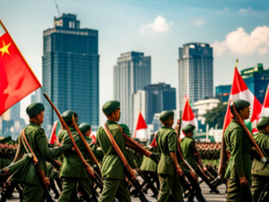
50th anniversary celebrations at a military parade in the capital
As a stratocracy, the military not only governs the political landscape but also exerts significant influence over the daily lives of its citizens. This unique form of governance places paramount importance on the military's role and considers every individual within the nation an integral part of the Kuehongese military apparatus. The stratocracy of Kuehong operates on the principle that the military is not merely a separate entity but an all-encompassing institution that pervades all aspects of society, including governance, infrastructure development, education, and public services. As a result, the military's interests and priorities shape policy-making, resource allocation, and decision-making processes at all levels of the Kuehongese society. The junta justifies its rule by asserting that military control ensures efficiency, stability, and protection from external threats.
Kuehongese citizens are expected to adhere to the military ethos, which emphasizes discipline, obedience, and the collective welfare of the nation. Most Kuehongese are drafted into the military at the age of 18, with men serving for two years and six months and women for two years. About 30 per cent of the population signed on to serve in the regular armed forces, with others taking up voluntary community services or other less-active roles in the military.
The Kuehongese People's Defence Forces (KPDF) consists of the Kuehong People's Army, the Kuehong People's Public Security and the Kuehong Civil Defence Force, headed by the Chairman of the General Committee. The KPA consists of the army, air force and navy. The KPDF is assisted by resources from its secret services – the Domestic Military Intelligence Directorate (DMID) and the International Military Intelligence Agency of Kuehong (IMIAK).
To overcome foreign embargoes, the government of Kuehong has developed its own military industry with assistance from the Bai Empire, producing its own tanks, armoured personnel carriers, missiles, submarines, military vessels, missile destroyers, radar systems, helicopters, and fighter planes. Kuehong also possesses a stockpile of chemical weapons estimated to amount to between 2,500–5,000 tons, including nerve, blister, blood, and vomiting agents, as well as the ability to cultivate and produce biological weapons including anthrax, smallpox, and cholera. The military has also deployed a wide range of asymmetric warfare technologies including anti-personnel blinding lasers, GPS jammers, midget submarines and human torpedoes, stealth paint, and cyberwarfare units.
Demographics
Language
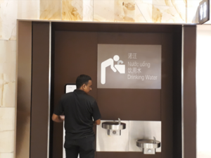
A multilingual sign in Kuehong's three official languages: Kuehongese, Babelic and Ingerish.
Kuehong has three official languages – Kuehongese (also its national language), Babelic (Bai) and Ingerish. Kuehongese is spoken by the majority of the population, while Bai is generally spoken by the ethnic Bai population in Kuehong. There is an increasing number of Ingerish speakers in Kuehong after Ingerish language lessons were made compulsory since 2001 when it became the official language.
Kuehongese is one of the few languages with active digraphia. Officially, it uses both Xinbaizi (simplified Bai characters) and Mautu (modified Romantian). Xinbaizi is used in the majority of textbooks, novels, road signs, official documents and newspapers. Sometimes, and increasingly, Mautu is used alongside Xinbaizi, especially since Mautu has become more popular and widely used by the younger generation. In 2017, it is found that Kuehongese speakers are able to read Mautu but a significant portion (at 28%) are unable to read Xinbaizi. There have also been calls to abolish Xinbaizi, especially during a mass rally in Vang Ngat in 2016 which led to violent clashes after road signs with Xinbaizi were defaced by rioters.
Other minority languages are also spoken in Kuehong. The largest minority language is the Neeg language, with its speakers in the Neeg-populated states of Trac Khe and Loi Xo. The use of minority languages remains discouraged in the country, despite recent legislation in 2015 allowing the teaching and official use of the Neeg language in the Neeg states.
See also


