Category:Castellan and OpenGeofiction talk:Antarephia: Difference between pages
(Difference between pages)
Rustem Pasha (talk | contribs) (Created page with "Category:Countries in West Uletha") |
(→Northeastern Antarephia - January 2023: new section) |
||
| Line 1: | Line 1: | ||
[[ | == Northeastern Antarephia - January 2023 == | ||
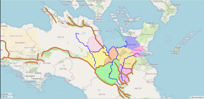
[[File:NE Antarephia.svg|400px|thumb|left|Draft for NE Antarephia partly implemented in Jan 2023]] | |||
* The green-dashed line is a possible relocation of some of the small island territories of NE Antarephia (Shown [https://opengeofiction.net/way/28783351#map=6/-29.122/40.979&layers=B on the map] after implementation) | |||
* Existing Lycian coast is pushed south (The sea has been left slightly transparent so that the original location is still visible) | |||
* The partly new mountain range (mountain ranges are in brown) that crosses purple, yellow, orange, green and re-purple territories is meant to be a "lesser" branch of the main transcontinental mountain range. This idea is to have high plateaus south of it, a bit like in the US Southwest or Mendoza Province in Argentina, as they have similar latitude and exposition, and provide mappers with similar OGF locations. | |||
* The large lakes in the apricot territory are meant to be deleted as they don't serve any purpose anymore. | |||
* Additionally, the new layout blocks most of E-W or N-S climate influence, making it easier to imagine how the weather, the landcover are like in this larger region. --[[User:Aiki|Aiki]] ([[User talk:Aiki|talk]]) 20:58, 24 January 2023 (UTC) | |||
Revision as of 20:58, 24 January 2023
Northeastern Antarephia - January 2023
- The green-dashed line is a possible relocation of some of the small island territories of NE Antarephia (Shown on the map after implementation)
- Existing Lycian coast is pushed south (The sea has been left slightly transparent so that the original location is still visible)
- The partly new mountain range (mountain ranges are in brown) that crosses purple, yellow, orange, green and re-purple territories is meant to be a "lesser" branch of the main transcontinental mountain range. This idea is to have high plateaus south of it, a bit like in the US Southwest or Mendoza Province in Argentina, as they have similar latitude and exposition, and provide mappers with similar OGF locations.
- The large lakes in the apricot territory are meant to be deleted as they don't serve any purpose anymore.
- Additionally, the new layout blocks most of E-W or N-S climate influence, making it easier to imagine how the weather, the landcover are like in this larger region. --Aiki (talk) 20:58, 24 January 2023 (UTC)
Media in category "Castellan"
The following 2 files are in this category, out of 2 total.
- 5band maldonado.png 501 × 284; 18 KB
- Castellan flag.png 1,545 × 1,030; 230 KB


