|
|
| Line 1: |
Line 1: |
| '''Welcome to OpenGeofiction!'''
| | ===How can I use JOSM for editing the OpenGeofiction map?=== |
|
| |
|
| We are glad you have joined us in this free, open, collaborative mapping project. By signing up, you now have access to edit on the map. Before you begin, however, please take a few moments to review this quick guide of a few important things to know:
| | If you want to use the JOSM editor, configure the "Connection settings" (via the "Edit -> Preferences" menu), so that the OSM server URL points to our server |
| | https://opengeofiction.net/api |
| | as shown here: <br> [[File:Luciano_Screenshot_JOSM_01.png|thumb|left]] <br clear=all> |
|
| |
|
| {| style="width:100%; margin:0; margin-left: auto; margin-right: auto; border: none;"
| | ===How can I display the OpenGeofiction map as background in JOSM?=== |
| |-
| |
| | style="width:33%;" |
| |
| {| class="wikitable" style=width:90%
| |
| ! style="background:#c6e6ff; color:#000000; text-align:center; height: 35px;" | Where can I edit?
| |
| |-
| |
| |
| |
| Now that you have signed up, you can begin editing freely in one of the '''<span style="color:#4488ff">█ blue territories</span>''' on our [[OGF:Territories#Overview Map|overview map]]. These blue-colored territories are free for all users to edit and governed by [[OGF:Blue territory etiquette|guidelines of etiquette]]. Be sure to leave [[Help:Good edit comments|good edit comments]] that are descriptions of your upload.
| |
|
| |
|
| All users are required to begin mapping in blue territories. Once you have some sample mapping to show off, you can ask to join [[OGF:List of collaborative projects|a collaborative project]].
| | To display the OpenGeofiction map as background in JOSM, add our server to the "selected entries" in the "Imagery preferences", using the "+TMS" button, as shown in this screenshot: <br> [[File:Luciano_Screenshot_JOSM_02.png|thumb|left]] <br clear=all> "OpenGeofiction" should then appear in the "Imagery" menu. |
| |}
| |
| | style="width:34%;" |
| |
| {| class="wikitable" style=width:90%
| |
| ! style="background:#eeddff; color:#000000; text-align:center; height: 35px;" | What programs can I use to edit?
| |
| |-
| |
| |
| |
| One of the most convenient ways to begin editing is to use the iD in-browser editor. You can find this by clicking the "edit" link on the top of the map page. Mapping with iD requires that you are at zoom level 16 or higher.
| |
|
| |
|
| Another way of editing is to [https://josm.openstreetmap.de/wiki/Download download and install the free java-based tool JOSM]. This tool is favored by many mappers on this site, because of the increased functionality and numerous add-ons available. For help with setting up JOSM, click [[Help:Configuring JOSM for OpenGeofiction|click here]].
| | The input values for the OGF map layers are as listed below. |
| |}
| |
| | style="width:33%;" |
| |
| {| class="wikitable" style=width:90%
| |
| ! style="background:#eeddee; color:#000000; text-align:center; height: 35px;" | Common terms and phrases
| |
| |-
| |
| |
| |
| Some terms that you will encounter while editing are ''node'', ''way'', ''area'', and ''tag''. A ''node'' is a simple point on a map. ''Ways'' connect nodes like lines. When a ''way'' is makes a closed loop (like a circle or polygon), it is called an ''area''. A ''tag'' is kind of like a labeling system for all the things mentioned. Tagging a node as <code>place=town</code> will make sure the mapping renderer recognizes that point as a town. Adding the name tag gives the town its name.
| |
| |}
| |
| |}
| |
|
| |
|
| {| class="wikitable" style="width:100%" | | {| class="wikitable" |
| | ! Layer (5.) |
| | ! URL template (2.) |
| |- | | |- |
| | colspan=2 style="background:#FFEEEE;text-align:center;" | '''Remember our rules! Violating the rules may result in suspension or termination of your account.'''
| | | OGF-Carto (OSM's default style) || <code><nowiki>https://tile.opengeofiction.net/ogf-carto/{zoom}/{x}/{y}.png</nowiki></code> (Max zoom = 20) |
| |-
| |
| | style="text-align:center;" | [[File:Noun alien grey 2847018 mod.svg|60px]]<br/><span style="color:red">'''Be realistic'''</span>
| |
| |
| |
| * '''Keep it real.''' No fantasy, science fiction, joke territories, etc. See [[OpenGeofiction:Verisimilitude]].
| |
| |-
| |
| | style="text-align:center;" | [[File:Noun Brain 2290453.svg|60px]]<br/><span style="color:red">'''Be original'''</span>
| |
| |
| |
| * '''No imports from OSM. No copying trademarked maps.''' Doing these things may get you banned.
| |
| * No extensive copying of real world geography. Try to avoid using well-known place names, real or fictional. No real world companies or organizations.
| |
| * '''All images — photos and artwork — [[OGF:Uploading images|must be free to use]]''', and must contain a link to source and/or copyright info. All wiki text must be your own writing.
| |
| * No copying others' mapping, without their permission.
| |
| |-
| |
| | style="text-align:center;" | [[File:Noun respect 2985071.svg|60px]]<br/><span style="color:red">'''Be respectful'''</span>
| |
| |
| |
| * '''Show consideration'''. The admin team are volunteers. Please refer to [[Help:Frequently asked questions|the FAQ page]], [[Help:Portal|the help and resources portal]], [[OGF:Territory assignment|territory assignment procedures]] and [https://wiki.openstreetmap.org/wiki/Map_features OSM tagging guides] to first attempt self-support. Incomplete or repetitive messages will be ignored and may result in your account being blocked.
| |
| * '''No mapping in others' territories''' or '''moving the borders of others' territories''' without their permission. No writing about others' territories in the wiki without permission.
| |
| * Respect the open seas by following the [[OGF:Rules of the sea|rules for sea borders, islands, and shipping lines]]. '''Be careful when editing coastlines''' to ensure you do not accidentally flood the continent.
| |
| * Do not extend your territory beyond its shape on the [[OGF:Territories|overview map]]. For borders with unclaimed neighbors, keep them within 10 km of the original line.
| |
| * '''No sockpuppets'''. Only one account per user.
| |
| * '''No vandalism'''. No offensive or insulting content. Consult admin before forming any OGF-related group off-site
| |
| * No "empires of paper" in the wiki - '''avoid [[OGF:Wiki policy|overwikification]]'''.
| |
| |-
| |
| | style="text-align:center;" | [[File:Noun working 3211836.svg|60px]]<br/><span style="color:red">'''Be active'''</span>
| |
| |
| |
| * After a prolonged period of inactivity, we may mark your territory for withdrawal. Then, if still no activity happens or we don't otherwise hear from you during the following several weeks, we'll mark the territory as free for other users to claim, and close your account.
| |
| |- | | |- |
| | | OGF-Topo (OpenTopoMap's style) || <code><nowiki>https://tile.opengeofiction.net/ogf-topo/{zoom}/{x}/{y}.png</nowiki></code> (Max zoom = 17) |
| |} | | |} |
|
| |
|
| We look forward to seeing what you create. Happy mapping!
| | Once you completed this step, you can then select "OpenGeofiction" as background for the "Download" dialog: <br> [[File:Luciano_Screenshot_JOSM_03.png|thumb|left]] <br clear=all> |
| | |
| | |
| {{OGF documentation}}
| |
| [[Category:Official OGF Documentation]] | |
How can I use JOSM for editing the OpenGeofiction map?
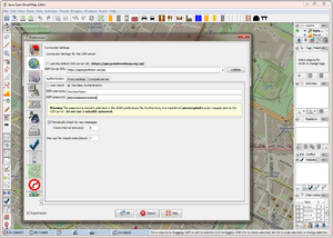
If you want to use the JOSM editor, configure the "Connection settings" (via the "Edit -> Preferences" menu), so that the OSM server URL points to our server
https://opengeofiction.net/api
as shown here:
How can I display the OpenGeofiction map as background in JOSM?
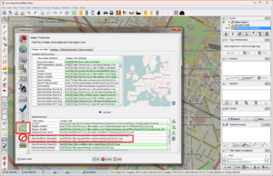
To display the OpenGeofiction map as background in JOSM, add our server to the "selected entries" in the "Imagery preferences", using the "+TMS" button, as shown in this screenshot:
"OpenGeofiction" should then appear in the "Imagery" menu.
The input values for the OGF map layers are as listed below.
| Layer (5.)
|
URL template (2.)
|
| OGF-Carto (OSM's default style) |
https://tile.opengeofiction.net/ogf-carto/{zoom}/{x}/{y}.png (Max zoom = 20)
|
| OGF-Topo (OpenTopoMap's style) |
https://tile.opengeofiction.net/ogf-topo/{zoom}/{x}/{y}.png (Max zoom = 17)
|
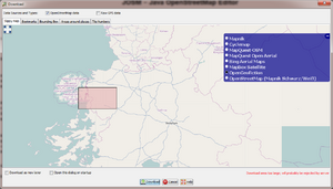
Once you completed this step, you can then select "OpenGeofiction" as background for the "Download" dialog:


