File:Canton flag of Seƚi.svg and Forum:Territory application/AN125, AN133, AN105, AN127 - Vastia: Difference between pages
(Timboh uploaded a new version of File:Canton flag of Seƚi.svg) |
No edit summary |
||
| Line 1: | Line 1: | ||
== | |||
== | <div class="forumheader" style="margin: 1; background-color: #eeeeee; text-align: left; padding: 5px;">'''[[Forum:Index|Forums]] → [[Forum:Territory application|Territory application]] → {{PAGENAME}}'''</div> | ||
[[Category:Territory application posts]] | |||
[[ | |||
== | <!-- Replace all WRITE HERE items with your application specifics, be sure to preview the page. Preview also displays extra explanation for each section --> | ||
{{ | <!-- Expert user? change one bit of text and then use the pencil icon to switch to Source Editing --> | ||
:''Please fill in the information below to make a territory request.'' | |||
{{Territory application id and name}} | |||
AN125, AN133, AN105, AN127 - Vastia (''collaborative project'') | |||
{{territory application physical geography}} | |||
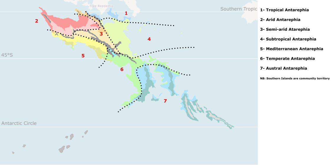
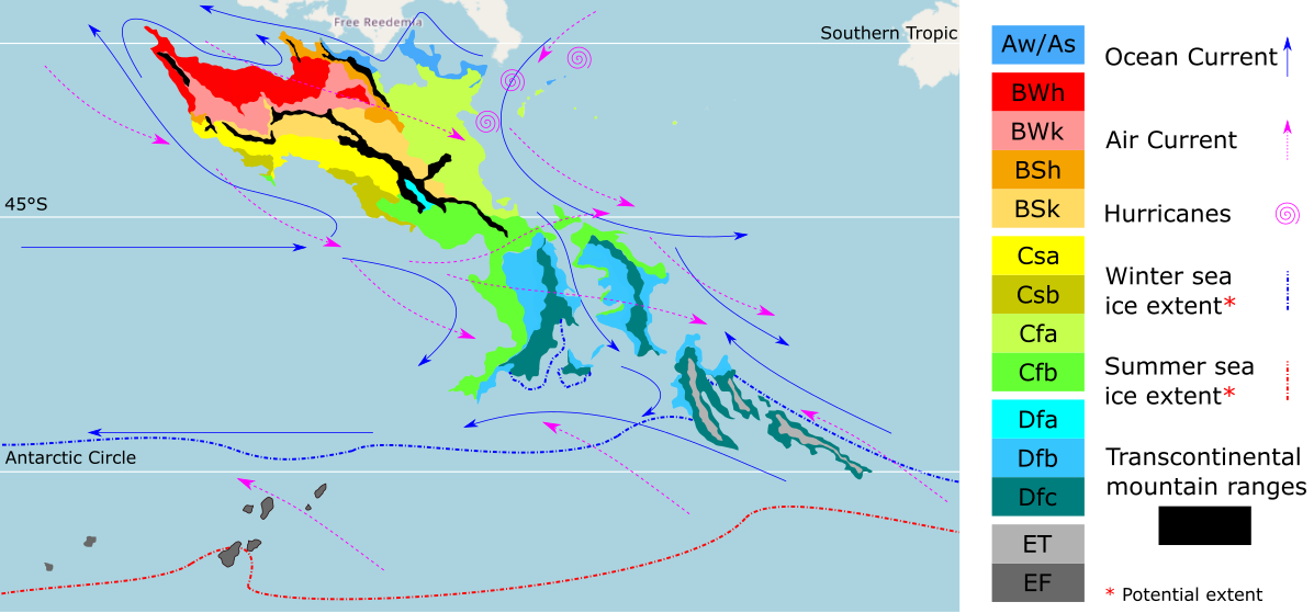
Vastia is expected to be mostly covered by desert and semi-arid areas (predominantly in '''[https://opengeofiction.net/relation/380#map=6/-29.554/21.385&layers=B AN125]'''), following the regional consensus presented in [https://wiki.opengeofiction.net/images/c/c5/Antarephia_Geo_Sector.png this image]. The remaining territory is expected to include minor tropical ([https://opengeofiction.net/relation/397#map=7/-24.843/24.093&layers=B '''AN127''']) and subtropical areas ([https://opengeofiction.net/relation/404 '''AN133'''] and '''[https://opengeofiction.net/relation/313688#map=9/-28.1202/35.0704&layers=B AN105]'''). Climatically speaking, we will follow the [https://wiki.opengeofiction.net/images/6/67/Antarephia_Climate.png regional consensus]: predominantly [[Wikipedia:en:Desert climate#Hot%20desert%20climates|BWh]] and [[Wikipedia:en:Desert climate#Cold%20desert%20climates|BWk]]; in a minor extent, [[Wikipedia:en:Semi-arid climate#Hot%20semi-arid%20climates|BSh]], [[Wikipedia:en:Humid subtropical climate|Cfa]] and [[Wikipedia:en:Tropical savanna climate|Aw/As]]. | |||
Vastia is also expected to have sections of some of the [https://wiki.opengeofiction.net/images/6/67/Antarephia_Climate.png transcontinental mountain ranges], that will serve as sort of a buffer zone between the arid climates/areas and more humid ones. Due to the predominant position of desert in the country, most of it will be plain, with a maximum height of about 3,500 m.a.s.l.n. [https://opengeofiction.net/user/Imperator Imperator], which is submitting this proposal with me, developed a rough sketch of geography for [https://opengeofiction.net/relation/380#map=6/-29.554/21.385&layers=B AN125] on the Arhet website (you can see it [https://arhet.rent-a-planet.com/#map=6/12.790/-11.052&layers=W here]; please ignore the nearby random motorways). | |||
{{territory application human geography}}As explained in the ''History and culture'' section of the application, there will be five major linguistic groups in Vastia: '''Nizianics, Vastians, Talecians, Corvanish and Regalians'''. They are expected to be organized into [[Wikipedia:en:Region|regions]], [[Wikipedia:en:Province|provinces]] and [[Wikipedia:en:Municipality|municipalities]]. The economy of Vastia is based on [[Wikipedia:en:Mining|mining]], [[Wikipedia:en:Petroleum extraction|petroleum extraction]], and diverse [[Wikipedia:en:Manufacturing|manufacturing industries]]. Most of the territory will be infertile, since it is covered by desert or semi-arid areas. The most fertile areas are on the coast (near Cygagon, Dacategia, Brocéliande and Soboko Republic), and the southeast of the expected country (fundamentally the [https://opengeofiction.net/relation/404 AN133 territory]). The most developed infrastructure will be found in coastal areas, centers where oligarchs reside, and at extraction points; while the rest of the country would have a weak infrastructure, similar to countries in the [[Wikipedia:en:Maghreb|Maghreb]] or [[Wikipedia:en:Latin America|Latin America]]. | |||
Therefore, the mapping will be inspired by the previously mentioned areas and some countries in the [[Wikipedia:en:Middle East|Middle East]], such as [[Wikipedia:en:Saudi Arabia|Saudi Arabia]] and the [[Wikipedia:en:United Arab Emirates|United Arab Emirates]].{{territory application history and culture}} | |||
Vastia is expected to be inhabitated by various linguistic groups, as explained in our [https://imgur.com/gallery/d3kKYRS linguistic map]. Most of the languages that are expected to be used in Vastia will be [[Wikipedia:en:Constructed language|conlangs]], including: a mix between [[Wikipedia:en:Old Spanish|Old Spanish]] and [[Wikipedia:en:Sicilian language|Sicilian]]-[[Wikipedia:en:Maltese language|Maltese]] ('''Nizianics'''), mix between ''Old Spanish'' and [https://opengeofiction.net/#map=6/-35.021/37.244&layers=B Ohemian] ('''Vastians'''), mix between [[Wikipedia:en:Basque language|Basques]] and [[Wikipedia:en:Galician language|Galicians]] ('''Talecians'''), mix between [[wikipedia:en:Sardinian_language|Sardinian]] and ''Ohemian'' ('''Corvanish'''), [[Wikipedia:en:French language|Franquese]]; and mix between ''Old Spanish'', [[wikipedia:en:Sardinian_language|Sardinian]] and ''Ohemian'' ('''Regalians'''). We are still debating the historical origin of the linguistic groups, but it is likely to be originated by colonization or migration from the [[Wikipedia:en:Homeland|homelands]] of these languages. | |||
The country is expected to be governed through an [[Wikipedia:en:Oligarchy|oligarchic]] [[Wikipedia:en:Constitutional monarchy|semi-constitutional monarchy]], whose head of state, the king, is elected by the ''High Council'' (composed of the [[Wikipedia:en:Oligarchy|oligarchic]] leaders of each province). There is a parliament [[Wikipedia:en:Election|elected by the people]], but it is fundamentally influenced by the High Council and the King of Vastia. | |||
{{territory application past mapping}} | |||
From [https://opengeofiction.net/user/Mapping%20Expert Mapping Expert] and [https://opengeofiction.net/user/Imperator Imperator]: | |||
*{{coord | |||
| name = State of Costa Dorada, Federal States | |||
| zoom = 7 | |||
| latitude = -27.980 | |||
| longitude = 141.691 | |||
| layer = B | |||
}} | |||
*{{coord | |||
| name = Former state of Trinity Island, Federal States | |||
| zoom = 8 | |||
| latitude = -42.519 | |||
| longitude = 161.724 | |||
| layer = B | |||
}} (currently named Hyde, some minor changes were made by the new owner) | |||
*{{coord | |||
| name = Lentië mountain range | |||
| zoom = 8 | |||
| latitude = 56.034 | |||
| longitude = 44.857 | |||
| layer = B | |||
}} | |||
*{{coord | |||
| name = Hertogswilt, Lentië | |||
| zoom = 15 | |||
| latitude = 56.7488 | |||
| longitude = 44.6050 | |||
| layer = B | |||
}} | |||
*{{coord | |||
| name = Sirrhae (Tarephia) | |||
| zoom = 10 | |||
| latitude = 20.4817 | |||
| longitude = 32.7351 | |||
| layer = B | |||
}} | |||
*[https://arhet.rent-a-planet.com/#map=5/-19.560/-14.326&layers=W '''Imperium'''], the most important project of the [https://wiki.geofictician.net/wiki/index.php/Arhet Arhet community] and a milestone in our mapping careers. | |||
**[https://arhet.rent-a-planet.com/#map=5/-33.468/-18.984&layers=W Vastia and Siccum deserts] in southern Imperium (from Partagia to Atrocaea). | |||
*[https://arhet.rent-a-planet.com/#map=6/-25.582/22.412&layers=W Tiudunhaim], a project in the Arhet community inspired by the many duchies that existed in modern [[Wikipedia:en:Germany|Germany]]. | |||
*[https://arhet.rent-a-planet.com/#map=5/-39.876/-32.783&layers=W Southwestern Aretia], a region fundamentally related to Imperium, including countries like Mandagora, Arpitania, Ecija, Tizona and Hircania, among others. | |||
*[https://arhet.rent-a-planet.com/#map=5/-16.468/30.410&layers=W Natural mapping of Western Aretia], the main continent in the Arhet community. | |||
{{territory application username and date}} | |||
[[User:Mapping Expert|Mapping Expert]] ([[User talk:Mapping Expert|talk]]) 02:09, 25 November 2022 (UTC) | |||
{{territory application discussion}} | |||
Thank you for your application and the links to Imperator's past mapping. I've also had a look at your mapping history as it wasn't provided. | |||
Unfortunately, your request for Vastia is indeed too ''vast'' to be considered as it is. | |||
* AN105 is meant to be for potential owners wishing to map a small to medium-sized island territory | |||
* AN127, due to its "small" size, is likely to be recommended to mappers mapping alone | |||
* AN125, due to its larger-than-most-territories size, would be ideal for a collaboration as understood by the OGF community, meaning, among others, rules for decision taking, mapping style... and adherence to them on top of the usual adherence to OGF site rules. | |||
* AN133 is a good [https://wiki.opengeofiction.net/util/relation_area.html?map=C/6/-33.09176/30.84054&q=AN133%20-%20Land 333,330 sq km] large (6 to 7 times larger than Costa Dorada), with access to the Strait of Lyc system to the north and bordered by the Trans-Antarephian mountain range to the south. Out of the territories you're requesting, I would frankly recommend to refocus on this one for a shared-ownership. | |||
If AN133 (or Antarephia) still interests you both, you may contact AN133's neighbours to know a bit more about their territories' natural features, demographics, culture, economics, history...so you can sketch something that can somehow fit in. I reckon, from the links you provided to the Antarephia page's images, that you have noticed the section on the [[OpenGeofiction:Antarephia#Cultural_groups|cultural groups]], indicating that "Antarephia is mainly made up of indigenous cultures, usually with their own conlang(s) or substrate(s), with limited Ulethan influence". I'm unsure the vast array of "Ulethan" languages you indicated could be the bedrock of its culture though. Thank you for your understanding and happy mapping, --[[User:Aiki|Aiki]] ([[User talk:Aiki|talk]]) 23:17, 25 November 2022 (UTC) | |||
Hi Aiki! Thank you for your feedback regarding the request. For now, I think we are still interested in looking for a territory in Antarephia, but it would be interesting to know if there are other alternatives that might work for us. Imperator and I are evaluating options, and in case AN133 is the best option available, we want to know if it is possible to eventually expand the expected territory, as we believe that we can help to improve the development of the region. In case it is not possible (and as I already mentioned to you previously), it would be good to know options where eventual development can be handled. Happy mapping, [[User:Mapping Expert|Mapping Expert]] ([[User talk:Mapping Expert|talk]]) 04:11, 26 November 2022 (UTC) | |||
: Hi, expansion requests will be reviewed in due time, taken into account how much of the territory then owned is mapped, the quality and variety of the mapping style, relations with neighbouring owners, OGF rules adherence...how big the expansion is, how often territories in this area are then requested...various parameters that makes impossible to answer your question now. --[[User:Aiki|Aiki]] ([[User talk:Aiki|talk]]) 16:13, 26 November 2022 (UTC) | |||
: Got it. We're exploring another territories in the area, including AN137f. What are the plans for the territory and what would be the chances (if we come up with a proper plan) of eventually getting the territory? [[User:Mapping Expert|Mapping Expert]] ([[User talk:Mapping Expert|talk]]) 17:20, 26 November 2022 (UTC) | |||
<!-- replace this with {{territory application approved|summary of decision and signature|optionally useful information for the user}} or {{territory application closed|summary of decision and signature|optionally useful information for the user}} on closing --> | |||
{{territory application in progress}} | |||
Revision as of 17:20, 26 November 2022
- Please fill in the information below to make a territory request.
| Territory ID and proposed name | |
|---|---|
| The Territory ID (from OpenGeofiction:Territories, e.g. AR123a) and proposed name of the country |
AN125, AN133, AN105, AN127 - Vastia (collaborative project)
| Physical geography | |
|---|---|
| An overview of climate, topography and landscape of the country. It is advised to also create a sketch, you can add a link to this (hosted on imgur or similar) |
Vastia is expected to be mostly covered by desert and semi-arid areas (predominantly in AN125), following the regional consensus presented in this image. The remaining territory is expected to include minor tropical (AN127) and subtropical areas (AN133 and AN105). Climatically speaking, we will follow the regional consensus: predominantly BWh and BWk; in a minor extent, BSh, Cfa and Aw/As.
Vastia is also expected to have sections of some of the transcontinental mountain ranges, that will serve as sort of a buffer zone between the arid climates/areas and more humid ones. Due to the predominant position of desert in the country, most of it will be plain, with a maximum height of about 3,500 m.a.s.l.n. Imperator, which is submitting this proposal with me, developed a rough sketch of geography for AN125 on the Arhet website (you can see it here; please ignore the nearby random motorways).
 | Human geography |
|---|---|
| A brief description of the territory demographics, economic development, land occupation, infrastructure and mapping style |
As explained in the History and culture section of the application, there will be five major linguistic groups in Vastia: Nizianics, Vastians, Talecians, Corvanish and Regalians. They are expected to be organized into regions, provinces and municipalities. The economy of Vastia is based on mining, petroleum extraction, and diverse manufacturing industries. Most of the territory will be infertile, since it is covered by desert or semi-arid areas. The most fertile areas are on the coast (near Cygagon, Dacategia, Brocéliande and Soboko Republic), and the southeast of the expected country (fundamentally the AN133 territory). The most developed infrastructure will be found in coastal areas, centers where oligarchs reside, and at extraction points; while the rest of the country would have a weak infrastructure, similar to countries in the Maghreb or Latin America.
Therefore, the mapping will be inspired by the previously mentioned areas and some countries in the Middle East, such as Saudi Arabia and the United Arab Emirates.
| History & culture | |
|---|---|
| A brief description of the intended culture and language |
Vastia is expected to be inhabitated by various linguistic groups, as explained in our linguistic map. Most of the languages that are expected to be used in Vastia will be conlangs, including: a mix between Old Spanish and Sicilian-Maltese (Nizianics), mix between Old Spanish and Ohemian (Vastians), mix between Basques and Galicians (Talecians), mix between Sardinian and Ohemian (Corvanish), Franquese; and mix between Old Spanish, Sardinian and Ohemian (Regalians). We are still debating the historical origin of the linguistic groups, but it is likely to be originated by colonization or migration from the homelands of these languages.
The country is expected to be governed through an oligarchic semi-constitutional monarchy, whose head of state, the king, is elected by the High Council (composed of the oligarchic leaders of each province). There is a parliament elected by the people, but it is fundamentally influenced by the High Council and the King of Vastia.
| Past mapping | |
|---|---|
| To support your request provide links to areas of OGF mapping which showcase your mapping skill. Mapping relevant to the requested theme & geography is especially useful | |
| The {{coord}} template can optionally be used to link to the OGF map - it results in a nice formatted link. Or you can paste in a URL. |
From Mapping Expert and Imperator:
 State of Costa Dorada, Federal States
- Former state of Trinity Island, Federal States (currently named Hyde, some minor changes were made by the new owner)
- Lentië mountain range
- Hertogswilt, Lentië
- Sirrhae (Tarephia)
- Imperium, the most important project of the Arhet community and a milestone in our mapping careers.
- Vastia and Siccum deserts in southern Imperium (from Partagia to Atrocaea).
- Tiudunhaim, a project in the Arhet community inspired by the many duchies that existed in modern Germany.
- Southwestern Aretia, a region fundamentally related to Imperium, including countries like Mandagora, Arpitania, Ecija, Tizona and Hircania, among others.
- Natural mapping of Western Aretia, the main continent in the Arhet community.
| Username & date | |
|---|---|
| Sign and date the application by typing four tildes like this: ~~~~ |
Mapping Expert (talk) 02:09, 25 November 2022 (UTC)
 | Discussion |
|---|---|
| Discussion for clarification & decision |
Thank you for your application and the links to Imperator's past mapping. I've also had a look at your mapping history as it wasn't provided.
Unfortunately, your request for Vastia is indeed too vast to be considered as it is.
- AN105 is meant to be for potential owners wishing to map a small to medium-sized island territory
- AN127, due to its "small" size, is likely to be recommended to mappers mapping alone
- AN125, due to its larger-than-most-territories size, would be ideal for a collaboration as understood by the OGF community, meaning, among others, rules for decision taking, mapping style... and adherence to them on top of the usual adherence to OGF site rules.
- AN133 is a good 333,330 sq km large (6 to 7 times larger than Costa Dorada), with access to the Strait of Lyc system to the north and bordered by the Trans-Antarephian mountain range to the south. Out of the territories you're requesting, I would frankly recommend to refocus on this one for a shared-ownership.
If AN133 (or Antarephia) still interests you both, you may contact AN133's neighbours to know a bit more about their territories' natural features, demographics, culture, economics, history...so you can sketch something that can somehow fit in. I reckon, from the links you provided to the Antarephia page's images, that you have noticed the section on the cultural groups, indicating that "Antarephia is mainly made up of indigenous cultures, usually with their own conlang(s) or substrate(s), with limited Ulethan influence". I'm unsure the vast array of "Ulethan" languages you indicated could be the bedrock of its culture though. Thank you for your understanding and happy mapping, --Aiki (talk) 23:17, 25 November 2022 (UTC)
Hi Aiki! Thank you for your feedback regarding the request. For now, I think we are still interested in looking for a territory in Antarephia, but it would be interesting to know if there are other alternatives that might work for us. Imperator and I are evaluating options, and in case AN133 is the best option available, we want to know if it is possible to eventually expand the expected territory, as we believe that we can help to improve the development of the region. In case it is not possible (and as I already mentioned to you previously), it would be good to know options where eventual development can be handled. Happy mapping, Mapping Expert (talk) 04:11, 26 November 2022 (UTC)
- Hi, expansion requests will be reviewed in due time, taken into account how much of the territory then owned is mapped, the quality and variety of the mapping style, relations with neighbouring owners, OGF rules adherence...how big the expansion is, how often territories in this area are then requested...various parameters that makes impossible to answer your question now. --Aiki (talk) 16:13, 26 November 2022 (UTC)
- Got it. We're exploring another territories in the area, including AN137f. What are the plans for the territory and what would be the chances (if we come up with a proper plan) of eventually getting the territory? Mapping Expert (talk) 17:20, 26 November 2022 (UTC)
File history
Click on a date/time to view the file as it appeared at that time.
| Date/Time | Thumbnail | Dimensions | User | Comment | |
|---|---|---|---|---|---|
| current | 18:48, 10 July 2022 |  | 512 × 317 (9 KB) | Timboh (talk | contribs) | Thicker cross to match city of Seli flag |
| 21:32, 6 November 2021 | Error creating thumbnail: File missing | 512 × 317 (4 KB) | Timboh (talk | contribs) | ==Summary== Canton flags made for Navenna. Own work. Category:NavennaCategory:Flags ==License== {{cc-by-nc-sa}} |
You cannot overwrite this file.
File usage
The following page uses this file: