Minnonigan

|
State of Minnonigan Capital: Thomasford
Population: 6,038,442 (2020) Motto: "Great places, open spaces, and smiling faces" |
Loading map... |
Minnonigan, officially the State of Minnonigan, is a state in the southwestern Federal States. The state's name derives from a Native Archantan word meaning "pleasant portage". With just over six million residents, Minnonigan is the second-most populous state in the West Lakes region of the Federal States. The state is situated between Lake Amanecer and Lake Sauganash, surrounded by the state of Illuvia to the north; Iroquesia to the east; and AR120-56 to the south. Minnonigan also has land borders with the nation of Deodeca to the west. Minnonigan is known for its flat, rich soils in much of its central and southern portions and lush, rolling hills in the far northern parts of the state. Minnonigan's topography combined with its humid continental "four seasons" climate make Minnonigan one of the FSA's most agriculturally-productive states, especially with corn and soy crops.
The area now known as Minnonigan had been populated by Native Archantans for hundreds of years before Franquese explorers settled in the West Lakes area during the 17th Century. Despite explorations by the Franquese and later the Castellanese, the major Ulethan colonizers made little attempt to have a sizeable presence in the area until following the independence of the Federal States. With western Federal States expansion and increased commerce through the West Lakes, Minnonigan became a transportation and logistics hub with the opening of the Ondassagam Waterway system that directly connected Lake Amanecer, Lake Sauganash, and the Akogama River valley without requiring either portaging between the lakes or taking a more circuitous route via Lake Betaouais, which was particularly dangerous during the winter months. Minnonigan's stature would only increase with the construction of the railroads, which combined with the Wahauja Purchase to the north allowed for the construction of the FSA's first transcontinental railroad, circumnavigating the western mountain ranges to link the Ardentic and Asperic oceans.
The opening of the Ondassagam Waterway was also responsible for the rapid ascent and growth of the City of Lake City, which subsequently became one of the most important rail and intermodal freight hubs in the Federal States. Transportation and logistics remain a key industry for Lake City, which in the modern era includes one of the world's busiest commercial airports. Lake City is also the cultural hub of Minnonigan, boasting numerous universities, theaters, entertainment districts, and professional sports teams, as well as serving as the host of the 2000 Summer Pax Nova Games. Other important cities in Minnonigan include Ondassagam, at the western end of the eponymous waterway network; Thomasford, the state capital; Barre Harbor, a key port of entry between Deodeca and the Federal States; and Brenton, which hosts the flagship University of Minnonigan.
Geography
 | |
|---|---|
| Geography of Minnonigan | |
| Continent | Archanta (Astrasia) |
| Region | West Lakes |
| Population | 6,038,442 (2020) |
| Area | |
| • Total | 47767.69 km2 18443.21 sq mi |
| • Water (%) | 9.7% |
| Population density | 126.97 km2 327.41 sq mi |
| Major rivers | Stone, Thomas, Minnonigan, Gray |
| Time zone | WUT+9:00 |
Minnonigan is situated between Lake Sauganash and Lake Amanecer in the West Lakes region of the Federal States. The state is bordered by the state of Illuvia to the north; the state of Iroquesia to the east; the state of AR120-56 to the south; and the country of Deodeca to the west. Due to Lake Amanecer, Minnonigan shares two separate land boundaries with Deodeca: in the northwest, Minnonigan borders the Deodecan province of Nawagan, while southwestern Minnonigan borders Agawaskway near Barre Harbor and Nishaukee Falls.
Northern Minnonigan is defined by its rolling, hilly terrain, full of mineral resources such as coal. The northernmost point of Minnonigan is the southernmost noteworthy peak in the western mountain range. From these hills, the Stone and Thomas Rivers flow southerly through low rolling hills until the land flattens out into rich, arable prairies. The Thomas River flows into the Stone River just north of the Lake County line, flowing through Lake City on its way to Lake Sauganash. In western Minnonigan, a small midcontinental ridge separates the Thomas River from the Canton River, which flows into Lake Amanecer. The Thomas and Canton Canal, the first crucial link in the Ondassagam Waterway network, was constructed in 1838 to allow large ships to transit between Lake Sauganash and Lake Amanecer via the Canton and Thomas Rivers, bypassing inland waterways in Deodeca and Lake Betaouais. The Ondassagam Waterway network also includes an additional canal constructed to link the Stone River with the Gray River for more direct access to the Akogama River system.
Minnonigan and Seneppi -- or more specifically, the cities of Lake City and Wallawaukee -- have been friendly (and occasionally, not-so-friendly) rivals since the opening of the inland waterway network, as regional freight can more easily bypass Wallawaukee in favor of Lake City.
Climate
Under the Köppen climate classification, most of Minnonigan is considered to have a hot-summer humid continental climate (Köppen Dfa), with a variety of weather throughout all four seasons. Lake Sauganash and Lake Amanecer provide some moderating influences for areas along the immediate shorelines.
Metropolitan areas
The largest metropolitan area in the state is the Lake City region, which encompasses all of Lake County and parts of numerous additional counties, including some development in neighboring Iroquesia. Other major metropolitan areas include Barre Harbor along the boundary of Deodeca, the Ondassagam area, and the Thomasford area, which serves as the state's capital.
Government
State Government
| Government of Minnonigan | |
|---|---|
| Representative democracy | |
| Capital | Thomasford |
| Head of state | |
| • Governor | Scarlett Peckynski |
| • Lieutenant Governor | John Stephens |
| Legislature | Minnonigan Bicameral |
| • Upper house | State Senate |
| • Lower house | General Assembly |
| Judiciary | Supreme Court of Minnonigan |
Major political parties | |
Recognized Workers, Farmers, and Artisans (WFA) Minnonigan Business and Trade Alliance (BTA) Conservative Party of Minnonigan (Con) Fringe parties Neo-Federalist Party (NF) Minnonigan United Progressive Party (MUPP) Faith, Family, and Freedom Party (3F) Grand Lake Secessionists (GLS) | |
 | |
|---|---|
| Administrative divisions of Minnonigan | |
| First-level | 32 counties |
| Second-level | 275 townships |
| Third-level | cities, towns, and villages |
The government of the State of Minnonigan is based in Thomasford, with some satellite executive offices in Lake City. The Bicameral, the Minnonigan state legislature, is composed of the General Assembly and the State Senate. Members of the General Assembly are known as "Representatives" and are elected every two years; Senators serve a term of six years, with rotating elections such that one-third of the State Senate is up for election every two years. Each Senate District is composed of three House Districts, which are redrawn every ten years. Currently there are 99 Representatives and 33 Senators in the Bicameral.
The Governor of Minnonigan leads the executive branch of state government. Governors serve four-year terms and are term-limited to serve no more than eight years.
The Supreme Court of Minnonigan represents the highest judicial branch of the Minnonigan state government. There are 17 Justices on the Supreme Court, each of whom serve a single 17-year term. Every year one new Justice is appointed by the Governor (with the approval of the State Senate); this system ensures that turnover on the Supreme Court is regular but no single Governor can appoint a majority of the Justices.
The State of Minnonigan uses a "jungle primary" system, where all candidates from all parties run on the same ballot for state offices. A candidate can immediately win their election if they win a majority (50%+1) of votes in the jungle primary; if no candidate wins a majority, a general election is held with the top four vote-getters advancing to the general election. Voters then use ranked-choice voting to elect a candidate.
County Government
Minnonigan is divided into 32 counties.
| County Name | County Seat | Population | Area (km²) | Area (mi²) | Number of townships |
|---|---|---|---|---|---|
| Amanecer County | 1,929.38 | 744.94 | 11 | ||
| Ashleigh County | Ketiguah | 1,889.38 | 729.49 | 15 | |
| Blackrock County | 1,305.71 | 504.14 | 10 | ||
| Bucks County | Ondassagam | 1,923.68 | 742.74 | 14 | |
| Chester County | 1,361.35 | 525.62 | 10 | ||
| Chissawon County | 1,094.99 | 422.78 | 9 | ||
| D'Amico County | Potterston | 1,135.19 | 438.30 | 11 | |
| Frampton County | 1,095.24 | 422.87 | 7 | ||
| Frontera County | 1,294.53 | 499.82 | 3 | ||
| Fulton County | 1,361.76 | 525.78 | 10 | ||
| Ginnelle County | 1,779.76 | 687.17 | 12 | ||
| Gray County | Gibson's Ferry | 1,926.50 | 743.82 | 12 | |
| Insull County | 1,162.31 | 448.77 | 9 | ||
| Jasper County | Swanahaw | 918.26 | 354.54 | 7 | |
| Jonas County | Jonasburg | 1,052.35 | 406.31 | 7 | |
| Kane County | 1,378.28 | 532.16 | 10 | ||
| Kent County | 1,779.03 | 686.89 | 13 | ||
| Lake County | Lake City | 974.74 | 376.35 | 7* | |
| Lanley County | 1,718.58 | 663.55 | 13 | ||
| Larchmont County | North Thomasford | 2,239.46 | 864.66 | 16 | |
| Marion County | Carbonridge | 1,407.55 | 543.46 | 10 | |
| Michawaga County | Montaguite | 1,976.48 | 763.12 | 12 | |
| Monroe County | Monroe | 550.44 | 212.52 | 3 | |
| Murphy County | Brenton | 1,954.15 | 754.50 | 14 | |
| Nishaukee County | Barre Harbor | 2,818.32 | 1,088.16 | 17 | |
| Oconto County | 1,144.93 | 442.06 | 10 | ||
| Patchke County | 971.61 | 375.14 | 7 | ||
| Rush County | Wallace | 1,689.27 | 652.23 | 11 | |
| Scarlett County | Scarlett Hill | 1,134.26 | 437.94 | 9 | |
| Stone River County | 1,457.68 | 562.81 | 11 | ||
| Sunset County | 1,871.15 | 722.45 | 6 | ||
| Wilson County | 1,261.61 | 487.11 | 9 |
* - Two townships in Lake County that are entirely within the City of Lake City and/or the City of Daviston no longer exist as legal entities.
Township Government
Minnonigan is divided into 275 townships. Townships are generally responsible for basic infrastructure services in unincorporated areas that are not otherwise performed by county governments, most typically including building and maintaining non-state highways. Incorporated areas are generally served by municipal governments rather than township governments.
Municipal Government
Municipalities in Minnonigan are classified as either villages, towns, or cities. This classification is based on municipal government structure rather than population.
- Villages are governed by a Village President and a Board of Trustees, all of whom are elected at-large. The Village President is part of the Board of Trustees and votes accordingly.
- Towns are governed by a Board of Commissioners, each of whom oversees part of the municipal government. Commissioners are elected at-large; following the first seating of the Commission, commissioners elect their own President to preside over the Board. Towns should not be confused with townships.
- Cities are governed by a City Council, comprised of Aldermen who each represent a part of the city (a "Ward"). There are no limits to how many Wards a city may have, and cities are also permitted to allow citywide at-large Aldermen. The City Council is presided over by a Mayor, who is elected at-large but does not vote in the City Council except to break ties.
Infrastructure
| Infrastructure of Minnonigan | |
|---|---|
| Roadways | |
| • Driving side | Right |
| Railways | |
| • Passing side | Varies |
| • Gauge | 1435mm |
| • Electrification | No (except LakeLynx) |
| Telephone code | +611-55 |
Highways
Major highways throughout the state of Minnonigan are controlled by the Minnonigan Department of Transportation (MDOT). All MDOT highways are numbered, with primary highways numbered using single digits 1 through 8. Secondary highways, which connect other areas to the primary highway system, are two digits, with the first digit the same as its corresponding primary highway. Tertiary highways are likewise numbered with three digits, with the first two digits the same as its corresponding secondary highway (or, if the tertiary highway directly serves a primary highway, the first digit is the primary highway number, followed by zero). Numbered highways are generally referred to as "State Route XX" and are typically shown on maps as "SR XX".
900-Series Expressways
Beginning in 1947, Lake County and the City of Lake City began building a network of superhighways intended to alleviate traffic in and around Lake City. These superhighways were later added to the Minnonigan state highway network with 900-series route numbers, since there is no SR 9 in Minnonigan. These highways were also identified using unique shields to help identify them as high-speed, limited-access facilities. Many of the 900-series expressways and tollways became part of the Federal States Defense and Commerce Motorway Network.
Minnonigan Toll Highway Authority
To create a statewide network of these superhighways, the Minnonigan state legislature created the Minnonigan Toll Highway Authority (MTHA, also known colloquially as the Minnonigan Turnpike), charged with building tolled turnpikes throughout the state outside of Lake County to be funded and financed by tolls. Many of these turnpikes became part of the Federal States Defense and Commerce Motorway Network. While Minnonigan's turnpikes are similar to Lake County's freeways, they generally have fewer entrances and exits to more efficiently channelize traffic to toll booths. Unique toll highway shields are used on turnpikes to more quickly identify them as tolled facilities. In 1996, the MTHA created the ePass electronic toll responder program, which allows motorists to pay tolls using an electric transponder which is linked to a bank account or credit card. In 2001, the Sunset Shore Beeline (new FS-920) became Minnonigan's first turnpike with full-speed mainline ePass lanes, allowing drivers to pay tolls while traveling at highway speeds. Since then, high-speed tolling has been expanded to all mainline toll plazas. ePass is accepted at all MTHA toll plazas as well as on the Hutchinson and Stone Heights toll bridges over the Stone River.
Historic motor trails
Loading map...
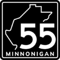
Minnonigan state highway shield for State Route 55, a secondary highway of SR 5.
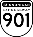
Minnonigan 900-series shield for State Route 901. While SR 901 was largely replaced by FS-89 and FS-91, a portion of SR 901 remains in northeastern Minnonigan, linking FS-89 near Sebert with FS-85 north of Hazlet Lake.

Minnonigan 900-series shield for tolled portions of State Route 900, the Northeast Turnpike, an 10-mile-long suburban tollway northeast of Lake City.

On segments of the Federal States motorway network that are also part of the Minnonigan Turnpike, special combined shields are used.

Minnonigan Motor Trail shield for the Gleason Trace.


Railways
Minnonigan established itself as a railway hub of the Federal States in the mid-19th Century, as one of the FSA's first transcontinental railroads (now known as the Sauganash and Northern Railroad) was planned through the state; the state's modest topography and location south of the western mountain range allowed for construction of a transcontinental route through what is now Iroquesia and Clamash to Asperic ports in Tauhon. The Minnonigan Central Railroad, which links Lake City to ports in Alormen, is also a major freight carrier in the state.
Seaports
Minnonigan has several major inland ports, notably on Lake Sauganash at Lake City and on Lake Amanecer at Port Bucks near Ondassagam. Larger lake-going ships are able to transload cargo to rail and truck transportation, or to smaller barges to navigate the state's inland waterway network.
Airports
Building on Minnonigan's location as a major transportation hub of the southwestern Federal States, the state has long been a regional pioneer in commercial aviation. Lake City International Airport (LCX) is located north of Lake City, just south of the Thomas River. The airport, with seven runways and 191 gates, is by far the largest airport in Minnonigan and one of the busiest in the southwestern Federal States. The airport serves as the primary airport for Lake City as well as for northern portions of Nishowigan. LCX opened in 1963 to replace Gunnison Airport, which in recent years has re-emerged as a major commercial airport in Minnonigan. Additional commercial airports are found near Barre Harbor, Ondassagam, and Carbonridge.
The state's airports were an early adopter of using lettered codes to represent its airports, using the established two-letter city codes for applicable airports (e.g., "LK" for Lake City, "CB" for "Carbonridge", "PB" for Point Blaire, etc.). When the three-letter WAAT codes became standardized internationally, most Minnonigan airports simply added a tailing "X" to their existing two-letter city code. Notable exceptions are LCX (which was named after Gunnison Airport was established and had already been using the "LKX" code) and Ondassagam (OG)'s "BUX" code, used to avoid confusion with the abbreviation for the state of Ogdalen, and to form a homophone code for Bucks County.
| City/Urban Area | Name | Code | Class | Gates | Runways | Location | Notes |
|---|---|---|---|---|---|---|---|
| Lake City | Lake City International Airport | LCX | G | 191 | 7 | Primary hub of Southern Airlines. Major hub of Federal Airlines. | |
| Lake City | Gunnison Airport | LKX | R | 41 | 2 | Primary hub of SkyRide Airlines. | |
| Ondassagam | Ondassagam-Bucks County Regional Airport | BUX | R | 21 | 2 | ||
| Carbonridge | Northern Minnonigan Regional Airport | CBX | R | 7 | 3 | ||
| Barre Harbor/Point Blaire | Gridland Gateway International Airport | PBX | R | 5 | 2 |
Communications
Telephone Codes
All non-domestic calls to Minnonigan begin with the (55) state code, or +611-55 from outside the Federal States. Phone numbers in Minnonigan are in the format AA-BB-CCCC, where:
- AA is the county or city code;
- BB is the local neighborhood exchange; and
- CCCC is the individual caller’s number.
Numbers within the same grouping can be dialed directly, omitting higher-level groupings (e.g., callers within the same county/city code can simply dial BB-CCCC; neighbors within the same local exchange can simply dial CCCC). Minnonigan launched one of the FSA’s first emergency calling codes, using 0000 statewide. Following the implementation of the national 011 emergency services number, callers can dial either 0000 or 011 to reach local police, fire, and paramedics.
| States | Alcortez • |
|---|---|
| Capital District | Huntington(c) |
| Overseas Territories | |