Forum:Territory application/UL33n République Fédérale de Tolulu
- Please fill in the information below to make a territory request.
| Territory ID and proposed name | |
|---|---|
| The Territory ID (from OpenGeofiction:Territories, e.g. AR123a) and proposed name of the country |
ID: UL33n
Full name: République Fédérale de Tolulu
Short name: Tolulu
Ingerish name: Federal Republic of Tolulu
| Physical geography | |
|---|---|
| An overview of climate, topography and landscape of the country. It is advised to also create a sketch, you can add a link to this (hosted on imgur or similar) |
Natural geography:
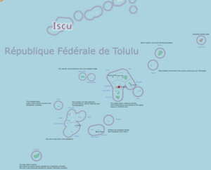
All the islands are atolls. On the Raphaël islands, (see Tolulu base map) some rocky insular remnants reach about 100m above the sea. Elsewhere, the highest point is just a few meters above the sea. Widest landmass is about a kilometer at most, where the average is merely a few 100 meters. The climate is tropical (Af), dominated by coral reefs and palm trees. Coconut and other palmtree plantations dominate the few arable areas. Transport is dominated by ships and boats with ferries connecting the various islands. Small aircraft and thus smaller airfields connect the more distant islands, as well as international destinations.
The country is situated in the Plurinesian sea in the Ardentic ocean. entirely south of the Equator, with the island of Equatoreaux being very close to it. (the northern edge of the maritime border is just south of the equator, partially to avoid certain rendering issues)
The country is situated within the continental relation of Eastern Uletha, (see Tolulu overview map)
 | Human geography |
|---|---|
| A brief description of the territory demographics, economic development, land occupation, infrastructure and mapping style |
Economic geography
The country is very poor and is in a large part sustained by foreign invenstment capital from Franqueterre, some tourism, plantations and fishing industry exists. But not nearly enough, leaving much of the population in poverty.
Population is low, somewhere between 8 000 - 20 000 people (see table below).
Due to the very small land area, the population is relatively dense, mapping style will be reminiscent of French Polynesia with many locations dominated by highway=track and highway=path, as well as mostly unpaved main roads. Buildings will be mostly sporadic and small-scale. (see past mapping below)
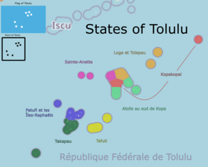
The major atolls, due to their isolation, operate somewhat independently as states despite their low population.
Inspirations
Main inspiration is the Tuamotu islands of French Polynesia but notable inspiration is also taken from atoll countries like Kiribati and the Marshall islands etc.
Table of estimated population per island and state:
| state | pop. | Island 1 | pop. | Island 2 | pop. | Island 3 | pop. | Island 4 | pop. |
| Kopakopai | 3740 | Kopakopai | 3598 | Equatoreaux | 142* | ||||
| Sainte-Anette | 762 | Tivati | 678 | Atoll d'Oulétha | 84 | Cap Vincent | 0 | ||
| Loga et Tolepau | 801 | Loga | 670 | Tolepau | 131 | Lipa ai | 0 | ||
| Atolls au sud de Kopa | 1005 | Île des Bancs | 431 | Île d'hiver | 79 | Tameetee | 390 | Fuma | 105 |
| Tafuti | 1080 | Tafuti Grande | 659 | Tafuti ele | 202 | Tuleelee | 219 | ||
| Takapau | 1167 | Takapau | 1071 | Île de Printemps | 96 | l'île du roi | 35* | ||
| Patufi et les Îles-Raphaëls | 589 | Karakora | 272 | Tapali | 160 | Kaupai | 51 | Patufi | 106 |
| total population (settlements) | 9144 | ||||||||
| (+5% for isolated dwellings) | 9601 | ||||||||
| (+15% for isolated dwellings) | 10516 | ||||||||
*These islands have no official population, number shows average personell on site.
| History & culture | |
|---|---|
| A brief description of the intended culture and language |
History
The country was first settled by native Asperic peoples around 800 BCE. Ingerish explorers discovered Equatoreax in 1516, Other islands of the Archipelago were discovered by a mixture of Ingerish, Franquese and Lentian expeditions in the following centuries. L'île du roi was the last island of the archipelago to be discovered in 1803.
Ulethan Colonialisation came to dominate the history of the islands from 1590 with the first being a Lentian trade post on the hitherto uninhabited Atoll d'Oulétha. Ingerish and Franquese settlers subsequently established various settlements on the islands. Colonial efforts were focused on the island of Kopakopai, which was the most arable and central atoll of the archipelago. Forcing the native population to mostly relocate to other islands. The island was primarily used as a trading post for transports between Archanta and Uletha. It became an official territory of Franqueterre in 1671 and remained that way until its independence in 1974 and today remains as part of a Franquese language union (something like an OGF version of La Francophonie), as well the country relying heavily of Franquese investment capital.
I hope to work on this together with Lithium-Ion who has expressed interest in collaborating on background and history.Culture and Language
The main language is a dialect of Franquese, primarily in the capital region. A Polynesian inspired conlang is used elsewhere. Namely Toluluan, part of the wider and established Asperic language family.
The islands around Kopakopai today have a mostly Franquese culture and language where the Raphaël islands, Tafuti and Takapau are more predominantly native Toluluan.
| Past mapping | |
|---|---|
| To support your request provide links to areas of OGF mapping which showcase your mapping skill. Mapping relevant to the requested theme & geography is especially useful | |
| The {{coord}} template can optionally be used to link to the OGF map - it results in a nice formatted link. Or you can paste in a URL. |
My previous mapping primarily consists of Ruoguovvás (UL12b) where some of my recent mapping could be seen as relevant for tropical, island mapping.
Old-town of Jiemie, with its narrow, winding alleys and low wooden houses
https://opengeofiction.net/#map=16/64.7314/66.8685&layers=B
Iqlujoq, with its isolated small-scale infrastructure
https://opengeofiction.net/#map=15/73.9829/52.9032&layers=BA while back, I was allowed to guest-map in Iscu, where I mapped a sizable portion of Pentecost, this is the only time I have mapped this style, and I greatly enjoyed it.
https://opengeofiction.net/#map=17/0.72397/89.43032&layers=B
Most notable however, is that I have mapped the sketch of Tolulu and the large scale mapping of the islands themselves. (see links below)
Picture of the full layer (untagged lines will be removed before uploading)
Zoomed in picture on one of the atolls
https://cdn.discordapp.com/attachments/1051932580439658596/1071907402225569792/Tolulu_example.PNG
| Username & date | |
|---|---|
| Sign and date the application by typing four tildes like this: ~~~~ |
Liadrien (talk) 05 February 2023
 | Discussion |
|---|---|
| Discussion for clarification & decision |
 |
Territory application approved |
|---|---|
| As discussed previously, nice concept and application. Approved. Please upload the sketches you made so far, I will add the relation to the territory admin pages afterwards. Leowezy (talk) 10:35, 7 February 2023 (UTC) | |
| optionally useful information for the user |


