Weekly site maintenance is scheduled Thursday 04:00–06:00 UTC.
Editing will not be possible during this time, and there may be other brief disruptions. (additional info)
File:Deodeca OutlinesofProvinces.png and Deodeca: Difference between pages
(Difference between pages)
Jump to navigation
Jump to search
No edit summary |
|||
| Line 1: | Line 1: | ||
== | {{disambig|the country in Archanta|the [[Collab:Deodeca|collaboration page]]|x}} | ||
{{Infobox country | |||
== | |coords_zoom = 4 | ||
{{ | |coords_lat = -41 | ||
|coords_long = 135.197 | |||
|common_name = Deodeca | |||
|image_flag = | |||
|national_motto =TBD | |||
|image_map = File:Deodeca LocationArchanta.png | |||
|map_caption = Location of Deodeca (red) in Archanta. | |||
|capital = TBD | |||
|largest_city = TBD | |||
|official_languages = [[Ingerish]] | |||
|ethnic_groups = | |||
|ethnic_groups_year = | |||
|religion = | |||
|demonym = Deodecan | |||
|government_type = TBD | |||
|leader_title1 =Monarch | |||
|leader_name1 =Geoffrey VII | |||
|leader_title2 =TBD | |||
|leader_name2 =TBD | |||
|leader_title3 =TBD | |||
|leader_name3 =TBD | |||
|legislature = Parliament of Deodeca | |||
|upper_house = Senate | |||
|lower_house = House of Representatives | |||
|area_km2 = 685,572 | |||
|area_sq_mi = 264,701 | |||
|population_census = TBD | |||
|population_census_year = 2019 | |||
|population_density_km2 = | |||
|population_density_sq_mi = | |||
|GDP_PPP = TBD | |||
|GDP_PPP_per_capita = | |||
|HDI = | |||
|HDI_year = 2020 | |||
|HDI_change = {{increase}} | |||
|timezone = WUT+09:00 | |||
|drives_on_the = right | |||
|currency = Deodecan dollar | |||
|currency_code = DCD | |||
|cctld = .dc | |||
|calling_code = | |||
|image_coat=}} | |||
'''Deodeca''', officially the '''Commonwealth of Deodeca''' is a sovereign country in southern Archanta. It consists of 12 provinces that span 685,000 square kilometres (264,000 square miles), making it one of the largest countries in the world. It borders Ardencia and the FSA to the east and south-east, Ambrosia to the southwest, and ARO043 to the west. The capital is TBD, and its largest city is TBD. | |||
==Etymology== | |||
==History== | |||
==Geography== | |||
===Subdivisions=== | |||
[[File:Deodeca OutlinesofProvinces.png|1000px|thumb|left|Map of Deodeca and its provinces. The area in red is the [https://opengeofiction.net/relation/87788#map=11/-42.1183/135.4209&layers=5 Haute Couronne (Upper Crown)] exclave of [[Ambrosia]] ]] | |||
{| class="wikitable sortable mw-collapsible" | |||
|+ Provinces and subdivisions of Deodeca | |||
! Flag !! Name !! Coat of arms !! Code !! Capital City !! Largest City !! Population !! Total Area in km² (mi²) !! Land Area in km² (mi²) !! class="unsortable" | Map | |||
|- | |||
| [[File:Drapeau_Agawaskway.svg|75px]] | |||
| [[Agawaskway]] | |||
| | |||
| AW | |||
| [[Kingstown]] | |||
| [[Kingstown]] | |||
| style="text-align:right;" | 8,500,000 | |||
| style="text-align:right;" | 46,134.08 (17,812.47) | |||
| style="text-align:right;" | TBD (TBD) | |||
| {{Relation|267003|Map}} | |||
|- | |||
| | |||
| [[Arguiel]] | |||
| | |||
| AR | |||
| [[Liernase]] | |||
| [[Liernase]] | |||
| style="text-align:right;" | | |||
| style="text-align:right;" | 41,977.52 (16207.61) | |||
| style="text-align:right;" | TBD (TBD) | |||
| {{Relation|267004|Map}} | |||
|- | |||
| | |||
| [[Ateria]] | |||
| | |||
| AT | |||
| [[Collisville]] | |||
| [[Collisville]] | |||
| style="text-align:right;" | | |||
| style="text-align:right;" | 56,002.26 (21,622.59) | |||
| style="text-align:right;" | TBD (TBD) | |||
| {{Relation|971|Map}} | |||
|- | |||
| [[File:IA_ProvinceFlag.png|75px]] | |||
| [[Ingerish Asperia]] | |||
| [[File:IA CoatOfArms.png|75px]] | |||
| IA | |||
| [[New Reydon]] | |||
| [[Stonesipher]] | |||
| style="text-align:right;" | 10,100,550 | |||
| style="text-align:right;" | 126,605.94 (48,882.83) | |||
| style="text-align:right;" | TBD (TBD) | |||
| {{Relation|949|Map}} | |||
|- | |||
| [[File:Peralia_Flag.png|75px]] | |||
| [[Peralia]] | |||
| [[File:Coat_of_Arms_of_Peralia.jpg|75px]] | |||
| PE | |||
| [[Creswick]] | |||
| [[Creswick]] | |||
| style="text-align:right;" | 4,728,361 | |||
| style="text-align:right;" | 49,330.44 (19,046.59) | |||
| style="text-align:right;" | TBD (TBD) | |||
| {{Relation|947|Map}} | |||
|- | |||
| | |||
| [[Queen Adelaide Island]] | |||
| | |||
| QAI | |||
| [[Lamington]] | |||
| Lamington | |||
| style="text-align:right;" | 956,000 | |||
| style="text-align:right;" | 27,206 (10,504) | |||
| style="text-align:right;" | 11,935 (4,608) | |||
| {{Relation|267000|Map}} | |||
|- | |||
| | |||
| Example | |||
| | |||
| Ex | |||
| [[Exampleville]] | |||
| [[Exampleville]] | |||
| style="text-align:right;" | Ex | |||
| style="text-align:right;" | Ex | |||
| style="text-align:right;" | Ex | |||
| {{Relation|Ex|Map}} | |||
|} | |||
==Government and Politics== | |||
==Economy== | |||
==Demographics== | |||
==Transportation== | |||
==Culture== | |||
[[category:Deodeca]] | [[category:Deodeca]] | ||
Revision as of 05:48, 28 July 2022
 This encyclopedia article is about the country in Archanta. You may be looking for the collaboration page.
| Deodeca | |
|---|---|
Loading map... | |
| Motto: "TBD" | |
| Capital | TBD |
| Largest city | TBD |
| Official languages | Ingerish |
| Demonym | Deodecan |
| Government | TBD |
| • Monarch | Geoffrey VII |
| • TBD | TBD |
| • TBD | TBD |
| Legislature | Parliament of Deodeca |
| • Upper house | Senate |
| • Lower house | House of Representatives |
| Area | |
| • Total | 685,572 km2 264,701 sq mi |
| Population | |
| • Census (2019) | TBD |
| GDP (PPP) | |
| • Total | TBD |
| Timezone | WUT+09:00 |
| Currency | Deodecan dollar (DCD) |
| Drives on the | right |
Deodeca, officially the Commonwealth of Deodeca is a sovereign country in southern Archanta. It consists of 12 provinces that span 685,000 square kilometres (264,000 square miles), making it one of the largest countries in the world. It borders Ardencia and the FSA to the east and south-east, Ambrosia to the southwest, and ARO043 to the west. The capital is TBD, and its largest city is TBD.
Etymology
History
Geography
Subdivisions

Map of Deodeca and its provinces. The area in red is the Haute Couronne (Upper Crown) exclave of Ambrosia
| Flag | Name | Coat of arms | Code | Capital City | Largest City | Population | Total Area in km² (mi²) | Land Area in km² (mi²) | Map |
|---|---|---|---|---|---|---|---|---|---|
| Agawaskway | AW | Kingstown | Kingstown | 8,500,000 | 46,134.08 (17,812.47) | TBD (TBD) | Map∈⊾ | ||
| Arguiel | AR | Liernase | Liernase | 41,977.52 (16207.61) | TBD (TBD) | Map∈⊾ | |||
| Ateria | AT | Collisville | Collisville | 56,002.26 (21,622.59) | TBD (TBD) | Map∈⊾ | |||
| Ingerish Asperia | 
|
IA | New Reydon | Stonesipher | 10,100,550 | 126,605.94 (48,882.83) | TBD (TBD) | Map∈⊾ | |
| Peralia | 
|
PE | Creswick | Creswick | 4,728,361 | 49,330.44 (19,046.59) | TBD (TBD) | Map∈⊾ | |
| Queen Adelaide Island | QAI | Lamington | Lamington | 956,000 | 27,206 (10,504) | 11,935 (4,608) | Map∈⊾ | ||
| Example | Ex | Exampleville | Exampleville | Ex | Ex | Ex | Map∈⊾ |
Government and Politics
Economy
Demographics
Transportation
Culture
File history
Click on a date/time to view the file as it appeared at that time.
| Date/Time | Thumbnail | Dimensions | User | Comment | |
|---|---|---|---|---|---|
| current | 01:19, 19 March 2023 | 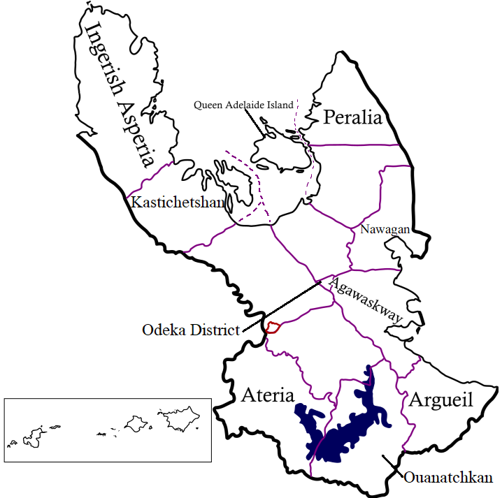 | 718 × 713 (131 KB) | Arlo (talk | contribs) | Added QAI sea border |
| 03:27, 9 March 2023 | Error creating thumbnail: File missing | 718 × 713 (131 KB) | Arlo (talk | contribs) | Added Nawagan | |
| 02:40, 4 March 2023 | Error creating thumbnail: File missing | 713 × 713 (129 KB) | Arlo (talk | contribs) | Updated to reflect new territory names, adding small preview of islands | |
| 15:51, 12 August 2022 | Error creating thumbnail: File missing | 609 × 713 (98 KB) | Intergan (talk | contribs) | Changed misspelling of Argueil | |
| 05:08, 28 July 2022 | Error creating thumbnail: File missing | 609 × 713 (74 KB) | Arlo (talk | contribs) | Self-made using Inkscape, text added. | |
| 04:39, 28 July 2022 | Error creating thumbnail: File missing | 609 × 713 (61 KB) | Arlo (talk | contribs) | Self-made using Inkscape. |
You cannot overwrite this file.
File usage
There are no pages that use this file.