Forum:Territory application/UL03r and Deodeca: Difference between pages
Bixelkoven (talk | contribs) No edit summary |
|||
| Line 1: | Line 1: | ||
{{disambig|the country in Archanta|the [[Collab:Deodeca|collaboration page]]|x}} | |||
{{Infobox country | |||
|coords_zoom = 4 | |||
|coords_lat = -41 | |||
|coords_long = 135.197 | |||
|common_name = Deodeca | |||
|image_flag = 2560px-FP-Deodeca.svg | |||
|national_motto =TBD | |||
|image_map = | |||
|map_caption = | |||
|capital = Stradworth, O.D. | |||
|largest_city = TBD | |||
|official_languages = Ingerish | |||
|regional_languages = Franquese, Native Archantan Languages | |||
|ethnic_groups = | |||
|ethnic_groups_year = | |||
|religion = | |||
|demonym = Deodecan | |||
|government_type = TBD | |||
|leader_title1 =Monarch | |||
|leader_name1 =Geoffrey VII | |||
|leader_title2 =TBD | |||
|leader_name2 =TBD | |||
|leader_title3 =TBD | |||
|leader_name3 =TBD | |||
|legislature = Parliament of Deodeca | |||
|upper_house = Senate | |||
|lower_house = House of Representatives | |||
|area_km2 = 685,572 | |||
|area_sq_mi = 264,701 | |||
|population_census = TBD | |||
|population_census_year = 2019 | |||
|population_density_km2 = | |||
|population_density_sq_mi = | |||
|GDP_PPP = TBD | |||
|GDP_PPP_per_capita = | |||
|HDI = | |||
|HDI_year = 2020 | |||
|HDI_change = {{increase}} | |||
|timezone = WUT+09:00 | |||
|drives_on_the = right | |||
|currency = Deodecan dollar | |||
|currency_code = DCD | |||
|cctld = .dc | |||
|calling_code = | |||
|image_coat=Coat-of-arms Deodeca Edited.svg}} | |||
'''Deodeca''', officially the '''Commonwealth of Deodeca''' is a sovereign country in southern Archanta. It consists of 12 provinces that span 685,000 square kilometres (264,000 square miles), making it one of the largest countries in the world. It borders Ardencia and the FSA to the east and south-east, Ambrosia to the southwest, and AR043 to the west. The capital is TBD, and its largest city is TBD. The [[Ambrosia|Ambrosian]] exclave of {{relation|87788|Upper Crown (Haute Couronne)}} sits between the Deodecan provinces of AR060-3 and AR060-4. Deodeca is a member of the [[Ingerish Commonwealth]], having gained independence from [[Ingerland]] in UNKNOWN YEAR. It is also a member of the [[Assembly of Nations]]. | |||
[[ | |||
==Etymology== | |||
The name "Deodeca" was formed from an anglicisation of the word "Odeka". It was a name used by local tribes to refer to the huge river that orginated inland. | |||
==History== | |||
===Pre-Ulethan History=== | |||
The earliest inhabitants of the Deodecan territory were various Native Archantan (or Native Astrasian) groups that prehistorically migrated from North Archanta. These tribes became culturally and physically distinct from other native tribal groups such as ones located in the Federal States and Ardencia. Among the hundreds of tribes, each developed their own unique internal culture and mythologies. Within Deodeca, there were over TBD major groups that formed rudimentary 'tribal empires'. The Tshayhamhash people of Ingerish Asperia once occupied a large empire that covered the northern portion of Ingerish Asperia. With history being passed down through oral history and art, much of today's knowledge is developed from archaeological findings. | |||
[[File:Indigenous art at the Canadian Museum of History.jpg|250px|thumb|left|An early Indigenous art piece, c. 1450, now located at the National Indigenous Museum in Stradworth. ]] | |||
Native groups have been retrospectively grouped by geographic area to a total of six groupings. '''The North Horn First Nations''' (Ingerish Asperia and Katichtishan), '''Central Prairie First Nations''' (Central Deodeca), '''Northeast First Nations''' (Peralia and part of -11), '''Island First Nations''' (Queen Adelaide Island), '''Lake First Nations''' (Nawagan and Agawaskway) and '''Alpine First Nations''' (Ateria and Ouanatchkan). These groupings refer to individual tribes that shared somewhat common cultural traits with each other. | |||
Native peoples largely lived off the land and commonly hunted bison, deer, rodents, and occasionally birds. Fishing was also very common and Ulethan explorers described very advanced fishing techniques and technologies developed by some tribes. Tribes usually lived along rivers or near water areas. Canoes and boats were constructed using bison or deer hide and were used for transportation and fishing. | |||
There were sometimes conflicts between groups and native oral history describes a particular long and bloody war between TBD and TBD some TBD years ago. Interactions with groups outside of the Deodecan region were rare, mainly due to natural barriers. Some trading was done by lake tribes, as boats allowed for easy access across the lake. The Queen Adelaide Island tribes remained largely isolated from the greater landmass for hundreds of years and developed a distinctly unique cultural and spirituality. | |||
For thousands of years, the indigenous groups occupied the land without any interaction with Ulethan peoples. | |||
===Deodecan Colonies=== | |||
==== Early exploration and colonisation ==== | |||
[[File:Shee - Queen Adelaide - Royal Collection.jpg|200px|thumb|left|Queen Adelaide, painted in TBD by TBD]] | |||
Following a global wave of colonisation by Ulethan powers, Queen Adelaide of Ingerland heard of bountiful lands to the southeast, across the Asperic Ocean. A year earlier, Franquese explorers had reached a previously unknown land, subsequently named Asperia, and set up a rudimentary settlement in present-day Meridien, Ambrosia. Desiring to beat the Franques to the best land, an extensive colonisation and exploratory fleet set sail from Ingerland on TBD. This fleet consisted of 13 ships and was commanded by TBD. The Ingerish planned to head further north than where the Franques landed. This led them to the Sea of Deodeca, where they made landfall at Port Albert, QAI. | |||
The explorers discovered a sheltered harbour and fruitful land. In their report to the Queen, they described a perfect environment for further colonisation. Two years later, an even larger fleet set out, this time intending to develop a more developed and well-supplied post at Hepburn Bay. On arrival, the city of Lamington was proclaimed and is considered the first officiated city in Deodeca. Early life in Lamington was pleasant as the surrounding waters and land allowed for plentiful food and resources. | |||
[[File:Hobart Town, taken from the garden where I lived a3891001h.jpg|300px|thumb|right|Painting of Port Albert in TBD]] | |||
Contact with the TBD tribe just north of Lamington was the first recorded interaction the Ingerish had with the native peoples of Deodeca. The exchange mainly involved the groups watching each other from a distance, seemingly shocked at either's presence. Among the colonists at Lamington was Dr. Thomas Goodhope, a linguist who specialized in non-Ulethan languages. He had previously been part of expeditions exploring Tarephia and some parts of Antarephia. This gave him a well-informed mindset involving indigenous peoples. This became extremely useful during future encounters, where Lamington developed good relations with neighbouring tribes. | |||
Lamington reached a population of 500 residents in TBD. Upon this, the Queen granted the colony governance and in TBD, the colony of Lamington was declared. In TBD, a new settlement was established at Ingerfort. This was the first settlement formed on the continental mainland. Explorers had surveyed the coastline from Westcott all the way to Lamington. Once Queen Adelaide Island was circumnavigated and further towns developed between Lamington and Port Albert, the colony was renamed to Queen Adelaide Island. | |||
In TBD, settlements had been established at New Reydon, Coalburne, and Creswick. This wave of expansion had been fuelled by the extensive migration of Ulethans, driven by the prospects of abundant resources and opportunities in the area. In TBD, The colony of Kastichetshan, Peralia, Clamash, and Ingerish Asperia were proclaimed. The naming of Ingerish Asperia related to a feud between the Ingerish and Franquese powers, both looking to claim most of the Asperia region. | |||
In TBD, explorers undertook a huge overland journey, aiming to survey the interior of the land east of the Great Shield Mountains. This led them to discover Lake Amanceer and Lake Beautouis. Recognising the strategic importance of the location, a settlement named Kingstown (after the then-King TBD), was founded and formed the colony of Agawaskway. | |||
At this point, the largest city was Lamington and served as the unofficial capital and hub of the colonies in the region. Although the colonies were all independent of each other, desires to unite were strong early on. | |||
==== War of Clamash ==== | |||
Castalleanese colonization to the north and proximity to the Deodecan colonies prompted the Ingerish to claim the southernmost of Castallean's claims. This included the port of San Ramon in present day Clamash. The Ingerish blockaded the port, aiming to tire out the settlers without any violence. A Castallean frigate arrived and a standoff ensued. Luckily, no engagement occured and the Ingerish fleet allowed the frigate to pass and transfer the settlers to another Casallenese settlement. This in turn was deemed an Ingerish victory and Clamash was declared a new colony, following the founding of the city of Wahanta along the Henrietta River estuary. As per the Treaty of San Ramon, the Castellan ceded all territory claims in present-day Clamash with the exception of San Ramon. | |||
==== Unionification ==== | |||
===Clamash Purchase=== | |||
Soon after the colonization of Deodeca, Ingerish exploration led them around the Astrasian continent and to the eastern coast. Due to the distance, this area was from most Ulethan powers, it remained largely unexplored and unnoticed. This allowed for the Ingerish to stake their claim without any interference from rival powers. | |||
*INSERT BRIEF FSA HISTORY* | |||
In TBD, The colonies of Deodeca united and the Deodecan Federation was proclaimed. | |||
Due to the rapid industrialization and economic growth of the FSA, pressures within the Province of Clamash grew. Separatist movements grew extremely popular in the 1830s, mainly due to the perceived benefit to the Clamashigan economy by joining the States. In 1842, recognising the value of the province to the Federal States, the FS Congress made an offer of $TBD to purchase the province and allow it to be admitted in the States. The Deodecan parliament accepted the offer and Clamash officially ceded and joined the FSA as a territory. In 1866, The Clamash territory officially became the latest state. After this, the Deodecan constitution was amended to make further secession from the federation extremely difficult. | |||
===Modern History=== | |||
: | ==Geography== | ||
<small>''Main article: [[Geography of Deodeca]]''</small> | |||
< | Deodeca has vast and varied geography that covers a large portion of western Astrasia. Deodeca has extensive maritime borders that extend into the "Sea of Deodeca" and some of the Grand Lakes (Lake Amanecer and Lake Betaouais), giving it a large EEZ. | ||
{{ | |||
===Climate=== | |||
Northern Deodeca sits mainly within the ''Cfa'' and ''Cfb'' climate ranges in the north. These provinces are most susceptible to thunderstorms and strong ocean winds. [[Ingerish Asperia]]'s western coast is most prone to these seaborne storms and breezes due to its position on the Asperic northward current, and is the wettest part of the country. Areas east of (insert name of mountain range), such as eastern Ingerish Asperia and Kastichetshan, receive lower precipitation due to the rain shadow. | |||
As for Southern Deodeca, its distance from the ocean guarantees a mostly continental climate (primarily Dfa and Dfb). However, the number of large lakes allows for a more humid climate in these regions, further enabling the lush temperate to boreal forests that dominate the southern half of the country. Lake-effect snowfall is especially high on eastern shores of Lake Ouanatchkan, as well as in limited amounts along lakes Betaouais and Amanecer. | |||
===Hydrology=== | |||
Deodeca's abundance of water resources is due to its density of water networks. Deodeca has over 200 major rivers. Major rivers include [[Ingerish Asperia]]'s River Agnes and Umbra River, [[Peralia]]'s Jersey River, [[Agawaskway]]'s Frontenac River, Ouanatchkan's Edrange River, and above all, the Odeka River, which flows through the central part of the country. The river is fed by several smaller tributaries and provides water for agriculture, industry, and domestic use. The Odeka River is also an important transportation route, with boats and barges transporting goods and people along its length. | |||
The lakes of Deodeca are an important resource, both economically and environmentally. The largest lake within the country is Lake Ouanatchkan, which is located in the southern part of the country. The lake is fed by several rivers and is an important breeding ground for several species of fish. Lake Betaouais, and Lake Amanecer are among the most important lakes in Deodeca. These contribute to inland Deodeca's moderated climate and provide water resources for humans and the environment. | |||
The wetlands of Deodeca are also vital ecosystems, providing habitat for a variety of plant and animal species. The country's wetlands are home to several species of birds, including herons, egrets, and snipes. The wetlands are also important breeding grounds for several species of fish, and they provide natural water filtration services. | |||
===Biodiversity=== | |||
<gallery> | |||
Mountain Goat Mount Massive.JPG|Liedbeck's mountain goat | |||
Cervus elaphus Luc Viatour 6.jpg|Red deer | |||
Bison in Denton Co., Texas.jpg|Deodecan bison | |||
Altenfelden Chamois Rupicapra rupicapra-2074.jpg|Alpine chamois | |||
African hawk eagle (Aquila spilogaster).jpg|Southern eagle | |||
Perca fluviatilis - Perche commune - European perch Cropped.jpg|Perch | |||
Ardea modesta.jpg|Little egret | |||
Gallinago stenura - Laem Pak Bia.jpg|Bell snipe | |||
</gallery> | |||
The country's varied terrain and climate have contributed to a diverse range of flora and fauna, making it an ideal destination for nature enthusiasts and scientists alike. | |||
The forests of Deodeca are particularly noteworthy, with a mix of deciduous and coniferous trees providing habitat for a wide variety of wildlife. These forests are home to several species of deer, including the red deer and roe deer, as well as predators such as the Astrasian lynx and a small population of grey wolf. In addition, the forests are also home to several species of woodpeckers, owls, and other bird species. Within the prairie and meadows of Deodeca, the iconic Deodecan bison species thrive. The forested areas are also home to pockets of moose. | |||
The alpine regions of Deodeca are characterized by rocky terrain and sparse vegetation, but they are nevertheless home to a number of unique plant and animal species. Liedbeck's mountain goat, which is native to the region, is one of the most iconic animals of Deodeca's alpine regions. Other mammals found in these areas include the ibex and the Alpine chamois. The alpine region is also home to several bird species such as the Southern eagle, the Deodecan hawk, and the snow finch. | |||
[[File:Arctic taiga south of Inuvik, NT.jpg|300px|thumb|right|Typical boreal forest found in southwestern Deodeca]] | |||
Deodeca's rivers and lakes are also important habitats for a variety of aquatic species. The rivers are home to several species of trout, while the lakes are home to various species of freshwater fish such as pike, perch, and carp. The country's wetlands are also important habitats for birds such as the great crested grebe, the little egret, and the Bell snipe. | |||
Despite the rich biodiversity of Deodeca, the country faces several threats to its natural habitats and wildlife. Human activities such as logging, agriculture, and urbanization have contributed to deforestation and habitat loss. Pollution from industries and agriculture has also impacted the water quality of the country's rivers and lakes. | |||
To address these threats, the government of Deodeca has implemented several conservation measures, including protected areas and wildlife reserves. Deodeca has historically been very progressive towards protected areas and most environmental areas are under some form of protection. The country has also signed international agreements to protect its biodiversity, including the Convention on Biological Diversity and the Kingstown Convention on Wetlands. These efforts have helped to protect and preserve Deodeca's unique ecosystems and wildlife for future generations to enjoy. | |||
==Government and Politics== | |||
=== Law === | |||
=== Foreign relations and military === | |||
<small>''Main article: [[Military of Deodeca]]''</small> | |||
===Subdivisions=== | |||
[[File:Deodeca_Provinces.svg|1000px|thumb|left|Map of Deodeca and its provinces.]] | |||
{| class="wikitable sortable mw-collapsible" | |||
|+ Provinces and subdivisions of Deodeca | |||
! Flag !! Name !! Coat of arms !! Code !! Capital City !! Largest City !! Population !! Total Area in km² (mi²) !! Land Area in km² (mi²) !! class="unsortable" | Map | |||
|- | |||
| [[File:Drapeau_Agawaskway.svg|75px]] | |||
| [[Agawaskway]] | |||
| | |||
| AW | |||
| [[Kingstown]] | |||
| [[Kingstown]] | |||
| style="text-align:right;" | 8,500,000 | |||
| style="text-align:right;" | 46,134.08 (17,812.47) | |||
| style="text-align:right;" | 37,726.49 (14,566.28) | |||
| {{Relation|267003|Map}} | |||
|- | |||
| [[File:ArgueilFlag.png|75px]] | |||
| [[Argueil]] | |||
| [[File:ArgueilCoA.png|75px]] | |||
| AG | |||
| [[Liernase]] | |||
| [[Liernase]] | |||
| style="text-align:right;" | | |||
| style="text-align:right;" | 41,977.52 (16207.61) | |||
| style="text-align:right;" | TBD (TBD) | |||
| {{Relation|267004|Map}} | |||
|- | |||
|[[File:Ateria Flag.png|75px]] | |||
| [[Ateria]] | |||
| | |||
| AT | |||
| [[Glenburn]] | |||
| [[Glenburn]] | |||
| style="text-align:right;" | 7,926,000 | |||
| style="text-align:right;" | 56,002.26 (21,622.59) | |||
| style="text-align:right;" | 52,108.68 (21663.68) | |||
| {{Relation|971|Map}} | |||
|- | |||
| [[File:IA_ProvinceFlag.png|75px]] | |||
| [[Ingerish Asperia]] | |||
| [[File:IA CoatOfArms.png|75px]] | |||
| IA | |||
| [[New Reydon]] | |||
| [[Stonesipher]] | |||
| style="text-align:right;" | 10,100,550 | |||
| style="text-align:right;" | 126,605.94 (48,882.83) | |||
| style="text-align:right;" | 99,884.22 (38,565.51) | |||
| {{Relation|949|Map}} | |||
|- | |||
| [[File:FlagKastichetshan.png|75px]] | |||
| [[Kastichetshan]] | |||
| | |||
| KT | |||
| [[Coalburne]] | |||
| [[Coalburne]] | |||
| style="text-align:right;" | 2,464,000 | |||
| style="text-align:right;" | | |||
| style="text-align:right;" | | |||
| {{Relation|267005|Map}} | |||
|- | |||
| [[File:NawaganFlag.jpg|76x76px|alt=|left|frameless]] | |||
| Nawagan | |||
| | |||
| NW | |||
| [[Fayette|Wadeville]] | |||
| [[Fayette]] | |||
| style="text-align:right;" | 5,300,000 | |||
| style="text-align:right;" | Ex | |||
| style="text-align:right;" | Ex | |||
| {{Relation|266998|Map}} | |||
|- | |||
| | |||
| [[Odeka District]] | |||
| | |||
| OD | |||
| [[Stradworth]] | |||
| [[Stradworth]] | |||
| style="text-align:right;" | TBD | |||
| style="text-align:right;" | | |||
| style="text-align:right;" | | |||
| {{Relation|315155|Map}} | |||
|- | |||
| [[File:OuanatchkanFlag.svg|alt=|75x75px]] | |||
| | |||
[[Ouanatchkan]] | |||
| | |||
|OA | |||
|[[TBD]] | |||
|[[Audeville]] | |||
| style="text-align:right;" |3-4 million | |||
| style="text-align:right;" | | |||
| style="text-align:right;" | | |||
|{{Relation|22000|Map}} | |||
|- | |||
| [[File:Peralia_Flag.png|75px]] | |||
|[[Peralia]] | |||
|[[File:Coat_of_Arms_of_Peralia.jpg|75px]] | |||
|PE | |||
|[[Creswick]] | |||
|[[Creswick]] | |||
| style="text-align:right;" |7,228,361 | |||
| style="text-align:right;" |49,330.44 (19,046.59) | |||
| style="text-align:right;" |43,287.75 (16,713.49) | |||
|{{Relation|947|Map}} | |||
|- | |||
| | |||
|[[Queen Adelaide Island]] | |||
| | |||
|QA | |||
|[[Lamington]] | |||
|[[Lamington]] | |||
| style="text-align:right;" |956,000 | |||
| style="text-align:right;" |27,206 (10,504) | |||
| style="text-align:right;" |11,935 (4,608) | |||
|{{Relation|267000|Map}} | |||
|- | |||
| | |||
|Example | |||
| | |||
|Ex | |||
|[[Exampleville]] | |||
|[[Exampleville]] | |||
| style="text-align:right;" | Ex | |||
| style="text-align:right;" | Ex | |||
| style="text-align:right;" |Ex | |||
|{{Relation|Ex|Map}} | |||
|} | |||
==Economy== | |||
===Industries=== | |||
===Science and technology=== | |||
==Demographics== | |||
===Health=== | |||
===Education=== | |||
===Ethnicity=== | |||
===Languages=== | |||
===Religion=== | |||
===Indigenous peoples=== | |||
==Transportation== | |||
===Roadways=== | |||
[[File:TDHprop.svg|200px|thumb|left|Official layout of the Trans Deodecan Highway network. ]] | |||
Deodeca developed a national highway network called the "Trans Deodecan Highway" ('''TDH''') in 19XX to facilitate more efficient travel around the nation. | |||
{| class="wikitable sortable" | |||
|+Trans Deodecan Highway Network | |||
!Name!! Length!!Branches!!Terminus A!!Terminus B!!Provinces !! class="unsortable" |Map | |||
|- | |||
| TDH-1 | |||
|TBD | |||
|1A | |||
|Betoaix, AR | |||
|Stonesipher/Baptist Bay, IA | |||
|AR, AW, -10, -03, KT, IA | |||
|{{Relation|TBD|Map}} | |||
|- | |||
|TDH-2 | |||
|TBD | |||
| None | |||
|Merburra, PE | |||
|Le Pleuta, AT | |||
|PE, -11, -10, -03, -04, AT | |||
|{{Relation|TBD|Map}} | |||
|- | |||
|TDH-3 | |||
|TBD | |||
|None | |||
|Great Shield Pass, KT | |||
|Lamington, QAI | |||
|PE, QAI | |||
|{{Relation|TBD|Map}} | |||
|- | |||
|TDH-4 | |||
| TBD | |||
|4A, 4B | |||
|Attingsford, PE | |||
| Les Prairies d'Edrange, OU | |||
|PE, NA, AW, OU | |||
|{{Relation|TBD|Map}} | |||
|} | |||
===Railways=== | |||
===Maritime=== | |||
==Culture== | |||
=== Symbols=== | |||
<gallery> | |||
8-Point-Star black.svg|The Deodecan eight-point star | |||
American Bison .jpg|Deodecan Bison | |||
ColumbiarivergorgeJRH.jpg|Odeka River | |||
A male moose takes a rest in a field during a light rainshower.jpg|Deodecan Moose | |||
</gallery> | |||
===Literature=== | |||
===Media=== | |||
===Visual arts=== | |||
[https://opengeofiction.net/#map=15/-42.0123/139.8362&layers=B Tawnton Studios] in Port Landley, AG, is one of the most famous film studios in Deodeca and was responsible for many of the early films produced in the country. The adjoining Silentland complex is the location of some of the first films made in Deodeca and Archanta. Nowadays, the studios are still used for major film production, however Silentland has been converted into a tourist attraction. | |||
===Music=== | |||
===Sports=== | |||
==See Also== | |||
*[[Archanta]] | |||
*[[Astrasia]] | |||
*[[Ingerish Commonwealth]] | |||
==Notes== | |||
[[category:Deodeca]] | |||
Revision as of 12:37, 24 March 2023
 This encyclopedia article is about the country in Archanta. You may be looking for the collaboration page.
| Deodeca | |||||
|---|---|---|---|---|---|
| |||||
Loading map... | |||||
| Motto: "TBD" | |||||
| Capital | Stradworth, O.D. | ||||
| Largest city | TBD | ||||
| Official languages | Ingerish | ||||
| • Regional languages | Franquese, Native Archantan Languages | ||||
| Demonym | Deodecan | ||||
| Government | TBD | ||||
| • Monarch | Geoffrey VII | ||||
| • TBD | TBD | ||||
| • TBD | TBD | ||||
| Legislature | Parliament of Deodeca | ||||
| • Upper house | Senate | ||||
| • Lower house | House of Representatives | ||||
| Area | |||||
| • Total | 685,572 km2 264,701 sq mi | ||||
| Population | |||||
| • Census (2019) | TBD | ||||
| GDP (PPP) | |||||
| • Total | TBD | ||||
| Timezone | WUT+09:00 | ||||
| Currency | Deodecan dollar (DCD) | ||||
| Drives on the | right | ||||


Deodeca, officially the Commonwealth of Deodeca is a sovereign country in southern Archanta. It consists of 12 provinces that span 685,000 square kilometres (264,000 square miles), making it one of the largest countries in the world. It borders Ardencia and the FSA to the east and south-east, Ambrosia to the southwest, and AR043 to the west. The capital is TBD, and its largest city is TBD. The Ambrosian exclave of Upper Crown (Haute Couronne)∈⊾ sits between the Deodecan provinces of AR060-3 and AR060-4. Deodeca is a member of the Ingerish Commonwealth, having gained independence from Ingerland in UNKNOWN YEAR. It is also a member of the Assembly of Nations.
Etymology
The name "Deodeca" was formed from an anglicisation of the word "Odeka". It was a name used by local tribes to refer to the huge river that orginated inland.
History
Pre-Ulethan History
The earliest inhabitants of the Deodecan territory were various Native Archantan (or Native Astrasian) groups that prehistorically migrated from North Archanta. These tribes became culturally and physically distinct from other native tribal groups such as ones located in the Federal States and Ardencia. Among the hundreds of tribes, each developed their own unique internal culture and mythologies. Within Deodeca, there were over TBD major groups that formed rudimentary 'tribal empires'. The Tshayhamhash people of Ingerish Asperia once occupied a large empire that covered the northern portion of Ingerish Asperia. With history being passed down through oral history and art, much of today's knowledge is developed from archaeological findings.

Native groups have been retrospectively grouped by geographic area to a total of six groupings. The North Horn First Nations (Ingerish Asperia and Katichtishan), Central Prairie First Nations (Central Deodeca), Northeast First Nations (Peralia and part of -11), Island First Nations (Queen Adelaide Island), Lake First Nations (Nawagan and Agawaskway) and Alpine First Nations (Ateria and Ouanatchkan). These groupings refer to individual tribes that shared somewhat common cultural traits with each other.
Native peoples largely lived off the land and commonly hunted bison, deer, rodents, and occasionally birds. Fishing was also very common and Ulethan explorers described very advanced fishing techniques and technologies developed by some tribes. Tribes usually lived along rivers or near water areas. Canoes and boats were constructed using bison or deer hide and were used for transportation and fishing.
There were sometimes conflicts between groups and native oral history describes a particular long and bloody war between TBD and TBD some TBD years ago. Interactions with groups outside of the Deodecan region were rare, mainly due to natural barriers. Some trading was done by lake tribes, as boats allowed for easy access across the lake. The Queen Adelaide Island tribes remained largely isolated from the greater landmass for hundreds of years and developed a distinctly unique cultural and spirituality.
For thousands of years, the indigenous groups occupied the land without any interaction with Ulethan peoples.
Deodecan Colonies
Early exploration and colonisation

Following a global wave of colonisation by Ulethan powers, Queen Adelaide of Ingerland heard of bountiful lands to the southeast, across the Asperic Ocean. A year earlier, Franquese explorers had reached a previously unknown land, subsequently named Asperia, and set up a rudimentary settlement in present-day Meridien, Ambrosia. Desiring to beat the Franques to the best land, an extensive colonisation and exploratory fleet set sail from Ingerland on TBD. This fleet consisted of 13 ships and was commanded by TBD. The Ingerish planned to head further north than where the Franques landed. This led them to the Sea of Deodeca, where they made landfall at Port Albert, QAI.
The explorers discovered a sheltered harbour and fruitful land. In their report to the Queen, they described a perfect environment for further colonisation. Two years later, an even larger fleet set out, this time intending to develop a more developed and well-supplied post at Hepburn Bay. On arrival, the city of Lamington was proclaimed and is considered the first officiated city in Deodeca. Early life in Lamington was pleasant as the surrounding waters and land allowed for plentiful food and resources.

Contact with the TBD tribe just north of Lamington was the first recorded interaction the Ingerish had with the native peoples of Deodeca. The exchange mainly involved the groups watching each other from a distance, seemingly shocked at either's presence. Among the colonists at Lamington was Dr. Thomas Goodhope, a linguist who specialized in non-Ulethan languages. He had previously been part of expeditions exploring Tarephia and some parts of Antarephia. This gave him a well-informed mindset involving indigenous peoples. This became extremely useful during future encounters, where Lamington developed good relations with neighbouring tribes.
Lamington reached a population of 500 residents in TBD. Upon this, the Queen granted the colony governance and in TBD, the colony of Lamington was declared. In TBD, a new settlement was established at Ingerfort. This was the first settlement formed on the continental mainland. Explorers had surveyed the coastline from Westcott all the way to Lamington. Once Queen Adelaide Island was circumnavigated and further towns developed between Lamington and Port Albert, the colony was renamed to Queen Adelaide Island.
In TBD, settlements had been established at New Reydon, Coalburne, and Creswick. This wave of expansion had been fuelled by the extensive migration of Ulethans, driven by the prospects of abundant resources and opportunities in the area. In TBD, The colony of Kastichetshan, Peralia, Clamash, and Ingerish Asperia were proclaimed. The naming of Ingerish Asperia related to a feud between the Ingerish and Franquese powers, both looking to claim most of the Asperia region.
In TBD, explorers undertook a huge overland journey, aiming to survey the interior of the land east of the Great Shield Mountains. This led them to discover Lake Amanceer and Lake Beautouis. Recognising the strategic importance of the location, a settlement named Kingstown (after the then-King TBD), was founded and formed the colony of Agawaskway.
At this point, the largest city was Lamington and served as the unofficial capital and hub of the colonies in the region. Although the colonies were all independent of each other, desires to unite were strong early on.
War of Clamash
Castalleanese colonization to the north and proximity to the Deodecan colonies prompted the Ingerish to claim the southernmost of Castallean's claims. This included the port of San Ramon in present day Clamash. The Ingerish blockaded the port, aiming to tire out the settlers without any violence. A Castallean frigate arrived and a standoff ensued. Luckily, no engagement occured and the Ingerish fleet allowed the frigate to pass and transfer the settlers to another Casallenese settlement. This in turn was deemed an Ingerish victory and Clamash was declared a new colony, following the founding of the city of Wahanta along the Henrietta River estuary. As per the Treaty of San Ramon, the Castellan ceded all territory claims in present-day Clamash with the exception of San Ramon.
Unionification
Clamash Purchase
Soon after the colonization of Deodeca, Ingerish exploration led them around the Astrasian continent and to the eastern coast. Due to the distance, this area was from most Ulethan powers, it remained largely unexplored and unnoticed. This allowed for the Ingerish to stake their claim without any interference from rival powers.
- INSERT BRIEF FSA HISTORY*
In TBD, The colonies of Deodeca united and the Deodecan Federation was proclaimed.
Due to the rapid industrialization and economic growth of the FSA, pressures within the Province of Clamash grew. Separatist movements grew extremely popular in the 1830s, mainly due to the perceived benefit to the Clamashigan economy by joining the States. In 1842, recognising the value of the province to the Federal States, the FS Congress made an offer of $TBD to purchase the province and allow it to be admitted in the States. The Deodecan parliament accepted the offer and Clamash officially ceded and joined the FSA as a territory. In 1866, The Clamash territory officially became the latest state. After this, the Deodecan constitution was amended to make further secession from the federation extremely difficult.
Modern History
Geography
Main article: Geography of Deodeca
Deodeca has vast and varied geography that covers a large portion of western Astrasia. Deodeca has extensive maritime borders that extend into the "Sea of Deodeca" and some of the Grand Lakes (Lake Amanecer and Lake Betaouais), giving it a large EEZ.
Climate
Northern Deodeca sits mainly within the Cfa and Cfb climate ranges in the north. These provinces are most susceptible to thunderstorms and strong ocean winds. Ingerish Asperia's western coast is most prone to these seaborne storms and breezes due to its position on the Asperic northward current, and is the wettest part of the country. Areas east of (insert name of mountain range), such as eastern Ingerish Asperia and Kastichetshan, receive lower precipitation due to the rain shadow.
As for Southern Deodeca, its distance from the ocean guarantees a mostly continental climate (primarily Dfa and Dfb). However, the number of large lakes allows for a more humid climate in these regions, further enabling the lush temperate to boreal forests that dominate the southern half of the country. Lake-effect snowfall is especially high on eastern shores of Lake Ouanatchkan, as well as in limited amounts along lakes Betaouais and Amanecer.
Hydrology
Deodeca's abundance of water resources is due to its density of water networks. Deodeca has over 200 major rivers. Major rivers include Ingerish Asperia's River Agnes and Umbra River, Peralia's Jersey River, Agawaskway's Frontenac River, Ouanatchkan's Edrange River, and above all, the Odeka River, which flows through the central part of the country. The river is fed by several smaller tributaries and provides water for agriculture, industry, and domestic use. The Odeka River is also an important transportation route, with boats and barges transporting goods and people along its length.
The lakes of Deodeca are an important resource, both economically and environmentally. The largest lake within the country is Lake Ouanatchkan, which is located in the southern part of the country. The lake is fed by several rivers and is an important breeding ground for several species of fish. Lake Betaouais, and Lake Amanecer are among the most important lakes in Deodeca. These contribute to inland Deodeca's moderated climate and provide water resources for humans and the environment.
The wetlands of Deodeca are also vital ecosystems, providing habitat for a variety of plant and animal species. The country's wetlands are home to several species of birds, including herons, egrets, and snipes. The wetlands are also important breeding grounds for several species of fish, and they provide natural water filtration services.
Biodiversity

Liedbeck's mountain goat

Red deer
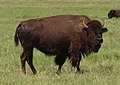
Deodecan bison

Alpine chamois

Southern eagle

Perch
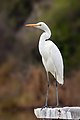
Little egret

Bell snipe


.jpg)


The country's varied terrain and climate have contributed to a diverse range of flora and fauna, making it an ideal destination for nature enthusiasts and scientists alike.
The forests of Deodeca are particularly noteworthy, with a mix of deciduous and coniferous trees providing habitat for a wide variety of wildlife. These forests are home to several species of deer, including the red deer and roe deer, as well as predators such as the Astrasian lynx and a small population of grey wolf. In addition, the forests are also home to several species of woodpeckers, owls, and other bird species. Within the prairie and meadows of Deodeca, the iconic Deodecan bison species thrive. The forested areas are also home to pockets of moose.
The alpine regions of Deodeca are characterized by rocky terrain and sparse vegetation, but they are nevertheless home to a number of unique plant and animal species. Liedbeck's mountain goat, which is native to the region, is one of the most iconic animals of Deodeca's alpine regions. Other mammals found in these areas include the ibex and the Alpine chamois. The alpine region is also home to several bird species such as the Southern eagle, the Deodecan hawk, and the snow finch.

Deodeca's rivers and lakes are also important habitats for a variety of aquatic species. The rivers are home to several species of trout, while the lakes are home to various species of freshwater fish such as pike, perch, and carp. The country's wetlands are also important habitats for birds such as the great crested grebe, the little egret, and the Bell snipe.
Despite the rich biodiversity of Deodeca, the country faces several threats to its natural habitats and wildlife. Human activities such as logging, agriculture, and urbanization have contributed to deforestation and habitat loss. Pollution from industries and agriculture has also impacted the water quality of the country's rivers and lakes.
To address these threats, the government of Deodeca has implemented several conservation measures, including protected areas and wildlife reserves. Deodeca has historically been very progressive towards protected areas and most environmental areas are under some form of protection. The country has also signed international agreements to protect its biodiversity, including the Convention on Biological Diversity and the Kingstown Convention on Wetlands. These efforts have helped to protect and preserve Deodeca's unique ecosystems and wildlife for future generations to enjoy.
Government and Politics
Law
Foreign relations and military
Main article: Military of Deodeca
Subdivisions

| Flag | Name | Coat of arms | Code | Capital City | Largest City | Population | Total Area in km² (mi²) | Land Area in km² (mi²) | Map |
|---|---|---|---|---|---|---|---|---|---|
| Agawaskway | AW | Kingstown | Kingstown | 8,500,000 | 46,134.08 (17,812.47) | 37,726.49 (14,566.28) | Map∈⊾ | ||
| Argueil | 
|
AG | Liernase | Liernase | 41,977.52 (16207.61) | TBD (TBD) | Map∈⊾ | ||
| Ateria | AT | Glenburn | Glenburn | 7,926,000 | 56,002.26 (21,622.59) | 52,108.68 (21663.68) | Map∈⊾ | ||
| Ingerish Asperia | 
|
IA | New Reydon | Stonesipher | 10,100,550 | 126,605.94 (48,882.83) | 99,884.22 (38,565.51) | Map∈⊾ | |
| Kastichetshan | KT | Coalburne | Coalburne | 2,464,000 | Map∈⊾ | ||||
| Nawagan | NW | Wadeville | Fayette | 5,300,000 | Ex | Ex | Map∈⊾ | ||
| Odeka District | OD | Stradworth | Stradworth | TBD | Map∈⊾ | ||||
| OA | TBD | Audeville | 3-4 million | Map∈⊾ | |||||
| Peralia | 
|
PE | Creswick | Creswick | 7,228,361 | 49,330.44 (19,046.59) | 43,287.75 (16,713.49) | Map∈⊾ | |
| Queen Adelaide Island | QA | Lamington | Lamington | 956,000 | 27,206 (10,504) | 11,935 (4,608) | Map∈⊾ | ||
| Example | Ex | Exampleville | Exampleville | Ex | Ex | Ex | Map∈⊾ |
Economy
Industries
Science and technology
Demographics
Health
Education
Ethnicity
Languages
Religion
Indigenous peoples
Transportation
Roadways

Deodeca developed a national highway network called the "Trans Deodecan Highway" (TDH) in 19XX to facilitate more efficient travel around the nation.
| Name | Length | Branches | Terminus A | Terminus B | Provinces | Map |
|---|---|---|---|---|---|---|
| TDH-1 | TBD | 1A | Betoaix, AR | Stonesipher/Baptist Bay, IA | AR, AW, -10, -03, KT, IA | Map∈⊾ |
| TDH-2 | TBD | None | Merburra, PE | Le Pleuta, AT | PE, -11, -10, -03, -04, AT | Map∈⊾ |
| TDH-3 | TBD | None | Great Shield Pass, KT | Lamington, QAI | PE, QAI | Map∈⊾ |
| TDH-4 | TBD | 4A, 4B | Attingsford, PE | Les Prairies d'Edrange, OU | PE, NA, AW, OU | Map∈⊾ |
Railways
Maritime
Culture
Symbols

The Deodecan eight-point star

Deodecan Bison

Odeka River

Deodecan Moose


Literature
Media
Visual arts
Tawnton Studios in Port Landley, AG, is one of the most famous film studios in Deodeca and was responsible for many of the early films produced in the country. The adjoining Silentland complex is the location of some of the first films made in Deodeca and Archanta. Nowadays, the studios are still used for major film production, however Silentland has been converted into a tourist attraction.