Collab:Federal States/Collaborative States/New Carnaby
| This page is open to discuss collaboration aspects for New Carnaby. It is a work in progress. |
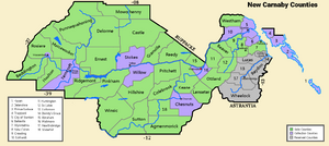
New Carnaby is a collaborative project within the FSA. Anyone interested in participating is free to take up a county or project by contacting Fluffr_Nuttr.
Coordination
This project is coordinated by Fluffr_Nuttr and Easky30.
Background
New Carnaby has a population of 17.6 Million and is inspired by New York and the American Northeast. Like New York, there is a stark contrast between the dense Stanton-Warwick metro and the largely rural interior.
Metro Stanton-Warwick is one of the FSA’s main metropolises, centered at the mouth of the Carnaby River (along with Warwick Island in Penquisset). Its sprawl extends down the Carnaby Valley, along the Stanton Bay and along a line to Sadikady. A few larger cities exist to the south, which became fundamentally tied to Stanton in the 20th century. Stanton itself is influenced by NYC and other northeastern cities, and the suburbia draws from the lower Hudson Valley, New Jersey and Connecticut.
The Carnaby River, which is naturally navigable as far as Yallop, has long formed an important corridor for trade. Over a period of 30 years after independence, an ambitious canal was constructed to allow ships to travel from Stanton to Lake Leighton. The canal, and later the railroads, encouraged the growth of Stanton, Waltmore, Yallop, Three Rivers, and several smaller towns along the river.
Also of note are:
- The parallel mountain ranges which give much of the state a rural character
- The Delenshire Islands, divided between dense Stanton suburbia and rich vacation towns
- The Scantuck Valley, strongly influenced by the Puritan/Congressionalist dissidents who settled there
Collaborative Framework
Stanton
Instead of being divided into boroughs, Stanton is a consolidated city-county made up of 11 wards, each with several hundred thousand people and subdivided into many neighborhoods. They are not meant to be claimed individually- anyone can map throughout the city as long as they have permission (either message Fluffr_Nuttr or discuss on the talk page). But the themes of the wards can give mappers an idea of where to create what they wish. This also gives Stanton a slightly different identity than our NYC.
- Stanton’s downtown is wealthy, though as more people work than live there, things get pretty quiet at night. Inspired heavily by Lower Manhattan, with some cues from Philadelphia.
- Northern Stanton is somewhat of an industrial remnant, containing a large port facility and one of Stanton’s older airports.
- South Carnaby (or SoCar) would be more of a hipster neighborhood, probably recently gentrified, while Brownstone has some gentrification and some old money.
- Weybirton, St. Cassian, Goose Bay and Southside would have both working-class areas and projects, some attempts at developing villages within the city, and some middle-class areas.
- West Warwick is the transition area between Stanton and Warwick, possibly reflecting Northern Queens and Nassau County.
- The western wards will likely be more industrial and working-class, especially Astera, Perister, and Kenver. Hudson County, New Jersey could be a great source of inspiration.
List of county-mappers
Error while fetching data from URL https://osm3s.opengeofiction.net/api/interpreter?data=(area[name="New%20Carnaby"];%20)->.a;%20rel["admin_level"="6"][name](area.a);(._;>;);out;: $2.
Error fetching URL: Could not resolve host: osm3s.opengeofiction.net
There was a problem during the HTTP request: 0 Error
Could not get URL https://osm3s.opengeofiction.net/api/interpreter?data=(area[name="New%20Carnaby"];%20)->.a;%20rel["admin_level"="6"][name](area.a);(._;>;);out; after 3 tries.
| Link | Name | Type | Reference | Relation ID | Owner |
|---|
| Collaborative Projects | States: Territories: Protectorates: |
|---|---|
| Natural Environment | National Parks • Natural features |
| Commerce | Franchises • Industries |
| Infrastructure | Government • Military • Transportation |
| Worldbuilding | History • Important persons • International relations • Non-governmental organizations • Sports • State profiles |
| Project Communication | Main project page • Discord (request access) • Federal States Forum (archive) • Newcomers Guide • Archives |

