Search results

File:OGFatR Place.png OpenGeofiction represented at [https://www.reddit.com/r/place?utm_medium=android_app&utm_s Picture includes the flag of [[Navenna]] (by [[User:Timboh]]) and the OpenGeofiction logo.(1,375 × 745 (309 KB)) - 00:22, 5 April 2022
File:Ingerland Capital Old Town - sudo91.png Made by sudo91. Software used: paint.net/JOSM. Base layer: OpenGeofiction tilemap.(1,319 × 863 (248 KB)) - 08:56, 17 May 2024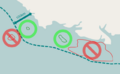
File:Islandguidelines02.png Illustration for [[OpenGeofiction:Rules of the sea]], original by [[User:Isleño]](640 × 396 (47 KB)) - 12:28, 16 March 2022
File:Islandguidelines03.gif Illustration for [[OpenGeofiction:Rules of the sea]], original by [[User:Isleño]](640 × 396 (60 KB)) - 12:28, 16 March 2022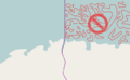
File:Islandguidelines04.png Illustration for [[OpenGeofiction:Rules of the sea]], original by [[User:Isleño]](640 × 396 (58 KB)) - 12:29, 16 March 2022
File:Islandguidelines05.png Illustration for [[OpenGeofiction:Rules of the sea]], original by [[User:Isleño]](640 × 396 (40 KB)) - 12:29, 16 March 2022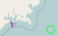
File:Seaborderguidelines01.png Illustration for [[OpenGeofiction:Rules of the sea]], original by [[User:Isleño]](640 × 396 (28 KB)) - 12:05, 16 March 2022
File:Islandguidelines06.png Illustration for [[OpenGeofiction:Rules of the sea]], original by [[User:Isleño]](640 × 396 (28 KB)) - 12:29, 16 March 2022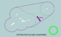
File:Seaborderguidelines02.png Illustration for [[OpenGeofiction:Rules of the sea]], original by [[User:Isleño]](640 × 396 (41 KB)) - 12:06, 16 March 2022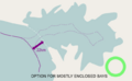
File:Seaborderguidelines03.png Illustration for [[OpenGeofiction:Rules of the sea]], original by [[User:Isleño]](640 × 396 (40 KB)) - 12:06, 16 March 2022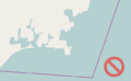
File:Seaborderguidelines04.png Illustration for [[OpenGeofiction:Rules of the sea]], original by [[User:Isleño]](640 × 396 (23 KB)) - 12:07, 16 March 2022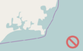
File:Seaborderguidelines05.png Illustration for [[OpenGeofiction:Rules of the sea]], original by [[User:Isleño]](640 × 396 (23 KB)) - 12:07, 16 March 2022
File:Seaborderguidelines06.png Illustration for [[OpenGeofiction:Rules of the sea]], original by [[User:Isleño]](640 × 396 (29 KB)) - 12:08, 16 March 2022
File:Islandguidelines01.png Illustration for [[OpenGeofiction:Rules of the sea]], original by [[User:Isleño]](640 × 396 (111 KB)) - 12:28, 16 March 2022
File:DE-15 Roads Application.png Original creation. Base map is taken from OpenGeofiction. Additions made in paint.net.(1,463 × 1,080 (551 KB)) - 13:15, 25 December 2023
File:DE-15 Capital Application.png Original creation. The base map is taken from OpenGeofiction tilemap layer. Additions made in paint.net.(1,135 × 904 (58 KB)) - 13:15, 25 December 2023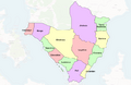
File:FreedemiaStateMap.png Freedemia's 13 states. My own work in Affinity Designer overlaid over the OpenGeofiction Map.(1,303 × 846 (299 KB)) - 10:53, 7 July 2022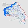
File:DE-15 Application Update20231224.png ...d {{OGF user|Lithium-Ion}}. Re-drawn by sudo91. Original map is taken from OpenGeofiction.(1,085 × 1,080 (28 KB)) - 13:22, 25 December 2023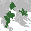
File:ASUN map.svg ...of Wikipedia's green maps. Country shapes derived from imported data from OpenGeofiction.(512 × 503 (113 KB)) - 17:23, 12 January 2023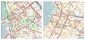
File:City-tutorial-honolulu-leluwa.jpg For use in realistic cities tutorial. Images from OpenGeofiction and openstreetmap.org, licensed under the Open Data Commons Open Database L(800 × 375 (148 KB)) - 23:36, 17 October 2021


