Forum:Global and regional issues/Uletha - Continental Road Numbering System
Topic
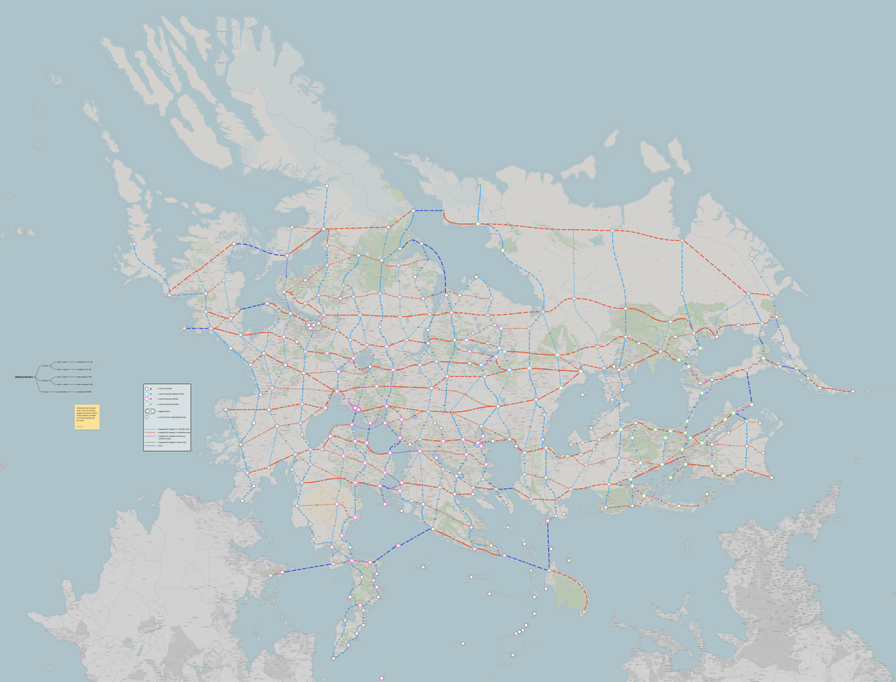
Similar to the European E-roads and Asian Highways networks, a continental network within (West) Uletha can be developed in the same fashion, designating existing mapped motorways and national roads as part of a numbering scheme, as well as attempting to create a coherent network of roads between territories, enhancing collaboration between users. The concept is simple, designate control cities as checkpoints and connect them as part of a very loose grid network of roads. Each territory will be represented by at least one control city, and users themselves will decide where exactly will the route be located within their own territory, as long as it connects to the other control cities.
The goal is not to force users to map roads as told, the idea is based on numbering existing roads, not necessarily creating new connections (although users are free to do that as well). The idea is non-binding, meaning users do not have to follow the system if they do not want to, alike certain countries in the real world (such as the United Kingdom and Albania). Users are also free to suggest alternatives to the proposal.
The idea was coined and the proposal developed by users Timboh and Bixelkoven, who originally intended on developing a system that would be used within ASUN and wanted to spread the idea across the continent. The proposal does not define the template of the numbers, such as the E- prefix in the European equivalent. The simplest idea is to use the prefix U (which stands for Uletha), for example U10 . Some other ideas for the prefix, if any, include:
- U roads (U-10, U·10...)
- UL roads (UL10, UL-10, UL·10...)
- UH roads (UH10, UH-10, UH·10...)
The image of the proposal can be found at the following link, hosted externally due to the large size of the file.
In the Discussion tab below, users are welcome to suggest alternative routes, propose different ideas to the concept as a whole, suggest control cities, or in general discuss whether this proposal/system is a good or bad idea.
How is it mapped?
Road numbers are tagged with the ref=* tag, both on OpenStreetMap and OpenGeofiction. The European E-routes are tagged on OpenStreetMap using the int_ref=* tag which does not render on the standard Carto map style. Countries such as Sweden and Belgium, which solely use this system for some of their road networks utilize the ref=* tag, which does render. Some custom renderers do render the int_ref=* tagged values.
On OGF, the simplest way to render the road number would be to utilize the ref=* tag, for example ref=U10. However, given that by default countries have their own numbering systems, the solution would be to tag both numbers under the same tag, separated by semicolons. Example: ref=A3;U10 or ref=57;UL-87, rendering one number below the other. External (off-site) renderers may offer the alternative to separate the two different systems, but this forum post concerns only the standard Carto map style used on OGF.
Additionally, routes are tagged as relations with the roads as the relation members. It is not imperative to create a relation, using only the ref=* tag is enough. Here's an example on how a E route is tagged on OpenStreetMap: E 75 in Finland. As part of the relation, the network=U-road (for example) tag designates the road system which the road is part of.
Discussion
If you have comments regarding this topic, please add them here. ── Bixelkoven (talk) (West Uletha Admin) 19:06, 22 December 2025 (UTC)
Hello everyone, I have to comments I would like to make. The first is that I wonder whether East and West Uletha are aligned closely enough, politically, to make a uniform road nomenclature across the continent realistic. It would be similar to having a Eurasian road numbering scheme as opposed to the two examples Bixel gives in the introduction. Maybe this is a topic for the EUOIA etc.? And secondly, on the road network itself, it seems very focussed on my eyes on east-west and north-south directionality, similar to the US interstate system. This is a valid approach, but have you also considered a more strategic, corridor-focussed approach, maybe more similar to the European TEN-T corridors? They are drawn so that major economic regions are connected which leads to some corridors not being strictly north-south or east-west. Just a thought I want to throw out there, I also see the appeal in the presented approach. Best, and merry Christmas to the eastern Hemisphere already! Leowezy (talk) 11:06, 23 December 2025 (UTC)
- As someone who only map in West Uletha, I personally do not feel strongly about whether East Uletha is included in the system or not. The proposal was created with route numbers reserved for East Uletha in case that the territories of East Uletha would want to be included. If we were to implement the system only in West Uletha, it might be wise to reserve the East Ulethan route numbers just in case. West and East Uletha do share a long land border, but to what degree long-distance road travel occurs between these two regions depends on the political and economic relations between territories along the border. As for who implemented the system, it could either have been agreed upon top-down, for example through an AN treaty much like the real life UNECE, or it could have begun as a regional initiative, such as an ASUN or EUOIA treaty that over time expanded in scope to eventually include much of the continent. As for the second point, we have experimented with proposals for a pan-Ulethan route network based on strategic corridors in the past. In theory it is an excellent idea - basing the network on actual expected functional spatial relationships between nodes would give us a more efficient network. This previous proposal never got any traction unfortunately. The main obstacles with this approach is that defining strategic corridors requires much more in-depth knowledge about the geography, economic structure och functional flows of each and every territory. Since the world of OGF is ever changing, with territories switching ownership and changing their general character regularly, this would necessitate reworking these strategic corridors very often to make sure they still "make sense". I believe that this proposal, which takes heavy inspiration from the way the international E-route network defines routes (E-routes primarliy follow cardinal directions), is more suitable given how the world of OGF is managed. Here we only need control cities, which we can safely assume there will be at least one of in every territory. Our proposal allows for C-class (triple-digit) routes that do not follow any cardinal direction. If a single mapper or a group of mappers identify an important link not covered by the A- or B-class U-network, they can create their own C-class route on their own initiative. The final proposal should probably include a recommendation for how to select a suitable reference number for these C-class routes. Timboh (talk) 17:18, 23 December 2025 (UTC)