OpenGeofiction:Rules of the sea: Difference between revisions
(Importing) |
m (summary) |
||
| (One intermediate revision by the same user not shown) | |||
| Line 1: | Line 1: | ||
OpenGeofiction has '''rules for coastal borders and the creation of islands''', without these our world would quickly become chaotic and crowded. | |||
==Rules for sea borders== | == Rules for sea borders == | ||
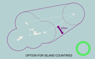
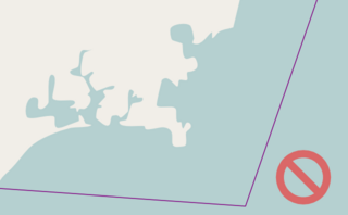
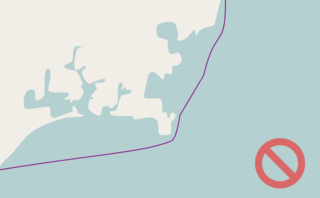
{| | Sea borders should be drawn '''22 km from the shore'''. Note the optional exceptions for island nations, and for bays which are mostly enclosed. (See also: [https://opengeofiction.net/user/Easky30/diary/22 How to create sea borders]) | ||
{| | |||
|- | |- | ||
| [[File:Seaborderguidelines01.png|320px|thumb|Draw 22km from shoreline]] || [[File:Seaborderguidelines02.png|320px|thumb|Baseline for island territories]] || [[File:Seaborderguidelines03.png|320px|thumb|Enclosed inland water]] | |||
|- | |- | ||
| [[File:Seaborderguidelines04.png|320px|thumb|No arbitrary border]] || [[File:Seaborderguidelines05.png|320px|thumb|Not just a baseline]] || [[File:Seaborderguidelines06.png|320px|thumb|Sea border must take into account islands]] | |||
|} | |} | ||
==Rules for island building== | == Rules for island building == | ||
{| | {| | ||
|- | |- | ||
| OGF has some rules for creating coastal and oceanic islands. | |||
Without these rules, our world would eventually get pretty crowded... | |||
Without these rules, our world would eventually get pretty crowded... | | [[File:Islandguidelines01.png|320px|thumb|Avoiding chaos]] | ||
|- | |- | ||
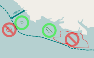
| | | Therefore user-created islands should respect two basic principles: | ||
# Islands should be '''within 100 km of your mainland coastline''', and | |||
''' | # Islands should be '''reasonably small''' (use your judgement). | ||
''' | |||
Of course larger islands and more distant islands do exist in OGF, but in order to control their number they are normally created by the admin team only. | Of course larger islands and more distant islands do exist in OGF, but in order to control their number they are normally created by the admin team only. | ||
| [[File:Islandguidelines02.png|320px|thumb|Within 100km and reasonably small]] | |||
|- | |- | ||
| If you add islands, remember to adjust your 22 km maritime boundary | |||
| | | [[File:Islandguidelines03.gif|320px|thumb|Adjust the sea border]] | ||
|- | |||
| Coordinate with your neighbors to create a natural looking environment across borders. | |||
Study real world maps to mimic islands realistically. | Study real world maps to mimic islands realistically. | ||
| | | [[File:Islandguidelines04.png|320px|thumb|Coordination is important]] | ||
|- | |||
| Please create your own original islands, instead of copying land from Earth | |||
| [[File:Islandguidelines05.png|320px|thumb|Do not copy]] | |||
|- | |- | ||
| | | If you are developing an island country, please do not "fatten" your island to gain more land area. | ||
If you would like more territory, then please contact admin to select a bigger territory. | |||
| [[File:Islandguidelines06.png|320px|thumb|Do not fatten]] | |||
|} | |} | ||
==Rules for | == Rules for ferry lines == | ||
{| | Ferry routes should be mapped following {{OSMW|Tag:route%3Dferry|OpenStreetMap guidelines}}. Historically, shipping routes were also mapped in OGF, however this is no longer supported. | ||
==See also== | == See also == | ||
For information about sea boundaries in the real world: [https://en.wikipedia.org/wiki/Territorial_waters Territorial waters] | For information about sea boundaries in the real world: [https://en.wikipedia.org/wiki/Territorial_waters Territorial waters] | ||
Latest revision as of 13:13, 16 March 2022
OpenGeofiction has rules for coastal borders and the creation of islands, without these our world would quickly become chaotic and crowded.
Rules for sea borders
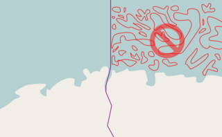
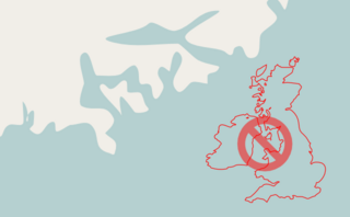
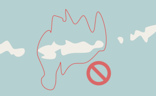
Sea borders should be drawn 22 km from the shore. Note the optional exceptions for island nations, and for bays which are mostly enclosed. (See also: How to create sea borders)
Rules for island building
| OGF has some rules for creating coastal and oceanic islands.
Without these rules, our world would eventually get pretty crowded... |
|
Therefore user-created islands should respect two basic principles:
Of course larger islands and more distant islands do exist in OGF, but in order to control their number they are normally created by the admin team only. |
|
| If you add islands, remember to adjust your 22 km maritime boundary | |
| Coordinate with your neighbors to create a natural looking environment across borders.
Study real world maps to mimic islands realistically. |
|
| Please create your own original islands, instead of copying land from Earth | |
| If you are developing an island country, please do not "fatten" your island to gain more land area.
If you would like more territory, then please contact admin to select a bigger territory. |
Rules for ferry lines
Ferry routes should be mapped following ![]() OpenStreetMap guidelines. Historically, shipping routes were also mapped in OGF, however this is no longer supported.
OpenStreetMap guidelines. Historically, shipping routes were also mapped in OGF, however this is no longer supported.
See also
For information about sea boundaries in the real world: Territorial waters

