Search results
Page title matches
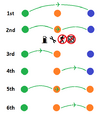
File:OGF Air Freedoms.png Graphical reference of OGF's six air freedoms, from the perspective of the orange nation. Gas pump and(494 × 575 (12 KB)) - 21:49, 19 August 2022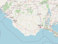
File:OGF - UL08g - Plan.png {{cc-ogf-map}}(980 × 745 (500 KB)) - 12:56, 2 March 2024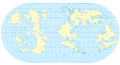
File:Ogf base world map.svg Blank map of the OGF world landmasses, with latitude and longitude lines every 15 degrees over t {{Cc-ogf-map}}(1,020 × 549 (1.67 MB)) - 22:59, 24 April 2024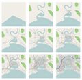
File:City-tutorial-ogf-city-evolution.jpg (800 × 782 (136 KB)) - 23:35, 17 October 2021


Page text matches
File:DE-15 Application Update20231224.png Based on the works of {{OGF user|Arlo}} and {{OGF user|Lithium-Ion}}. Re-drawn by sudo91. Original map is taken from OpenGeof {{cc-ogf-map}}(1,085 × 1,080 (28 KB)) - 13:22, 25 December 2023
File:Pax Nova logo.png ...ork by {{OGF user|Pawl}}, based on the design of {{OGF user|isleño}} and {{OGF user|Luciano}}.(1,200 × 985 (62 KB)) - 21:47, 29 August 2022
File:Bai influences regional map.png Screenshot from OGF, edited through Paint. {{Cc-ogf-map}}(901 × 753 (736 KB)) - 01:30, 13 February 2024
File:Coastline density UL 2024-02-04.png Illustration of OGF coastline node density {{Cc-ogf-map}}(2,825 × 1,635 (1.21 MB)) - 22:54, 4 February 2024
File:Northeastern FSA motorways 4.png OGF Screenshot, edited in paint.net {{Cc-ogf-map}}(1,207 × 811 (755 KB)) - 20:20, 14 April 2024
File:Marker-airport2a.png Originally created by {{OGF user|mstr}} for the OGF project.(25 × 25 (1 KB)) - 09:26, 25 November 2021
File:Northeastern FSA motorways 3.png OGF Screenshot, edited in paint.net {{Cc-ogf-map}}(1,207 × 811 (759 KB)) - 02:42, 14 March 2024
File:WM Shield revised.svg ...user|TheMayor}} that itself is derived from an outline of the state on the OGF map. {{Cc-ogf-map}}(240 × 240 (4 KB)) - 04:53, 30 January 2024
File:Emb-green.png Originally created by {{OGF user|isleño}} for the OGF project.(50 × 50 (4 KB)) - 21:19, 5 September 2021
File:Emb-yellow.png Originally created by {{OGF user|isleño}} for the OGF project.(50 × 50 (5 KB)) - 21:19, 5 September 2021
File:Emb-red.png Originally created by {{OGF user|isleño}} for the OGF project.(50 × 50 (4 KB)) - 03:15, 6 September 2021
File:Basse Ambroisie.jpg Originally created by {{OGF user|Newflanders}} {{cc-ogf-flag}}(465 × 274 (22 KB)) - 12:55, 26 March 2022
File:Haute Ambroisie.jpg Originally created by {{OGF user|Newflanders}} {{cc-ogf-flag}}(465 × 274 (27 KB)) - 12:55, 26 March 2022
File:Galésie.jpg Originally created by {{OGF user|Newflanders}} {{cc-ogf-flag}}(465 × 274 (28 KB)) - 12:56, 26 March 2022
File:Lithium-Castellan-Coast-Plan.png OGF Map, additions drawn by me. {{Cc-ogf-map}}(1,100 × 938 (466 KB)) - 11:19, 9 November 2021
File:Lithium-Castellan-Orography-Plan.png OGF map, additions made by me. {{Cc-ogf-map}}(1,483 × 1,012 (857 KB)) - 11:18, 9 November 2021
File:WM Shield.png Outline shield, originally crafted by {{OGF user|TheMayor}}. {{Cc-ogf-map}}(240 × 240 (9 KB)) - 20:03, 30 October 2022
File:Telektebu Request Naturalmapping01.png Self-made using OGF map. {{Cc-ogf-map}}(924 × 1,041 (155 KB)) - 17:13, 18 August 2022
File:Telektebu Request Naturalmapping3.png Self-made using OGF Map. {{Cc-ogf-map}}(924 × 1,041 (129 KB)) - 17:13, 18 August 2022
File:Telektebu Request Naturalmapping1.png Self-made using OGF Map. {{Cc-ogf-map}}(924 × 1,041 (166 KB)) - 17:13, 18 August 2022


