Canterra

|
Canterra Kuunghwa Ankwoengok (Canterran) Capital: Nautecove
Population: 17,327,914 (2024) Motto: One Nation, One Goal Anthem: March of The Canterrans |
Loading map... |
The Republic of Ankwoen (Canterran: Kuunghwa Ankwoenkog), known mononymously as Canterra, is a country located in the Lantian Peninsula, a peninsula of East Uletha. Canterra consists of fourteen states further split into (YY) counties; it borders Zdansk and Lantia to the north, and Westway and Fiorentia (a overseas territory of Merganien) with a coastline of the Gulf of Volta and the Gulf of Orinoco. The official language is Ingerish and Ankwoyeina, with more smaller historical dialects.
History
Etymology
Prehistory and history
Scientists believe that Canterra was first inhabited at around 40,000 BC, as stone artifacts in Parlenage, Nordenkans and Norrsein have been recorded to have a average age of 34,000 BC. Homo erectus Lenthialis (Lenthials) have been found in caves in Torlonza, Embrosinet and Cuinnhodekoon State. These people may have been related with Izaki hunters, however, we know that these people travelled by boat, from the modern day Yenkaido Province to the western coast of Westway and Canterra. When they got to Canterra, they had developed a different dialect, similar to the Aynu Itak dialects of northeast Izaland, which at that time, was called Aynu Kitay (People of the Mountains). At this time, there was a fertile valley between the (OOO) hill range and the (△△△) hill range, known as the Showas Valley, now known as the Navoyeun Basin. From 10,000 AD to around year 0, a major kingdom developed in the east coast of modern-day Canterra, known as the Yohyaken Kingdom, based in the old capital of Myettkom (now Canton Illenfleor, Liisundiene)
Alvedian and Izaki Influence
(WIP)
Ingerish Lantia
(WIP)
Independence
(WIP)
Post-independence
(WIP)
Modern times
Geography
Climate
Flora and Fauna
Gallery
-
 Ropuo and Piarou cities and Ikertoman Mountains, Nordenkans
 -
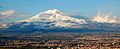
 Mount Koahau, Hudenkoon
 -
 Hills in North Kleenfoort, Kleenfoort
 -
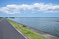 Lake Ourtana Path from Cincos to Tensadale, Tensadale, Norrsein
 -
 Carnside Valley, Embrosinet
 -
 Mount Kisahari, west Florovia, Florovia
 -
 Northern Bedous Hills, Oomient
 -
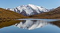 Lake Banden, Liisundiene


