Collab:Furgenia
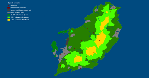
Furgenia (UL08n, map∈⊾) is a small state located on island in Mediterranean Sea. Based largely on historical papal states, the country is the seat of a Pope of Ortholic Church who is also a head of state. The state, however, is supposed to have secular, democratically elected administration, including small parliament. Culturally supposed to be based on Italy but language of mapping, as well as used by the population is supposed to be Latin (see section below).
The country is an open collaborative project meaning everybody can join after meeting requirements. That means applicant for mapping:
- Has no history of rule-breaking in recent past.
- Can demonstrate good quality, detailed mapping to coordinator.
- Has account for at least 3 months or has made at least 100 edits.
- Should be aware that religion is generally sensitive topic and should avoid controversy and changes in church doctrine.
Current coordinator is Rustem Pasha. If you are interested in the project and have read the rules below feel free to contact coordinator on the Wiki or through OGF direct message system. The coordinator has every right to remove you from the project team, if you enter a period of inactivity, and don't make a changeset within 4 months. After being removed from the team, your edits would be counted as invalid and other members have the right to delete or modify your mapping without your permission.
Users currently involved in the project:
Rules and useful information
What can I map?
The project is supposed to be focused on small scale mapping and should not deviate from the plan given below without discussion with the project community.

| Things allowed to map | Things requiring discussion |
|---|---|
|
|
The mapping should be good quality and cohesive with already mapped areas. You should also not interfere with mapping on which other members of the project already work without informing them to avoid conflicts.
Naming
As said above the country uses Latin as a mapping language. Classical Latin, as we know, is generally dead language and is not exactly suitable for usage in describing modern reality. Because of that usage of neoclassical Latin is required. There are several available resources in cases when own knowledge and available Latin translators are insufficient:
- Neolatin Lexicon
- Furgenian Latin - list of words related to mapping created by Imperator.
It is also important to note that Latin uses case system and all names created after a noun require a genitive form of that noun.
Additionally it is worth to remember that many geographic place names (such as rivers, towns and villages) may come from times predating the existence of Ortholic Church and Latin presence. That means they may be rooted in Etruscan instead of Latin and should not refer to religion at all. Religious names may be extensively present in naming streets and other more modern facilities.
Human geography and infrastructure
The country is supposed to be densely populated. However due to small size any railway infrastructure and high speed roads should not be mapped. Instead the island is supposed to be the home for many monasteries, a legacy of centuries long Church presence.
Given the small size of the country administrative the area is divided into several municipia (municipium, admin_level=5), already laid on map. The legations in the cities can be further divided into neighbourhoods (vicinia, admin_level=8).