File:Cromeleque dos Almendres - Portugal (4073246028).jpg

Original file (7,676 × 5,118 pixels, file size: 8.92 MB, MIME type: image/jpeg)
.jpg)
Summary
| Description |
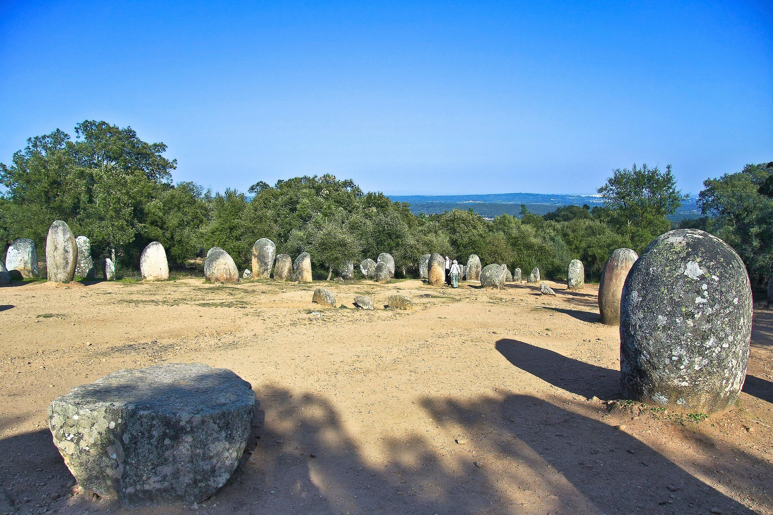
O Cromeleque dos Almendres é um monumento megalítico que está situado numa encosta voltada a nascente, na freguesia de Nossa Senhora de Guadalupe, concelho de Évora, Distrito de Évora. Trata-se do monumento megalítico mais importante de toda a Península Ibérica, não só devido à sua dimensão, mas também, devido ao seu estado de conservação. É também considerado um dos mais importantes da Europa. Está classificado pelo IPPAR como Imóvel de Interesse Público desde 1974. <a href="http://pt.wikipedia.org/wiki/Cromeleque_dos_Almendres" rel="nofollow">pt.wikipedia.org/wiki/Cromeleque_dos_Almendres</a> The Almendres Cromlech megalithic complex, located [show location on an interactive map] 38°33′28″N 08°3′41″W / 38.55778°N 8.06139°W / 38.55778; -8.06139Coordinates: [show location on an interactive map] 38°33′28″N 08°3′41″W / 38.55778°N 8.06139°W / 38.55778; -8.06139 near Guadalupe, Évora, Portugal, is one of the earliest public monuments. It is the largest existing group of structured menhirs in the Iberian Peninsula, and one of the largest in Europe. This megalithic monument originally consisted of more than one hundred monoliths[citation needed], some of which have been taken away for other uses. A recent dig showed that the complex had undergone several building phases during the neolithic period (5000 - 4000 b.c.)[citation needed]. It was found rather late, in 1964. 92 menhirs of different sizes currently form two grounds that were built oriented to different equinox directions. Several of them were put back in place[1][3]. The axis of the ovals is oriented along am east-west direction. The complex's position latitude is about the same as the maximum moon elongation (38,55 degrees for 1500 BCE); the other latitude at which that happens is that of Stonehenge, 51,18 degrees for 2000 BCE. About a dozen monoliths present some form of carved drawings, four of which exhibit only small circular holes. Monolith number 8, with a cut flat top at about breast level and showing several dimples, might have served for finer astronomical observation, specially spring equinox observation, by putting small stones on them. These observations might be made from stone 39, on the eastern focal point of the elliptic layout. It is believed that the monument had religious purposes and functioned as a primitive astronomical observatory. <a href="http://loc.alize.us/#/flickr:4073246028" rel="nofollow">See where this picture was taken.</a> <a href="https://www.flickr.com/groups/geotagging/discuss/72157594165549916/">[?]</a> |
| Date | |
| Source | Cromeleque dos Almendres - Portugal |
| Author | Vitor Oliveira from Torres Vedras, PORTUGAL |
| Camera location | | View this and other nearby images on: OpenStreetMap |
|---|
.jpg¶ms=038.557403_N_-008.061460_E_globe:Earth_type:camera_source:Flickr_&language=en)
Licensing
- You are free:
- to share – to copy, distribute and transmit the work
- to remix – to adapt the work
- Under the following conditions:
- attribution – You must give appropriate credit, provide a link to the license, and indicate if changes were made. You may do so in any reasonable manner, but not in any way that suggests the licensor endorses you or your use.
- share alike – If you remix, transform, or build upon the material, you must distribute your contributions under the same or compatible license as the original.
| This image was originally posted to Flickr by Portuguese_eyes at https://flickr.com/photos/21446942@N00/4073246028 (archive). It was reviewed on 28 March 2019 by FlickreviewR 2 and was confirmed to be licensed under the terms of the cc-by-sa-2.0. |
File history
Click on a date/time to view the file as it appeared at that time.
| Date/Time | Thumbnail | Dimensions | User | Comment | |
|---|---|---|---|---|---|
| current | 02:36, 28 March 2019 | | 7,676 × 5,118 (8.92 MB) | wikimediacommons>Tm | Transferred from Flickr via #flickr2commons |
File usage
The following page uses this file:
.jpg)