Ogesten

|
United Federation of Ogesten Ogestenin Yhdistynyt Liitto (Ogestenin) Capital: Vistju
Population: 5 331 143 (2025) Anthem: Me, Ogestenin asukkaat! |
Loading map... |
Ogesten Federation,United Federation of Ogesten (ogt.Ogestenin Yhdistynyt Liitto) A federation consisting, according to the Constitution, of 14 Oblasts, Separate Federal City of Vistju, Special Economic City Keippi and Tollkaia City. The country is located in eastern part of Uletha. It is bordered to the north by Neberly, to the west and south by UL22g. Above that, it has access to the Emerald Sea to the east. The capital is Vistju; the next largest urban area is a Keippi located about 47 kilometers southeast of Vistju.
| ||||
| United Federation of Ogesten Ogestenin Yhdistynyt Liitto | ||||
|---|---|---|---|---|
| ||||
Loading map... | ||||
| Anthem: Me, Ogestenin asukkaat! (We, people of Ogesten!) | ||||
| Capital | Vistju | |||
| Official languages | Ogestenin | |||
| Demonym | Ogestenian | |||
| Government | Federal parliamentary republic | |||
| • President | Tulla Miienen | |||
| • Chancellor | Timmo Haanha | |||
| Legislature | Central Government | |||
| HDI (2025) | very high | |||
| Timezone | WUT + 8 | |||
| Currency | Ogestenin krona (ok) (OGK) | |||
Geography
Climate
Ogesten is located in a zone of cool transitional temperate climate. Average July temperatures in the central part of the country range from +20 to +14 °C. In January, average temperatures range from -2 to -15°C. The length of the growing season in the south is 185-200 days, in the north - 120. The winter period usually occurs from mid-November to late March. The number of days per year with temperatures above +25 °C varies from 20-25 in the south to 5-7 in the north. The average annual precipitation in Vistju is 650 mm, with the highest in August. In the north, total precipitation is 500 mm.
Terrain
Administrative divisions
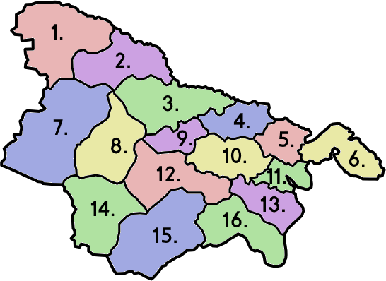
Ogesten is divided into 14 Oblasts (ogt. Seutu), Separate Federal City of Vistju, Special Economic City Keippi and Tollkaia City. Oblasts are divided into districts (ogt. Alue) and districts into municipalities. Each Oblast operates on the basis of its own autonomy regulated by the Vistju Central Government. Power in the Oblasts is exercised by the Autonomous Council, elected every 4 years in each Oblast. The Central Government is elected for an 8-year term. Five candidates from each Oblast sit on the Central Government.
| Map of Oblasts | Nubmer of
Oblast |
Flag of
Oblast |
Name | Capital |
|---|---|---|---|---|
| 1. | Nötö Seutu | Nötö | ||
| 2. | Vattala Seutu | Vattala | ||
| 3. | Jättolä Seutu | Jättolä | ||
| 4. | Harijatta Seutu | Harijatta | ||
| 5. | Oitti Seutu | Oiti | ||
| 6. | Metsämäki Seutu | Metsämäki | ||
| 7. | Hujaala Seutu | Hujaala | ||
| 8. | Sudenluola Seutu | Sudenluola | ||
| 9. | Sysmä Seutu | Sysmä | ||
| 10. | Vistju Seutu | Vistju | ||
| 11. | Keippi Seutu | Keippi | ||
| 12. | Uriaala Seutu | Uriaala | ||
| 13. | Relijatta Seutu | Relijatta | ||
| 14. | Kurjalla Seutu | Kurjalla | ||
| 15. | Kilyjarva Seutu | Kilyjarva | ||
| 16. | Ruukki Seutu | Ruukki |

