Forum:Territory application/AR019 - Marada: Difference between revisions
sketch |
Added a sketch and a few fixes. |
||
| Line 15: | Line 15: | ||
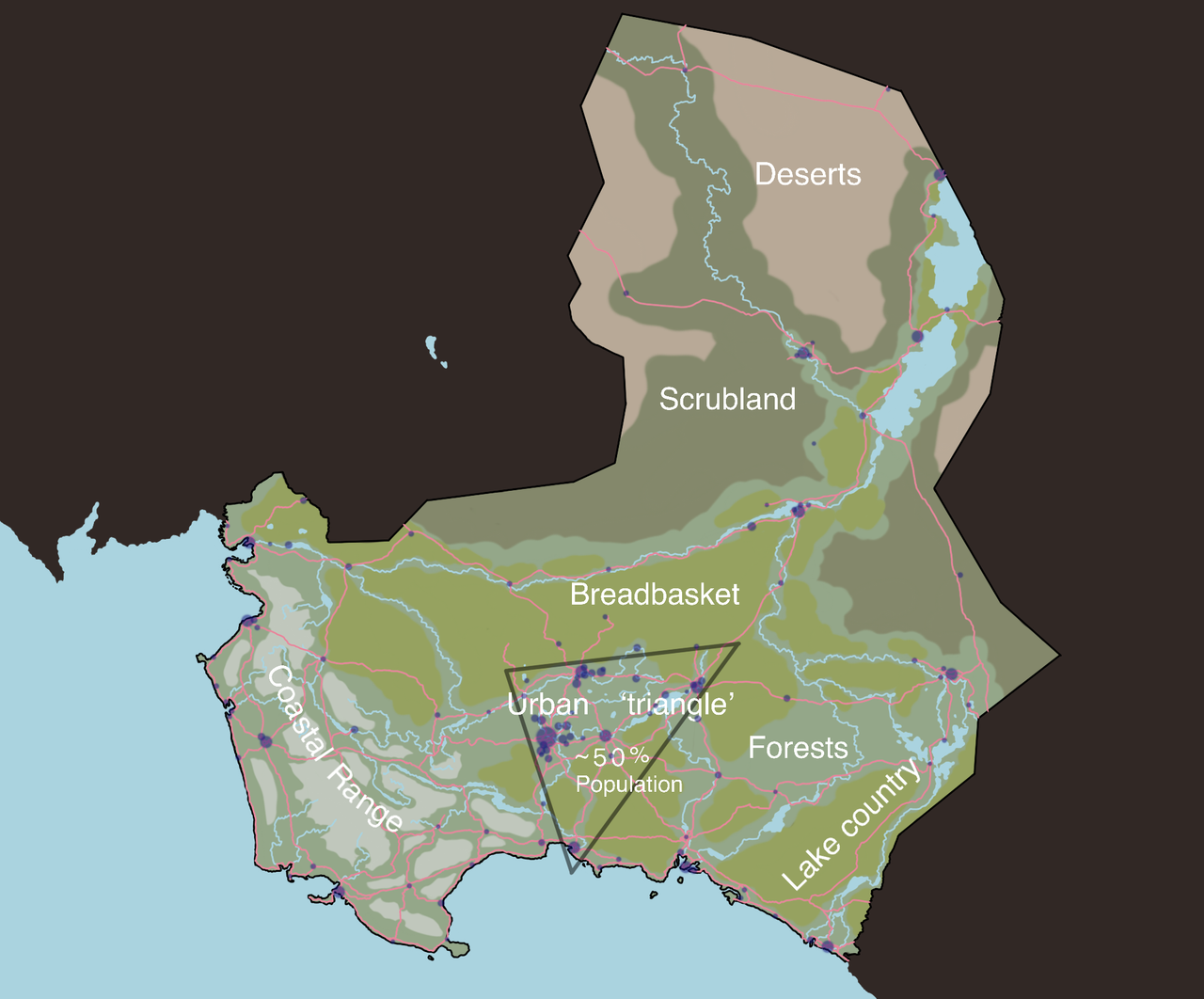
The physical geography of Marada is inspired by that of South Africa, Australia, Namibia, and the La Pampa of Argentina. Marada is home to a coastal range similar to Australia and South Africa that create a rain-shadow effect over the interior. In the northern portion of the territory, lies mostly deserts and scrubland that is inspired by the La Pampa and Namib deserts. This region is only broken up by a chain of large lakes along the nation's longest river. Along the border with Mecyna is a territory covered in vast array of lakes. | The physical geography of Marada is inspired by that of South Africa, Australia, Namibia, and the La Pampa of Argentina. Marada is home to a coastal range similar to Australia and South Africa that create a rain-shadow effect over the interior. In the northern portion of the territory, lies mostly deserts and scrubland that is inspired by the La Pampa and Namib deserts. This region is only broken up by a chain of large lakes along the nation's longest river. Along the border with Mecyna is a territory covered in vast array of lakes. | ||
[https://i.postimg.cc/7ZyB2mcr/Marada.png Sketch] | |||
{{territory application human geography}} | {{territory application human geography}} | ||
Marada is broken into five main cultures (and their respective proposed percentage of the population): English (79%), Kliprivi (7%), Natives (7%), Colombiane (4%), and Immigrants (3%). Marada has a population of around 9 million, with a large portion residing in and around the inland capital. The capital is the Constantia, which has a population of about 700,000. The capital, and many of the other larger cities are home to many ethnic communities ranging in size. The urban areas of Marada are inspired by that of Australia, New Zealand, South Africa, Canada, and the United States. Economically, Marada is quite prosperous in its urban centers, while it's rural regions lag behind the national average in some parts. This disparity should be similar to that of the United States, and in some regions, as drastic as in South Africa. The many cities are interconnected by a fairly decent rail network, although it was one that was largely constructed with industry in mind, and public transportation was an after thought. | Marada is broken into five main cultures (and their respective proposed percentage of the population): English (79%), Kliprivi (7%), Natives (7%), Colombiane (4%), and Immigrants (3%). Marada has a population of around 9 million, with a large portion residing in and around the inland capital. The capital is the Constantia, which has a population of about 700,000, is also a part of the larger 'urban triangle' that consists of 5 large cities that boast ~50% of the Maradese population. The capital, and many of the other larger cities are home to many ethnic communities ranging in size. The urban areas of Marada are inspired by that of Australia, New Zealand, South Africa, Canada, and the United States. Economically, Marada is quite prosperous in its urban centers, while it's rural regions lag behind the national average in some parts. This disparity should be similar to that of the United States, and in some regions, as drastic as in South Africa. The many cities are interconnected by a fairly decent rail network, although it was one that was largely constructed with industry in mind, and public transportation was an after thought. Agriculturally, most of the country is either used for ranching, or, in the breadbasket throughout the central part of the country, it is used for crop farming like seen in the state of Victoria, Australia. | ||
Contrary to just north of Marada, Bantu populations do not really exist in the territory. I wanted to keep the only natives of the territory a mix of both Khoisan peoples and Aboriginals, and maybe the sizable desert to the north stopped the migration of Bantus further south. | Contrary to just north of Marada, Bantu populations do not really exist in the territory. I wanted to keep the only natives of the territory a mix of both Khoisan peoples and Aboriginals, and maybe the sizable desert to the north stopped the migration of Bantus further south. | ||
| Line 42: | Line 44: | ||
* Please add a sketch map of your proposal. Thanks/[[User:Wangi|wangi]] ([[User talk:Wangi|talk]]) 09:58, 29 December 2025 (UTC) | * Please add a sketch map of your proposal. Thanks/[[User:Wangi|wangi]] ([[User talk:Wangi|talk]]) 09:58, 29 December 2025 (UTC) | ||
I added a sketch like you requested. [[User:Triestine|Triestine]] ([[User talk:Triestine|talk]]) 16:49, 29 December 2025 (UTC) | |||
<!-- replace this with {{territory application approved|summary of decision and signature|optionally useful information for the user}} or {{territory application closed|summary of decision and signature|optionally useful information for the user}} on closing --> | <!-- replace this with {{territory application approved|summary of decision and signature|optionally useful information for the user}} or {{territory application closed|summary of decision and signature|optionally useful information for the user}} on closing --> | ||
{{territory application in progress}} | {{territory application in progress}} | ||
Revision as of 16:49, 29 December 2025
- Please fill in the information below to make a territory request.
| Territory ID and proposed name | |
|---|---|
| The Territory ID (from OpenGeofiction:Territories, e.g. AR123a) and proposed name of the country |
AR019 - Marada (officially the Commonwealth of Marada)
| Physical geography | |
|---|---|
| An overview of climate, topography and landscape of the country. With the exception of Beginner territories, you should always create a sketch map to illustrate & explain your plans. You can add a link to this (hosted on imgBB, Postimages or similar, but not imgur.com) |
The physical geography of Marada is inspired by that of South Africa, Australia, Namibia, and the La Pampa of Argentina. Marada is home to a coastal range similar to Australia and South Africa that create a rain-shadow effect over the interior. In the northern portion of the territory, lies mostly deserts and scrubland that is inspired by the La Pampa and Namib deserts. This region is only broken up by a chain of large lakes along the nation's longest river. Along the border with Mecyna is a territory covered in vast array of lakes.
 | Human geography |
|---|---|
| A brief description of the territory demographics, economic development, land occupation, infrastructure and mapping style |
Marada is broken into five main cultures (and their respective proposed percentage of the population): English (79%), Kliprivi (7%), Natives (7%), Colombiane (4%), and Immigrants (3%). Marada has a population of around 9 million, with a large portion residing in and around the inland capital. The capital is the Constantia, which has a population of about 700,000, is also a part of the larger 'urban triangle' that consists of 5 large cities that boast ~50% of the Maradese population. The capital, and many of the other larger cities are home to many ethnic communities ranging in size. The urban areas of Marada are inspired by that of Australia, New Zealand, South Africa, Canada, and the United States. Economically, Marada is quite prosperous in its urban centers, while it's rural regions lag behind the national average in some parts. This disparity should be similar to that of the United States, and in some regions, as drastic as in South Africa. The many cities are interconnected by a fairly decent rail network, although it was one that was largely constructed with industry in mind, and public transportation was an after thought. Agriculturally, most of the country is either used for ranching, or, in the breadbasket throughout the central part of the country, it is used for crop farming like seen in the state of Victoria, Australia.
Contrary to just north of Marada, Bantu populations do not really exist in the territory. I wanted to keep the only natives of the territory a mix of both Khoisan peoples and Aboriginals, and maybe the sizable desert to the north stopped the migration of Bantus further south.
| History & culture | |
|---|---|
| A brief description of the intended culture and language |
History - The first contact the region had with any non-natives or Bantu peoples from the north, were with the Spanish, who had navigated and mapped the western coast and the main cape (possibly en route to Castilea Archanta?). These Spanish explorers had found refuge during a storm in one of plenty roadsteads along the coast, and, dubbed the region the 'Mar de Radas' (or 'Sea of Roadsteads'). The Spanish would never end up settling the region too much, but took the land under their crown. Eventually, around the seventeenth-century, the territory would have been sold to the Dutch. The Dutch were able to settle much of the interior and had pushed the natives out of the west. These Dutch settlers became known as the 'Kliprivi', after the name of their colony of 'Kliprivier'. Eventually, after around a century of Dutch rule, the colony was awarded to the English. The English would eventually, after many wars with the natives, Bantus, and now Kliprivi, come to dominate most of the country. This is besides the southern portion, nearest the border with Mecyna which would have been the French colony of 'Colombes', which joined the Commonwealth of Marada in the 19th century.
Culture and Language - Culturally, Marada is very homogeneous, with an overwhelming majority of the population speaking English in and out of home, and a mix of customs from the Commonwealth nations of Australia, New Zealand, Canada, and South Africa.
Mapping Language - all of the mapping, excluding some town names and land features like rivers, will be done in English. The Maradese dialect of written English will differ slightly, with a trailing '-e' added to certain words, and Commonwealth spellings of words such as 'Centre' and '-towne'. The word 'river' will almost always be spelled as the Kliprivi 'rivier', with only minor exceptions elsewhere.
| Past mapping | |
|---|---|
| To support your request provide links to areas of OGF mapping which showcase your mapping skill. Mapping relevant to the requested theme & geography is especially useful. | |
| The {{coord}}, {{node}}, {{relation}} or {{scalehelper}} templates can optionally be used to link to the OGF map - they result in nicely formatted links. Or you can paste in a URL. |
| Username & date | |
|---|---|
| Sign and date the application by typing four tildes (~~~~) without spaces or "nowiki" tags. |
Triestine (talk) 04:57, 29 December 2025 (UTC)
 | Discussion |
|---|---|
| Discussion for clarification & decision |
I added a sketch like you requested. Triestine (talk) 16:49, 29 December 2025 (UTC)