Ateria: Difference between revisions
Enderbyte09 (talk | contribs) No edit summary |
Enderbyte09 (talk | contribs) m (→Highways) |
||
| Line 76: | Line 76: | ||
=== Highways === | === Highways === | ||
The highways in Ateria are presently in a state of disarray. They are being updated. | |||
=== Airports === | === Airports === | ||
Revision as of 18:55, 6 June 2023
VISIT WEBSITE: HERE
Ateria is the fifth province in Deodeca. It's codename is AR060-05. It is the "southwestern" province in Deodeca as a whole. It has a population of 5.5 million people. It borders [PRESENTLY UNCLAIMED] to the Northwest and Oachanuntakan to the East. It borders Ardencia with one crossing (Highway 17). It also borders Ambroisie to the West and has five crossings (TDH-2, 27, 87, 61, 81)
Pre-Ulethan History
Ingerish colonizers as opposed to franquese ones...
[TODO]!
Modern History
[TODO]!
Landscape
Ateria is one of the five landlocked provinces. That said, it does contain a portion of the largest lake: Lake Oachanuntakan (OA). This lake is fed mostly by the Ateria River and Winding River, the former of which is an amalgamation of the Ateria, Ruby, and Kelekel Rivers.
Climate
Being surrounded by mountains, Ateria experiences significantly more precipitation in the south than neighbouring provinces due to trapped moisture. The north of the province has a CSB to BSH Koppen classification while the south (Midway and S) has a DFB (cool, no dry season, warm summers). However, the same can not be said about the north which is rather dry and has a Semiarid classification.
Government Database
Everything is logged by the Government of Ateria. Buildings are logged by the last six of seven digits of their postal code. Citizens are given an integer value from C-00000001 to C-99999999. C-codes are for citizens. R-Codes are for permanent residents and may be assigned a value from 0 to 100 million. After a person is deceased their number is NOT freed up
Regions, Districts, and Post
Ateria uses a dual-hierarchial system for subdenominations of land use. Province -> Region (ABCDEF) Region -> District (Region letter plus a number from 0-99) These are used for electoral boundaries, post service and provincial/national matters. Towns and cities are independent but in most cases follow district boundaries.
Post system follows lnlnln format, like Canada. This is divided in to [Province][District-subdist (2 chars)][Code(3chars)] followed by a letter descriptor. There are 12 million possible unique postal codes. The last 6 characters of a buildings postal code (including the descriptor) are used for the SystemBuildingCode.
| Code | Name | Population | Postal Code | Notes |
|---|---|---|---|---|
| A | Region of Glenburn | 4,080,000 | J0A0A0-A -> J6Z9Z9-Z | Encompasses the city and surrounding suburbs.
Includes Ambrosia Island and New Renwick |
| B | Region of Winding River | 958,000 | J7A0A0-A -> J8Z9Z9-Z | Pascal inlet, Winding River Valley, Rockfield, Rockdale, etc |
| C | Region of Massif
Région de Sud et Massif |
254,000 | J9A0A0-A -> J9M9Z9-Z | Massif Southill, Proxima (contains a majority of the Franquese population) |
| D | Region of the Western Plains
Région de le ouest prairie |
87,000 | J9N0A0-A -> J9N4A0-A | Springwood Valley, Border with Ambroise, contains franquese population in west |
| E | Region of Hanapila | 183,000 | J9N40A0-B -> J9Y9Z9-Z | Contains Hanapila and not much else |
| F | Region of the North-east | 25,000 | J9Z0A0-A -> J9Z9Z9-Z | Barely populated, driest climate |
Infrastructure
Highways
The highways in Ateria are presently in a state of disarray. They are being updated.
Airports
| Name | Cities served | Runways | Gates | COde | Notes |
|---|---|---|---|---|---|
| Glenburn International Airport | Glenburn and suburbs | 4 | 148 | DGL | |
| Castleton-Midway Regional Airport | Castleton, Midway | 1 | 5 | DCM | Sometimes considered proxy airport to Glenburn |
| Southill regional airport | Southill | 1 | 3 | DSH | Very minimally used |
| Proxima Island Airfield | Proxima Island | 1 | 1 | DPX | |
| Winding River-Rockfield International Airport | Winding River, Rockfield | 2 | 49 | DWR | |
| Massif Airport | Massif | 3 | 15 | DMS | Based off an AirportCEO Airport |
| Hanapila Nicene Airport | Hanapila, Nicene | 3 | 8 | DXH |
Subway/Light Rail
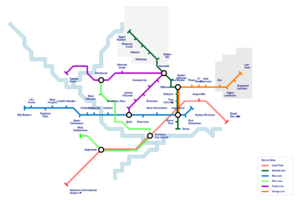
Both Massif and Glenburn have light-rail systems. Massif is mainly at-grade but Glenburn functions as more of a traditional underground/elevated train. In the map shown here, a double line is a train whereas the single line is a subway.
| Line Name | Stops | Year built | Notes |
|---|---|---|---|
| Bennett Line (Formerly Green line) | 13 | 1985 (extended 2000 and 2015) | Stops 9-13 are currently NYB |
| Blue Line | 15 | 1978 (extended 1999) | Topsham - Downtown |
| Orange Line | 11 | 1992 (extended 2015) | Stops 8-11 are currently NYB |
| Purple Line | 10 | 1978 (extended 2008 and 2022) | One of the two original lines |
| Red Local Train | 5 | 1964 (modernized 2015) | Local train, technically not LR |
| River Local Train | 5 | 1970 | Local train, technically not LR |
Bridges
| Name | Length | Highway | Notes |
|---|---|---|---|
| Bridge of Sorority | 7,000 m | Highway 27 | Riversend -> Armmouth |
| Mason Bridge | TDH-2 | Chelenston -> Glenburn | |
| Alexis Rowe Bridge | Highway 88 | ||
| Doyle Bridge | Highway 62 |
Demographics
Religion
Christic: 27%
Amyian: 32%
Sienist: 5%
Unaffiliated: 35%
Other: <1%


