Collab talk:Federal States/Railways/Companies: Difference between revisions
mNo edit summary |
|||
| Line 7: | Line 7: | ||
:It's been a while since we established this system. Can you remind me where the need of the map, and the company system at large, came from?--[[User:Fluffr Nuttr|Fluffr Nuttr]] ([[User talk:Fluffr Nuttr|talk]]) 05:02, 22 December 2021 (UTC) | :It's been a while since we established this system. Can you remind me where the need of the map, and the company system at large, came from?--[[User:Fluffr Nuttr|Fluffr Nuttr]] ([[User talk:Fluffr Nuttr|talk]]) 05:02, 22 December 2021 (UTC) | ||
::The current system came about in summer 2020, based on the advisory vote about railways, and then the system was developed, voted on, and passed 31-2. Documentation is available [https://wiki.opengeofiction.net/index.php/Collab:Federal_States/Railways/Resources#2020_Advisory_Survey here]. —[[User:TheMayor|TheMayor]] ([[User talk:TheMayor|talk]]) 13:10, 22 December 2021 (UTC) | ::The current system came about in summer 2020, based on the advisory vote about railways, and then the system was developed, voted on, and passed 31-2. Documentation is available [https://wiki.opengeofiction.net/index.php/Collab:Federal_States/Railways/Resources#2020_Advisory_Survey here]. —[[User:TheMayor|TheMayor]] ([[User talk:TheMayor|talk]]) 13:10, 22 December 2021 (UTC) | ||
:::As far as an updating of the older map, I think this is a fair, balanced approach. — [[User:Alessa|Alessa]] <sub>([[User talk:Alessa|talk]])</sub> 19:11, 22 December 2021 (UTC) | |||
Revision as of 19:11, 22 December 2021
Updated Map
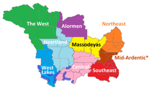
Submitted for review is an updated railway zone map, since there have been several changes in the FSA since the last sketch. Major differences:
- The Alormen Zone now wraps along the coast to include Alamar and San Pascual.
- Since Wilthamshire and Caroline have been merged, Wilthamshire is now part of the Northeast Zone, with the extreme southwest corner remaining in the Mid-Ardentic Zone to maintain the existing system on the Massodeya City-Huntington corridor.
- State boundaries have been updated to current versions.
Any other thoughts or comments on this update? -TheMayor (talk) 19:23, 21 December 2021 (UTC)
- It's been a while since we established this system. Can you remind me where the need of the map, and the company system at large, came from?--Fluffr Nuttr (talk) 05:02, 22 December 2021 (UTC)
