Forum:Official collaboratives/Gobras City - SW transport options
Summary
|
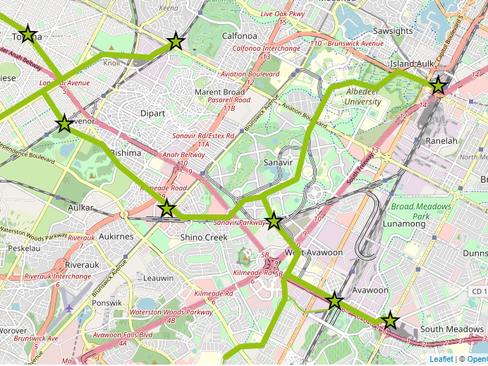
There has been discussion on Discord regarding new tram alignments in southwest Gobras City. The incongruous Sanavir Airtrain has been removed, with the area pending some rework based on what's agreed for the wider area. So, does the area require additional transport infrastructure?
But, why - is there a need? Would it be unrealistic, what would be the driver for such an infrastructure investment? wangi (talk) 22:42, 2 December 2022 (UTC) |
Loading map... railway, subway, tram, potential tram alignments? |
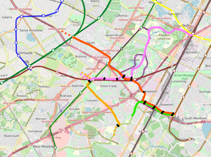
Draft maps
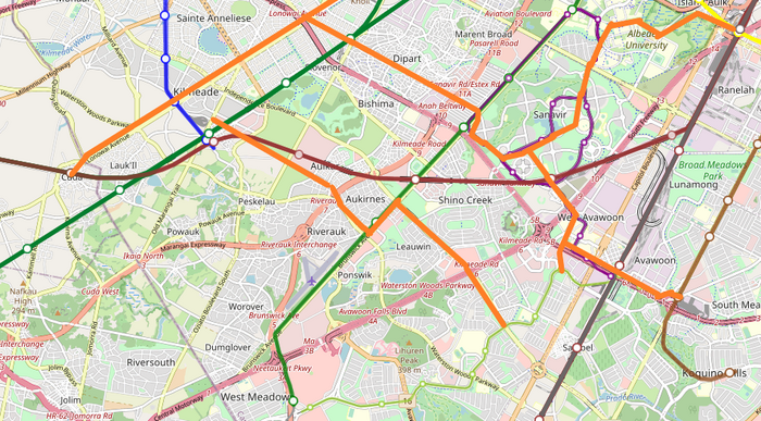
Existing transportation in the area:
https://wiki.opengeofiction.net/util/route_relations.html?map=C/13/20.61501/86.63928
Discussion
Please share you thoughts, to try and build up consensus on this development. Thanks/wangi (talk) 22:42, 2 December 2022 (UTC)
Just throwing in some views on the subject matter (I haven't read Zhenkangs post yet): Line M (what's called line 2 on the little map) was also present for a very long time already, and I think it's fine as is, connecting Avawoon East to West Meadows and serving a bunch of neighbourhoods along the way, feeding to the rail and metro lines. The only change that was (half) made was to move it slightly more towards the Avawoon Medical Center, which seems sensible.
In case of Sanavir, the whole area gives an experimental vibe to me, where developers wanted to 'fix' city issues by throwing some new (probably failed by now) concept at it. In that sense, the Sanavir Airtrain was quite fitting. However, it was way overbuilt for the mapped density. Even when potentially densifying those circles further, the area is still mostly parks. An elevated rail service, even if it were only gadgetbahn type 'pods', would just have been way too costly to build and maintain for the private developer of the area (a government would be even less likely to throw money at it, given it only benefits a single neigbourhood). But I'm also not sure if an at grade tram alignment would actually be a good alternative, because it doesn't fit well into the story. To me, it seems like a more localised and gadgetbahn-style form of transport makes somewhat sense, but it just has to be a lot cheaper than the previous elevated rail system. I'm specifically thinking of this: https://en.wikipedia.org/wiki/ParkShuttle. Only downside is it's from 1999, which might have been too late for the Sanavir area to be developed. So if a ground pod type thing is nothing to go by, why not make it some bike lane paradise, which might have been a fitting form of 'new' transport when the area was developed? Overall, I don't think that a higher form of non-local transport (i.e. government built tram line) would be necessary for Sanavir itself.
For the other lines, I think especially an east-west line might make sense (although, not sure what route would be best), since there's no metro doing anything like that. A long north-south line on the other hand would in general just be paralleling rail or metro lines and might not be justified, also given Sanavir doesn't really need it. Squizie3 (talk) 00:32, 3 December 2022 (UTC)
So, in hindsight, I'm not too much in favour of the previously proposed tram through Sanavir to Broad Meadows. More east-west oriented lines would have my preference over north-south ones. I don't know yet which east-west alignment(s) would make most sense tbh. But maybe... this is all a bit too early to say, as it was the idea to have a tram network sprawling from the Kilmeade-Tovena area with some lines then continuing towards the area we're now talking about, but Kilmeade itself is still in development and no base tram network exists in Tovena either. Maybe instead of rushing through changes, we can for now just find a suitable replacement for Sanavir's airtrain (be it tram, bus, pod, lots of bikeways, or else), and do the tram network later? Squizie3 (talk) 00:57, 3 December 2022 (UTC)
- Thanks both. I think it would lower the barrier to entry, if we can trim the Sanavir sections above. As stated, take it as a given that the Airtrain is gone and the area is being reworked. wangi (talk) 01:04, 3 December 2022 (UTC)
- It's possible that the tram through Sanavir could have taken over previous infrastructure meant for these gadgetbahns. An alternative tram route through the neighbourhood would have sufficed as an alternative perhaps to address residents' concerns about taking away a transport option.--Zhenkang (talk) 01:08, 3 December 2022 (UTC)
- I'm thinking about the preferred tram alignments by who they serve and where the tram would go. Provided that we increase the density of developments along the route, I think the north-south alignment through Albedeer University is a good candidate because it links the university to the retail areas in Island Aulk and West Meadows. University students typically take public transit, and the tram would help them make their transit connections to other parts of Gobras City efficiently to shop and to commute to their jobs outside the university. In addition, Sanavir has a lot of potential to develop retail parcels near existing and future stations along the tram route to serve park patrons and tram riders alike. I also think that if we're designing a tram, it should be to replace the existing bus route(s) that are operating at or above capacity due to the popularity of the route. Chazeltine (talk) 03:18, 6 December 2022 (UTC)
- I think access to subways is adequate for students, but maybe a short-distance shuttle bus can be implemented. There is a walkability issue right outside the university: Island Aulk is some distance away, and other surrounding retail stores are roadside malls, but the issue is hard to resolve unless significant changes to nearby neighbourhoods happen. I agree that there is insufficient demand for tram: Neetaukeit is a bedroom town and commuting pattern should be relatively fixed (thus can be satisfied by buses). --Austinhuang (talk) 22:58, 13 December 2022 (UTC)
Overall, I have two comments:
- From a transportation planner/urban historian perspective, the whole (a network) is greater than the sum of its parts.
- From a geofiction perspective, the SW tram network results from ideation around a large, pre-National Capital District/pre-car town center at Kilmeade that has been discussed extensively in theory but has yet to make its way to the map. I suggest we hold off on any final decisions until we see the shape of Kilmeade (no rush, I understand getting busy with life outside of OGF).
In more detail:
- From a transportation planning & historical perspective, this is supposed to be the remnants of a pre-car tramway network stitched together to make something useful today, in the context of a significant regional node - see Croydon, London, UK and the London trams that serve as a local distributor for 2 rail stations in Croydon, and then connecting to several other radial lines to Central London. It uses street running, some shared rail RoW, some converted exclusive rail RoW and some new construction. Perhaps Newark Light Rail could be a similar historical reference, but Croydon was the direct inspiration. The historical aspect means there is some sunk cost from generations ago, so we do not have to think about the cost and highest priority lines to build today, just whether the lines would continue to be used today. (This thought process should be applied to many potential mainline rail corridors in Gobrassanya.)
- If no further urban/high-density mapping (the regional node mentioned above) is added to the SW area, I propose deleting the existing West Meadows-Avawoon East tram line or converting to a busway. It is not a strong standalone tramway line, historically nor at present. The biggest ridership draws are assertively post-car and oriented to the busy A3/A202 motorways and longer-distance regional trips. Users of the Mall at West Meadows are far more likely to be drivers from the Axian Quarter, workers at the Beltway Green Office Park drivers from Araruuta, workers at the Neetaukeit Tech Center drivers from the towns near Milaukashka, etc. than public transport riders making last-mile connections on the tram. The neighborhoods along the tramway line seem assertively single-family, and the Riverglen Park that is walking distance from a lot of transit at West Meadows has the 'undetailed' greenspace issue that we have previously agreed is ok to redevelop to a higher use. Even Avawoon East, with its direct express lane entrance, serves as the South suburbs' largest metro Park & Ride and seems like a motorway-era extension rather than a pre-car station. This leg of the tram network only makes sense to me if it is part of a greater network with a larger installed user base, and hopefully partially historical in nature and not all new build, such that each successive extension only incurs a small marginal cost with significant user gains from network connectivity (aka, the short stretch from Avawoon to Avawoon East adding potential riders from up and down the M6/South Ormeo Ave that want to go to more places than just West Meadows).
- Sanavir sans Airtrain could use some internal circulation, and better connections to metro and regional rail. Albedeer University could use some internal circulation and better connections to metro and regional rail. Isaulk-Broad Meadows is a top-5/6 rail station in Gobras City (City Depot, Pohalashee Grand, Monuwali, GSWX, Isaulk/Tully Circus [less service but higher demand due to Enalee]), which is adjacent to the largest retail center between A101/A202, yet poorly connected to neighboring high density activity nodes. (Evergreen plea to think about the mainline rail lines as rapid transit, and include them on all transit maps of Gobras City.) Each one of these use cases may not necessitate a tramway individually, but added together, they create more demand than a bus route or 2 or even busway could satisfy. I would add that a tram could travel on a berm through wetlands on a faster RoW than the circuitous road network.
- The Kilmeade town center is the lynchpin of the network. If the town center is substantial enough (and anti-car enough), I would suggest at least the following tram segments, in addition to what is on the map and the sketches contributed in this thread (remembering network connectivity [small extensions can enable large ridership gains due to the multiple, diffuse origin & destination pairs they create] and hopefully historical tram routes that never lost service in the motorway era):
- A direct Kilmeade-West Meadows route (with enhanced urbanism in intervening areas implied), in addition to an 'Independence Blvd' route
- A Keena-Cuda route along Lonowai Ave that Chazeltine originally wanted for a metro line
- A handful of routes on the west side of Kilmeade, but Chazeltine & Squizie are best placed to identify them since they are the mappers - I think Sainte Annelise-Galaria-Caledon is one
Fin. --UnSoiDisantOracle (talk) 00:08, 17 December 2022 (UTC)
Broad consensus
Hi, trying to get some rough idea of feelings - please put your signature against the options below which you'd be happy enough to move forward. So, you can list under multiple. Thanks/wangi (talk) 22:31, 13 December 2022 (UTC)
- No need for trams
- wangi (talk) 22:31, 13 December 2022 (UTC)
- Austinhuang (talk) 22:58, 13 December 2022 (UTC)
- Chazeltine (talk) 02:23, 14 December 2022 (UTC)
- UnSoiDisantOracle (talk) 22:56, 16 December 2022 (UTC) - Surprisingly
- Green path N-S north-south tram alignment
- Chazeltine (talk) 02:23, 14 December 2022 (UTC)
- Zhenkang (talk) 03:08, 14 December 2022 (UTC)
- UnSoiDisantOracle (talk) 22:56, 16 December 2022 (UTC)
- Green path E-W east-west tram alignment
- Further, even more trams
- UnSoiDisantOracle (talk) 22:56, 16 December 2022 (UTC)
- UnSoiDisantOracle (talk) 22:56, 16 December 2022 (UTC)


