Forum:Request help/AN136 Split
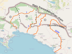
AN136 is a rather large territory in north/central Antarephia (534,147.49 km² / 206235.50 sq mi). It is conveniently located north of Paxtar. Along its northern border runs the main Transantarephian mountain chain from which 4 reasonably large international rivers originate: 1, 2, 3 and Şibār. 2, 3 and Şibār (upper valley in AN133) empty in Paxtaren territory.
To provide Central Antarephia with more "available" territories that would not qualify as "For advanced users only" because of their size, I would like to hear ideas from the wider OGF mapper community on how to split AN136 into 2 or 3 (maybe 4?) territories? Local topography would left to territories' owners to decide. Personally, I read this region of the map of being either some kind of Central Valley, milder parts of the Colorado Plateau or Great Basin, or various combinations of both.
