Forum:Territory application/AN127 - Casterlinia: Difference between revisions
No edit summary |
mNo edit summary |
||
| Line 14: | Line 14: | ||
{{territory application physical geography}} | {{territory application physical geography}} | ||
https://imgur.com/a/ | https://imgur.com/a/qQ2yuzA Climate zoomed in map from the wiki page of Antarephia | ||
As we can see on the map, the western part of the country is mainly semi-arid while the east is tropical, and a little bit, in the south there are parts that are arid. On the middle of the country lay the Shawkee mountains, an indigenous name given to the northern Antarephian mountain range branch, which is a colder mountain range with higher heights, on it's southwest, the mountainrange splits the climate in three in some way, separating arid from semiarid and tropical. The south of the country gets the least amount of rainfall in the entire country due to the arid climate, however it is very rich in resources. The ocean swell spins near Cygagon's East coast, making a lot of waves on the western coast. | |||
https://imgur.com/a/PJRHBSE Rivers and Topography map | |||
{{territory application history and culture}}Casterline was the name of | The southern moutainrange in the south of the country is has got highest points of elevation in the country, along with the Shawkee mountainrange having the second highest. Those mountainranges split Casterlinia from AN125 which has an arid climate due to the height of the mountains. The east river basin is the most arid region in the entire country and is also the area with the most rainfall. The peninsula on the north is called Jackson Peninsula, it splits two regions of the country, the tropical one and semi arid, this region has many irrigation infrastructure to support the agriculture. | ||
'''Landscape''' | |||
https://upload.wikimedia.org/wikipedia/commons/0/0f/Urue%C3%B1a_paisaje_lou.jpg -> Picture of West coast agriculture on the more humid areas and northern farmlands | |||
https://upload.wikimedia.org/wikipedia/commons/5/56/Byron_Lighthouse_looking_south_2004-28-12.JPG -> Picture of the West Coast | |||
https://upload.wikimedia.org/wikipedia/commons/c/c0/Ovacik1.jpg -> Picture of Manndeil River Valey / Shawkee Mountains | |||
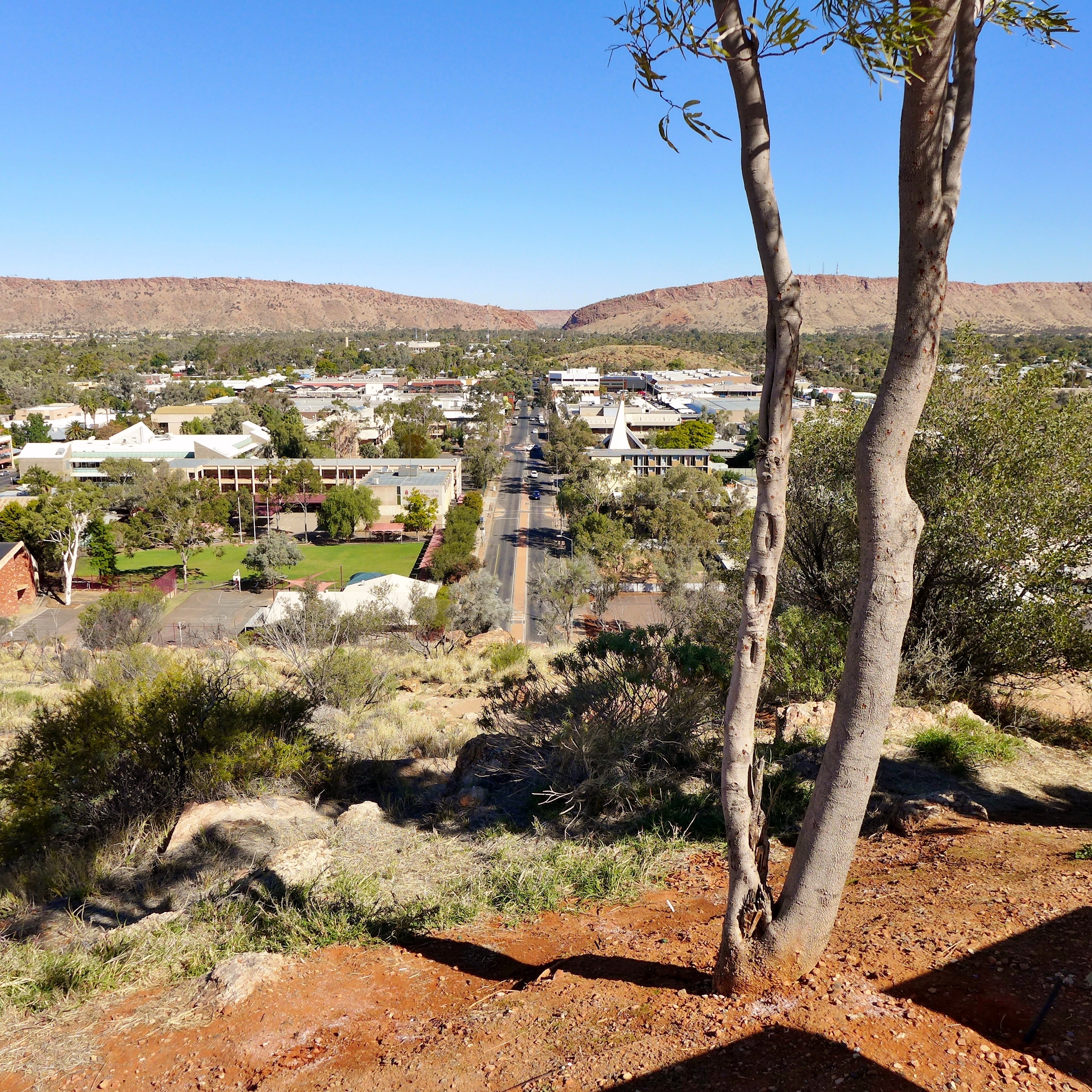
https://upload.wikimedia.org/wikipedia/commons/e/e7/Alice_Springs%2C_2015_%2801%29.JPG -> Picture of Southern Cities | |||
https://upload.wikimedia.org/wikipedia/commons/2/20/Praia_do_Forno_-_Arraial.jpg -> Picture of Eastern coast near Jackson Peninsula (northern Peninsula) | |||
https://upload.wikimedia.org/wikipedia/commons/d/d5/SerraGeralI.jpg -> Picture of farmlands in east plains | |||
{{territory application history and culture}} | |||
Casterline was the name of a Ingerish leader's wife, this colony was named after her, being named Casterlinia. Casterlinia was a colony of FSA for 256 years, and briefly colonized by a few southern Antarephian tribes before the FSA colonisation. This territory declared independence roughly 24 years ago, under the condition that it would become politically favorable to Ingerland. Due to the Ingerish occupation, the overall culture and language of the country is simillar to Australian culture, having simillar urban development processes as Australia. This also made the language of the country Ingerish, with it's own dialect. | |||
The Political system of this country is a Constitutional Democracy, very simillar to UK's political system in real life. The two major parties are the Conservative Casterline Party (CCP) and Liberal Democratic Party (LDP), as the majority of the country has a strong Middle-Left Political culture. | |||
{{territory application human geography}} | |||
https://imgur.com/a/3tjpm4H Link to the map of the major highways and cities | https://imgur.com/a/3tjpm4H Link to the map of the major highways and cities | ||
The urban development is very simillar to Australia, having cities with smaller highrise centers and bigger suburbs. Due to the job opportunities and economic development of the East coast, achieved through maritime trade, and the tropical climate, the east coast has the highest density of population, concentrated through the Jacksonville - New Heidelberg strip, an area with a lot of natural harbours. The eastern plains also are the most fertile in the entire country, and the plains with strong agriculture. On the West plains, more on the inland parts, a little bit of agriculture is present, however only near the rivers and coast, as the soil is dry. In the south, smaller cities are present, with smaller sizes. Their economies is also smaller, being more dependant on extraction of natural resources like iron and stone. On the west coast, the only big city present is Westhaven, a stablishment originally from a south Antarephian nation on a natural harbour that grew a lot in size due to the tourism economy during the ingerish occupation and the modern era. | |||
{{territory application past mapping}} | {{territory application past mapping}} | ||
| Line 38: | Line 59: | ||
https://opengeofiction.net/#map=13/-26.2472/166.1746&layers=B -> this was my first city mapped, it was mapped almost a month ago on Tierra Nueva, a blue territory | https://opengeofiction.net/#map=13/-26.2472/166.1746&layers=B -> this was my first city mapped, it was mapped almost a month ago on Tierra Nueva, a blue territory | ||
https://opengeofiction.net/#map=13/-37.0056/155.5247&layers=B -> Linden is the city I am actively working on, its twin city, Heidelberg, is also a city that is undergoing development, those are my main cities which I am working on. The areas near South Linden Lake are the most developed so far. The rural areas around Linden and Heidelberg were all mapped by me, the most developed ones are the ones on | https://opengeofiction.net/#map=13/-37.0056/155.5247&layers=B -> Linden is the city I am actively working on, its twin city, Heidelberg, is also a city that is undergoing development, those are my main cities which I am working on. The areas near South Linden Lake are the most developed so far. The rural areas around Linden and Heidelberg were all mapped by me, the most developed ones are the ones on north of Linden, west of Hannah Hamlet. | ||
{{territory application username and date}} | {{territory application username and date}} | ||
What3089 (Jake on the discord server [feel free to contact me there if more convenient]) ~10~6~ | What3089 (Jake on the discord server [feel free to contact me there if more convenient]) ~10~6~23 | ||
{{territory application discussion}} | {{territory application discussion}} | ||
Revision as of 16:39, 8 October 2023
- Please fill in the information below to make a territory request.
| Territory ID and proposed name | |
|---|---|
| The Territory ID (from OpenGeofiction:Territories, e.g. AR123a) and proposed name of the country |
AN127 - Casterlinia (Republic of Casterlinia)
| Physical geography | |
|---|---|
| An overview of climate, topography and landscape of the country. It is advised to also create a sketch, you can add a link to this (hosted on imgur or similar) |
https://imgur.com/a/qQ2yuzA Climate zoomed in map from the wiki page of Antarephia
As we can see on the map, the western part of the country is mainly semi-arid while the east is tropical, and a little bit, in the south there are parts that are arid. On the middle of the country lay the Shawkee mountains, an indigenous name given to the northern Antarephian mountain range branch, which is a colder mountain range with higher heights, on it's southwest, the mountainrange splits the climate in three in some way, separating arid from semiarid and tropical. The south of the country gets the least amount of rainfall in the entire country due to the arid climate, however it is very rich in resources. The ocean swell spins near Cygagon's East coast, making a lot of waves on the western coast.
https://imgur.com/a/PJRHBSE Rivers and Topography map
The southern moutainrange in the south of the country is has got highest points of elevation in the country, along with the Shawkee mountainrange having the second highest. Those mountainranges split Casterlinia from AN125 which has an arid climate due to the height of the mountains. The east river basin is the most arid region in the entire country and is also the area with the most rainfall. The peninsula on the north is called Jackson Peninsula, it splits two regions of the country, the tropical one and semi arid, this region has many irrigation infrastructure to support the agriculture.
Landscape
https://upload.wikimedia.org/wikipedia/commons/0/0f/Urue%C3%B1a_paisaje_lou.jpg -> Picture of West coast agriculture on the more humid areas and northern farmlands
https://upload.wikimedia.org/wikipedia/commons/5/56/Byron_Lighthouse_looking_south_2004-28-12.JPG -> Picture of the West Coast
https://upload.wikimedia.org/wikipedia/commons/c/c0/Ovacik1.jpg -> Picture of Manndeil River Valey / Shawkee Mountains
https://upload.wikimedia.org/wikipedia/commons/e/e7/Alice_Springs%2C_2015_%2801%29.JPG -> Picture of Southern Cities
https://upload.wikimedia.org/wikipedia/commons/2/20/Praia_do_Forno_-_Arraial.jpg -> Picture of Eastern coast near Jackson Peninsula (northern Peninsula)
https://upload.wikimedia.org/wikipedia/commons/d/d5/SerraGeralI.jpg -> Picture of farmlands in east plains
| History & culture | |
|---|---|
| A brief description of the intended culture and language |
Casterline was the name of a Ingerish leader's wife, this colony was named after her, being named Casterlinia. Casterlinia was a colony of FSA for 256 years, and briefly colonized by a few southern Antarephian tribes before the FSA colonisation. This territory declared independence roughly 24 years ago, under the condition that it would become politically favorable to Ingerland. Due to the Ingerish occupation, the overall culture and language of the country is simillar to Australian culture, having simillar urban development processes as Australia. This also made the language of the country Ingerish, with it's own dialect.
The Political system of this country is a Constitutional Democracy, very simillar to UK's political system in real life. The two major parties are the Conservative Casterline Party (CCP) and Liberal Democratic Party (LDP), as the majority of the country has a strong Middle-Left Political culture.
 | Human geography |
|---|---|
| A brief description of the territory demographics, economic development, land occupation, infrastructure and mapping style |
https://imgur.com/a/3tjpm4H Link to the map of the major highways and cities
The urban development is very simillar to Australia, having cities with smaller highrise centers and bigger suburbs. Due to the job opportunities and economic development of the East coast, achieved through maritime trade, and the tropical climate, the east coast has the highest density of population, concentrated through the Jacksonville - New Heidelberg strip, an area with a lot of natural harbours. The eastern plains also are the most fertile in the entire country, and the plains with strong agriculture. On the West plains, more on the inland parts, a little bit of agriculture is present, however only near the rivers and coast, as the soil is dry. In the south, smaller cities are present, with smaller sizes. Their economies is also smaller, being more dependant on extraction of natural resources like iron and stone. On the west coast, the only big city present is Westhaven, a stablishment originally from a south Antarephian nation on a natural harbour that grew a lot in size due to the tourism economy during the ingerish occupation and the modern era.
| Past mapping | |
|---|---|
| To support your request provide links to areas of OGF mapping which showcase your mapping skill. Mapping relevant to the requested theme & geography is especially useful | |
| The {{coord}} template can optionally be used to link to the OGF map - it results in a nice formatted link. Or you can paste in a URL. |
https://opengeofiction.net/#map=13/-26.2472/166.1746&layers=B -> this was my first city mapped, it was mapped almost a month ago on Tierra Nueva, a blue territory
https://opengeofiction.net/#map=13/-37.0056/155.5247&layers=B -> Linden is the city I am actively working on, its twin city, Heidelberg, is also a city that is undergoing development, those are my main cities which I am working on. The areas near South Linden Lake are the most developed so far. The rural areas around Linden and Heidelberg were all mapped by me, the most developed ones are the ones on north of Linden, west of Hannah Hamlet.
| Username & date | |
|---|---|
| Sign and date the application by typing four tildes like this: ~~~~ |
What3089 (Jake on the discord server [feel free to contact me there if more convenient]) ~10~6~23
 | Discussion |
|---|---|
| Discussion for clarification & decision |