Forum:Territory application/AR047-05 Terrensonnee: Difference between revisions
No edit summary |
No edit summary |
||
| Line 44: | Line 44: | ||
Oh wow that is another level of carto wizardry altogether on the topo layer that I didn't even see before. All a little too complicated for me and I don't suppose I'd be able to contribute at a level that will do you justice; I think I'll stick to geofictional vector maps in illustrator! Application hereby withdrawn, apologies for any inconvenience. | Oh wow that is another level of carto wizardry altogether on the topo layer that I didn't even see before. All a little too complicated for me and I don't suppose I'd be able to contribute at a level that will do you justice; I think I'll stick to geofictional vector maps in illustrator! Application hereby withdrawn, apologies for any inconvenience. | ||
:I don't think Luciano was trying to scare you off. OGF is for everyone, and the mapping you've already done is more than sufficient to successfully request a territory of your own. I think Luciano's point was just that there is existing topo mapped in Ooayatais and ensuring that any plan you have for the territory makes logical sense at a macro level, rather than expecting you to map at the same level of detail. I do hope you reconsider the withdrawal of your application (although if you'd prefer to have a less "intimidating" neighbor, there are plenty of other options available as well). --[[User:TheMayor|TheMayor]] ([[User talk:TheMayor|talk]]) 20:54, 7 July 2023 (UTC) | |||
<!-- replace this with {{territory application approved|summary of decision and signature|optionally useful information for the user}} or {{territory application closed|summary of decision and signature|optionally useful information for the user}} on closing --> | <!-- replace this with {{territory application approved|summary of decision and signature|optionally useful information for the user}} or {{territory application closed|summary of decision and signature|optionally useful information for the user}} on closing --> | ||
{{territory application in progress}} | {{territory application in progress}} | ||
Revision as of 20:54, 7 July 2023
- Please fill in the information below to make a territory request.
| Territory ID and proposed name | |
|---|---|
| The Territory ID (from OpenGeofiction:Territories, e.g. AR123a) and proposed name of the country |
AR047-5 Terrensonnee (Withdrawn)
| Physical geography | |
|---|---|
| An overview of climate, topography and landscape of the country. It is advised to also create a sketch, you can add a link to this (hosted on imgur or similar) |
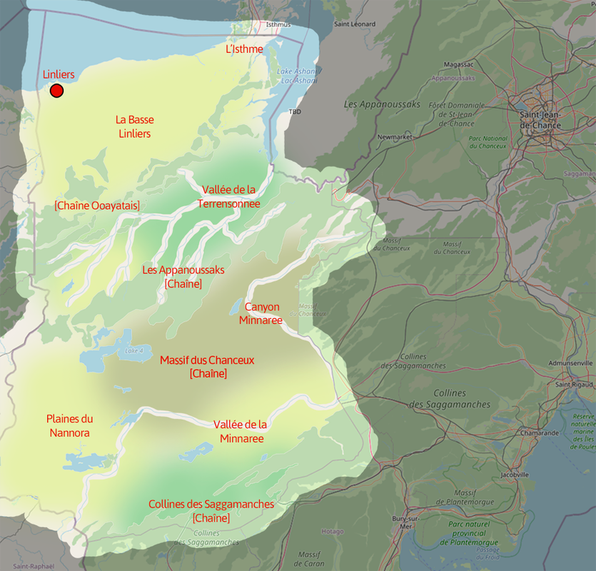
https://i.postimg.cc/SxXf9ykJ/Terrensonnee-Plan.png
Sitting across the 45° southern parallel the territory might be expected to have a temperate to cold climate. I propose to continue the highland and mountainous ranges from the eastern Astrasian states (the Appanousaks, Chanceux and Saggamanches ranges) and from the western territory of Ooayatais, part of the Ardence project held by Luciano, which may be unnamed (possibly Carcajous or Saganausca) and is indicated on the sketch as Chaîne Ooayatais. These ranges will largely remain unpopulated forested regions, at some parts quite dense and inaccessible. The territory is bisected by two existing river systems, which I propose to name Terrensonnee and Minnaree. The Terrensonnee valley will be a remote and heavily forested watercourse while the Minnaree, after forging a large canyon system close to source through the Chanceux Massif, will fall into a wide, sheltered and fertile valley given over in large part to agricultural use. To the west of the territory will be a large cool savannah, the Nannora plain, with small pockets of agriculture in more sheltered areas. The northern lowland falling to Lake Wihinapa will be the most temperate and accessible zone and therefore the most populous, but the larger part of it will be given over to agricultural production.
 | Human geography |
|---|---|
| A brief description of the territory demographics, economic development, land occupation, infrastructure and mapping style |
I intend to follow the mapping styles of neighbouring territories, particularly Ardence to the west. The territory/state capital, Linliers, will be to the north on the shore of Lake Wihinapa. Whilst the largest population centre of the territory, I plan for it to be considerably smaller than Saint-Jean-de-Chance, probably comparable with Ohunkagan, a near neighbour across the lake in Makaska state, of the FSA. Wiki indications have Ohunkagan's populaiton at approximately 2m but I would think Linliers to be around half that again. I intend for this to be the cultural and industrial hub of the territory, well connected by transport lines continued from west and northern territories, perhaps extending east into Ooayatais and twinned - in economic and industrial terms - with Ohunkagan, as well as being a centralised outlet for the considerable agricultural production of the surrounding lowland area, La Basse Linliers. Smaller population centres will be drawn up particularly in this lowland area, in the Minnaree valley and to some extent on the Nannora plains, but I would not expect to map any other large cities, perhaps with limitations of up to 30k for townships dotted around the territory, maybe a 100k city in the Minnaree valley as the 'second city' of the territory.
| History & culture | |
|---|---|
| A brief description of the intended culture and language |
I am keen to follow the plan for this territory as a developed francophile nation, former colony, with indiginous influences, using Quebecois-inspired names for much labelling along with a selection of native american linguistic influences, and in some cases the odd colonial English-American name.
A sample intended names - Alivina, Anesine, Belinia, Belzanie, Clarenne, Colomba, Lacordia, Lexine, Oceanne, Romane; Summernola, Glento, Multaine, Crosrane, Terrensonnee, Magnus, Nannora, Palaniuk, Minnaree, Kingsheller, Melville, Bentona, Linliers, Osona, Onolis, Orephia, Clarennia/Clarenne.
| Past mapping | |
|---|---|
| To support your request provide links to areas of OGF mapping which showcase your mapping skill. Mapping relevant to the requested theme & geography is especially useful | |
| The {{coord}} template can optionally be used to link to the OGF map - it results in a nice formatted link. Or you can paste in a URL. |
https://opengeofiction.net/#map=15/13.9200/-111.7562&layers=B
I completed this piece as my demonstration work. I don't think I will use the same mapping theme as this is largely of British and north European style, started before I had really considered which territory I would like to map. I wanted to create a large variation in a small area to cover rural, urban and industrial mapping; so this has been drafted as a section of an orbital motorway, in which the inner zone would likely condense into heavy urbanised zones, but the orbital itself would form a sort of boundary between the developed and rural surroundings.
| Username & date | |
|---|---|
| Sign and date the application by typing four tildes like this: ~~~~ |
J33 (talk) 06:40, 7 July 2023 (UTC)
 | Discussion |
|---|---|
| Discussion for clarification & decision |
- I'd welcome a new Francophone neighbor to the east of Ooayatais. Ooayatais is quite Quebec / Canada influenced - I tend to approach it as a kind of Francophone re-imagining of Saskatchewan (north) and British Columbia (south). The two main native groups are the Rakhoda (= real world Dakota / Lakota / Nakota) and Haïde (= real world Haida). My aim with native names is to be linguistically authentic to those real-world sources, so most native names have true etymologies. Bear in mind the topography of Ooayatais is fully established via the topo layer: https://opengeofiction.net/#map=8/-44.731/146.591&layers=V . Sainte-Jeanne is badly mapped (it's really just a quick, high-level sketch and subject to change), but I've made some good progress with the "second capital" in the south, Saint-Raphaël: https://opengeofiction.net/#map=14/-46.6367/146.7466&layers=B. --Luciano (talk) 14:56, 7 July 2023 (UTC)
Oh wow that is another level of carto wizardry altogether on the topo layer that I didn't even see before. All a little too complicated for me and I don't suppose I'd be able to contribute at a level that will do you justice; I think I'll stick to geofictional vector maps in illustrator! Application hereby withdrawn, apologies for any inconvenience.
- I don't think Luciano was trying to scare you off. OGF is for everyone, and the mapping you've already done is more than sufficient to successfully request a territory of your own. I think Luciano's point was just that there is existing topo mapped in Ooayatais and ensuring that any plan you have for the territory makes logical sense at a macro level, rather than expecting you to map at the same level of detail. I do hope you reconsider the withdrawal of your application (although if you'd prefer to have a less "intimidating" neighbor, there are plenty of other options available as well). --TheMayor (talk) 20:54, 7 July 2023 (UTC)