Forum:Territory application/UL08e - Avragne: Difference between revisions
(Created page with " <div class="forumheader" style="margin: 1; background-color: #eeeeee; text-align: left; padding: 5px;">'''Forums → Forum:Territory application|Territor...") |
Bixelkoven (talk | contribs) (Territory application approved) |
||
| (One intermediate revision by one other user not shown) | |||
| Line 61: | Line 61: | ||
* [https://opengeofiction.net/#map=15/12.9009/-111.8857&layers=B Initial village sketch] | * [https://opengeofiction.net/#map=15/12.9009/-111.8857&layers=B Initial village sketch] | ||
(These tiles may still be in the process of updating) | |||
{{territory application username and date}} | {{territory application username and date}} | ||
| Line 73: | Line 74: | ||
{{territory application approved|Approved; no large changes to plans required ⸺ [[User:Bixelkoven|Bixelkoven]] ([[User talk:Bixelkoven|talk]]) (West Uletha Admin) 22:15, 30 March 2024 (UTC)|Your provided mapping is quite good and is in par with the style imagined for the territory. It's not the largest in quantity, and I would've liked to see some mountainous mapping as well, however I trust you will provide good mapping examples of those in the future as well. Friendly suggestion to limit using grids from your urban mapping, feel free to experiment with free-flow street layouts more. Your geography plan is okay, do note that the mountains on your western border would be your main and highest mountain chain being part of a larger continental chain running north to south. The other mountainous areas shuld feature lower elevations, while probably staying as part of the main chain. Additionally, the language of Mperiye Sathriada is a conlang, so the info on it is limited, you may try to replicate it, but I cannot help further with that. Happy mapping!}} | |||
Latest revision as of 22:15, 30 March 2024
- Please fill in the information below to make a territory request.
| Territory ID and proposed name | |
|---|---|
| The Territory ID (from OpenGeofiction:Territories, e.g. AR123a) and proposed name of the country |
UL08e - Avragne
| Physical geography | |
|---|---|
| An overview of climate, topography and landscape of the country. It is advised to also create a sketch, you can add a link to this (hosted on imgur or similar) |
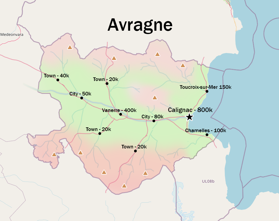
Geography
Avragne’s geography is inspired by the south of France and northwestern Italy.
Landscape
Both the north and south of the country are relatively mountainous (this can be tweaked if not in line with plans of neighbouring territories – I have based the topography on existing border shapes and surrounding features that are mapped). A main central river flows from the west and is surrounded mostly by flatland.
Climate
To my understanding, the territory generally falls under Csa, with Csb/Cfb at higher elevations.
Territory sketch
https://i.postimg.cc/7hnSHBL2/COUNTRYPLAN.png
 | Human geography |
|---|---|
| A brief description of the territory demographics, economic development, land occupation, infrastructure and mapping style |
Most of the population will be located along the main river, where several major cities including the capital will be found, as well as on the flatter coastal areas. Smaller towns will be located within the more mountainous areas. Estimated population of ~2 million.
Economy
GDP per capita of around 35,000 USD. The economy relies on agriculture, tourism and high-tech products.
Language
A mainly Franquese-speaking territory with possible Plevian influence and, to the west, linguistic influence from neighbouring Mperiye Sathriada (although I may need some help in identifying this).
Mapping style
The mapping style will be inspired by the south of France and northwestern Italy.
| History & culture | |
|---|---|
| A brief description of the intended culture and language |
Based off of the surrounding area, Avragne may have historically been part of the Romantian Empire, possibly even part of Franqueterre; gaining independence in the 19th century.
| Past mapping | |
|---|---|
| To support your request provide links to areas of OGF mapping which showcase your mapping skill. Mapping relevant to the requested theme & geography is especially useful | |
| The {{coord}} template can optionally be used to link to the OGF map - it results in a nice formatted link. Or you can paste in a URL. |
After giving up my previous territories and taking a break from OGF for a few years, my mapping examples are limited, but I've been working recently on these areas in the beginners zone:
- Beginning of detailed city quartier
- Central railway station
- General rural area
- Initial village sketch
(These tiles may still be in the process of updating)
| Username & date | |
|---|---|
| Sign and date the application by typing four tildes like this: ~~~~ |
KHBritish (talk) 22:01, 28 March 2024 (UTC)
 | Discussion |
|---|---|
| Discussion for clarification & decision |
 |
Territory application approved |
|---|---|
| Approved; no large changes to plans required ⸺ Bixelkoven (talk) (West Uletha Admin) 22:15, 30 March 2024 (UTC) | |
| Your provided mapping is quite good and is in par with the style imagined for the territory. It's not the largest in quantity, and I would've liked to see some mountainous mapping as well, however I trust you will provide good mapping examples of those in the future as well. Friendly suggestion to limit using grids from your urban mapping, feel free to experiment with free-flow street layouts more. Your geography plan is okay, do note that the mountains on your western border would be your main and highest mountain chain being part of a larger continental chain running north to south. The other mountainous areas shuld feature lower elevations, while probably staying as part of the main chain. Additionally, the language of Mperiye Sathriada is a conlang, so the info on it is limited, you may try to replicate it, but I cannot help further with that. Happy mapping! |