Forum:Territory application/UL08j Astria: Difference between revisions
(Created page with "<div class="forumheader" style="margin: 1; background-color: #eeeeee; text-align: left; padding: 5px;">'''Forums → Forum:Territory application|Territory...") |
No edit summary |
||
| Line 56: | Line 56: | ||
*{{coord|name=Sankt Nikolas|zoom=13|latitude=14.5531|longitude=-113.2105}} - some recent urban and rural mapping | *{{coord|name=Sankt Nikolas|zoom=13|latitude=14.5531|longitude=-113.2105}} - some recent urban and rural mapping | ||
*{{coord|name=Città di Peritano|zoom=15|latitude=50.8165|longitude=118.2776}} - some older urban and historic mapping | *{{coord|name=Città di Peritano|zoom=15|latitude=50.8165|longitude=118.2776}} - some older urban and historic mapping | ||
*{{coord|name=New Anderton|zoom=15|latitude=20.6780|longitude=86.4513}} - some older rural mapping | |||
*{{coord|name=Landscape of Minn-am-Gabőts|zoom=11|latitude=6.8191|longitude=140.6042}} - some older landscape mapping | *{{coord|name=Landscape of Minn-am-Gabőts|zoom=11|latitude=6.8191|longitude=140.6042}} - some older landscape mapping | ||
Revision as of 23:59, 12 April 2024
| Territory ID and proposed name | |
|---|---|
| The Territory ID (from OpenGeofiction:Territories, e.g. AR123a) and proposed name of the country |
UL08j : Astria (derivated from french/italian est, as for the region on the eastern shores of Pretannic Lake)
| Physical geography | |
|---|---|
| An overview of climate, topography and landscape of the country. It is advised to also create a sketch, you can add a link to this (hosted on imgur or similar) |
Topography:
[1] - terrain height is relative to the mean water level of the Pretannic Lake taken as the zero level.
Relatively flat terrain of southern and northern plains with some low hills is partially broken by mountainous and hilly terrain in the middle of the country. Southern plains extend from Plevia to Pretannic Lake and are part of the plains of northern Plevia.
Climate: Climate is influenced by the large body of water of the Pretannic Lake. Cfa is found in all the coastal areas of two surrounding lakes. Cfb is found in hilly terrain of the southern and central Astria. Dfb is reserved for the highest parts of the country.
Landscape: Landscape is inspired by northern Italy, especially by Veneto and Emilia-Romagna regions.

Pretannic Lake and Unnamed Lake shores.
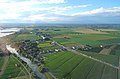
Southern plains

Central mountains

Tipical city in the plains

historic northern town

village in the central mountains


.jpg)
![[1]](https://i.postimg.cc/wMH9TWp5/Astria-OGF.png)
 | Human geography |
|---|---|
| A brief description of the territory demographics, economic development, land occupation, infrastructure and mapping style |
Demographics:
The country has about 5.4 million inhabitants. The metro area of the largest city on the pretannic coast has population of 800 000. The country is experiencing a phase of very slow population growth. Population is equally dispersed around the country.
Economy: Fertile plains and hills are still characterised by an intensive agriculture. The national industry is especially made of small and medium-sized businesses.
GDP (PPP) per capita is 58,000 Int'l$. Two major international highway corridors are stretching from south to the north. Rail network is noteworthy for its density.
Mapping style: Inspired by northern Italy.
| History & culture | |
|---|---|
| A brief description of the intended culture and language |
Language:
Variation of the Italian language, somewhat influenced by Gallo-italic languages.
Culture and History: Variation of the Italian culture, influenced by proximity of French and Germanic population. Historically part of "Roman Empire" Astria developed during "medieval period" as the alliance of smaller entities (city-states, counties, abbeys etc.) at the crossroads between Plevia, Franqueterre and Pretannia. Important regional identities caused the formation of the country separated from the other greater national states. In the 18th/19th century liberal ideas provoked creation of more cohesive political system which consolidated central government while maintaining strong regional governments.
Details to be developed in collaboration with neighbouring countries.
| Past mapping | |
|---|---|
| To support your request provide links to areas of OGF mapping which showcase your mapping skill. Mapping relevant to the requested theme & geography is especially useful | |
| The {{coord}} template can optionally be used to link to the OGF map - it results in a nice formatted link. Or you can paste in a URL. |
 Sankt Nikolas - some recent urban and rural mapping
- Città di Peritano - some older urban and historic mapping
- New Anderton - some older rural mapping
- Landscape of Minn-am-Gabőts - some older landscape mapping
| Username & date | |
|---|---|
| Sign and date the application by typing four tildes like this: ~~~~ |
William (talk) 22:46, 12 April 2024 (UTC)
 | Discussion |
|---|---|
| Discussion for clarification & decision |