Forum:Territory application/UL10-15
- Please fill in the information below to make a territory request.
| Territory ID and proposed name | |
|---|---|
| The Territory ID (from OpenGeofiction:Territories, e.g. AR123a) and proposed name of the country |
UL 10-15 - Norfric and Sufric
| Physical geography | |
|---|---|
| An overview of climate, topography and landscape of the country. It is advised to also create a sketch, you can add a link to this (hosted on imgur or similar) |
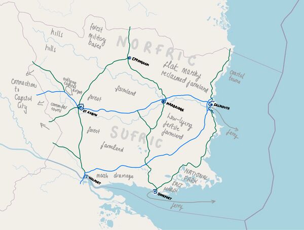
This area of Ingerland is broadly speaking flat and fertile. There is a distinct divide between the hillier west of the counties and the flatter eastern areas. The land meets the sea along the eastern and southern coasts - the eastern coast has long stretches of dune and tidal sands whilst the southern coast is more of an estuary with mud flats and salt marsh. Where the estuary meets the sea is a large area of saltmarsh which is a national park. The main river that forms the border between Norfric and Sufric lies in a fertile valley surrounded by man-made lakes, large areas of man-made drainage and coniferous forests planted to create hunting grounds for medieval kings.
 | Human geography |
|---|---|
| A brief description of the territory demographics, economic development, land occupation, infrastructure and mapping style |
The main economic activity in Norfric and Sufric has always been agriculture, particularly sheep farming, pig farming and arable use. The largest city is Salmouth (though its population is less than 450,000), a historic port which lies on the mouth of the River Sale. There are also ports on the estuary at Walport and Doveport, one of Ingerland's largest deepwater container ports sits just outside Doveport and the coast here is dotted with oil refineries and car manufacturers. Harbridge is best known for Harbridge University, founded in 1086, it sits on the confluence of the River Sale and River Harbourne. Eppingham is a quiet market town whose large church reflects the wealth of the medieval wool trade. St Aubyn is a cathedral city which is popular with commuters from the capital. There are only two motorways linking the capital city to Salmouth and linking Salmouth to the docks and manufacturing areas on the estuary coast.
| History & culture | |
|---|---|
| A brief description of the intended culture and language |
Norfric and Sufric were once ancient kingdoms before Ingerland was united in the (?) 11th century. During the medieval period they were centres of wealth and trade in Ingerland with the wool trade bringing in a large income and connecting the port towns of Salmouth and Doveport to the rest of Uletha. Harbridge was for many years one of the largest and most important cities in Ingerland. After the (?) Great Plague they found their populations decimated with many villages being left abandoned. With the Industrial Revolution their influence waned and they began to be seen as rural backwaters, particularly the eastern areas which lie well over an hour from the capital city. In the present day there is a great disparity of wealth and prosperity, some coastal towns and villages in Norfric have attracted wealthy settlers from the capital whilst some areas of Salmouth and Walport are amongst the poorest in the country.
| Past mapping | |
|---|---|
| To support your request provide links to areas of OGF mapping which showcase your mapping skill. Mapping relevant to the requested theme & geography is especially useful | |
| The {{coord}} template can optionally be used to link to the OGF map - it results in a nice formatted link. Or you can paste in a URL. |
I have mapped Myrcia for many years. I have also contributed to OpenStreetMap in the UK, mapping most of my hometown of Great Yarmouth in Norfolk.
| Username & date | |
|---|---|
| Sign and date the application by typing four tildes like this: ~~~~ |
Myrcia (talk) 20:55, 3 May 2023 (UTC)
 | Discussion |
|---|---|
| Discussion for clarification & decision |
