Forum:Territory application/UL27k - Rémnokkälja (exchange for UL12j)
- Please fill in the information below to make a territory request.
| Territory ID and proposed name | |
|---|---|
| The Territory ID (from OpenGeofiction:Territories, e.g. AR123a) and proposed name of the country |
UL27k - Rémnokkälja /'re:m.nok.kə.ɮa/
I decided to give up on UL12j (Weldoslendo) since UL08e as probable "OGF:Switzerland" does not exist anymore and Finno-Ugric continuum is also broken now, so the whole existence of UL12j in its current state looks rather meaningless.
| Physical geography | |
|---|---|
| An overview of climate, topography and landscape of the country. It is advised to also create a sketch, you can add a link to this (hosted on imgur or similar) |
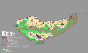
UL27k is a mountainous microstate located on a bank of a mid-size river. It can be divided into two parts by a mountain range. The northern half of a country lies near the beforementioned river, the other one has a small drainless lake.
The mountains do not rise above 2 500 m. and the lowest point is the lake - ca. 1 400 m. above sea level. The main river flows in the range of 1 750 m (the water source) to 1 475 m (the country border)
 | Human geography |
|---|---|
| A brief description of the territory demographics, economic development, land occupation, infrastructure and mapping style |
UL27k is an agrarian country.
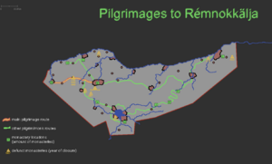
The permanent population is around 80 000 inhabitants, but temporary residents increase it to 100-120 thousands: these are the tourists and pilgrims.
The industry is almost absent, except for a few factories in the capital and bigger towns that produce everyday items for the country usage.
Roads
Rémnokkälja has only one trunk road. There are five primary roads and around 10 paved roads -- the rest of the road grid is unpaved and badly suited for the cars.
The narrow-gauge railway was built with the help of [major power] in 1st quarter of 20th century with the goal of creating a temporary transport link for a future "massive Trans-Axian railway corridor" that was immediatly abandoned when Great War started.
The standard gauge railway was constructed in late 1990s but it stays abandoned due to protests of local farmers, boatmen and truck company lobby in the legislature.
| History & culture | |
|---|---|
| A brief description of the intended culture and language |
Short history:
before 950 CE -- The land is inhabited by semi-nomadic tribes, that sometimes get into the sphere of influence of bigger powers.
ca. 950 CE -- Christianity is being brought from Ohemia to the Western coast of Axian peninsula. However, around a decade later, Christians underwent purges at various pagan kingdoms/tribal unions and most of them retreated to the mountains.
996 -- The first confirmed presence of Christian missionaries in Rémnokkälja.
Between 1000 and 1300 -- Due to isolation and influence of local religious practices, the Christianity in Rémnokkälja is being transformed into its own religion.
In Middle Ages, Rémnokkälja would see its rise as a center of education and culture -- for some time it was a neutral "monastic republic" that accepted scholars and monks from Axian peninsula. However, it would soon fall to havoc caused by the neighbouring countries trying to fight for Rémnokkälja. Eventually, due to import of new technologies from Bai-sphere and Central-East Uletha it would lose its prominence as an education center, keeping the status of pilgrimage destination.
Between 1700 and 1900 Rémnokkälja probably would fall into the sphere of influence of bigger powers -- e.g. Kalm (that had at least 2 colonies close to UL27k).
In the beginning of 20th century the country would restore its sovereignty (but probably as a vassal state of UL27j first). It again became a monastic republic with a "patriarch" being elected by the monastery representatives.
In 1967, an attempt was made by local intellectuals to turn Rémnokkälja into a republic and open it to the rest of the world "by force". However, the new government was then crushed by theocracy supporters and the isolationist policies were restored until late-2002.
In 2002-2007, more people started to support republican rule and eventually the theocratic monarchy was de-facto overthrown, however, the "patriarch" is still elected though he cannot control the civil government.
Culture
In terms of mapping style, Rémnokkälja is similar to Nepal/Bhutan/Sikkim.
Language
The language spoken in Rémnokkälja is a distant Indo-Iranian conlang with some influence from Tocharian (or at least what we know about Tocharian A/Tocharian B).
| Past mapping | |
|---|---|
| To support your request provide links to areas of OGF mapping which showcase your mapping skill. Mapping relevant to the requested theme & geography is especially useful | |
| The {{coord}} template can optionally be used to link to the OGF map - it results in a nice formatted link. Or you can paste in a URL. |
Weldoslendo: https://opengeofiction.net/#map=15/60.3629/62.5897&layers=B / https://opengeofiction.net/#map=14/60.6548/61.6069&layers=B / https://opengeofiction.net/#map=15/60.3940/62.6899&layers=B
Kwelede-peir (currently in the process of clean-up and relocation): https://opengeofiction.net/#map=16/-45.9007/53.8678&layers=B
Gharbiya: https://opengeofiction.net/#map=15/26.7363/8.3603&layers=B
| Username & date | |
|---|---|
| Sign and date the application by typing four tildes like this: ~~~~ |
Sudo91 (talk) 18:25, 15 October 2023 (UTC)
 | Discussion |
|---|---|
| Discussion for clarification & decision |
- Dear Sudo, thank you very much for your very thoughtful and detailed explanation. I cannot say anything on the reasons you cite to leave West Uletha, but I'd encourage you to reach out to the local admins there if you haven't done so yet. The only thing missing on your application is a few points about the climate. It seems like you already have an idea about this in mind as well, would you mind elaborating on this before concluding the application? Thanks and looking forward to your reply, Leowezy (talk) 19:42, 15 October 2023 (UTC)
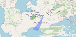
- Hello again, here are my thoughts about the climate. The prevailing winds flow from the southwest but some of them do not get past the mountains that surround the country from the south. Minor winds from the northern sea also do not get into the country as often as on the coast, but they still bring a significant amount of precipitation.
Here's the climate chart that I think would be fitting for the capital city -- referenced from the climate data of Harbin, Urumqi, Pyongyang, Khabarovsk and Sikkim. Sudo91 (talk) 15:02, 16 October 2023 (UTC)
- Hello again, here are my thoughts about the climate. The prevailing winds flow from the southwest but some of them do not get past the mountains that surround the country from the south. Minor winds from the northern sea also do not get into the country as often as on the coast, but they still bring a significant amount of precipitation.
 |
Territory application approved |
|---|---|
| approved, Leowezy (talk) 18:18, 16 October 2023 (UTC) | |
| optionally useful information for the user |


