User:Pawl: Difference between revisions
No edit summary |
m (→Ingerland: Add link) |
||
| (12 intermediate revisions by 2 users not shown) | |||
| Line 1: | Line 1: | ||
I'm Pawl (actually Paul, but I used the Welsh name here because I am mapping in Welsh). I joined OGF in 2015 but | {{Infobox user | ||
| ogf-username = Pawl | |||
| email = no | |||
| lang1 = EN | |||
| lang2 = | |||
| lang3 = | |||
| terr1 = Tircambry | |||
| terr1flag = Tircambry-national-flag.png | |||
| terr1relation = 22695 | |||
| terr2 = | |||
| terr2flag = | |||
| terr2relation = | |||
| coordinator1 = | |||
| coordinator2 = | |||
| collab1 = {{Ingerland}} (coordinator) | |||
}} | |||
I'm Pawl (actually Paul, but I used the Welsh name here because I am mapping in Welsh). I am English but live in south Wales. I joined OGF in 2015 but was fairly inactive for quite a while until 2023. I used to map UL11a (Tircambry) and Wesmandy (UL11e) but after a long period of inactivity I gave up UL11a and am converted Wesmandy into the new Tircambry! This allows me to keep a Welsh-speaking country while taking advantage of the more extensive mapping I had done in Wesmandy, as well as preferring its smaller size. | |||
Since 2023, I am also mapping Wesfolk in Ingerland. | |||
I am also interested in flags and heraldry and happy to help anyone designing flags or coats of arms for their territories. | I am also interested in flags and heraldry and happy to help anyone designing flags or coats of arms for their territories. | ||
| Line 5: | Line 24: | ||
==Tircambry== | ==Tircambry== | ||
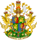
[[File:Tircambry-national-flag.png|150px|left|border:10px]][[File:Tircambry-royal-arms.png|130px|right|border:10px]] | [[File:Tircambry-national-flag.png|150px|left|border:10px]][[File:Tircambry-royal-arms.png|130px|right|border:10px]] | ||
Tircambry is a fairly small Cambric (Welsh)-speaking nation in northwestern Uletha. I had been mapping it as it was in 1400 with the intention of moving it forward century by century to the present day, but I am abandoning that approach and will start bringing the country into the modern day. | Tircambry is a fairly small Cambric (Welsh)-speaking nation in northwestern Uletha. I had been mapping it as it was in 1400 with the intention of moving it forward century by century to the present day, but I am abandoning that approach and will start bringing the country into the modern day. | ||
====Current activity==== | |||
March 2024 : Tircambry has been sadly neglected as I concentrate on Wesfolk in Ingerland, but I do intend to work soon either on the capital Caerarthen or the smaller historic city of Caerlyn. I have to brace myself to get back into Cambric/Welsh naming, though (I am not a Welsh speaker)! | |||
I still also need to re-write the history to take account of the new location and changed reality in West Uletha (e.g. having Ingerland as a neighbour). | |||
==Ingerland== | |||
[[File:Ingerland-arms-proposal-1.png|130px|right|border:10px]] | |||
I have been appointed coordinator for Ingerland and am looking forward to getting discussions going on various nation-building issues. The big one at the moment (May 2024) is the country's name because most Ingerland mappers are not happy with the current one, but we need to take into account that it has an impact beyond Ingerland itself. Fortunately, plenty of suggestions have been put forward so I hope we can decide this before too long. | |||
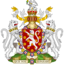
With my interest in heraldry, I have also been working on a [[Forum:Ingerland/Ingerland_coat_of_arms|proposal for an Ingerland coat of arms]] (right). I'd like to get this sorted so that it can go on the Ingerland wiki page, which will be created once the name is settled. | |||
===Wesfolk=== | |||
Wesfolk is an area, mostly a peninsula, in the west of Ingerland. It has some cities and ports but is largely rural with the main economic activities being farming and tourism, along with fishing, light industry, service industries, and naval facilities. Wesfolk is divided into four counties inspired by southwest England - Dunvan, Havset, Darlshire and Meltshire. I'm not entirely happy with the names so they may change. | |||
====Current activity==== | |||
May 2024: April was a quiet month mapping month compared to March - too much real life getting in the way! I'm currently working on the small seaside town of Bovymouth. | |||
{| class="wikitable" style="width:60%" | |||
|- | |||
! '''Bovymouth, {{Ingerland}}''' | |||
|- | |||
| {{#MultiMaps: center = 56.1189, 23.5195 | height = 600px | zoom = 15 | maxzoom = 19 | minzoom = 12 }} | |||
|- | |||
|} | |||
==Sandbox== | ==Sandbox== | ||
[[User | [[User:Pawl/Sandbox]] | ||
... | ... | ||
Latest revision as of 06:27, 6 May 2024
| Contact | Languages |
| |
EN |
| My Territories and Projects | |
Collaborative projects
| |
I'm Pawl (actually Paul, but I used the Welsh name here because I am mapping in Welsh). I am English but live in south Wales. I joined OGF in 2015 but was fairly inactive for quite a while until 2023. I used to map UL11a (Tircambry) and Wesmandy (UL11e) but after a long period of inactivity I gave up UL11a and am converted Wesmandy into the new Tircambry! This allows me to keep a Welsh-speaking country while taking advantage of the more extensive mapping I had done in Wesmandy, as well as preferring its smaller size.
Since 2023, I am also mapping Wesfolk in Ingerland.
I am also interested in flags and heraldry and happy to help anyone designing flags or coats of arms for their territories.
Tircambry
Tircambry is a fairly small Cambric (Welsh)-speaking nation in northwestern Uletha. I had been mapping it as it was in 1400 with the intention of moving it forward century by century to the present day, but I am abandoning that approach and will start bringing the country into the modern day.
Current activity
March 2024 : Tircambry has been sadly neglected as I concentrate on Wesfolk in Ingerland, but I do intend to work soon either on the capital Caerarthen or the smaller historic city of Caerlyn. I have to brace myself to get back into Cambric/Welsh naming, though (I am not a Welsh speaker)!
I still also need to re-write the history to take account of the new location and changed reality in West Uletha (e.g. having Ingerland as a neighbour).
Ingerland
I have been appointed coordinator for Ingerland and am looking forward to getting discussions going on various nation-building issues. The big one at the moment (May 2024) is the country's name because most Ingerland mappers are not happy with the current one, but we need to take into account that it has an impact beyond Ingerland itself. Fortunately, plenty of suggestions have been put forward so I hope we can decide this before too long.
With my interest in heraldry, I have also been working on a proposal for an Ingerland coat of arms (right). I'd like to get this sorted so that it can go on the Ingerland wiki page, which will be created once the name is settled.
Wesfolk
Wesfolk is an area, mostly a peninsula, in the west of Ingerland. It has some cities and ports but is largely rural with the main economic activities being farming and tourism, along with fishing, light industry, service industries, and naval facilities. Wesfolk is divided into four counties inspired by southwest England - Dunvan, Havset, Darlshire and Meltshire. I'm not entirely happy with the names so they may change.
Current activity
May 2024: April was a quiet month mapping month compared to March - too much real life getting in the way! I'm currently working on the small seaside town of Bovymouth.
| Bovymouth, |
|---|
Loading map... |
Sandbox
...


