Forum:Territory application/AR060-001 (Ingerish Asperia)
- Please fill in the information below to make a territory request.
| Territory ID and proposed name | |
|---|---|
| The Territory ID (from OpenGeofiction:Territories, e.g. AR123a) and proposed name of the country |
AR060-001∈⊾ƨ - Ingerish Asperia, Collaborative State
| Physical geography | |
|---|---|
| An overview of climate, topography and landscape of the country. With the exception of Beginner territories, you should always create a sketch map to illustrate & explain your plans. You can add a link to this (hosted on imgBB, Postimages or similar, but not imgur.com) |
The territory will have a primarily oceanic / temperate climate, given the latitude (similar to Sydney / Canberra IRL). The mountain range going through the middle of the territory will create plentiful rain on either side, and this will allow for arable land and agreeable weather all across the territory. The country will consist of flat eastern coastal plains, a large mountain range and hills that goes northwards, river valleys, and rugged coastline. The "fjords" in the plans are downgraded to less glaciated coast, but still influenced by the mountain range.
Plan:
-
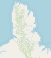 Base plan
 -
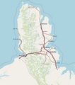 Geographic regions
 -
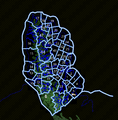 Administrative districts


 | Human geography |
|---|---|
| A brief description of the territory demographics, economic development, land occupation, infrastructure and mapping style |
The territory has cities focused on the more prominent river mouths. The east coast has three major cities, while the west coast has one major city. The east's flatter terrain allows for more development, farming land, smaller towns, and coastal development. The west coast is less populated and more isolated, with a focus on mining, fishing, and natural tourism. The northern part of the territory will have a large national park. The territory's main economic outputs are agriculture, mining, fishing, forestry, and some emerging advanced industries. The mapping style will take inspiration from mainly NZ and parts of south-east Aus for the natural landscapes, whereas Australia will be used mainly for the human infrastructure.
| History & culture | |
|---|---|
| A brief description of the intended culture and language |
Ingerish Asperia will be a mixture of NZ, Aus, and British Columbia (minorly). It will almost predominantly Ingerish-speaking. The state was historically an early part of Deodeca's history and has a strong identity as such. There will be minor immigrant cultures in the bigger cities and some minor Native Archantan representation.
This state will be a collaborative state through expressions of interest by mappers. The state will begin with general layout and landcover, and as interested persons join, a more organised system of sub stage areas / counties / zones to map will be established.
| Past mapping | |
|---|---|
| To support your request provide links to areas of OGF mapping which showcase your mapping skill. Mapping relevant to the requested theme & geography is especially useful. | |
| The {{coord}}, {{node}}, {{relation}} or {{scalehelper}} templates can optionally be used to link to the OGF map - they result in nicely formatted links. Or you can paste in a URL. |
 41.6349°S, 130.5945°E - example of general overall landcover
- 42.8352°S, 125.7001°E - example of mountainous/hilly landcover
- 43.0755°S, 124.2784°E - coastal mapping
- 42.8184°S, 124.4221°E - small town NZ/Aus style mapping
| Username & date | |
|---|---|
| Sign and date the application by typing four tildes (~~~~) without spaces or "nowiki" tags. |
Arlo (talk) 16:00, 8 April 2022 (UTC)
 | Discussion |
|---|---|
| Discussion for clarification & decision |
 |
Territory application approved |
|---|---|
| As discussed, I am approving this application for a second Deodeca collaborative province, in exchange for your FSA state. Please let me know when you are ready to officially open the province and I'll make the applicable changes on the wiki. -TheMayor (talk) 18:08, 9 April 2022 (UTC) | |
| As a reminder, Deodeca provinces are part of the larger Deodeca province, and as such you will be expected to represent the province in national conversations, coordination, and discussion. |